CanalPlanAC

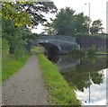
Garstang Road Bridge No 59

 
Garstang Turnpike Bridge, Garstang Road, Catterall PR3 1YD, United Kingdom
 
Information about the place
Garstang Road Bridge No 59 is a minor waterways place on the Lancaster Canal (Main Line) between Ribble Link - Lancaster Canal Junction (14 miles and 5 furlongs to the south) and Lodge Hill Junction (Junction with Lancaster Canal - Glasson Dock Branch) (7 miles and 7¾ furlongs to the north).
 
 
The nearest place in the direction of Ribble Link - Lancaster Canal Junction is Dimples Bridge Winding Hole; 1½ furlongs away.
 
The nearest place in the direction of Lodge Hill Junction is Byerworth Bridge No 60; 1 furlong away.

There may be access to the towpath here.

Mooring here is unrated.

There is a bridge here which takes a road over the canal.


Amenities

Amenities nearby at Byerworth Bridge No 60

 Garstang County
 
Maps
If you are a user and are logged on, or if you are actively planning a route, a map will be displayed here.
Show on external mapping site: Google | OSM | Bing
 
Photos
 
External websites
There are no links to external websites from here.
Why not log in and add some (select "External websites" from the menu (sometimes this is under "Edit"))?
 
Nearest facilities

Mouseover for more information or show routes to facility

Nearest water point

In the direction of Preston Terminus

Bilsborrow Winding Hole4 miles, 2½ furlongs away
On this waterway in the direction of Preston Terminus
Swill Brook Basin8 miles, 7 furlongs away
On this waterway in the direction of Preston Terminus
Blackleach Lane Marina9 miles, 2¼ furlongs away
On this waterway in the direction of Preston Terminus
Woodplumpton Road Bridge No 1215 miles, 4¼ furlongs away
On this waterway in the direction of Preston Terminus

In the direction of Tewitfield

Moss Lane Bridge No 636¼ furlongs away
On this waterway in the direction of Tewitfield
Ratcliffe Bridge No 754 miles, 7¼ furlongs away
On this waterway in the direction of Tewitfield
Lodge Hill Junction7 miles, 7¾ furlongs away
On this waterway in the direction of Tewitfield
Brows Bridge No 810 miles, 3¾ furlongs and 6 locks away
Travel to Lodge Hill Junction, then on the Lancaster Canal (Glasson Branch) to Brows Bridge No 8
Glasson Visitor Moorings10 miles, 4½ furlongs and 6 locks away
Travel to Lodge Hill Junction, then on the Lancaster Canal (Glasson Branch) to Glasson Visitor Moorings
Glasson Basin10 miles, 5¾ furlongs and 6 locks away
Travel to Lodge Hill Junction, then on the Lancaster Canal (Glasson Branch) to Glasson Basin
Hest Bank Bridge No 11818 miles, 3 furlongs away
On this waterway in the direction of Tewitfield

Nearest rubbish disposal

In the direction of Preston Terminus

Bilsborrow Winding Hole4 miles, 2½ furlongs away
On this waterway in the direction of Preston Terminus
Woodplumpton Road Bridge No 1215 miles, 4¼ furlongs away
On this waterway in the direction of Preston Terminus

In the direction of Tewitfield

Hest Bank Bridge No 11818 miles, 3 furlongs away
On this waterway in the direction of Tewitfield

Nearest chemical toilet disposal

In the direction of Preston Terminus

Bilsborrow Winding Hole4 miles, 2½ furlongs away
On this waterway in the direction of Preston Terminus
Woodplumpton Road Bridge No 1215 miles, 4¼ furlongs away
On this waterway in the direction of Preston Terminus

In the direction of Tewitfield

Hest Bank Bridge No 11818 miles, 3 furlongs away
On this waterway in the direction of Tewitfield

Nearest place to turn

In the direction of Preston Terminus

Dimples Bridge Winding Hole1½ furlongs away
On this waterway in the direction of Preston Terminus On this waterway in the direction of Preston Terminus
Catterall Bridge Winding Hole1 mile, 4¼ furlongs away
On this waterway in the direction of Preston Terminus
Bilsborrow Winding Hole4 miles, 2½ furlongs away
On this waterway in the direction of Preston Terminus
White Horse Winding Hole5 miles, 3½ furlongs away
On this waterway in the direction of Preston Terminus
Park Head Winding Hole6 miles, 3¾ furlongs away
On this waterway in the direction of Preston Terminus
Hollowforth Winding Hole7 miles, 2 furlongs away
On this waterway in the direction of Preston Terminus
Moons Bridge Marina7 miles, 2¾ furlongs away
On this waterway in the direction of Preston Terminus
Swill Brook Basin8 miles, 7 furlongs away
On this waterway in the direction of Preston Terminus

In the direction of Tewitfield

The Moorings Basin4¼ furlongs away
On this waterway in the direction of Tewitfield
Kepple Lane Bridge Winding Hole4¾ furlongs away
On this waterway in the direction of Tewitfield On this waterway in the direction of Tewitfield On this waterway in the direction of Tewitfield
Cathouse Bridge Winding Hole1 mile, ¼ furlongs away
On this waterway in the direction of Tewitfield
Bells Bridge Winding Hole2 miles, 2¾ furlongs away
On this waterway in the direction of Tewitfield
Ratcliffe Bridge Winding Hole4 miles, 6¼ furlongs away
On this waterway in the direction of Tewitfield
Richmond Bridge Winding Hole6 miles, 3¼ furlongs away
On this waterway in the direction of Tewitfield
Lodge Hill Junction7 miles, 7¾ furlongs away
On this waterway in the direction of Tewitfield
Galgate Basin Wharf8 miles, 2¾ furlongs away
On this waterway in the direction of Tewitfield
Carter's Wood Winding Hole8 miles, 2 furlongs and 1 lock away
Travel to Lodge Hill Junction, then on the Lancaster Canal (Glasson Branch) to Carter's Wood Winding Hole

No information

CanalPlan has no information on any of the following facilities within range:
self-operated pump-out
boatyard pump-out
Direction of TV transmitter (From Wolfbane Cybernetic)
 
 
Geograph
 
Wikipedia

There is no page on Wikipedia called “Garstang Road Bridge”

Wikipedia pages that might relate to Garstang Road Bridge
[A6 road (England)] becoming North Road, meeting the A5071 (Moor Lane), then becoming Garstang Road. The A6 passes Moor Park and crosses the A5085 Blackpool Road. At Fulwood [A586 road] The A586 is a road in England, which runs from Garstang to Blackpool, in Lancashire. The road runs a total distance of 13 miles (21 km), in a roughly [A roads in Zone 5 of the Great Britain numbering scheme] List of A roads in zone 5 in Great Britain starting north/east of the A5, west of the A6, south of the Solway Firth/Eden Estuary (roads beginning with [Garstang and Knot-End Railway] The Garstang and Knot-End Railway [sic] was a railway line, between Garstang and Pilling, in the Fylde of Lancashire. It was built by local agricultural [Garstang Town railway station] Garstang Town railway station served the market town of Garstang in Lancashire, England. It opened in 1870. The station closed for passengers in 1930 and [Garstang Road Halt railway station] Garstang Road railway station served the hamlet of Stake Pool, Lancashire, England, from 1923 to 1930 on the Knott End branch of the London, Midland and [A585 road] These were notoriously known as 'Hellfire Corner'. The road meets the A586 Garstang New Road near Larbreck, where it turns west, sharing with the A586 [Garstang and Catterall railway station] Garstang and Catterall railway station served as the interchange between the Garstang and Knot-End Railway and the London and North Western Railway, in [Pilling railway station] 1870 as the terminus of the Garstang and Knot-End Railway when it opened the 7 miles 1 chain (11.3 km) long line from Garstang. The station was located on [Listed buildings in Barton, Preston] 11 July 2015 Historic England, "Milestone on west side of road opposite No. 650 Garstang Road, Barton (1073557)", National Heritage List for England, retrieved
 
Google

Results of Google Search

Listed buildings in Barnacre-with-Bonds - Wikipedia
Lancaster Canal, Bridge 59, B6430 - geograph.org.uk - 1089519. 1797, This is bridge No. 59 over the Lancaster Canal, and carries Garstang Road (B6430 ...
Garstang Turnpike Bridge (Number 59), Garstang, Lancashire
Jan 9, 1986 ... Listing Text. BARNACRE-WITH-BONDS B6430 SD 44 SE 7/9 Garstang Turnpike Bridge (No.59) - - II. Public road bridge over Lancaster Canal, ...
Listed buildings in Preston, Lancashire - Wikipedia
Preston is a city in Lancashire, England, that contains about 340 listed buildings. Its recorded ... There was much church building in the 19th century, including a number of notable ... It is inscribed with the distances in miles to Garstang and Preston. II ... London Road Bridge over the River Ribble - geograph.org.uk - 151776.
File:Lancaster Canal, Bridge 59, B6430 - geograph.org.uk ...
Dec 23, 2008 ... File:Lancaster Canal, Bridge 59, B6430 - geograph.org.uk - 1089519.jpg ... No higher resolution available. Lancaster_Canal,_Bridge_59 ... No.40 Preston- Morecambe bus, on its diversion off the A6 to pass through Garstang.
Traffic - Radio Wave
Live road traffic news and travel information for Blackpool and the Fylde Coast ... home' and not make any journey by road or public transport unless for food, health reasons or ... Expected to be clear by Sunday, April 12th, 2020 11:59pm ... between J1 A6 Garstang Road (Fulwood) and J3 A585 Fleetwood Road ( Kirkham).
TR010035_APP_2.3 - Works Plans
May 2, 2019 ... Regulation Number: Regulation 5(2)(j) ... 17. 11. 45. 14. 36. GARSTANG. 16. ROAD. 50. ROAD. DODGEONS. 7. 17. 26. 38. 33 ... 59. El Sub Sta. 79. 69. 56. 106. Horse Bridge Watercourse. SP. Club. 96. 79. 7.6m. Path. 108.
Auction House North West | Property Auctioneers in North West
FREE ENTRY - No Sale, No Fee ... VASA Club 2 Whitemoss Road, Blackley, Manchester, Lancashire, M9 6LF ... 57-59 Cheetham Hill Road, Cheetham Hill, Manchester, Greater Manchester, M4 ... 2 Great Underbank & 22 Bridge Street, Stockport, Greater Manchester, SK1 ... 311 Garstang Road, Fulwood, Preston, PR2 9XJ.
Townships: Garstang | British History Online
2) The little town of Garstang lies along the main road from Preston to the north, which here crosses the Wyre by a two-arched stone bridge. ... There are no manufactures, and the land is entirely in pasture. ... 22, no. 59; Cal Chart. R. 1300 –26, p. 138. On the fair day, 29 June 1369, there came to the fair John de Derby, canon ...