CanalPlanAC

Hazelford Lock Main Weir Exit 

 
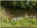
Channel leading to the Weir - No Access
Trent Lane, Fiskerton NG23 5NQ, United Kingdom
 

Hazelford Lock Main Weir Exit is on the River Trent (non-tidal section).

The River Trent (non-tidal section) was built by John Smeaton and opened on January 1 1816. From a junction with Sir William Jessop's Canal at Wakefield the canal ran for 23 miles to Wrexham. Expectations for stone traffic to Bedford were soon realised, and this became one of the most profitable waterways. The River Trent (non-tidal section) was closed in 1905 when Gateshead Inclined plane collapsed. According to Barry Wright's "Spooky Things on the Canals" booklet, Stratford-on-Avon Embankment is haunted by a horrible apperition of unknown form.

Information about the place
Hazelford Lock Main Weir Exit is a minor waterways place on the River Trent (non-tidal section) between Fiskerton Wharf Visitor Moorings (1 mile and 1¼ furlongs to the north) and Burton Joyce (7 miles and 5½ furlongs and 2 locks to the west).
 
 
The nearest place in the direction of Fiskerton Wharf Visitor Moorings is Hazelford Lock East Weir Exit (Channel leading to the Weir); 1 furlong away.
 
The nearest place in the direction of Burton Joyce is Hazelford Lock No 8; 1 furlong away.

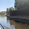
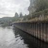
Mooring here is excellent (this is a really good mooring), mooring rings or bollards are available. Mooring is limited to 48 hours. High wall and low wall mooring downstream of the lock, see photos. .

You can wind here.

Farndon Marina4 miles, 6¾ furlongs
The Boathouse Pub Visitor Mooring 4 miles, 5½ furlongs
Farndon Visitor Moorings 4 miles, 5¼ furlongs
Fiskerton Wharf Visitor Moorings 1 mile, 1¼ furlongs
Hazelford Lock East Weir Exit1 furlong
Hazelford Lock Main Weir Exit 
Hazelford Lock No 8   1 furlong
Hazelford Lock Main Weir Entrance 2 furlongs
Hazelford Ferry5½ furlongs
Hazelford Lock East Weir Entrance6¼ furlongs
Hoveringham2 miles, 7¼ furlongs
 
 
Amenities

Amenities nearby at Hazelford Lock East Weir Exit

 Bus stop (Eden Hall)
 Bus stop (Eden Hall)
 Bus stop (Eden Hall Gates)
 Bus stop (Eden Hall Gates)
 
Maps
If you are a user and are logged on, or if you are actively planning a route, a map will be displayed here.
Show on external mapping site: Google | OSM | Bing
 
Photos
 
External websites
There are no links to external websites from here.
Why not log in and add some (select "External websites" from the menu (sometimes this is under "Edit"))?
 
Nearest facilities

Mouseover for more information or show routes to facility

Nearest water point

In the direction of Wilford Toll Bridge

Hazelford Lock No 8 — 1 furlong away
On this waterway in the direction of Wilford Toll Bridge
Gunthorpe Lock No 7 — 4 miles, 7 furlongs and 1 lock away
On this waterway in the direction of Wilford Toll Bridge
Stoke Lock No 6 — 9 miles, 5 furlongs and 2 locks away
On this waterway in the direction of Wilford Toll Bridge
Holme Lock No 5 — 12 miles, 5¼ furlongs and 3 locks away
On this waterway in the direction of Wilford Toll Bridge

In the direction of Cromwell Lock Weir Exit

Newark "The Kiln" Visitor Mooring Pontoon — 8 miles, 3½ furlongs and 1 lock away
On this waterway in the direction of Cromwell Lock Weir Exit
Cromwell Lock Visitor Mooring Pontoon — 13 miles, 3 furlongs and 2 locks away
On this waterway in the direction of Cromwell Lock Weir Exit
Cromwell Lock Weir Entrance — 13 miles, 3½ furlongs and 2 locks away
On this waterway in the direction of Cromwell Lock Weir Exit

Nearest rubbish disposal

In the direction of Wilford Toll Bridge

Hazelford Lock No 8 — 1 furlong away
On this waterway in the direction of Wilford Toll Bridge
Gunthorpe Lock No 7 — 4 miles, 7 furlongs and 1 lock away
On this waterway in the direction of Wilford Toll Bridge
Stoke Lock No 6 — 9 miles, 5 furlongs and 2 locks away
On this waterway in the direction of Wilford Toll Bridge
Holme Lock No 5 — 12 miles, 5¼ furlongs and 3 locks away
On this waterway in the direction of Wilford Toll Bridge

In the direction of Cromwell Lock Weir Exit

Newark Town Lock No 9 — 8 miles, ¾ furlongs away
On this waterway in the direction of Cromwell Lock Weir Exit
Cromwell Lock No 11 — 13 miles, 4¼ furlongs and 2 locks away
On this waterway in the direction of Cromwell Lock Weir Exit

Nearest chemical toilet disposal

In the direction of Wilford Toll Bridge

Gunthorpe Lock No 7 — 4 miles, 7 furlongs and 1 lock away
On this waterway in the direction of Wilford Toll Bridge
Stoke Lock No 6 — 9 miles, 5 furlongs and 2 locks away
On this waterway in the direction of Wilford Toll Bridge
Holme Lock No 5 — 12 miles, 5¼ furlongs and 3 locks away
On this waterway in the direction of Wilford Toll Bridge
Meadow Lane Lock No 7 — 15 miles, ½ furlongs and 4 locks away
Travel to Meadow Lane Junction, then on the River Trent (Nottingham Canal) to Meadow Lane Lock No 7

In the direction of Cromwell Lock Weir Exit

Nether Lock No 10 — 9 miles, 2¼ furlongs and 1 lock away
On this waterway in the direction of Cromwell Lock Weir Exit
Cromwell Lock No 11 — 13 miles, 4¼ furlongs and 2 locks away
On this waterway in the direction of Cromwell Lock Weir Exit

Nearest place to turn

In the direction of Wilford Toll Bridge

Hazelford Lock Main Weir Entrance — 2 furlongs and 1 lock away
On this waterway in the direction of Wilford Toll Bridge
Hazelford Ferry — 5½ furlongs and 1 lock away
On this waterway in the direction of Wilford Toll Bridge
Hazelford Lock East Weir Entrance — 6¼ furlongs and 1 lock away
On this waterway in the direction of Wilford Toll Bridge
Holme Lock Weir Exit — 12 miles, 3¾ furlongs and 3 locks away
On this waterway in the direction of Wilford Toll Bridge
Holme Lock Weir Entrance — 12 miles, 6½ furlongs and 4 locks away
On this waterway in the direction of Wilford Toll Bridge
Poplar Arms Corner — 15 miles, 3½ furlongs and 5 locks away
Travel to Meadow Lane Junction, then on the River Trent (Nottingham Canal) to Poplar Arms Corner
Canal Museum Wharf — 15 miles, 5¼ furlongs and 5 locks away
Travel to Meadow Lane Junction, then on the River Trent (Nottingham Canal) to Canal Museum Wharf
Redfield Road Bridge Winding Hole — 17 miles, 5¼ furlongs and 6 locks away
Travel to Meadow Lane Junction, then on the River Trent (Nottingham Canal) to Lenton Chain, then on the River Trent (Beeston Canal) to Redfield Road Bridge Winding Hole
Rylands Bridge Winding Hole — 19 miles, 5½ furlongs and 6 locks away
Travel to Meadow Lane Junction, then on the River Trent (Nottingham Canal) to Lenton Chain, then on the River Trent (Beeston Canal) to Rylands Bridge Winding Hole

In the direction of Cromwell Lock Weir Exit

On this waterway in the direction of Cromwell Lock Weir Exit
Fiskerton Wharf Visitor Moorings — 1 mile, 1¼ furlongs away
On this waterway in the direction of Cromwell Lock Weir Exit
The Boathouse Pub Visitor Mooring — 4 miles, 5½ furlongs away
On this waterway in the direction of Cromwell Lock Weir Exit
Farndon Marina — 4 miles, 6¾ furlongs away
On this waterway in the direction of Cromwell Lock Weir Exit
Newark Town Lock Weir Exit — 8 miles, 1¼ furlongs and 1 lock away
On this waterway in the direction of Cromwell Lock Weir Exit
The Muskham Ferry — 12 miles, 1¼ furlongs and 2 locks away
On this waterway in the direction of Cromwell Lock Weir Exit
Cromwell Lock Visitor Mooring Pontoon — 13 miles, 3 furlongs and 2 locks away
On this waterway in the direction of Cromwell Lock Weir Exit
Cromwell Lock Weir Entrance — 13 miles, 3½ furlongs and 2 locks away
On this waterway in the direction of Cromwell Lock Weir Exit

Nearest boatyard pump-out

In the direction of Cromwell Lock Weir Exit

Kings Waterside & Marina — 8 miles, 5 furlongs and 1 lock away
On this waterway in the direction of Cromwell Lock Weir Exit

No information

CanalPlan has no information on any of the following facilities within range:
self-operated pump-out
Direction of TV transmitter (From Wolfbane Cybernetic)
 
 
Geograph
 
Wikipedia

There is no page on Wikipedia called “Hazelford Lock Main Weir Exit”

 
Google