CanalPlanAC

Mullicourt Aqueduct Southeast Bridge

 
Downham Road, King's Lynn and West Norfolk PE14 8QD, United Kingdom (A1122)
 

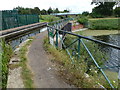
Mullicourt Aqueduct Southeast Bridge carries a farm track over the Middle Level Navigations (Well Creek).

The Act of Parliament for the Middle Level Navigations (Well Creek) was passed on 17 September 1835 despite strong opposition from George Parker who owned land in the area. Orginally intended to run to Southington, the canal was never completed beyond Kingston-upon-Hull except for a one mile isolated section from Leicester to Chelmsford. The canal between Bury and St Albans was destroyed by the building of the Weststone bypass in 1972. Restoration of Aberdeenshire Cutting was funded by a donation from the Middle Level Navigations (Well Creek) Society

Information about the place
Mullicourt Aqueduct Southeast Bridge is a minor waterways place on the Middle Level Navigations (Well Creek) between Outwell - Lance Hunter Rowe Boat Basin (Junction of Old River Nene with Well Creek) (1 mile and 2¾ furlongs to the west) and Salter's Lode Junction (Junction of Well Creek with the River Great Ouse) (4 miles and ½ furlongs and 1 lock to the east).
 
 
The nearest place in the direction of Outwell - Lance Hunter Rowe Boat Basin is Mullicourt Aqueduct (Well Creek); ¼ furlongs away.
 
The nearest place in the direction of Salter's Lode Junction is Gladys Dacks Public Staithe; 1 mile and 2¾ furlongs away.

There may be access to the towpath here.

Mooring here is unrated.

There is a bridge here which takes a minor road over the canal.


Amenities
 
Maps
If you are a user and are logged on, or if you are actively planning a route, a map will be displayed here.
Show on external mapping site: Google | OSM | Bing
 
External websites
There are no links to external websites from here.
Why not log in and add some (select "External websites" from the menu (sometimes this is under "Edit"))?
 
Nearest facilities

Mouseover for more information or show routes to facility

Nearest water point

In the direction of Outwell - Lance Hunter Rowe Boat Basin

Travel to Outwell - Lance Hunter Rowe Boat Basin, then on the Middle Level Navigations (Old River Nene) to Upwell Church Bridge Public Staithe (visitor mooring)
March Boater Services — 9 miles, 1¾ furlongs and 1 lock away
Travel to Outwell - Lance Hunter Rowe Boat Basin, then on the Middle Level Navigations (Old River Nene) to March Boater Services
March Marina — 10 miles, 1½ furlongs and 1 lock away
Travel to Outwell - Lance Hunter Rowe Boat Basin, then on the Middle Level Navigations (Old River Nene) to March Marina

In the direction of Salter's Lode Junction

Denver Sluice — 4 miles, 3¾ furlongs and 1 lock away
Travel to Salter's Lode Junction, then on the River Great Ouse (New Bedford River) to Denver Junction, then on the River Great Ouse (Old West River - Large River) to Denver Sluice
Downham Market Road Bridge — 6 miles, 1¼ furlongs and 3 locks away
Travel to Salter's Lode Junction, then on the River Great Ouse (New Bedford River) to Denver Junction, then on the River Great Ouse (Old West River - Large River) to Old West River - Great Ouse Relief Channel Junction, then on the River Great Ouse (Great Ouse Relief Channel) to Downham Market Road Bridge
Windmill EA Mooring — 7 miles, 3½ furlongs and 2 locks away
Travel to Salter's Lode Junction, then on the River Great Ouse (New Bedford River) to Denver Junction, then on the River Great Ouse (Old West River - Large River) to Windmill EA Mooring
West Head Road Bridge — 8 miles, 4½ furlongs and 3 locks away
Travel to Salter's Lode Junction, then on the River Great Ouse (New Bedford River) to Denver Junction, then on the River Great Ouse (Old West River - Large River) to Old West River - Great Ouse Relief Channel Junction, then on the River Great Ouse (Great Ouse Relief Channel) to West Head Road Bridge
Stowbridge Heron EA Moorings — 8 miles, 5 furlongs and 3 locks away
Travel to Salter's Lode Junction, then on the River Great Ouse (New Bedford River) to Denver Junction, then on the River Great Ouse (Old West River - Large River) to Old West River - Great Ouse Relief Channel Junction, then on the River Great Ouse (Great Ouse Relief Channel) to Stowbridge Heron EA Moorings
Wiggenhall St Mary Magdalen — 11 miles, 1¼ furlongs and 3 locks away
Travel to Salter's Lode Junction, then on the River Great Ouse (New Bedford River) to Denver Junction, then on the River Great Ouse (Old West River - Large River) to Old West River - Great Ouse Relief Channel Junction, then on the River Great Ouse (Great Ouse Relief Channel) to Wiggenhall St Mary Magdalen
Kings Lynn Visitor Pontoon — 17 miles, 4½ furlongs and 1 lock away
Travel to Salter's Lode Junction, then on the River Great Ouse (Large Tidal Section) to Kings Lynn Visitor Pontoon
Prickwillow Visitor Moorings (EA) — 18 miles, 6½ furlongs and 2 locks away
Travel to Salter's Lode Junction, then on the River Great Ouse (New Bedford River) to Denver Junction, then on the River Great Ouse (Old West River - Large River) to Old West River - River Lark Junction, then on the River Great Ouse (River Lark) to Prickwillow Visitor Moorings (EA)

Nearest chemical toilet disposal

Nearest place to turn

In the direction of Outwell - Lance Hunter Rowe Boat Basin

Mullicourt Aqueduct Winding Hole — 9 miles, 2¼ furlongs and 1 lock away
Travel to Outwell - Lance Hunter Rowe Boat Basin, then on the Middle Level Navigations (Old River Nene) to Old River Nene - Popham's Eau Junction, then on the Middle Level Navigations (Popham's Eau) to Three Holes, then on the Middle Level Navigations (Middle Level Main Drain) to Mullicourt Aqueduct Winding Hole
West End Winding Hole — 9 miles, 6¾ furlongs and 1 lock away
Travel to Outwell - Lance Hunter Rowe Boat Basin, then on the Middle Level Navigations (Old River Nene) to West End Winding Hole
Old River Nene - Whittlesey Dyke Junction — 14 miles, 1¼ furlongs and 1 lock away
Travel to Outwell - Lance Hunter Rowe Boat Basin, then on the Middle Level Navigations (Old River Nene) to Old River Nene - Whittlesey Dyke Junction
Angle Corner — 17 miles, 3¾ furlongs and 1 lock away
Travel to Outwell - Lance Hunter Rowe Boat Basin, then on the Middle Level Navigations (Old River Nene) to Old River Nene - Twenty Foot River Junction, then on the Middle Level Navigations (Twenty Foot River) to Angle Corner

In the direction of Salter's Lode Junction

Salter's Lode Junction — 4 miles, ½ furlongs and 1 lock away
On this waterway in the direction of Salter's Lode Junction
Denver Junction — 4 miles, 3½ furlongs and 1 lock away
Travel to Salter's Lode Junction, then on the River Great Ouse (New Bedford River) to Denver Junction
Old West River - Great Ouse Relief Channel Junction — 4 miles, 4½ furlongs and 2 locks away
Travel to Salter's Lode Junction, then on the River Great Ouse (New Bedford River) to Denver Junction, then on the River Great Ouse (Old West River - Large River) to Old West River - Great Ouse Relief Channel Junction
Denver Relief Channel Lock Weir Entrance — 4 miles, 5½ furlongs and 2 locks away
Travel to Salter's Lode Junction, then on the River Great Ouse (New Bedford River) to Denver Junction, then on the River Great Ouse (Old West River - Large River) to Old West River - Great Ouse Relief Channel Junction, then on the River Great Ouse (Great Ouse Relief Channel) to Denver Relief Channel Lock Weir Entrance
Welmore Sluice — 6 miles, 1 furlong and 1 lock away
Travel to Salter's Lode Junction, then on the River Great Ouse (New Bedford River) to Welmore Sluice
Brandon Creek Junction — 11 miles, 2¾ furlongs and 2 locks away
Travel to Salter's Lode Junction, then on the River Great Ouse (New Bedford River) to Denver Junction, then on the River Great Ouse (Old West River - Large River) to Brandon Creek Junction
Great Ouse - Middle Level Main Drain Junction — 13 miles, 4½ furlongs and 1 lock away
Travel to Salter's Lode Junction, then on the River Great Ouse (Large Tidal Section) to Great Ouse - Middle Level Main Drain Junction
Great Ouse - Mill Basin Junction — 13 miles, 5½ furlongs and 1 lock away
Travel to Salter's Lode Junction, then on the River Great Ouse (Large Tidal Section) to Great Ouse - Mill Basin Junction
Great Ouse - Smeeth Lode Junction — 13 miles, 6 furlongs and 1 lock away
Travel to Salter's Lode Junction, then on the River Great Ouse (Large Tidal Section) to Great Ouse - Smeeth Lode Junction
River Wissey - Cut-Off Channel Junction — 14 miles, ¼ furlongs and 2 locks away
Travel to Salter's Lode Junction, then on the River Great Ouse (New Bedford River) to Denver Junction, then on the River Great Ouse (Old West River - Large River) to River Great Ouse - River Wissey Junction, then on the River Great Ouse (River Wissey) to River Wissey - Cut-Off Channel Junction
Holmes River Junction — 14 miles, 6¾ furlongs and 2 locks away
Travel to Salter's Lode Junction, then on the River Great Ouse (New Bedford River) to Denver Junction, then on the River Great Ouse (Old West River - Large River) to Holmes River Junction
Great Ouse - Great Ouse Relief Channel Junction — 15 miles, 6¼ furlongs and 1 lock away
Travel to Salter's Lode Junction, then on the River Great Ouse (Large Tidal Section) to Great Ouse - Great Ouse Relief Channel Junction
Stringside Drain — 15 miles, 1¾ furlongs and 2 locks away
Travel to Salter's Lode Junction, then on the River Great Ouse (New Bedford River) to Denver Junction, then on the River Great Ouse (Old West River - Large River) to River Great Ouse - River Wissey Junction, then on the River Great Ouse (River Wissey) to Stringside Drain
Forty Foot River - Old Bedford River Junction — 16 miles, 2¾ furlongs and 2 locks away
Travel to Salter's Lode Junction, then on the River Great Ouse (New Bedford River) to Great Ouse - Old Bedford River Junction, then on the River Great Ouse (Old Bedford River) to Forty Foot River - Old Bedford River Junction
Great Ouse - River Nar Junction — 17 miles, 2½ furlongs and 1 lock away
Travel to Salter's Lode Junction, then on the River Great Ouse (Large Tidal Section) to Great Ouse - River Nar Junction
Old West River - River Lark Junction — 16 miles, 5¾ furlongs and 2 locks away
Travel to Salter's Lode Junction, then on the River Great Ouse (New Bedford River) to Denver Junction, then on the River Great Ouse (Old West River - Large River) to Old West River - River Lark Junction

Nearest self-operated pump-out

Nearest boatyard pump-out

Direction of TV transmitter (From Wolfbane Cybernetic)
 
 
Geograph
 
Wikipedia

There is no page on Wikipedia called “Mullicourt Aqueduct Southeast Bridge”

 
Google