Hatfield Road Railway Bridge
is a minor waterways place
on the Sheffield and South Yorkshire Navigation (Stainforth and Keadby Canal) between
Stainforth Junction (Junction of Sheffield and South Yorkshire Navigation and Stainforth and Keadby Canal) (3 miles and 2¼ furlongs
and 1 lock
to the west) and
Keadby Visitor Moorings (9 miles and 3 furlongs
to the east).
The nearest place in the direction of Stainforth Junction is Hatfield Road Pipe Bridge;
¼ furlongs
away.
The nearest place in the direction of Keadby Visitor Moorings is Blue Water Marina;
2 furlongs
away.
This is a pinch point. The normal maximum dimensions for a boat on this waterway are 61 feet and 6 inches long, 15 feet and 6 inches wide and 16 feet high (the maxium draught are unknown), but to pass through here the maximum dimensions are 11 feet and 10 inches high.
Mooring here is unrated.
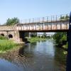
There is a bridge here which takes a railway over the canal.
Thorne Lock No 16 | 5¾ furlongs | |
Thorne Visitor Moorings | 3¼ furlongs | |
Thorne Swing Bridge | 3 furlongs | |
South Parade Bridge | 2¾ furlongs | |
Hatfield Road Pipe Bridge | ¼ furlongs | |
Hatfield Road Railway Bridge | ||
Blue Water Marina | 2 furlongs | |
Wykewell Lift Bridge | 4¼ furlongs | |
Moor Road Swing Bridge | 7 furlongs | |
Maud's Swing Bridge | 2 miles, ¼ furlongs | |
Medge Hall Swing Bridge | 3 miles, 6½ furlongs |
Amenities nearby at Blue Water Marina
- S&SY navigation info — associated with Sheffield and South Yorkshire Navigation
- Sheffield & South Yorkshire navigation info from IWA
Mouseover for more information or show routes to facility
Nearest water point
In the direction of Stainforth Junction
Thorne Visitor Moorings — 3¼ furlongs away
On this waterway in the direction of Stainforth Junction
Bramwith Swing Bridge — 4 miles, 6 furlongs and 1 lock away
Travel to Stainforth Junction, then on the Sheffield and South Yorkshire Navigation (Bramwith to Stainforth) to Bramwith Swing Bridge
Bramwith Lock No 14 — 5 miles, ¾ furlongs and 1 lock away
Travel to Stainforth Junction, then on the Sheffield and South Yorkshire Navigation (Bramwith to Stainforth) to Bramwith Lock No 14
Barnby Dun Lift Bridge — 6 miles, 3½ furlongs and 2 locks away
Travel to Stainforth Junction, then on the Sheffield and South Yorkshire Navigation (Bramwith to Stainforth) to Bramwith Junction, then on the Sheffield and South Yorkshire Navigation (Main Line) to Barnby Dun Lift Bridge
Long Sandall Lock No 13 — 8 miles, 4¾ furlongs and 2 locks away
Travel to Stainforth Junction, then on the Sheffield and South Yorkshire Navigation (Bramwith to Stainforth) to Bramwith Junction, then on the Sheffield and South Yorkshire Navigation (Main Line) to Long Sandall Lock No 13
Doncaster Visitor Pontoon Moorings — 11 miles, 6¼ furlongs and 3 locks away
Travel to Stainforth Junction, then on the Sheffield and South Yorkshire Navigation (Bramwith to Stainforth) to Bramwith Junction, then on the Sheffield and South Yorkshire Navigation (Main Line) to Doncaster Visitor Pontoon Moorings
Doncaster Town Lock No 12 — 12 miles, ½ furlongs and 3 locks away
Travel to Stainforth Junction, then on the Sheffield and South Yorkshire Navigation (Bramwith to Stainforth) to Bramwith Junction, then on the Sheffield and South Yorkshire Navigation (Main Line) to Doncaster Town Lock No 12
Pollington Visitor Mooring — 12 miles, 7¼ furlongs and 3 locks away
Travel to Stainforth Junction, then on the Sheffield and South Yorkshire Navigation (Bramwith to Stainforth) to Bramwith Junction, then on the Sheffield and South Yorkshire Navigation (New Junction Canal) to Sykehouse Junction, then on the Aire and Calder Navigation (Main Line - Goole to Castleford) to Pollington Visitor Mooring
Pollington Manor Swing Bridge — 12 miles, 7¾ furlongs and 3 locks away
Travel to Stainforth Junction, then on the Sheffield and South Yorkshire Navigation (Bramwith to Stainforth) to Bramwith Junction, then on the Sheffield and South Yorkshire Navigation (New Junction Canal) to Sykehouse Junction, then on the Aire and Calder Navigation (Main Line - Goole to Castleford) to Pollington Manor Swing Bridge
Sprotbrough Lock No 11 — 15 miles, 2¾ furlongs and 4 locks away
Travel to Stainforth Junction, then on the Sheffield and South Yorkshire Navigation (Bramwith to Stainforth) to Bramwith Junction, then on the Sheffield and South Yorkshire Navigation (Main Line) to Sprotbrough Lock No 11
Dutch Riverside — 17 miles, ½ furlongs and 3 locks away
Travel to Stainforth Junction, then on the Sheffield and South Yorkshire Navigation (Bramwith to Stainforth) to Bramwith Junction, then on the Sheffield and South Yorkshire Navigation (New Junction Canal) to Sykehouse Junction, then on the Aire and Calder Navigation (Main Line - Goole to Castleford) to Dutch Riverside
Goole Marina — 17 miles, 2 furlongs and 3 locks away
Travel to Stainforth Junction, then on the Sheffield and South Yorkshire Navigation (Bramwith to Stainforth) to Bramwith Junction, then on the Sheffield and South Yorkshire Navigation (New Junction Canal) to Sykehouse Junction, then on the Aire and Calder Navigation (Main Line - Goole to Castleford) to Goole Marina
Whitley Lock No 12 — 16 miles, 5¾ furlongs and 4 locks away
Travel to Stainforth Junction, then on the Sheffield and South Yorkshire Navigation (Bramwith to Stainforth) to Bramwith Junction, then on the Sheffield and South Yorkshire Navigation (New Junction Canal) to Sykehouse Junction, then on the Aire and Calder Navigation (Main Line - Goole to Castleford) to Whitley Lock No 12
Mexborough Low Lock No 10 — 18 miles, 6¼ furlongs and 5 locks away
Travel to Stainforth Junction, then on the Sheffield and South Yorkshire Navigation (Bramwith to Stainforth) to Bramwith Junction, then on the Sheffield and South Yorkshire Navigation (Main Line) to Mexborough Low Lock No 10
In the direction of Keadby Junction
Keadby Visitor Moorings — 9 miles, 3 furlongs away
On this waterway in the direction of Keadby JunctionNearest rubbish disposal
In the direction of Stainforth Junction
Thorne Visitor Moorings — 3¼ furlongs away
On this waterway in the direction of Stainforth Junction
Bramwith Swing Bridge — 4 miles, 6 furlongs and 1 lock away
Travel to Stainforth Junction, then on the Sheffield and South Yorkshire Navigation (Bramwith to Stainforth) to Bramwith Swing Bridge
Barnby Dun Lift Bridge — 6 miles, 3½ furlongs and 2 locks away
Travel to Stainforth Junction, then on the Sheffield and South Yorkshire Navigation (Bramwith to Stainforth) to Bramwith Junction, then on the Sheffield and South Yorkshire Navigation (Main Line) to Barnby Dun Lift Bridge
Doncaster Visitor Pontoon Moorings — 11 miles, 6¼ furlongs and 3 locks away
Travel to Stainforth Junction, then on the Sheffield and South Yorkshire Navigation (Bramwith to Stainforth) to Bramwith Junction, then on the Sheffield and South Yorkshire Navigation (Main Line) to Doncaster Visitor Pontoon Moorings
Dutch Riverside — 17 miles, ½ furlongs and 3 locks away
Travel to Stainforth Junction, then on the Sheffield and South Yorkshire Navigation (Bramwith to Stainforth) to Bramwith Junction, then on the Sheffield and South Yorkshire Navigation (New Junction Canal) to Sykehouse Junction, then on the Aire and Calder Navigation (Main Line - Goole to Castleford) to Dutch Riverside
Goole Marina — 17 miles, 2 furlongs and 3 locks away
Travel to Stainforth Junction, then on the Sheffield and South Yorkshire Navigation (Bramwith to Stainforth) to Bramwith Junction, then on the Sheffield and South Yorkshire Navigation (New Junction Canal) to Sykehouse Junction, then on the Aire and Calder Navigation (Main Line - Goole to Castleford) to Goole Marina
Whitley Lock No 12 — 16 miles, 5¾ furlongs and 4 locks away
Travel to Stainforth Junction, then on the Sheffield and South Yorkshire Navigation (Bramwith to Stainforth) to Bramwith Junction, then on the Sheffield and South Yorkshire Navigation (New Junction Canal) to Sykehouse Junction, then on the Aire and Calder Navigation (Main Line - Goole to Castleford) to Whitley Lock No 12
In the direction of Keadby Junction
Keadby Visitor Moorings — 9 miles, 3 furlongs away
On this waterway in the direction of Keadby JunctionNearest chemical toilet disposal
In the direction of Stainforth Junction
Thorne Visitor Moorings — 3¼ furlongs away
On this waterway in the direction of Stainforth Junction
Bramwith Swing Bridge — 4 miles, 6 furlongs and 1 lock away
Travel to Stainforth Junction, then on the Sheffield and South Yorkshire Navigation (Bramwith to Stainforth) to Bramwith Swing Bridge
Barnby Dun Lift Bridge — 6 miles, 3½ furlongs and 2 locks away
Travel to Stainforth Junction, then on the Sheffield and South Yorkshire Navigation (Bramwith to Stainforth) to Bramwith Junction, then on the Sheffield and South Yorkshire Navigation (Main Line) to Barnby Dun Lift Bridge
Dutch Riverside — 17 miles, ½ furlongs and 3 locks away
Travel to Stainforth Junction, then on the Sheffield and South Yorkshire Navigation (Bramwith to Stainforth) to Bramwith Junction, then on the Sheffield and South Yorkshire Navigation (New Junction Canal) to Sykehouse Junction, then on the Aire and Calder Navigation (Main Line - Goole to Castleford) to Dutch Riverside
Goole Marina — 17 miles, 2 furlongs and 3 locks away
Travel to Stainforth Junction, then on the Sheffield and South Yorkshire Navigation (Bramwith to Stainforth) to Bramwith Junction, then on the Sheffield and South Yorkshire Navigation (New Junction Canal) to Sykehouse Junction, then on the Aire and Calder Navigation (Main Line - Goole to Castleford) to Goole Marina
Whitley Lock No 12 — 16 miles, 5¾ furlongs and 4 locks away
Travel to Stainforth Junction, then on the Sheffield and South Yorkshire Navigation (Bramwith to Stainforth) to Bramwith Junction, then on the Sheffield and South Yorkshire Navigation (New Junction Canal) to Sykehouse Junction, then on the Aire and Calder Navigation (Main Line - Goole to Castleford) to Whitley Lock No 12
In the direction of Keadby Junction
Keadby Visitor Moorings — 9 miles, 3 furlongs away
On this waterway in the direction of Keadby JunctionNearest place to turn
In the direction of Stainforth Junction
Huddle Grounds Winding Hole — 2 miles, 6¾ furlongs and 1 lock away
On this waterway in the direction of Stainforth Junction
Wheatley Hall Road Winding Hole — 9 miles, 5½ furlongs and 3 locks away
Travel to Stainforth Junction, then on the Sheffield and South Yorkshire Navigation (Bramwith to Stainforth) to Bramwith Junction, then on the Sheffield and South Yorkshire Navigation (Main Line) to Wheatley Hall Road Winding Hole
Gas House Bight — 11 miles, 4¾ furlongs and 3 locks away
Travel to Stainforth Junction, then on the Sheffield and South Yorkshire Navigation (Bramwith to Stainforth) to Bramwith Junction, then on the Sheffield and South Yorkshire Navigation (Main Line) to Gas House Bight
Doncaster Visitor Pontoon Moorings — 11 miles, 6¼ furlongs and 3 locks away
Travel to Stainforth Junction, then on the Sheffield and South Yorkshire Navigation (Bramwith to Stainforth) to Bramwith Junction, then on the Sheffield and South Yorkshire Navigation (Main Line) to Doncaster Visitor Pontoon Moorings
Sprotbrough Lock Weir Exit — 15 miles, 2¼ furlongs and 4 locks away
Travel to Stainforth Junction, then on the Sheffield and South Yorkshire Navigation (Bramwith to Stainforth) to Bramwith Junction, then on the Sheffield and South Yorkshire Navigation (Main Line) to Sprotbrough Lock Weir Exit
Viking Marina — 17 miles, 1¼ furlongs and 3 locks away
Travel to Stainforth Junction, then on the Sheffield and South Yorkshire Navigation (Bramwith to Stainforth) to Bramwith Junction, then on the Sheffield and South Yorkshire Navigation (New Junction Canal) to Sykehouse Junction, then on the Aire and Calder Navigation (Main Line - Goole to Castleford) to Viking MarinaNearest self-operated pump-out
In the direction of Stainforth Junction
Long Sandall Lock No 13 — 8 miles, 4¾ furlongs and 2 locks away
Travel to Stainforth Junction, then on the Sheffield and South Yorkshire Navigation (Bramwith to Stainforth) to Bramwith Junction, then on the Sheffield and South Yorkshire Navigation (Main Line) to Long Sandall Lock No 13Nearest boatyard pump-out
In the direction of Keadby Junction
Blue Water Marina — 2 furlongs away
On this waterway in the direction of Keadby Junction
In the direction of Stainforth Junction
Thorne Swing Bridge — 3 furlongs away
On this waterway in the direction of Stainforth Junction
Goole Marina — 17 miles, 2 furlongs and 3 locks away
Travel to Stainforth Junction, then on the Sheffield and South Yorkshire Navigation (Bramwith to Stainforth) to Bramwith Junction, then on the Sheffield and South Yorkshire Navigation (New Junction Canal) to Sykehouse Junction, then on the Aire and Calder Navigation (Main Line - Goole to Castleford) to Goole MarinaDirection of TV transmitter (From Wolfbane Cybernetic)
There is no page on Wikipedia called “Hatfield Road Railway Bridge”
Wikipedia pages that might relate to Hatfield Road Railway Bridge
[Hatfield and St Albans Railway]
The Hatfield & St Albans Railway was a branch of the Great Northern Railway which connected the Hertfordshire towns of St Albans and Hatfield. It opened
[Lea Valley Walk]
The path carries on under the Broxbourne to the Nazeing road bridge, close to Broxbourne railway station. Approximately 13.1 miles (21.1 km) The Crown public
[Ayot Greenway]
North Road. Walkers and cyclists then use a road bridge over the A1(M) and pick up the trail again just north of Ayot St. Peter at what was its railway station
[Hatfield railway station]
Hatfield railway station serves the town of Hatfield in Hertfordshire, England. The station is managed by Great Northern. It is 17 miles 54 chains (28
[Alban Way]
along a former railway line in Hertfordshire, England, that has been constructed along the route of the former Hatfield to St Albans railway line. It runs
[River Don, Yorkshire]
in dismantling railway vehicles. This bridge carries Stevenson Road over the River Don and connects Brightside Lane with Attercliffe Road. It was named
[Axholme Joint Railway]
January 1905. A branch to Hatfield Moor was opened in 1909, but traffic from the peat works at Hatfield did not start to use the railway until 1913, when the
[Hatfield, Hertfordshire]
there. Hatfield lies 20 miles (30 kilometres) north of London beside the A1(M) motorway and has direct trains to London King's Cross railway station
[The Galleria, Hatfield]
outlet centre in Hatfield, Hertfordshire, England. The centre developed in the 1980s as part of a plan to reduce congestion in Hatfield while increasing
[London King's Cross railway station]
Hornsey in 1850, Holloway Road in 1856, Wood Green in 1859 and Seven Sisters Road (now Finsbury Park) in 1861. Midland Railway services to Leicester via
Results of Google Search
Hatfield and St Albans Railway - WikipediaThe Hatfield & St Albans Railway was a branch of the Great Northern Railway which connected the Hertfordshire towns of St Albans and Hatfield. It opened in 1865 with the principal aim of allowing St Albans traffic to access the Great Northern's main line to London at Hatfield, but soon came into difficulties when the ...
LONDON RD. LONDON RO. AD. HOLY. WELL HILL. HIGH ST. ST PETER'S ST. HATFIELD RD. HATFIELD RD. HATFIELD RD. Alban Way. Alban Way .... Way passes under a huge railway bridge carrying today's mainline rail traffic. St Albans Abbey. St Albans. Start/Finish. Just off Riverside Road and just by the access ...
Passing under Ferry Lane A503 road bridge.Close by is the Ferry Boat Inn public house and Tottenham Hale station. The path passes under the London Overground Gospel Oak to Barking line and Lea Valley Lines railway bridges as the towpath skirts the West Warwick Reservoir further to the east are the East Warwick ...
Mar 3, 2011 ... The new Midland Railway crossing over the St Albans - Hatfield Railway at London Road Station, St Albans, shortly after opening in 1868. The branch line was only three years older. © St Albans Museums. The 60-foot arch of the 1868 Midland Railway Bridge, St Albans, looking east up the long haul to The ...
The Alban Way is a cycle path in Hertfordshire, England, that has been constructed along the route of the former Hatfield to St Albans railway line. It runs from St Albans, close to St Albans Abbey railway station and the site of Roman Verulamium, through Fleetville and Smallford to Hatfield, ending close to Hatfield railway ...
Oct 24, 2017 ... A 14-year-old was attacked after he refused to give robbers the password for his iPhone.
This cycling tour takes you along the nicest roads in the municipality of Datchworth. Fully paved roads along this route. There are some tough climbs along this route (but trained cyclist will probably be laughing at this). Recreational along a bridge: Southdown Road Skew Bridge. You'll be doing a nice loop. If the weather ...
606552, NORTHAMPTON- BRIDGE RECONSTRUCTION, N-19-059, I-91 OVER US 5/BMRR & N-19-060, I-91 OVER HOCKANUM ROAD, Bridge Reconstruction/ Rehab, DESIGN, 2018. 606555, NORTHAMPTON- ROUNDABOUT CONSTRUCTION AT INTERSECTION ROUTES 5/10 (NORTH KING STREET) & HATFIELDÂ ...
Aug 8, 2013 ... A quote from the front page of the Welwyn Times and Haftfield Herald, 25 February 1966, page 1. On Sunday 20 February 1966, Wrestler's Bridge at Hatfield collapsed on to the main Kings Cross railway line, cutting the Great North Road in two. The Welwyn Times and Hatfield Herald reported. “It was in the ...
Jul 6, 2017 ... HATFIELD TWP. >> A long-discussed bridge project in Hatfield Township is nearly finished, and should make life much easier for drivers in the township ... Repair work began on the Walnut bridge in the fall of 2016, with traffic trying to traverse Walnut detoured onto County Line Road and Bethlehem Pike ...