CanalPlanAC

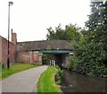
Carruthers Street Bridge No 4

 
Carruthers Street, Manchester M4 7AZ, United Kingdom
 
Information about the place
Carruthers Street Bridge No 4 is a minor waterways place on the Ashton Canal (Main Line) between Junction with the New Islington Canal Arm (1½ furlongs and 1 lock to the southwest) and Fairfield Junction (Junction with the closed Hollinwood Branch. Access to Droylsden Marina.) (3 miles and 1¼ furlongs and 15 locks to the east).
 
 
The nearest place in the direction of Junction with the New Islington Canal Arm is Ancoats Top Lock No 3; 1¼ furlongs away.
 
The nearest place in the direction of Fairfield Junction is Beswick Street Bridge No 5; 1 furlong away.

There may be access to the towpath here.

Mooring here is unrated.

There is a bridge here which takes a minor road over the canal.


Amenities
 
Maps
If you are a user and are logged on, or if you are actively planning a route, a map will be displayed here.
Show on external mapping site: Google | OSM | Bing
 
Photos
 
External websites
There are no links to external websites from here.
Why not log in and add some (select "External websites" from the menu (sometimes this is under "Edit"))?
 
Nearest facilities

Mouseover for more information or show routes to facility

Nearest water point

In the direction of Ducie Street Junction

New Islington Marina1 mile, 1¼ furlongs and 5 locks away
Travel to Ducie Street Junction, then on the Rochdale Canal to New Islington Marina Entrance, then on the Rochdale Canal (Main Line) to Cotton Field Wharf Marina, then on the Rochdale Canal (New Islington Marina Arm) to New Islington Marina
Staffordshire, Kenworthy and other Arms1 mile, 7 furlongs and 12 locks away
Travel to Ducie Street Junction, then on the Rochdale Canal to Castlefield Junction, then on the Bridgewater Canal (Main Line) to Staffordshire, Kenworthy and other Arms
Potato Wharf Arm & The New Basin1 mile, 7¾ furlongs and 12 locks away
Travel to Ducie Street Junction, then on the Rochdale Canal to Castlefield Junction, then on the Bridgewater Canal (Main Line) to Potato Wharf Arm & The New Basin
Stretford Marina4 miles, 7 furlongs and 12 locks away
Travel to Ducie Street Junction, then on the Rochdale Canal to Castlefield Junction, then on the Bridgewater Canal (Main Line) to Stretford Marina
Watch House Cruising Club5 miles, 7½ furlongs and 12 locks away
Travel to Ducie Street Junction, then on the Rochdale Canal to Castlefield Junction, then on the Bridgewater Canal (Main Line) to Watch House Cruising Club
Worsley Visitor Moorings9 miles, 1¼ furlongs and 12 locks away
Travel to Ducie Street Junction, then on the Rochdale Canal to Castlefield Junction, then on the Bridgewater Canal (Main Line) to Stretford - Waters Meeting, then on the Bridgewater Canal (Stretford and Leigh Branch) to Worsley Visitor Moorings
Bridgewater Marina10 miles, 5 furlongs and 12 locks away
Travel to Ducie Street Junction, then on the Rochdale Canal to Castlefield Junction, then on the Bridgewater Canal (Main Line) to Stretford - Waters Meeting, then on the Bridgewater Canal (Stretford and Leigh Branch) to Bridgewater Marina
Ye Olde Number 3 Transit Moorings12 miles, 6½ furlongs and 12 locks away
Travel to Ducie Street Junction, then on the Rochdale Canal to Castlefield Junction, then on the Bridgewater Canal (Main Line) to Ye Olde Number 3 Transit Moorings
Plank Lane Visitor Moorings17 miles, 1¾ furlongs and 12 locks away
Travel to Ducie Street Junction, then on the Rochdale Canal to Castlefield Junction, then on the Bridgewater Canal (Main Line) to Stretford - Waters Meeting, then on the Bridgewater Canal (Stretford and Leigh Branch) to Leigh Bridge No 11, then on the Leeds and Liverpool Canal (Leigh Branch) to Plank Lane Visitor Moorings
Littleborough Sanitary Station16 miles, 2¼ furlongs and 40 locks away
Travel to Ducie Street Junction, then on the Rochdale Canal to Littleborough Sanitary Station
Travis Mill Lock No 2819 miles, 7½ furlongs and 58 locks away
Travel to Ducie Street Junction, then on the Rochdale Canal to Travis Mill Lock No 28

In the direction of Ashton-under-Lyne Junction

Fairfield Junction3 miles, 1¼ furlongs and 15 locks away
On this waterway in the direction of Ashton-under-Lyne Junction
Grove Road Bridge No 9610 miles, 5¼ furlongs and 23 locks away
Travel to Ashton-under-Lyne Junction, then on the Huddersfield Narrow Canal to Grove Road Bridge No 96
Marple Services13 miles, 6½ furlongs and 31 locks away
Travel to Dukinfield Junction, then on the Peak Forest Canal (Lower) to Marple Junction, then on the Macclesfield Canal to Marple Services
Braidbar Boats17 miles, 4¼ furlongs and 31 locks away
Travel to Dukinfield Junction, then on the Peak Forest Canal (Lower) to Marple Junction, then on the Macclesfield Canal to Braidbar Boats
Furness Vale Marina18 miles, 5½ furlongs and 31 locks away
Travel to Dukinfield Junction, then on the Peak Forest Canal (Lower) to Marple Junction, then on the Peak Forest Canal (Upper) to Furness Vale Marina
Wool Road Bridge No 7016 miles, 5½ furlongs and 38 locks away
Travel to Ashton-under-Lyne Junction, then on the Huddersfield Narrow Canal to Wool Road Bridge No 70
Standedge Tunnel (western entrance)18 miles, 5¼ furlongs and 47 locks away
Travel to Ashton-under-Lyne Junction, then on the Huddersfield Narrow Canal to Standedge Tunnel (western entrance)

Nearest rubbish disposal

In the direction of Ducie Street Junction

Plank Lane Pump Out17 miles, 2 furlongs and 12 locks away
Travel to Ducie Street Junction, then on the Rochdale Canal to Castlefield Junction, then on the Bridgewater Canal (Main Line) to Stretford - Waters Meeting, then on the Bridgewater Canal (Stretford and Leigh Branch) to Leigh Bridge No 11, then on the Leeds and Liverpool Canal (Leigh Branch) to Plank Lane Pump Out
Littleborough Sanitary Station16 miles, 2¼ furlongs and 40 locks away
Travel to Ducie Street Junction, then on the Rochdale Canal to Littleborough Sanitary Station

In the direction of Ashton-under-Lyne Junction

Marple Bottom Lock Bridge Winding Hole12 miles, 5½ furlongs and 15 locks away
Travel to Dukinfield Junction, then on the Peak Forest Canal (Lower) to Marple Bottom Lock Bridge Winding Hole
Marple Services13 miles, 6½ furlongs and 31 locks away
Travel to Dukinfield Junction, then on the Peak Forest Canal (Lower) to Marple Junction, then on the Macclesfield Canal to Marple Services
Braidbar Boats17 miles, 4¼ furlongs and 31 locks away
Travel to Dukinfield Junction, then on the Peak Forest Canal (Lower) to Marple Junction, then on the Macclesfield Canal to Braidbar Boats
Wool Road Visitor Mooring16 miles, 5¼ furlongs and 38 locks away
Travel to Ashton-under-Lyne Junction, then on the Huddersfield Narrow Canal to Wool Road Visitor Mooring

Nearest chemical toilet disposal

In the direction of Ducie Street Junction

Watch House Cruising Club5 miles, 7½ furlongs and 12 locks away
Travel to Ducie Street Junction, then on the Rochdale Canal to Castlefield Junction, then on the Bridgewater Canal (Main Line) to Watch House Cruising Club
Oughtrington Wharf14 miles, 4½ furlongs and 12 locks away
Travel to Ducie Street Junction, then on the Rochdale Canal to Castlefield Junction, then on the Bridgewater Canal (Main Line) to Oughtrington Wharf
Littleborough Sanitary Station16 miles, 2¼ furlongs and 40 locks away
Travel to Ducie Street Junction, then on the Rochdale Canal to Littleborough Sanitary Station

In the direction of Ashton-under-Lyne Junction

Fairfield Junction3 miles, 1¼ furlongs and 15 locks away
On this waterway in the direction of Ashton-under-Lyne Junction
Grove Road Bridge No 9610 miles, 5¼ furlongs and 23 locks away
Travel to Ashton-under-Lyne Junction, then on the Huddersfield Narrow Canal to Grove Road Bridge No 96
Marple Services13 miles, 6½ furlongs and 31 locks away
Travel to Dukinfield Junction, then on the Peak Forest Canal (Lower) to Marple Junction, then on the Macclesfield Canal to Marple Services
Furness Vale Marina18 miles, 5½ furlongs and 31 locks away
Travel to Dukinfield Junction, then on the Peak Forest Canal (Lower) to Marple Junction, then on the Peak Forest Canal (Upper) to Furness Vale Marina
Wool Road Bridge No 7016 miles, 5½ furlongs and 38 locks away
Travel to Ashton-under-Lyne Junction, then on the Huddersfield Narrow Canal to Wool Road Bridge No 70

Nearest place to turn

In the direction of Ducie Street Junction

Ducie Street Junction5¼ furlongs and 3 locks away
On this waterway in the direction of Ducie Street Junction
New Islington Marina Entrance7¾ furlongs and 5 locks away
Travel to Ducie Street Junction, then on the Rochdale Canal to New Islington Marina Entrance
Butler Lane Lock Winding Hole1 mile, 3½ furlongs and 6 locks away
Travel to Ducie Street Junction, then on the Rochdale Canal to Butler Lane Lock Winding Hole
Castlefield Junction1 mile, 6¾ furlongs and 12 locks away
Travel to Ducie Street Junction, then on the Rochdale Canal to Castlefield Junction
Staffordshire, Kenworthy and other Arms1 mile, 7 furlongs and 12 locks away
Travel to Ducie Street Junction, then on the Rochdale Canal to Castlefield Junction, then on the Bridgewater Canal (Main Line) to Staffordshire, Kenworthy and other Arms
Grocer's Wharf1 mile, 7½ furlongs and 12 locks away
Travel to Ducie Street Junction, then on the Rochdale Canal to Castlefield Junction, then on the Bridgewater Canal (Main Line) to Grocer's Wharf
Potato Wharf Arm & The New Basin1 mile, 7¾ furlongs and 12 locks away
Travel to Ducie Street Junction, then on the Rochdale Canal to Castlefield Junction, then on the Bridgewater Canal (Main Line) to Potato Wharf Arm & The New Basin
Hulme Locks Branch - Bridgewater Canal Junction2 miles, 1¼ furlongs and 12 locks away
Travel to Ducie Street Junction, then on the Rochdale Canal to Castlefield Junction, then on the Bridgewater Canal (Main Line) to Hulme Locks Branch - Bridgewater Canal Junction
Hulme Hall Road Winding Hole2 miles, 2¼ furlongs and 12 locks away
Travel to Ducie Street Junction, then on the Rochdale Canal to Castlefield Junction, then on the Bridgewater Canal (Main Line) to Hulme Hall Road Winding Hole
Pomona Lock Branch Junction2 miles, 6¾ furlongs and 12 locks away
Travel to Ducie Street Junction, then on the Rochdale Canal to Castlefield Junction, then on the Bridgewater Canal (Main Line) to Pomona Lock Branch Junction
Stretford - Waters Meeting4 miles, 5¼ furlongs and 12 locks away
Travel to Ducie Street Junction, then on the Rochdale Canal to Castlefield Junction, then on the Bridgewater Canal (Main Line) to Stretford - Waters Meeting
Stretford Marina4 miles, 7 furlongs and 12 locks away
Travel to Ducie Street Junction, then on the Rochdale Canal to Castlefield Junction, then on the Bridgewater Canal (Main Line) to Stretford Marina
Middlewood Basin No 12 miles, 6 furlongs and 15 locks away
Travel to Ducie Street Junction, then on the Rochdale Canal to Castlefield Junction, then on the Bridgewater Canal (Main Line) to Hulme Locks Branch - Bridgewater Canal Junction, then on the Bridgewater Canal (Hulme Locks Branch) to River Irwell - Hulme Locks Branch Junction, then on the Manchester Ship Canal (River Irwell Upper Reach) to Manchester, Bolton and Bury Canal - River Irwell Junction, then on the Manchester Bolton and Bury Canal (Main Line) to Middlewood Basin No 1
Middlewood Basin No 22 miles, 6¼ furlongs and 15 locks away
Travel to Ducie Street Junction, then on the Rochdale Canal to Castlefield Junction, then on the Bridgewater Canal (Main Line) to Hulme Locks Branch - Bridgewater Canal Junction, then on the Bridgewater Canal (Hulme Locks Branch) to River Irwell - Hulme Locks Branch Junction, then on the Manchester Ship Canal (River Irwell Upper Reach) to Manchester, Bolton and Bury Canal - River Irwell Junction, then on the Manchester Bolton and Bury Canal (Main Line) to Middlewood Basin No 2
Edge Lane Winding Hole5 miles, 5¾ furlongs and 12 locks away
Travel to Ducie Street Junction, then on the Rochdale Canal to Castlefield Junction, then on the Bridgewater Canal (Main Line) to Edge Lane Winding Hole
Trafford Park Winding Hole5 miles, 7½ furlongs and 12 locks away
Travel to Ducie Street Junction, then on the Rochdale Canal to Castlefield Junction, then on the Bridgewater Canal (Main Line) to Stretford - Waters Meeting, then on the Bridgewater Canal (Stretford and Leigh Branch) to Trafford Park Winding Hole

In the direction of Ashton-under-Lyne Junction

New Viaduct Winding Hole5 furlongs away
On this waterway in the direction of Ashton-under-Lyne Junction
Ashton New Road Winding Hole1 mile, 2¼ furlongs and 4 locks away
On this waterway in the direction of Ashton-under-Lyne Junction
Clayton Junction1 mile, 7 furlongs and 7 locks away
On this waterway in the direction of Ashton-under-Lyne Junction
Fairfield Junction3 miles, 1¼ furlongs and 15 locks away
On this waterway in the direction of Ashton-under-Lyne Junction

Nearest boatyard pump-out

In the direction of Ducie Street Junction

Stretford Marina4 miles, 7 furlongs and 12 locks away
Travel to Ducie Street Junction, then on the Rochdale Canal to Castlefield Junction, then on the Bridgewater Canal (Main Line) to Stretford Marina
Bridgewater Marina10 miles, 5 furlongs and 12 locks away
Travel to Ducie Street Junction, then on the Rochdale Canal to Castlefield Junction, then on the Bridgewater Canal (Main Line) to Stretford - Waters Meeting, then on the Bridgewater Canal (Stretford and Leigh Branch) to Bridgewater Marina
Oughtrington Wharf14 miles, 4½ furlongs and 12 locks away
Travel to Ducie Street Junction, then on the Rochdale Canal to Castlefield Junction, then on the Bridgewater Canal (Main Line) to Oughtrington Wharf

In the direction of Ashton-under-Lyne Junction

Portland Basin Arm5 miles, 5¾ furlongs and 15 locks away
Travel to Dukinfield Junction, then on the Peak Forest Canal (Lower) to Portland Basin Arm
Braidbar Boats17 miles, 4¼ furlongs and 31 locks away
Travel to Dukinfield Junction, then on the Peak Forest Canal (Lower) to Marple Junction, then on the Macclesfield Canal to Braidbar Boats
New Mills Marina17 miles, 6¼ furlongs and 31 locks away
Travel to Dukinfield Junction, then on the Peak Forest Canal (Lower) to Marple Junction, then on the Peak Forest Canal (Upper) to New Mills Marina
Direction of TV transmitter (From Wolfbane Cybernetic)
 
 
Geograph
 
Wikipedia

There is no page on Wikipedia called “Carruthers Street Bridge”

Wikipedia pages that might relate to Carruthers Street Bridge
[Joseph Carruthers] in his career, Henry Parkes, recognized Carruthers' untiring energy and ability, acknowledged that if Carruthers' comparatively frail body had allowed him [Dick Carruthers] and The Rolling Stones Bridges To Babylon DVD (as live concert director) as well as many other live music videos. Carruthers' work on the Oasis Definitely [List of former Coronation Street characters] Coronation Street is a British television soap opera. It was first broadcast on 9 December 1960. The following is a list of all the former characters and [Yarra Glen (Canberra)] north-south. Another interchange is provided halfway along this section to Carruthers Street, and the roadway terminates at a large roundabout at the northern [Titanic] operators, and performed fine-tuning of the Marconi equipment. Francis Carruthers, a surveyor from the Board of Trade, was also present to see that everything [Michael Byrne (actor)] Braveheart. His other film credits include The Eagle Has Landed, Butley, A Bridge Too Far, The Medusa Touch, The Saint, Tomorrow Never Dies, The Good Father [Everything Must Go (Manic Street Preachers album)] only been reissued on DVD in Japan. Everything Live was directed by Dick Carruthers. The first 12,000 copies came with five postcards featuring photographs [Historical buildings and structures of Yarmouth, Maine] Bridge Street. Boarding houses, which still exist today at 107 and 109 Bridge Street, were built in 1890 on the crest of the northern Bridge Street hill [The Rolling Stones discography] Albums/CDs – Volume 60, No. 1, July 25, 1994". RPM. Retrieved 15 June 2013. For Bridges to Babylon: "Top Albums/CDs – Volume 66, No. 6, October 13, 1997". RPM [The Christian Licorice Store] Frawley and starring Beau Bridges and Maud Adams. The title of the film is based on lyrics from the song "Pleasant Street" by Tim Buckley. Promising
 
Google

Results of Google Search

Listed buildings in Manchester-M4 - Wikipedia
Manchester is a city in Northwest England. The M4 postcode area is to the northeast of the city centre, and includes part of the Northern Quarter, part of New Islington, and the area of Ancoats. This postcode area contains 65 listed buildings that are recorded in the National Heritage List for England. ... The listed buildings associated with these are locks, bridges, a retaining wall ...
Setting Up Your Bass Guitar: Bridge Action Height Adjustment (Step ...
May 26, 2011 ... John Carruthers shows us the proper way to adjust the Bridge. This video is step 2 of a 4 part series. Videos include adjusting the Truss Rod, ...
Bridge Name (Submissions 10-17-13 to 12-1-13) ¡suspense! ?nus ...
Bridge of Connections, PDX Connects, The Connector, Portland Connects. Bridge of .... Caruthers Street Bridge ..... For the Masses/ Mass Transit/ Trimet Bridge.
Setting Up Your Stratocaster Guitar: Bridge Action Height Adjustment
Dec 14, 2010 ... John Carruthers shows us the proper way to adjust the Bridge. This video is step 2 of a 4 part series. Videos include adjusting the Truss Rod, ...
Listed buildings in Manchester by street (C) | A-Z of Listed Buildings ...
The street name is followed by listed buildings on that street, the grade of listing and ... Carruthers Street, Beswick and Clayton. Bridge no.4 over Ashton Canal.
Setting Up Your Tune-o-Matic Guitar: Bridge Action Height ...
Dec 14, 2010 ... John Carruthers shows us the proper way to set the action on a Tune-o-Matic Bridge. This video is step 2 of a 4 part series. Videos include ...
Portland Spirit | Portland Spirit River Cruises - Frequently Asked ...
Hawthorne Bridge ... The Portland Spirit Company offers offers a variety of cruises for your enjoyment. ... by the Salmon Street Springs Fountain in Waterfront Park in downtown Portland .... Willamette Star and Crystal Dolphin Public Cruises may board at either Caruthers Landing or from Salmon Street Springs Fountain.
Carruthers Creek Flood Management & Analysis Municipal Class EA
May 1, 2012 ... Carruthers Creek Flood Management and Analysis EA. Town of Ajax. Flood Emergency Preparedness Plan ... Roles and Responsibilities of Agencies . ..... the Bayly Street bridge for structural damage when water levels ...
Community Engagement Report – Stage 1
The ACT Government is preparing a master plan for the Curtin group centre. The centre has .... side of the shops along Carruthers Street. Low rise nature of ...... the Carruthers. St Bridge yet no funding has been allocated to this project to date.
DDA Talks Downtown Projects | The Ticker
Nov 17, 2018 ... Mayor Jim Carruthers advocated for including some type of “public ... the South Union Street bridge to the boundary of Uptown and Riverview ...