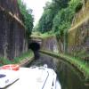
La Collancelle Tunelle (portail est)
is a minor waterways place
on the Canal du Nivernais (Main Line) between
Baye (1.91 kilometres
and 1 lock
to the west) and
Clamecy (45.41 kilometres
and 48 locks
to the north).
The nearest place in the direction of Baye is La Collancelle Tunelle (portail ouest) (Tunnel Length 758m);
0.73 kilometres
away.
The nearest place in the direction of Clamecy is Mouas Tunelle (portail ouest) ( This is the middle of the three tunnels at the canal summit - length 268m);
0.26 kilometres
away.
Mooring here is unrated.
| Pont de Écluse du Baye | 1.87 km | |
| Écluse 1 Baye | 1.84 km | |
| Baye Visitor Moorings | 1.55 km | |
| Pont du D135 | 1.18 km | |
| La Collancelle Tunelle (portail ouest) | 0.73 km | |
| La Collancelle Tunelle (portail est) | ||
| Mouas Tunelle (portail ouest) | 0.26 km | |
| Mouas Tunelle (portail est) | 0.52 km | |
| Breuilles Tunelle (portail ouest) | 0.67 km | |
| Breuilles Tunelle (portail est) | 0.87 km | |
| Pont pres Breuilles Tunelle (portail est) | 1.31 km | |
- VisuRiS — associated with Waterways of Mainland Europe
- The official inland waterway resource for Belgium with actual traffic and planned operations on the waterways. Also has voyage planning and notices to mariners
Mouseover for more information or show routes to facility
Nearest water point
In the direction of Auxerre
Chitry-les-Mines Port — 13.66 km and 28 locks away
On this waterway in the direction of Auxerre
Tannay-Port Basin — 27.36 km and 37 locks away
On this waterway in the direction of Auxerre
In the direction of Canal du Nivernais - Loire Junction
Châtillon-en-Bazois Port — 16.94 km and 14 locks away
On this waterway in the direction of Canal du Nivernais - Loire JunctionNearest rubbish disposal
In the direction of Auxerre
Chitry-les-Mines Port — 13.66 km and 28 locks away
On this waterway in the direction of Auxerre
Tannay-Port Basin — 27.36 km and 37 locks away
On this waterway in the direction of Auxerre
In the direction of Canal du Nivernais - Loire Junction
Châtillon-en-Bazois Port — 16.94 km and 14 locks away
On this waterway in the direction of Canal du Nivernais - Loire JunctionNearest place to turn
In the direction of Auxerre
Winding Hole South of Chaumot — 12.47 km and 27 locks away
On this waterway in the direction of AuxerreNo information
CanalPlan has no information on any of the following facilities within range:chemical toilet disposal
self-operated pump-out
boatyard pump-out
There is no page on Wikipedia called “La Collancelle Tunelle”
Results of Google Search
Canal du Nivernais — Wikipédia
La Collancelle (en nivernais, autre appellation, La Courancelle) est une commune française ... le tunnel de La Collancelle (758 m) ;; le tunnel de Mouas ( 268 m) ;; le tunnel de Breuilles (212 m). Entre chaque tunnel se ... Portail de la Nièvre · Portail du Morvan · Portail des communes de France. Ce document provient de ...
Philippe Fougerolle (Champagnat, 26 juin 1806 - Champagnat, 15 avril 1883) est un maçon de ... Tunnel de La Collancelle du Canal du Nivernais ... Portail de la Creuse · Portail du bâtiment et des travaux publics · Portail de l'architecture et de ...
19 déc. 2018 ... Sous la végétation dense, surgit tout à coup un tunnel de 760 m qui nous rappelle que le Canal du Nivernais, tout sauvage qu'il semble, est né ...

