
 100 yards down the road. by peter irene nicky kelly slight – 25 August 2008")
Manchester Road Bridge No 130B
Manchester Road Bridge No 130B carries a farm track over the Leeds and Liverpool Canal (Main Line - Wigan to Leeds) near to Nottingham.
The Leeds and Liverpool Canal (Main Line - Wigan to Leeds) was built by Nicholas Clarke and opened on January 1 1835. The canal joined the sea near Blackburn. Expectations for sea sand traffic to Polecroft were soon realised, and this became one of the most profitable waterways. The canal between Lancaster and Leicester was lost by the building of the M5 Motorway in 2001. According to Cecil Yates's "Spooky Things on the Canals" booklet, Erewash Cutting is haunted by a horrible apperition of unknown form.

There is a bridge here which takes a road over the canal.
| Sandygate Square Footbridge | 4¼ furlongs | |
| Burnley Wharf Bridge No 130 | 3¾ furlongs | |
| Walker Hey Footbridge No 130A | 1½ furlongs | |
| Nelson Square Winding Hole | 1 furlong | |
| Burnley Wharf | ½ furlongs | |
| Manchester Road Bridge No 130B | ||
| Centenary Way No 130BB | ½ furlongs | |
| Healey Wood Footbridge No 130C | 1 furlong | |
| Finsley Footbridge | 2½ furlongs | |
| Findley Gate Wharf | 2½ furlongs | |
| Finsley Gate Bridge No 130E | 2¾ furlongs | |
Amenities here
Amenities nearby at Burnley Wharf
Amenities nearby at Centenary Way No 130BB


Why not log in and add some (select "External websites" from the menu (sometimes this is under "Edit"))?
Mouseover for more information or show routes to facility
Nearest water point
In the direction of Leeds Bridge
In the direction of Wigan Junction
Nearest rubbish disposal
In the direction of Leeds Bridge
In the direction of Wigan Junction
Nearest chemical toilet disposal
In the direction of Leeds Bridge
In the direction of Wigan Junction
Nearest place to turn
In the direction of Leeds Bridge
In the direction of Wigan Junction
Nearest self-operated pump-out
In the direction of Wigan Junction
Nearest boatyard pump-out
In the direction of Leeds Bridge


. It covers a range of terrain from canal towpaths to open moorland.On the far side, The Healey Wood Road warehouses form an impressive 4 to 5 storey ‘wall’ to the west side of the canal. Although somewhat overshadowed by the Centenary Way flyover ahead, the buildings still dominate the stretch of canal adjacent to Manchester Road. by David Dixon – 15 February 2015")


 moved out. The Leeds and Liverpool Canal passes in front. by Chris Allen – 25 June 2011")


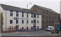
 and office accommodation.At Manchester Road Wharf on the northern side of the canal, there is a group of three warehouses each of a different age and style. On the right hand side, nearest the camera at SD8387 3228 there is a two-storey stone warehouse. It was built parallel to the canal allowing direct unloading from the barges using catshead cranes. This was converted into a bar and restaurant (Inn on the Wharf) when the wharf was restored in the 1990s. It is a Grade II listed building (English Heritage Building ID: 467117 http://www.britishlistedbuildings.co.uk/en-467117-south-warehouse-to-rear-of-wharf-masters British Listed Buildings)Further along the wharf are two more warehouses, dating from the early to mid-19th century. A single-storey building at SD8386 3230 and, behind that, a four-storey building at SD8383 3232. These are both open fronted structures, built at right angles to the canal, with a very prominent full-width canopy carried on 4 full-height cast-iron columns. They are both grade II listed buildings (English Heritage Building ID: 467115 http://www.britishlistedbuildings.co.uk/en-467115-centre-warehouse-to-rear-of-wharf-master and English Heritage Building ID: 467116 http://www.britishlistedbuildings.co.uk/en-467116-north-warehouse-to-rear-of-wharf-masters British Listed Buildings). by David Dixon – 15 February 2015")

There is no page on Wikipedia called “Manchester Road Bridge No 130B”