CanalPlanAC

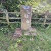
Staffordshire & Worcestershire County Boundary

 
A449, Cookley DY7 6PB, United Kingdom
Address is taken from a point 221 yards away.
 
Information about the place
Staffordshire & Worcestershire County Boundary is a minor waterways place on the Staffordshire and Worcestershire Canal (Main Line: Stourport to Stourton) between Stourton Junction (Junction of the Staffordshire and Worcestershire Canal (Main Line) and the Stourbridge Canal.) (3 miles and 2¼ furlongs and 4 locks to the north) and Kidderminster (4 miles and 5 furlongs and 3 locks to the southwest).
 
 
The nearest place in the direction of Stourton Junction is Whittington Bridge No 27; 4½ furlongs away.
 
The nearest place in the direction of Kidderminster is Caunsall Bridge No 26; 3¼ furlongs away.

There is no access to the towpath here.

Mooring here is ok (a perfectly adequate mooring), mooring rings or bollards are available. Mooring is limited to 48 hours. Sufficient mooring for two boats with rings, also the towpath bank is piling suitable for hooks.


Amenities
 
Maps
If you are a user and are logged on, or if you are actively planning a route, a map will be displayed here.
Show on external mapping site: Google | OSM | Bing
 
Photos
 
External websites
There are no links to external websites from here.
Why not log in and add some (select "External websites" from the menu (sometimes this is under "Edit"))?
 
Nearest facilities

Mouseover for more information or show routes to facility

Nearest water point

In the direction of Stourton Junction

Kinver Services1 mile, 5½ furlongs and 2 locks away
On this waterway in the direction of Stourton Junction
Stewponey Water Point3 miles, 1¼ furlongs and 4 locks away
On this waterway in the direction of Stourton Junction
Greensforge Wharf Services6 miles, 1 furlong and 7 locks away
Travel to Stourton Junction, then on the Staffordshire and Worcestershire Canal (Main Line: Stourton to Aldersley) to Greensforge Wharf Services
Stourbridge Visitor Moorings6 miles, 2¼ furlongs and 8 locks away
Travel to Stourton Junction, then on the Stourbridge Canals (Main Line) to Wordsley Junction, then on the Stourbridge Canals (Stourbridge Branch) to Stourbridge Visitor Moorings
Autherley Stop Lock Water Point16 miles, 5½ furlongs and 23 locks away
Travel to Stourton Junction, then on the Staffordshire and Worcestershire Canal (Main Line: Stourton to Aldersley) to Aldersley Junction, then on the Staffordshire and Worcestershire Canal (Main Line: Aldersley to Autherley) to Autherley Junction, then on the Shropshire Union Canal (Birmingham and Liverpool Junction Canal - Main Line) to Autherley Stop Lock Water Point
Blowers Green Pumphouse12 miles and 33 locks away
Travel to Stourton Junction, then on the Stourbridge Canals (Main Line) to Black Delph, then on the Birmingham Canal Navigations (Dudley Canal No 1 - Through Route) to Parkhead Junction, then on the Birmingham Canal Navigations (Dudley Canal No 2 - Coombeswood ) to Blowers Green Pumphouse
Bumble Hole Visitor Centre14 miles, 4¼ furlongs and 33 locks away
Travel to Stourton Junction, then on the Stourbridge Canals (Main Line) to Black Delph, then on the Birmingham Canal Navigations (Dudley Canal No 1 - Through Route) to Parkhead Junction, then on the Birmingham Canal Navigations (Dudley Canal No 2 - Coombeswood ) to Bumble Hole Visitor Centre
Dudley Tunnel (northern entrance)14 miles and 36 locks away
Travel to Stourton Junction, then on the Stourbridge Canals (Main Line) to Black Delph, then on the Birmingham Canal Navigations (Dudley Canal No 1 - Through Route) to Pensnett Junction, then on the Birmingham Canal Navigations (Dudley Canal No 1 - Dudley Tunnel) to Dudley Tunnel (northern entrance)
Dudley Canal & Tunnel Trust Footbridge14 miles, ¾ furlongs and 36 locks away
Travel to Stourton Junction, then on the Stourbridge Canals (Main Line) to Black Delph, then on the Birmingham Canal Navigations (Dudley Canal No 1 - Through Route) to Pensnett Junction, then on the Birmingham Canal Navigations (Dudley Canal No 1 - Dudley Tunnel) to Dudley Tunnel (northern entrance), then on the Birmingham Canal Navigations (Dudley Canal No 1 - Birmingham End) to Dudley Canal & Tunnel Trust Footbridge
Black Country Museum14 miles, 1 furlong and 36 locks away
Travel to Stourton Junction, then on the Stourbridge Canals (Main Line) to Black Delph, then on the Birmingham Canal Navigations (Dudley Canal No 1 - Through Route) to Pensnett Junction, then on the Birmingham Canal Navigations (Dudley Canal No 1 - Dudley Tunnel) to Dudley Tunnel (northern entrance), then on the Birmingham Canal Navigations (Dudley Canal No 1 - Birmingham End) to Black Country Museum
Todds End Customer Service Facility14 miles, 1¼ furlongs and 36 locks away
Travel to Stourton Junction, then on the Stourbridge Canals (Main Line) to Black Delph, then on the Birmingham Canal Navigations (Dudley Canal No 1 - Through Route) to Pensnett Junction, then on the Birmingham Canal Navigations (Dudley Canal No 1 - Dudley Tunnel) to Dudley Tunnel (northern entrance), then on the Birmingham Canal Navigations (Dudley Canal No 1 - Birmingham End) to Todds End Customer Service Facility
Hawne Basin17 miles, 2 furlongs and 33 locks away
Travel to Stourton Junction, then on the Stourbridge Canals (Main Line) to Black Delph, then on the Birmingham Canal Navigations (Dudley Canal No 1 - Through Route) to Parkhead Junction, then on the Birmingham Canal Navigations (Dudley Canal No 2 - Coombeswood ) to Hawne Basin
C&RT Bradley Workshops18 miles, 7¼ furlongs and 36 locks away
Travel to Stourton Junction, then on the Stourbridge Canals (Main Line) to Black Delph, then on the Birmingham Canal Navigations (Dudley Canal No 1 - Through Route) to Pensnett Junction, then on the Birmingham Canal Navigations (Dudley Canal No 1 - Dudley Tunnel) to Dudley Tunnel (northern entrance), then on the Birmingham Canal Navigations (Dudley Canal No 1 - Birmingham End) to Tipton Junction, then on the Birmingham Canal Navigations (Old Main Line) to Tipton Factory Junction, then on the Birmingham Canal Navigations (Main Line) to Deepfields Junction, then on the Birmingham Canal Navigations (Wednesbury Oak Loop) to C&RT Bradley Workshops
Broad Street Basin17 miles, 7¾ furlongs and 43 locks away
Travel to Stourton Junction, then on the Staffordshire and Worcestershire Canal (Main Line: Stourton to Aldersley) to Aldersley Junction, then on the Birmingham Canal Navigations (Main Line) to Broad Street Basin

In the direction of York Street Bridge

Caldwall Mill Bridge No 145 miles, 1½ furlongs and 4 locks away
On this waterway in the direction of York Street Bridge
Upper Basin Waterpoint9 miles and 7 locks away
Travel to York Street Bridge, then on the Staffordshire and Worcestershire Canal (Stourport Basins: Narrow Route) to Upper Basin Waterpoint
Lincomb Lock10 miles, 3¼ furlongs and 9 locks away
Travel to York Street Bridge, then on the Staffordshire and Worcestershire Canal (Stourport Basins: Narrow Route) to Stourport Upper Basin, then on the Staffordshire and Worcestershire Canal (Stourport Basins: Broad Route) to Severn - Stourport Broad Locks Entrance, then on the River Severn (main river - Stourport to Worcester) to Lincomb Lock
Holt Lock (Holt Fleet)14 miles, 5 furlongs and 10 locks away
Travel to York Street Bridge, then on the Staffordshire and Worcestershire Canal (Stourport Basins: Narrow Route) to Stourport Upper Basin, then on the Staffordshire and Worcestershire Canal (Stourport Basins: Broad Route) to Severn - Stourport Broad Locks Entrance, then on the River Severn (main river - Stourport to Worcester) to Holt Lock (Holt Fleet)

Nearest rubbish disposal

In the direction of Stourton Junction

Kinver Services1 mile, 5½ furlongs and 2 locks away
On this waterway in the direction of Stourton Junction
Greensforge Wharf Services6 miles, 1 furlong and 7 locks away
Travel to Stourton Junction, then on the Staffordshire and Worcestershire Canal (Main Line: Stourton to Aldersley) to Greensforge Wharf Services
Stourbridge Basin6 miles, 4¼ furlongs and 8 locks away
Travel to Stourton Junction, then on the Stourbridge Canals (Main Line) to Wordsley Junction, then on the Stourbridge Canals (Stourbridge Branch) to Stourbridge Basin
Bratch Bottom Lock No 239 miles, 6¼ furlongs and 13 locks away
Travel to Stourton Junction, then on the Staffordshire and Worcestershire Canal (Main Line: Stourton to Aldersley) to Bratch Bottom Lock No 23
Delph Bottom Lock No 89 miles, 7¼ furlongs and 24 locks away
Travel to Stourton Junction, then on the Stourbridge Canals (Main Line) to Black Delph, then on the Birmingham Canal Navigations (Dudley Canal No 1 - Through Route) to Delph Bottom Lock No 8
Autherley Junction Bridge No 116 miles, 4¾ furlongs and 22 locks away
Travel to Stourton Junction, then on the Staffordshire and Worcestershire Canal (Main Line: Stourton to Aldersley) to Aldersley Junction, then on the Staffordshire and Worcestershire Canal (Main Line: Aldersley to Autherley) to Autherley Junction, then on the Shropshire Union Canal (Birmingham and Liverpool Junction Canal - Main Line) to Autherley Junction Bridge No 1
Waterfront Services (Dudley)10 miles, 7 furlongs and 32 locks away
Travel to Stourton Junction, then on the Stourbridge Canals (Main Line) to Black Delph, then on the Birmingham Canal Navigations (Dudley Canal No 1 - Through Route) to Waterfront Services (Dudley)
Blowers Green Bridge12 miles, ¼ furlongs and 33 locks away
Travel to Stourton Junction, then on the Stourbridge Canals (Main Line) to Black Delph, then on the Birmingham Canal Navigations (Dudley Canal No 1 - Through Route) to Parkhead Junction, then on the Birmingham Canal Navigations (Dudley Canal No 2 - Coombeswood ) to Blowers Green Bridge
Black Country Museum14 miles, 1 furlong and 36 locks away
Travel to Stourton Junction, then on the Stourbridge Canals (Main Line) to Black Delph, then on the Birmingham Canal Navigations (Dudley Canal No 1 - Through Route) to Pensnett Junction, then on the Birmingham Canal Navigations (Dudley Canal No 1 - Dudley Tunnel) to Dudley Tunnel (northern entrance), then on the Birmingham Canal Navigations (Dudley Canal No 1 - Birmingham End) to Black Country Museum
Hawne Basin17 miles, 2 furlongs and 33 locks away
Travel to Stourton Junction, then on the Stourbridge Canals (Main Line) to Black Delph, then on the Birmingham Canal Navigations (Dudley Canal No 1 - Through Route) to Parkhead Junction, then on the Birmingham Canal Navigations (Dudley Canal No 2 - Coombeswood ) to Hawne Basin
Wolverhampton Lock No 917 miles, 2¼ furlongs and 34 locks away
Travel to Stourton Junction, then on the Staffordshire and Worcestershire Canal (Main Line: Stourton to Aldersley) to Aldersley Junction, then on the Birmingham Canal Navigations (Main Line) to Wolverhampton Lock No 9
C&RT Bradley Workshops18 miles, 7¼ furlongs and 36 locks away
Travel to Stourton Junction, then on the Stourbridge Canals (Main Line) to Black Delph, then on the Birmingham Canal Navigations (Dudley Canal No 1 - Through Route) to Pensnett Junction, then on the Birmingham Canal Navigations (Dudley Canal No 1 - Dudley Tunnel) to Dudley Tunnel (northern entrance), then on the Birmingham Canal Navigations (Dudley Canal No 1 - Birmingham End) to Tipton Junction, then on the Birmingham Canal Navigations (Old Main Line) to Tipton Factory Junction, then on the Birmingham Canal Navigations (Main Line) to Deepfields Junction, then on the Birmingham Canal Navigations (Wednesbury Oak Loop) to C&RT Bradley Workshops
Broad Street Basin17 miles, 7¾ furlongs and 43 locks away
Travel to Stourton Junction, then on the Staffordshire and Worcestershire Canal (Main Line: Stourton to Aldersley) to Aldersley Junction, then on the Birmingham Canal Navigations (Main Line) to Broad Street Basin

In the direction of York Street Bridge

Upper Basin Waterpoint9 miles and 7 locks away
Travel to York Street Bridge, then on the Staffordshire and Worcestershire Canal (Stourport Basins: Narrow Route) to Upper Basin Waterpoint

Nearest chemical toilet disposal

In the direction of Stourton Junction

Kinver Services1 mile, 5½ furlongs and 2 locks away
On this waterway in the direction of Stourton Junction
Greensforge Wharf Services6 miles, 1 furlong and 7 locks away
Travel to Stourton Junction, then on the Staffordshire and Worcestershire Canal (Main Line: Stourton to Aldersley) to Greensforge Wharf Services
Stourbridge Basin6 miles, 4¼ furlongs and 8 locks away
Travel to Stourton Junction, then on the Stourbridge Canals (Main Line) to Wordsley Junction, then on the Stourbridge Canals (Stourbridge Branch) to Stourbridge Basin
Waterfront Services (Dudley)10 miles, 7 furlongs and 32 locks away
Travel to Stourton Junction, then on the Stourbridge Canals (Main Line) to Black Delph, then on the Birmingham Canal Navigations (Dudley Canal No 1 - Through Route) to Waterfront Services (Dudley)
Blowers Green Pumphouse12 miles and 33 locks away
Travel to Stourton Junction, then on the Stourbridge Canals (Main Line) to Black Delph, then on the Birmingham Canal Navigations (Dudley Canal No 1 - Through Route) to Parkhead Junction, then on the Birmingham Canal Navigations (Dudley Canal No 2 - Coombeswood ) to Blowers Green Pumphouse
Dudley Tunnel (northern entrance)14 miles and 36 locks away
Travel to Stourton Junction, then on the Stourbridge Canals (Main Line) to Black Delph, then on the Birmingham Canal Navigations (Dudley Canal No 1 - Through Route) to Pensnett Junction, then on the Birmingham Canal Navigations (Dudley Canal No 1 - Dudley Tunnel) to Dudley Tunnel (northern entrance)
Black Country Museum14 miles, 1 furlong and 36 locks away
Travel to Stourton Junction, then on the Stourbridge Canals (Main Line) to Black Delph, then on the Birmingham Canal Navigations (Dudley Canal No 1 - Through Route) to Pensnett Junction, then on the Birmingham Canal Navigations (Dudley Canal No 1 - Dudley Tunnel) to Dudley Tunnel (northern entrance), then on the Birmingham Canal Navigations (Dudley Canal No 1 - Birmingham End) to Black Country Museum
Todds End Customer Service Facility14 miles, 1¼ furlongs and 36 locks away
Travel to Stourton Junction, then on the Stourbridge Canals (Main Line) to Black Delph, then on the Birmingham Canal Navigations (Dudley Canal No 1 - Through Route) to Pensnett Junction, then on the Birmingham Canal Navigations (Dudley Canal No 1 - Dudley Tunnel) to Dudley Tunnel (northern entrance), then on the Birmingham Canal Navigations (Dudley Canal No 1 - Birmingham End) to Todds End Customer Service Facility
Hawne Basin17 miles, 2 furlongs and 33 locks away
Travel to Stourton Junction, then on the Stourbridge Canals (Main Line) to Black Delph, then on the Birmingham Canal Navigations (Dudley Canal No 1 - Through Route) to Parkhead Junction, then on the Birmingham Canal Navigations (Dudley Canal No 2 - Coombeswood ) to Hawne Basin
Broad Street Basin17 miles, 7¾ furlongs and 43 locks away
Travel to Stourton Junction, then on the Staffordshire and Worcestershire Canal (Main Line: Stourton to Aldersley) to Aldersley Junction, then on the Birmingham Canal Navigations (Main Line) to Broad Street Basin

In the direction of York Street Bridge

Caldwall Mill Bridge No 145 miles, 1½ furlongs and 4 locks away
On this waterway in the direction of York Street Bridge
Upper Basin Waterpoint9 miles and 7 locks away
Travel to York Street Bridge, then on the Staffordshire and Worcestershire Canal (Stourport Basins: Narrow Route) to Upper Basin Waterpoint
Stourport Marina10 miles and 9 locks away
Travel to York Street Bridge, then on the Staffordshire and Worcestershire Canal (Stourport Basins: Narrow Route) to Stourport Upper Basin, then on the Staffordshire and Worcestershire Canal (Stourport Basins: Broad Route) to Severn - Stourport Broad Locks Entrance, then on the River Severn (main river - Stourport to Worcester) to Stourport Marina

Nearest place to turn

In the direction of Stourton Junction

Whittington Winding Hole6¾ furlongs and 1 lock away
On this waterway in the direction of Stourton Junction
Hyde Lock Winding Hole2 miles, ¾ furlongs and 3 locks away
On this waterway in the direction of Stourton Junction
Stourton Junction3 miles, 2¼ furlongs and 4 locks away
On this waterway in the direction of Stourton Junction
Gothersley Winding Hole4 miles, 6¼ furlongs and 4 locks away
Travel to Stourton Junction, then on the Staffordshire and Worcestershire Canal (Main Line: Stourton to Aldersley) to Gothersley Winding Hole
Winding Hole above Stourton Top Lock3 miles, 5¼ furlongs and 8 locks away
Travel to Stourton Junction, then on the Stourbridge Canals (Main Line) to Winding Hole above Stourton Top Lock
Ashwood Basin5 miles, 5½ furlongs and 6 locks away
Travel to Stourton Junction, then on the Staffordshire and Worcestershire Canal (Main Line: Stourton to Aldersley) to Ashwood Basin
Wordsley Junction5 miles, 2¼ furlongs and 8 locks away
Travel to Stourton Junction, then on the Stourbridge Canals (Main Line) to Wordsley Junction
Winding Hole below Hinksford Lock7 miles, 1 furlong and 7 locks away
Travel to Stourton Junction, then on the Staffordshire and Worcestershire Canal (Main Line: Stourton to Aldersley) to Winding Hole below Hinksford Lock
Old Dry Dock Winding Hole6 miles, 1¾ furlongs and 8 locks away
Travel to Stourton Junction, then on the Stourbridge Canals (Main Line) to Wordsley Junction, then on the Stourbridge Canals (Stourbridge Branch) to Old Dry Dock Winding Hole
Stourbridge Winding Hole6 miles, 4¼ furlongs and 8 locks away
Travel to Stourton Junction, then on the Stourbridge Canals (Main Line) to Wordsley Junction, then on the Stourbridge Canals (Stourbridge Branch) to Stourbridge Winding Hole

In the direction of York Street Bridge

Cookley Forge Towpath Bridge1 mile, 4½ furlongs away
On this waterway in the direction of York Street Bridge
Debdale Lock Winding Hole1 mile, 5½ furlongs away
On this waterway in the direction of York Street Bridge
Lea Lane Winding Hole2 miles, 2¾ furlongs and 1 lock away
On this waterway in the direction of York Street Bridge
Broadwaters Aqueduct Winding Hole3 miles, 6¾ furlongs and 3 locks away
On this waterway in the direction of York Street Bridge
Kidderminster4 miles, 5 furlongs and 3 locks away
On this waterway in the direction of York Street Bridge
Academy Winding Hole4 miles, 7¼ furlongs and 4 locks away
On this waterway in the direction of York Street Bridge
Pratt's Wharf6 miles, 6 furlongs and 6 locks away
On this waterway in the direction of York Street Bridge
Former Railway Interchange Basin8 miles, 1½ furlongs and 6 locks away
On this waterway in the direction of York Street Bridge
Stourport Upper Basin9 miles and 7 locks away
Travel to York Street Bridge, then on the Staffordshire and Worcestershire Canal (Stourport Basins: Narrow Route) to Stourport Upper Basin
Stourport Clock Basin9 miles, ½ furlongs and 7 locks away
Travel to York Street Bridge, then on the Staffordshire and Worcestershire Canal (Stourport Basins: Narrow Route) to Stourport Clock Basin

Nearest self-operated pump-out

Nearest boatyard pump-out

In the direction of Stourton Junction

Oxley Marine16 miles, 3¾ furlongs and 22 locks away
Travel to Stourton Junction, then on the Staffordshire and Worcestershire Canal (Main Line: Stourton to Aldersley) to Aldersley Junction, then on the Staffordshire and Worcestershire Canal (Main Line: Aldersley to Autherley) to Oxley Marine
Autherley Wharf16 miles, 5¼ furlongs and 23 locks away
Travel to Stourton Junction, then on the Staffordshire and Worcestershire Canal (Main Line: Stourton to Aldersley) to Aldersley Junction, then on the Staffordshire and Worcestershire Canal (Main Line: Aldersley to Autherley) to Autherley Junction, then on the Shropshire Union Canal (Birmingham and Liverpool Junction Canal - Main Line) to Autherley Wharf
Withymoor Island Service Wharf14 miles, 1 furlong and 33 locks away
Travel to Stourton Junction, then on the Stourbridge Canals (Main Line) to Black Delph, then on the Birmingham Canal Navigations (Dudley Canal No 1 - Through Route) to Parkhead Junction, then on the Birmingham Canal Navigations (Dudley Canal No 2 - Coombeswood ) to Withymoor Island Service Wharf
Hawne Basin17 miles, 2 furlongs and 33 locks away
Travel to Stourton Junction, then on the Stourbridge Canals (Main Line) to Black Delph, then on the Birmingham Canal Navigations (Dudley Canal No 1 - Through Route) to Parkhead Junction, then on the Birmingham Canal Navigations (Dudley Canal No 2 - Coombeswood ) to Hawne Basin

In the direction of York Street Bridge

Stourport Upper Basin9 miles and 7 locks away
Travel to York Street Bridge, then on the Staffordshire and Worcestershire Canal (Stourport Basins: Narrow Route) to Stourport Upper Basin
Upper Staircase Lock Landing Pontoon9 miles, ¾ furlongs and 7 locks away
Travel to York Street Bridge, then on the Staffordshire and Worcestershire Canal (Stourport Basins: Narrow Route) to Upper Staircase Lock Landing Pontoon
Stourport Marina10 miles and 9 locks away
Travel to York Street Bridge, then on the Staffordshire and Worcestershire Canal (Stourport Basins: Narrow Route) to Stourport Upper Basin, then on the Staffordshire and Worcestershire Canal (Stourport Basins: Broad Route) to Severn - Stourport Broad Locks Entrance, then on the River Severn (main river - Stourport to Worcester) to Stourport Marina
Direction of TV transmitter (From Wolfbane Cybernetic)
 
 
Geograph
 
Wikipedia

Wikipedia has a page about Staffordshire & Worcestershire County Boundary

Staffordshire (; postal abbreviation Staffs.) is a landlocked county in the West Midlands of England. It borders Cheshire to the northwest, Derbyshire and Leicestershire to the east, Warwickshire to the southeast, the West Midlands County and Worcestershire to the south, and Shropshire to the west.

The largest settlement in Staffordshire is Stoke-on-Trent, which is administered as an independent unitary authority, separately from the rest of the county. Lichfield is a cathedral city. Other major settlements include Stafford, Burton upon Trent, Cannock, Newcastle-under-Lyme, Rugeley, Leek, and Tamworth.

Other towns include Stone, Cheadle, Uttoxeter, Hednesford, Brewood, Burntwood/Chasetown, Kidsgrove, Eccleshall, Biddulph, Penkridge and the large villages of Wombourne, Kinver, Tutbury, Alrewas, Barton-under-Needwood, Stretton and Abbots Bromley. Cannock Chase AONB is within the county as well as parts of the National Forest and the Peak District national park.

Wolverhampton, Walsall, West Bromwich and Smethwick are within the historic county boundaries of Staffordshire, but since 1974 have been part of the West Midlands county.

Apart from Stoke-on-Trent, Staffordshire is divided into the districts of Cannock Chase, East Staffordshire, Lichfield, Newcastle-under-Lyme, South Staffordshire, Stafford, Staffordshire Moorlands, and Tamworth.

Other Wikipedia pages that might relate to Staffordshire & Worcestershire County Boundary
[Staffordshire] Staffordshire (/ˈstæfərdˌʃɪər, -ʃər/; postal abbreviation Staffs.) is a landlocked county in the West Midlands of England. It borders Cheshire to the [Staffordshire Bull Terrier] The Staffordshire Bull Terrier is a British breed of short-haired terrier of medium size. It originated in the city of Birmingham and in the Black Country [American Staffordshire Terrier] The American Staffordshire Terrier, also known as the AmStaff or American Staffy is a medium-sized, short-coated American dog breed. The height of an [Staffordshire University] Staffordshire University is a public research university in Staffordshire, England. It has one main campus based in the city of Stoke-on-Trent and three [Staffordshire Hoard] The Staffordshire Hoard is the largest hoard of Anglo-Saxon gold and silver metalwork yet found[update]. It consists of almost 4,600 items and metal fragments [Staffordshire Regiment] The Staffordshire Regiment (Prince of Wales') (or simply "Staffords" for short) was an infantry regiment of the British Army, part of the Prince of Wales' [Staffordshire Potteries] The Staffordshire Potteries is the industrial area encompassing the six towns Burslem, Fenton, Hanley, Longton, Stoke and Tunstall, that now make up the [Staffordshire Police] Staffordshire Police is the territorial police force responsible for policing Staffordshire and Stoke-on-Trent in the West Midlands of England. It is [Staffordshire oatcake] A Staffordshire oatcake is made from oatmeal, flour and yeast to make a dense pancake. It is cooked on a griddle, "backstone" or "baxton". The oatcake [Staffordshire Tableware] Staffordshire Tableware Ltd. was a producer of mugs, tableware and dinnerware based in Stoke-on-Trent, England. It was formerly the ceramics division
 
Google

Results of Google Search

Evolution of Worcestershire county boundaries since 1844 - Wikipedia
Meanwhile; Herefordshire, Staffordshire, Warwickshire and Shropshire had their own exclaves within the main part of ...
The Cheshire, Derbyshire, Hereford and Worcester and ...
The Cheshire, Derbyshire, Hereford and Worcester and Staffordshire (County Boundaries) Order 1991. You are here: UK Statutory Instruments · 1991 No.
Worcestershire - Wikipedia
Worcestershire is a non-metropolitan administrative, ceremonial and historic county, situated in ... Herefordshire, Staffordshire, Warwickshire and Shropshire had their own exclaves within ... The southern boundary of the county was also complex, with parish boundaries penetrating deep into Gloucestershire and vice versa.
The Cheshire, Derbyshire, Hereford and Worcester and ...
This Order varies supplementary provisions made in the Cheshire, Derbyshire, Hereford and Worcester and Staffordshire (County Boundaries) Order 1991 (S. I.  ...
Staffordshire Boundary Changes, Staffordshire - GENUKI
Apr 9, 2020 ... The county of Staffordshire was created in the reign of Edward the Elder ... Parish records of Clent and Broome are deposited in Worcestershire ...
Worcestershire County, Districts and neighbouring authorities
Staffordshire. County. Worcestershire County. Dudley District (B). Birmingham ... Worcestershire District boundaries ... District, Borough and Unitary authorities.
Worcestershire | county, England, United Kingdom | Britannica
Worcestershire, administrative and historic county of west-central England. ... Upper Arley lies in the historic county of Staffordshire, and a small area south of Upper ... the boundary with Herefordshire; they consist of Precambrian gneisses and ...
Local Government Boundary Commission For England
However, changes to Shropshire's boundaries with Hereford and Worcester and. Staffordshire were suggested by local authorities in those counties.
The Cheshire, Derbyshire, Hereford and Worcester and Staffordshire
(1) This Order may be cited as the Cheshire, Derbyshire, Hereford and Worcester and Staffordshire (County Boundaries) Order 1991. (2) This Order shall come ...
The Cheshire, Derbyshire, Hereford and Worcester and Staffordshire
The Cheshire, Derbyshire, Hereford and Worcester and Staffordshire (County Boundaries) (Variation) Order 1992: Local Government, England and Wales ...