CanalPlanAC

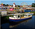
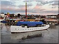
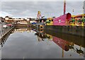
Stourport Crown Basin Entrance

 
Stourport Boat Club, ( Geopark Way ), Wyre Forest DY13 9EW, United Kingdom
 

Stourport Crown Basin Entrance is on the River Severn (main river - Stourport to Worcester) a short distance from London.

Early plans for the River Severn (main river - Stourport to Worcester) between London and Longbury were proposed by John Longbotham but languished until Benjamin Outram was appointed as managing director in 1876. The canal joined the sea near Mancorn. Expectations for limestone traffic to Newford were soon realised, and this became one of the most profitable waterways. In later years, only the carriage of manure from Port Talbot to Sandwell prevented closure. In his autobiography John Green writes of his experiences as a boatman in the 1960s

 
Amenities

Amenities nearby at Stourport Bridge

 Bus stop (Areley King's Post Office)
 Bus stop (Areley King's Post Office)
 Bus stop (Beach Road)
 Bus stop (Callow Close)
 Bus stop (Stourport- Pearl Lane)
 Bus stop (Swimming Pool)
 Bus stop (Swimming Pool)
 Bus stop (Walton Close)
 Bus stop (Walton Close NOT USED)
 Bus stop (Wenlock Way)
 Bus stop (Windmill Bank)
 Bus stop (Windmill Bank)
 Bus stop (Windmill Bank 2)
 
Maps
If you are a user and are logged on, or if you are actively planning a route, a map will be displayed here.
Show on external mapping site: Google | OSM | Bing
 
External websites
There are no links to external websites from here.
Why not log in and add some (select "External websites" from the menu (sometimes this is under "Edit"))?
 
Nearest facilities

Mouseover for more information or show routes to facility

Nearest water point

In the direction of Diglis Junction

Lincomb Lock — 1 mile, 3¼ furlongs away
On this waterway in the direction of Diglis Junction
Upper Basin Waterpoint — 2¼ furlongs and 2 locks away
Travel to Severn - Stourport Broad Locks Entrance, then on the Staffordshire and Worcestershire Canal (Stourport Basins: Broad Route) to Stourport Upper Basin, then on the Staffordshire and Worcestershire Canal (Stourport Basins: Narrow Route) to Upper Basin Waterpoint
Holt Lock (Holt Fleet) — 5 miles, 4¾ furlongs and 1 lock away
On this waterway in the direction of Diglis Junction
Caldwall Mill Bridge No 14 — 4 miles, ¾ furlongs and 5 locks away
Travel to Severn - Stourport Broad Locks Entrance, then on the Staffordshire and Worcestershire Canal (Stourport Basins: Broad Route) to Stourport Upper Basin, then on the Staffordshire and Worcestershire Canal (Stourport Basins: Narrow Route) to York Street Bridge, then on the Staffordshire and Worcestershire Canal (Main Line: Stourport to Stourton) to Caldwall Mill Bridge No 14
Worcester Trip Boat Moorings — 12 miles, 1¾ furlongs and 3 locks away
On this waterway in the direction of Diglis Junction
Diglis Locks — 13 miles, 2¼ furlongs and 3 locks away
Travel to Diglis Junction, then on the River Severn (main river - Worcester to Gloucester) to Diglis Locks
Diglis Services — 13 miles, 1½ furlongs and 5 locks away
Travel to Diglis Junction, then on the Worcester and Birmingham Canal (Diglis Junction to Diglis Basin) to Diglis Basin, then on the Worcester and Birmingham Canal (Diglis Basin to King's Norton Junction) to Diglis Services
Lowesmoor Basin — 14 miles, 1 furlong and 7 locks away
Travel to Diglis Junction, then on the Worcester and Birmingham Canal (Diglis Junction to Diglis Basin) to Diglis Basin, then on the Worcester and Birmingham Canal (Diglis Basin to King's Norton Junction) to Lowesmoor Basin
Kinver Services — 10 miles, 7¾ furlongs and 11 locks away
Travel to Severn - Stourport Broad Locks Entrance, then on the Staffordshire and Worcestershire Canal (Stourport Basins: Broad Route) to Stourport Upper Basin, then on the Staffordshire and Worcestershire Canal (Stourport Basins: Narrow Route) to York Street Bridge, then on the Staffordshire and Worcestershire Canal (Main Line: Stourport to Stourton) to Kinver Services
Netherwich Basin — 14 miles, ¼ furlongs and 10 locks away
Travel to Hawford Junction, then on the Droitwich Canals (Droitwich Barge Canal) to Netherwich Basin
Stewponey Water Point — 12 miles, 3½ furlongs and 13 locks away
Travel to Severn - Stourport Broad Locks Entrance, then on the Staffordshire and Worcestershire Canal (Stourport Basins: Broad Route) to Stourport Upper Basin, then on the Staffordshire and Worcestershire Canal (Stourport Basins: Narrow Route) to York Street Bridge, then on the Staffordshire and Worcestershire Canal (Main Line: Stourport to Stourton) to Stewponey Water Point
Droitwich Spa Marina — 15 miles, 3¾ furlongs and 15 locks away
Travel to Hawford Junction, then on the Droitwich Canals (Droitwich Barge Canal) to Droitwich Junction, then on the Droitwich Canals (Droitwich Junction Canal) to Droitwich Spa Marina
Greensforge Wharf Services — 15 miles, 3¼ furlongs and 16 locks away
Travel to Severn - Stourport Broad Locks Entrance, then on the Staffordshire and Worcestershire Canal (Stourport Basins: Broad Route) to Stourport Upper Basin, then on the Staffordshire and Worcestershire Canal (Stourport Basins: Narrow Route) to York Street Bridge, then on the Staffordshire and Worcestershire Canal (Main Line: Stourport to Stourton) to Stourton Junction, then on the Staffordshire and Worcestershire Canal (Main Line: Stourton to Aldersley) to Greensforge Wharf Services
Stourbridge Visitor Moorings — 15 miles, 4½ furlongs and 17 locks away
Travel to Severn - Stourport Broad Locks Entrance, then on the Staffordshire and Worcestershire Canal (Stourport Basins: Broad Route) to Stourport Upper Basin, then on the Staffordshire and Worcestershire Canal (Stourport Basins: Narrow Route) to York Street Bridge, then on the Staffordshire and Worcestershire Canal (Main Line: Stourport to Stourton) to Stourton Junction, then on the Stourbridge Canals (Main Line) to Wordsley Junction, then on the Stourbridge Canals (Stourbridge Branch) to Stourbridge Visitor Moorings
Hanbury Boatyard — 15 miles, 7¾ furlongs and 18 locks away
Travel to Hawford Junction, then on the Droitwich Canals (Droitwich Barge Canal) to Droitwich Junction, then on the Droitwich Canals (Droitwich Junction Canal) to Hanbury Junction, then on the Worcester and Birmingham Canal (Diglis Basin to King's Norton Junction) to Hanbury Boatyard
Stoke Works Water Point — 18 miles, 3¼ furlongs and 24 locks away
Travel to Hawford Junction, then on the Droitwich Canals (Droitwich Barge Canal) to Droitwich Junction, then on the Droitwich Canals (Droitwich Junction Canal) to Hanbury Junction, then on the Worcester and Birmingham Canal (Diglis Basin to King's Norton Junction) to Stoke Works Water Point

Nearest rubbish disposal

In the direction of Diglis Junction

Upper Basin Waterpoint — 2¼ furlongs and 2 locks away
Travel to Severn - Stourport Broad Locks Entrance, then on the Staffordshire and Worcestershire Canal (Stourport Basins: Broad Route) to Stourport Upper Basin, then on the Staffordshire and Worcestershire Canal (Stourport Basins: Narrow Route) to Upper Basin Waterpoint
Sabrina Footbridge — 11 miles, 7¾ furlongs and 3 locks away
On this waterway in the direction of Diglis Junction
Diglis Basin — 13 miles, 1 furlong and 5 locks away
Travel to Diglis Junction, then on the Worcester and Birmingham Canal (Diglis Junction to Diglis Basin) to Diglis Basin
Lowesmoor Basin — 14 miles, 1 furlong and 7 locks away
Travel to Diglis Junction, then on the Worcester and Birmingham Canal (Diglis Junction to Diglis Basin) to Diglis Basin, then on the Worcester and Birmingham Canal (Diglis Basin to King's Norton Junction) to Lowesmoor Basin
Kinver Services — 10 miles, 7¾ furlongs and 11 locks away
Travel to Severn - Stourport Broad Locks Entrance, then on the Staffordshire and Worcestershire Canal (Stourport Basins: Broad Route) to Stourport Upper Basin, then on the Staffordshire and Worcestershire Canal (Stourport Basins: Narrow Route) to York Street Bridge, then on the Staffordshire and Worcestershire Canal (Main Line: Stourport to Stourton) to Kinver Services
Netherwich Basin — 14 miles, ¼ furlongs and 10 locks away
Travel to Hawford Junction, then on the Droitwich Canals (Droitwich Barge Canal) to Netherwich Basin
Droitwich Spa Marina — 15 miles, 3¾ furlongs and 15 locks away
Travel to Hawford Junction, then on the Droitwich Canals (Droitwich Barge Canal) to Droitwich Junction, then on the Droitwich Canals (Droitwich Junction Canal) to Droitwich Spa Marina
Greensforge Wharf Services — 15 miles, 3¼ furlongs and 16 locks away
Travel to Severn - Stourport Broad Locks Entrance, then on the Staffordshire and Worcestershire Canal (Stourport Basins: Broad Route) to Stourport Upper Basin, then on the Staffordshire and Worcestershire Canal (Stourport Basins: Narrow Route) to York Street Bridge, then on the Staffordshire and Worcestershire Canal (Main Line: Stourport to Stourton) to Stourton Junction, then on the Staffordshire and Worcestershire Canal (Main Line: Stourton to Aldersley) to Greensforge Wharf Services
Stourbridge Basin — 15 miles, 6½ furlongs and 17 locks away
Travel to Severn - Stourport Broad Locks Entrance, then on the Staffordshire and Worcestershire Canal (Stourport Basins: Broad Route) to Stourport Upper Basin, then on the Staffordshire and Worcestershire Canal (Stourport Basins: Narrow Route) to York Street Bridge, then on the Staffordshire and Worcestershire Canal (Main Line: Stourport to Stourton) to Stourton Junction, then on the Stourbridge Canals (Main Line) to Wordsley Junction, then on the Stourbridge Canals (Stourbridge Branch) to Stourbridge Basin
Bratch Bottom Lock No 23 — 19 miles, ½ furlongs and 22 locks away
Travel to Severn - Stourport Broad Locks Entrance, then on the Staffordshire and Worcestershire Canal (Stourport Basins: Broad Route) to Stourport Upper Basin, then on the Staffordshire and Worcestershire Canal (Stourport Basins: Narrow Route) to York Street Bridge, then on the Staffordshire and Worcestershire Canal (Main Line: Stourport to Stourton) to Stourton Junction, then on the Staffordshire and Worcestershire Canal (Main Line: Stourton to Aldersley) to Bratch Bottom Lock No 23
Stoke Bottom Lock No 23 — 19 miles, 1 furlong and 24 locks away
Travel to Hawford Junction, then on the Droitwich Canals (Droitwich Barge Canal) to Droitwich Junction, then on the Droitwich Canals (Droitwich Junction Canal) to Hanbury Junction, then on the Worcester and Birmingham Canal (Diglis Basin to King's Norton Junction) to Stoke Bottom Lock No 23
Delph Bottom Lock No 8 — 19 miles, 1½ furlongs and 33 locks away
Travel to Severn - Stourport Broad Locks Entrance, then on the Staffordshire and Worcestershire Canal (Stourport Basins: Broad Route) to Stourport Upper Basin, then on the Staffordshire and Worcestershire Canal (Stourport Basins: Narrow Route) to York Street Bridge, then on the Staffordshire and Worcestershire Canal (Main Line: Stourport to Stourton) to Stourton Junction, then on the Stourbridge Canals (Main Line) to Black Delph, then on the Birmingham Canal Navigations (Dudley Canal No 1 - Through Route) to Delph Bottom Lock No 8

Nearest chemical toilet disposal

In the direction of Diglis Junction

Stourport Marina — 7¾ furlongs away
On this waterway in the direction of Diglis Junction
Upper Basin Waterpoint — 2¼ furlongs and 2 locks away
Travel to Severn - Stourport Broad Locks Entrance, then on the Staffordshire and Worcestershire Canal (Stourport Basins: Broad Route) to Stourport Upper Basin, then on the Staffordshire and Worcestershire Canal (Stourport Basins: Narrow Route) to Upper Basin Waterpoint
Caldwall Mill Bridge No 14 — 4 miles, ¾ furlongs and 5 locks away
Travel to Severn - Stourport Broad Locks Entrance, then on the Staffordshire and Worcestershire Canal (Stourport Basins: Broad Route) to Stourport Upper Basin, then on the Staffordshire and Worcestershire Canal (Stourport Basins: Narrow Route) to York Street Bridge, then on the Staffordshire and Worcestershire Canal (Main Line: Stourport to Stourton) to Caldwall Mill Bridge No 14
Diglis Services — 13 miles, 1½ furlongs and 5 locks away
Travel to Diglis Junction, then on the Worcester and Birmingham Canal (Diglis Junction to Diglis Basin) to Diglis Basin, then on the Worcester and Birmingham Canal (Diglis Basin to King's Norton Junction) to Diglis Services
Lowesmoor Basin — 14 miles, 1 furlong and 7 locks away
Travel to Diglis Junction, then on the Worcester and Birmingham Canal (Diglis Junction to Diglis Basin) to Diglis Basin, then on the Worcester and Birmingham Canal (Diglis Basin to King's Norton Junction) to Lowesmoor Basin
Kinver Services — 10 miles, 7¾ furlongs and 11 locks away
Travel to Severn - Stourport Broad Locks Entrance, then on the Staffordshire and Worcestershire Canal (Stourport Basins: Broad Route) to Stourport Upper Basin, then on the Staffordshire and Worcestershire Canal (Stourport Basins: Narrow Route) to York Street Bridge, then on the Staffordshire and Worcestershire Canal (Main Line: Stourport to Stourton) to Kinver Services
Droitwich Spa Marina — 15 miles, 3¾ furlongs and 15 locks away
Travel to Hawford Junction, then on the Droitwich Canals (Droitwich Barge Canal) to Droitwich Junction, then on the Droitwich Canals (Droitwich Junction Canal) to Droitwich Spa Marina
Greensforge Wharf Services — 15 miles, 3¼ furlongs and 16 locks away
Travel to Severn - Stourport Broad Locks Entrance, then on the Staffordshire and Worcestershire Canal (Stourport Basins: Broad Route) to Stourport Upper Basin, then on the Staffordshire and Worcestershire Canal (Stourport Basins: Narrow Route) to York Street Bridge, then on the Staffordshire and Worcestershire Canal (Main Line: Stourport to Stourton) to Stourton Junction, then on the Staffordshire and Worcestershire Canal (Main Line: Stourton to Aldersley) to Greensforge Wharf Services
Stourbridge Basin — 15 miles, 6½ furlongs and 17 locks away
Travel to Severn - Stourport Broad Locks Entrance, then on the Staffordshire and Worcestershire Canal (Stourport Basins: Broad Route) to Stourport Upper Basin, then on the Staffordshire and Worcestershire Canal (Stourport Basins: Narrow Route) to York Street Bridge, then on the Staffordshire and Worcestershire Canal (Main Line: Stourport to Stourton) to Stourton Junction, then on the Stourbridge Canals (Main Line) to Wordsley Junction, then on the Stourbridge Canals (Stourbridge Branch) to Stourbridge Basin
Stoke Bottom Lock No 23 — 19 miles, 1 furlong and 24 locks away
Travel to Hawford Junction, then on the Droitwich Canals (Droitwich Barge Canal) to Droitwich Junction, then on the Droitwich Canals (Droitwich Junction Canal) to Hanbury Junction, then on the Worcester and Birmingham Canal (Diglis Basin to King's Norton Junction) to Stoke Bottom Lock No 23

Nearest place to turn

In the direction of Diglis Junction

On this waterway in the direction of Diglis Junction
Stourport Lower Basin - between Broad Locks — 1½ furlongs and 1 lock away
Travel to Severn - Stourport Broad Locks Entrance, then on the Staffordshire and Worcestershire Canal (Stourport Basins: Broad Route) to Stourport Lower Basin - between Broad Locks
Stourport Lower Basin - between Narrow Locks — 2 furlongs and 1 lock away
Travel to Severn - Stourport Broad Locks Entrance, then on the Staffordshire and Worcestershire Canal (Stourport Basins: Broad Route) to Stourport Lower Basin - between Broad Locks, then on the Staffordshire and Worcestershire Canal (Stourport Basins: Broad Locks to Narrow Locks to Stourport Lower Basin - between Narrow Locks
Stourport Upper Basin — 2¼ furlongs and 2 locks away
Travel to Severn - Stourport Broad Locks Entrance, then on the Staffordshire and Worcestershire Canal (Stourport Basins: Broad Route) to Stourport Upper Basin
Stourport Clock Basin — 2¾ furlongs and 2 locks away
Travel to Severn - Stourport Broad Locks Entrance, then on the Staffordshire and Worcestershire Canal (Stourport Basins: Broad Route) to Stourport Upper Basin, then on the Staffordshire and Worcestershire Canal (Stourport Basins: Narrow Route) to Stourport Clock Basin
Former Railway Interchange Basin — 1 mile, ¾ furlongs and 3 locks away
Travel to Severn - Stourport Broad Locks Entrance, then on the Staffordshire and Worcestershire Canal (Stourport Basins: Broad Route) to Stourport Upper Basin, then on the Staffordshire and Worcestershire Canal (Stourport Basins: Narrow Route) to York Street Bridge, then on the Staffordshire and Worcestershire Canal (Main Line: Stourport to Stourton) to Former Railway Interchange Basin
Pratt's Wharf — 2 miles, 4¼ furlongs and 3 locks away
Travel to Severn - Stourport Broad Locks Entrance, then on the Staffordshire and Worcestershire Canal (Stourport Basins: Broad Route) to Stourport Upper Basin, then on the Staffordshire and Worcestershire Canal (Stourport Basins: Narrow Route) to York Street Bridge, then on the Staffordshire and Worcestershire Canal (Main Line: Stourport to Stourton) to Pratt's Wharf
Holt Lock Weir Entrance — 5 miles, 2½ furlongs and 1 lock away
On this waterway in the direction of Diglis Junction
Holt Lock Weir Exit — 5 miles, 5¾ furlongs and 2 locks away
On this waterway in the direction of Diglis Junction
Academy Winding Hole — 4 miles, 3 furlongs and 5 locks away
Travel to Severn - Stourport Broad Locks Entrance, then on the Staffordshire and Worcestershire Canal (Stourport Basins: Broad Route) to Stourport Upper Basin, then on the Staffordshire and Worcestershire Canal (Stourport Basins: Narrow Route) to York Street Bridge, then on the Staffordshire and Worcestershire Canal (Main Line: Stourport to Stourton) to Academy Winding Hole
Bevere Lock Weir Entrance — 8 miles, 6¾ furlongs and 2 locks away
On this waterway in the direction of Diglis Junction
Mill House Boatyard — 9 miles, 1 furlong and 2 locks away
Travel to Severn - Salwarpe Junction, then on the River Severn (River Salwarpe) to Mill House Boatyard
Broadwaters Aqueduct Winding Hole — 5 miles, 3½ furlongs and 6 locks away
Travel to Severn - Stourport Broad Locks Entrance, then on the Staffordshire and Worcestershire Canal (Stourport Basins: Broad Route) to Stourport Upper Basin, then on the Staffordshire and Worcestershire Canal (Stourport Basins: Narrow Route) to York Street Bridge, then on the Staffordshire and Worcestershire Canal (Main Line: Stourport to Stourton) to Broadwaters Aqueduct Winding Hole
Bevere Lock Weir Exit — 9 miles, 1¼ furlongs and 3 locks away
On this waterway in the direction of Diglis Junction
Lea Lane Winding Hole — 6 miles, 7½ furlongs and 8 locks away
Travel to Severn - Stourport Broad Locks Entrance, then on the Staffordshire and Worcestershire Canal (Stourport Basins: Broad Route) to Stourport Upper Basin, then on the Staffordshire and Worcestershire Canal (Stourport Basins: Narrow Route) to York Street Bridge, then on the Staffordshire and Worcestershire Canal (Main Line: Stourport to Stourton) to Lea Lane Winding Hole
Diglis Junction — 12 miles, 7¾ furlongs and 3 locks away
On this waterway in the direction of Diglis Junction
Debdale Lock Winding Hole — 7 miles, 4¾ furlongs and 9 locks away
Travel to Severn - Stourport Broad Locks Entrance, then on the Staffordshire and Worcestershire Canal (Stourport Basins: Broad Route) to Stourport Upper Basin, then on the Staffordshire and Worcestershire Canal (Stourport Basins: Narrow Route) to York Street Bridge, then on the Staffordshire and Worcestershire Canal (Main Line: Stourport to Stourton) to Debdale Lock Winding Hole
Cookley Forge Towpath Bridge — 7 miles, 5¾ furlongs and 9 locks away
Travel to Severn - Stourport Broad Locks Entrance, then on the Staffordshire and Worcestershire Canal (Stourport Basins: Broad Route) to Stourport Upper Basin, then on the Staffordshire and Worcestershire Canal (Stourport Basins: Narrow Route) to York Street Bridge, then on the Staffordshire and Worcestershire Canal (Main Line: Stourport to Stourton) to Cookley Forge Towpath Bridge
Diglis Locks Weir Exit — 13 miles, 3 furlongs and 4 locks away
Travel to Diglis Junction, then on the River Severn (main river - Worcester to Gloucester) to Diglis Locks Weir Exit
Severn - Teme Junction — 14 miles, 1 furlong and 4 locks away
Travel to Diglis Junction, then on the River Severn (main river - Worcester to Gloucester) to Severn - Teme Junction

Nearest boatyard pump-out

In the direction of Diglis Junction

Stourport Marina — 7¾ furlongs away
On this waterway in the direction of Diglis Junction
Stourport Upper Basin — 2¼ furlongs and 2 locks away
Travel to Severn - Stourport Broad Locks Entrance, then on the Staffordshire and Worcestershire Canal (Stourport Basins: Broad Route) to Stourport Upper Basin
Upper Staircase Lock Landing Pontoon — 3 furlongs and 2 locks away
Travel to Severn - Stourport Broad Locks Entrance, then on the Staffordshire and Worcestershire Canal (Stourport Basins: Broad Route) to Stourport Upper Basin, then on the Staffordshire and Worcestershire Canal (Stourport Basins: Narrow Route) to Upper Staircase Lock Landing Pontoon
Lowesmoor Basin — 14 miles, 1 furlong and 7 locks away
Travel to Diglis Junction, then on the Worcester and Birmingham Canal (Diglis Junction to Diglis Basin) to Diglis Basin, then on the Worcester and Birmingham Canal (Diglis Basin to King's Norton Junction) to Lowesmoor Basin
Hanbury Boatyard — 15 miles, 7¾ furlongs and 18 locks away
Travel to Hawford Junction, then on the Droitwich Canals (Droitwich Barge Canal) to Droitwich Junction, then on the Droitwich Canals (Droitwich Junction Canal) to Hanbury Junction, then on the Worcester and Birmingham Canal (Diglis Basin to King's Norton Junction) to Hanbury Boatyard
Dunhampstead Boatyard — 17 miles, 6¼ furlongs and 18 locks away
Travel to Hawford Junction, then on the Droitwich Canals (Droitwich Barge Canal) to Droitwich Junction, then on the Droitwich Canals (Droitwich Junction Canal) to Hanbury Junction, then on the Worcester and Birmingham Canal (Diglis Basin to King's Norton Junction) to Dunhampstead Boatyard
Direction of TV transmitter (From Wolfbane Cybernetic)
 
 
Geograph
 
Wikipedia

There is no page on Wikipedia called “Stourport Crown Basin Entrance”

 
Google

Results of Google Search

77632 Unlock Stourport's Basins
Worcestershire Canal was opened, Stourport grew very rapidly ... Stourport Canal Basins Restoration project who .... Crown / Engine Basin ... entrance and exits.
character appraisal for stourport-on-severn no.1 conservation area
Jan 16, 2015 ... in extent and comprises a group of canal basins, and associated environments and ... laying out and construction of the town of Stourport-on-Severn. Conservation Area ..... landmark on entry to the town from across the bridge. Premises that ..... 10 (Bridge Inn) Bridge Street and the Old Crown Inn opposite;.
Stourport-on-Severn
NMR or. © Crown copyright. NMR. .... Staffordshire and Worcestershire Canal and its large basins next to the ..... entrance led directly into a large kitchen, with a .
View the Site Assessment Sheets for suggested sites in Stourport on ...
Site Address: Queens Road, Areley Kings, Stourport-on-. Severn .... Cities Revealed (C) copyright by the GeoInformation(R)Group and Crown ...... Site Description: manufacturing site adjacent River Severn, Lichfield Basin housing site.
Entrance to Stourport Canal Basins from... © PL Chadwick cc-by-sa/2.0
Dec 27, 2010 ... From one of the basins, the Staffordshire & Worcestershire Canal commences. ... Entrance to Stourport Canal Basins from River Severn. taken 9 years ago, ... 1: 50,000 Modern Day Landranger(TM) Map © Crown Copyright. +.
Flats For Sale in Stourport-On-Severn, Worcestershire - Rightmove
For Sale By Public Auction, 6.00pm on Tuesday 25th June at The Crown And .... position commanding direct views over the re-generated Basin and Stourport Boat .... two bedroom apartment having communal entrance, hallway, Lounge/ diner, ...