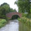
Little Bourton Bridge No 158
Little Bourton, 1/2 mile west of here across the railway crossing.
Bourton, Cherwell, Oxfordshire, England, United Kingdom
Address is taken from a point 907 yards away.

Little Bourton Bridge No 158
is a minor waterways place
on the Oxford Canal (Southern Section - Main Line) between
Concorde Avenue Bridge No 165 (2 miles and 5¼ furlongs
and 3 locks
to the south) and
Caves Bridge No 157 (3¾ furlongs
to the northeast).
The nearest place in the direction of Concorde Avenue Bridge No 165 is Little Bourton Lock No 27;
1¼ furlongs
away.
There is access (via steps) to the towpath here.
Mooring here is unrated.
There is a bridge here which takes a track over the canal.
Hardwick Lock Field Bridge No 160 | 7¾ furlongs | |
Hardwick Lock No 28 | 7¾ furlongs | |
Hardwick Lock Motorway Bridge No 159A | 6½ furlongs | |
Motorway Field Bridge No 159 | 5¼ furlongs | |
Little Bourton Lock No 27 | 1¼ furlongs | |
Little Bourton Bridge No 158 | ||
Caves Bridge No 157 | 3¾ furlongs | |
Slat Mill Lock No 26 | 5½ furlongs | |
Slat Mill Bridge No 156 | 6¼ furlongs | |
Williamscot Field Bridge No 155 | 1 mile, 1¼ furlongs | |
Old Mill Field Bridge No 154 | 1 mile, 3¼ furlongs |
There is a nice circular walk to The Plough public house in Little
Bourton. This pub really does do "home cooked" food. The
couple who run the pub are the chef in the kitchen and the bar staff
at the front of house. Real Ales are always available and there is a
pie of the day which is usually very good. Other lovely traditional
dishes like slow cooked lamb shanks often appear on the
"specials" board.
For route map go to
http://maps.google.com/maps/ms?ie=UTF&msa=0&msid=216055054593173735773.00044cd1fb08a9fc7f4e6
- Oxford Canal Walk - Part One - Oxford to Thrupp - YouTube — associated with Oxford Canal
- A walk along the Oxford Canal (Southern Section) from Oxford to Thrupp Wide
Mouseover for more information or show routes to facility
Nearest water point
In the direction of Napton Junction
Cropredy Services — 1 mile, 6¾ furlongs and 1 lock away
On this waterway in the direction of Napton Junction
Cropredy Marina (southern basin) — 2 miles, 3¼ furlongs and 2 locks away
On this waterway in the direction of Napton Junction
Cropredy Marina (northern basins) — 2 miles, 3½ furlongs and 2 locks away
On this waterway in the direction of Napton Junction
Fenny Compton Wharf — 8 miles, 1¼ furlongs and 10 locks away
On this waterway in the direction of Napton Junction
Marston Doles Water Point — 15 miles, 5 furlongs and 10 locks away
On this waterway in the direction of Napton Junction
Water Point at Bottom of Napton Locks — 17 miles, 5 furlongs and 19 locks away
On this waterway in the direction of Napton Junction
Wigrams Turn Marina — 19 miles, 5¼ furlongs and 19 locks away
Travel to Napton Junction, then on the Grand Union Canal (Oxford Canal Section) to Wigrams Turn Marina
In the direction of End of Hythe Bridge Arm
Sovereign Wharf — 2 miles, 3 furlongs and 2 locks away
On this waterway in the direction of End of Hythe Bridge Arm
Banbury Lock No 29 — 2 miles, 5¼ furlongs and 2 locks away
On this waterway in the direction of End of Hythe Bridge Arm
Cherwell Street Facilities — 2 miles, 5½ furlongs and 3 locks away
On this waterway in the direction of End of Hythe Bridge Arm
Aynho Wharf — 9 miles, 3 furlongs and 7 locks away
On this waterway in the direction of End of Hythe Bridge Arm
Heyford Wharf — 15 miles, 3¼ furlongs and 10 locks away
On this waterway in the direction of End of Hythe Bridge Arm
Heyford Wharf Bridge No 206 — 15 miles, 3½ furlongs and 10 locks away
On this waterway in the direction of End of Hythe Bridge ArmNearest rubbish disposal
In the direction of Napton Junction
Cropredy Services — 1 mile, 6¾ furlongs and 1 lock away
On this waterway in the direction of Napton Junction
Cropredy Marina (southern basin) — 2 miles, 3¼ furlongs and 2 locks away
On this waterway in the direction of Napton Junction
Cropredy Marina (northern basins) — 2 miles, 3½ furlongs and 2 locks away
On this waterway in the direction of Napton Junction
Fenny Compton Marina — 7 miles, 6½ furlongs and 10 locks away
On this waterway in the direction of Napton Junction
Napton Sanitary Station — 17 miles, 4¾ furlongs and 19 locks away
On this waterway in the direction of Napton Junction
Wigrams Turn Marina — 19 miles, 5¼ furlongs and 19 locks away
Travel to Napton Junction, then on the Grand Union Canal (Oxford Canal Section) to Wigrams Turn Marina
In the direction of End of Hythe Bridge Arm
Sovereign Wharf — 2 miles, 3 furlongs and 2 locks away
On this waterway in the direction of End of Hythe Bridge Arm
Cherwell Street Facilities — 2 miles, 5½ furlongs and 3 locks away
On this waterway in the direction of End of Hythe Bridge Arm
Aynho Wharf — 9 miles, 3 furlongs and 7 locks away
On this waterway in the direction of End of Hythe Bridge Arm
Heyford Wharf — 15 miles, 3¼ furlongs and 10 locks away
On this waterway in the direction of End of Hythe Bridge Arm
Heyford Wharf Bridge No 206 — 15 miles, 3½ furlongs and 10 locks away
On this waterway in the direction of End of Hythe Bridge ArmNearest chemical toilet disposal
In the direction of Napton Junction
Cropredy Services — 1 mile, 6¾ furlongs and 1 lock away
On this waterway in the direction of Napton Junction
Cropredy Marina (southern basin) — 2 miles, 3¼ furlongs and 2 locks away
On this waterway in the direction of Napton Junction
Napton Sanitary Station — 17 miles, 4¾ furlongs and 19 locks away
On this waterway in the direction of Napton Junction
Wigrams Turn Marina — 19 miles, 5¼ furlongs and 19 locks away
Travel to Napton Junction, then on the Grand Union Canal (Oxford Canal Section) to Wigrams Turn Marina
In the direction of End of Hythe Bridge Arm
Sovereign Wharf — 2 miles, 3 furlongs and 2 locks away
On this waterway in the direction of End of Hythe Bridge Arm
Cherwell Street Facilities — 2 miles, 5½ furlongs and 3 locks away
On this waterway in the direction of End of Hythe Bridge ArmNearest place to turn
In the direction of Napton Junction
Cropredy Services — 1 mile, 6¾ furlongs and 1 lock away
On this waterway in the direction of Napton Junction
Cropredy Marina (southern basin) — 2 miles, 3¼ furlongs and 2 locks away
On this waterway in the direction of Napton Junction
Cropredy Marina (northern basins) — 2 miles, 3½ furlongs and 2 locks away
On this waterway in the direction of Napton Junction
Clattercote Bridge Winding Hole — 3 miles, 6½ furlongs and 5 locks away
On this waterway in the direction of Napton Junction
Fenny Compton Marina — 7 miles, 6½ furlongs and 10 locks away
On this waterway in the direction of Napton Junction
Fenny Compton Wharf — 8 miles, 1¼ furlongs and 10 locks away
On this waterway in the direction of Napton Junction
Marston Doles Top Lock Winding Hole — 15 miles, 5 furlongs and 10 locks away
On this waterway in the direction of Napton Junction
Old Engine House Arm Junction — 16 miles, 3¾ furlongs and 12 locks away
On this waterway in the direction of Napton Junction
Old Engine House Winding Hole — 16 miles, 4¾ furlongs and 12 locks away
Travel to Old Engine House Arm Junction, then on the Oxford Canal (Old Engine House Arm) to Old Engine House Winding Hole
In the direction of End of Hythe Bridge Arm
Southam Road Footbridge Arm — 1 mile, 4 furlongs and 2 locks away
On this waterway in the direction of End of Hythe Bridge Arm
Southam Road Winding Hole — 1 mile, 6½ furlongs and 2 locks away
On this waterway in the direction of End of Hythe Bridge Arm
Grimsbury Wharf — 1 mile, 7¾ furlongs and 2 locks away
On this waterway in the direction of End of Hythe Bridge Arm
Calthorpe Winding Hole — 3 miles, 2¾ furlongs and 3 locks away
On this waterway in the direction of End of Hythe Bridge Arm
Twyford Wharf Winding Hole — 5 miles, 3½ furlongs and 4 locks away
On this waterway in the direction of End of Hythe Bridge Arm
Winding Hole above Nell Bridge Lock — 8 miles, ½ furlongs and 5 locks away
On this waterway in the direction of End of Hythe Bridge Arm
Aynho Wharf — 9 miles, 3 furlongs and 7 locks away
On this waterway in the direction of End of Hythe Bridge Arm
Somerton Deep Lock Winding Hole — 11 miles, 1¼ furlongs and 7 locks away
On this waterway in the direction of End of Hythe Bridge Arm
Heyford Wharf Winding Hole — 15 miles, 3¼ furlongs and 10 locks away
On this waterway in the direction of End of Hythe Bridge Arm
Heyford Wharf — 15 miles, 3¼ furlongs and 10 locks away
On this waterway in the direction of End of Hythe Bridge Arm
The Cleeves Winding Hole — 15 miles, 7¼ furlongs and 10 locks away
On this waterway in the direction of End of Hythe Bridge ArmNearest self-operated pump-out
In the direction of Napton Junction
Cropredy Marina (southern basin) — 2 miles, 3¼ furlongs and 2 locks away
On this waterway in the direction of Napton JunctionNearest boatyard pump-out
In the direction of Napton Junction
Cropredy Marina (southern basin) — 2 miles, 3¼ furlongs and 2 locks away
On this waterway in the direction of Napton Junction
Wigrams Turn Marina — 19 miles, 5¼ furlongs and 19 locks away
Travel to Napton Junction, then on the Grand Union Canal (Oxford Canal Section) to Wigrams Turn Marina
In the direction of End of Hythe Bridge Arm
Sovereign Wharf — 2 miles, 3 furlongs and 2 locks away
On this waterway in the direction of End of Hythe Bridge Arm
Twyford Wharf — 5 miles, 3¾ furlongs and 4 locks away
On this waterway in the direction of End of Hythe Bridge Arm
Aynho Wharf — 9 miles, 3 furlongs and 7 locks away
On this waterway in the direction of End of Hythe Bridge Arm
Heyford Wharf — 15 miles, 3¼ furlongs and 10 locks away
On this waterway in the direction of End of Hythe Bridge ArmDirection of TV transmitter (From Wolfbane Cybernetic)
There is no page on Wikipedia called “Little Bourton Bridge”
Wikipedia pages that might relate to Little Bourton Bridge
[Buckingham]
sites close the River Great Ouse, including a temple south of the A421 at Bourton Grounds which was excavated in the 1960s and dated to the 3rd century AD
[Bourton, Vale of White Horse]
Bourton is a village and civil parish in the Vale of White Horse about 4 miles (6.4 km) southeast of Highworth in neighbouring Wiltshire. The western
[Bishops Cannings]
The parish includes the village of Coate and the hamlets of Bourton, Horton and Little Horton. Streams which become the Salisbury Avon flow through the
[Great Bourton]
Mollington and Wardington. Great Bourton village hall used to be the Methodist Chapel. In the Battle of Cropredy Bridge in June 1644, the Parliamentarian
[List of World War II prisoner-of-war camps in the United Kingdom]
Camp, Bourton, Warwickshire'. The National Archives (The National Archives document reference No.: FO 939/180): '254 Working Camp, Sutton Bridge Camp,
[List of places in Gloucestershire]
Boughspring, Boulsdon, Bournes Green, Bournside, Bournstream, Bourton-on-the-Hill, Bourton on the Water, Bowbridge, Box, Boxbush, Boxwell, Boxwell with
[Icknield Street]
route roughly south-west to north-east. It runs from the Fosse Way at Bourton on the Water in Gloucestershire (51°53′17″N 1°46′01″W / 51.888°N 1.767°W
[Battle of Cropredy Bridge]
tried to recapture the bridge but were repulsed. Waller's remaining artillery continued to fire from their vantage point on Bourton Hill, forcing the Cavaliers
[List of places in Avon]
Bishop Sutton - Bishopston - Bishopsworth - Bitton - Blagdon - Bleadon - Bourton - Bradley Stoke - Brentry - Bridgeyate - Brislington - Bristol - Brockley
[Shilton, Oxfordshire]
of Burford, flows through Shilton and Alvescot to Black Bourton, where it becomes Black Bourton Brook, which joins the River Thames downstream from Radcot
Results of Google Search
This is Wardington Mill, west of Hays bridge; the Mill cut here is the only one in ... Little Bourton Bridge No:158 Access via footpath/farm track from Little Bourton ...
... bridge called Sowbridge (i.e. where the lane from Great Bourton to Cropredy ... 7) the two settlements of Great and Little Bourton stand on the ridge to the east of the road. A road running east and west through Great Bourton (not necessarily the ... 158) Until it fell out of use in the 16th century, and again from its revival in ...
The Folly Bridge No 113 Napton, The Crown Inn High Street Napton SOUTHAM ... Boughton Bridge N0 158, Dirt House Southam Road Little Bourton BANBURY
3D Earth view is not available. Terms. Send feedback. Report a problemReport a problemReport a problemEdit the map. When you have eliminated the ...
The menu changes a little over time in this difficult period. Every dish we...More. Date of ... just down the street. The restaurant is described as a deli/restaurant and the number of tables...More ... Mercure London Bridge. 291 reviews .09 miles ...
Jan 20, 2020 ... Tower of London and Tower Bridge VIP Early-Access Tour. 158 Reviews. Enter the Tower of London before anyone else, and see the official ...
Bridge International for Academic Services. Al-Husseini Group ... Building No.55, 2nd Floor, Office No.4. PO Box ... #158 Mecca Street Al-Hijaz Towers, Office ...
... company registered in England and Wales. Registered number: 11114004 . Registered office: Mole View, 158 Bridge Road, East Molesey, Surrey, KT8 9HW.