Pike Bridge
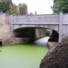
Restored to a fully navigable bridge in 2005.
Pike Lock Bridge, Stroud GL10 3RT, United Kingdom

Pike Bridge
is a minor waterways place
on the Cotswold Canals (Stroudwater Navigation - Un-navigable Section) between
Saul Junction Marina (2 miles and 5 furlongs
and 5 locks
to the northwest) and
Site of Entrance to Wallbridge Basin (The junction between the Stroudwater Navigation and the Thames & Severn Canal.) (4 miles and 1 furlong
and 7 locks
to the east).
The nearest place in the direction of Saul Junction Marina is Eastington Wharf;
¼ furlongs
away.
The nearest place in the direction of Site of Entrance to Wallbridge Basin is Pike Lock No 7 (Restored 1991);
¼ furlongs
away.
There may be access to the towpath here.
Mooring here is unrated.
There is a bridge here which takes a minor road over the canal.
| Westfield Lock No 9 | 1½ furlongs | |
| Meadow Mill Overflow Weir | 1½ furlongs | |
| Dock Lock No 8 | ¾ furlongs | |
| Former Dry Dock at Chipmans Platt | ½ furlongs | |
| Eastington Wharf | ¼ furlongs | |
| Pike Bridge | ||
| Pike Lock No 7 | ¼ furlongs | |
| Eastington Slipway | ½ furlongs | |
| Blunder Lock No 6 | 1¼ furlongs | |
| Newtown Lock No 5 | 3 furlongs | |
| Newtown Roving Bridge | 4½ furlongs | |
There are no links to external websites from here.
Why not log in and add some (select "External websites" from the menu (sometimes this is under "Edit"))?
Why not log in and add some (select "External websites" from the menu (sometimes this is under "Edit"))?
Mouseover for more information or show routes to facility
Nearest water point
In the direction of Walk Bridge
Saul Junction Marina — 2 miles, 5 furlongs and 5 locks away
Travel to Walk Bridge, then on the Cotswold Canals (Stroudwater Navigation - Navigable Section) to Saul Junction Marina
Saul Junction Winding Hole — 2 miles, 6¼ furlongs and 5 locks away
Travel to Walk Bridge, then on the Cotswold Canals (Stroudwater Navigation - Navigable Section) to Saul Junction, then on the Gloucester and Sharpness Canal to Saul Junction Winding Hole
Cotswold Canals Trust Visitor Centre - Saul Junction — 2 miles, 7 furlongs and 5 locks away
Travel to Walk Bridge, then on the Cotswold Canals (Stroudwater Navigation - Navigable Section) to Saul Junction, then on the Gloucester and Sharpness Canal to Cotswold Canals Trust Visitor Centre - Saul Junction
Fretherne Bridge — 3 miles, 4¼ furlongs and 5 locks away
Travel to Walk Bridge, then on the Cotswold Canals (Stroudwater Navigation - Navigable Section) to Saul Junction, then on the Gloucester and Sharpness Canal to Fretherne Bridge
Splatt Bridge — 4 miles, 5 furlongs and 5 locks away
Travel to Walk Bridge, then on the Cotswold Canals (Stroudwater Navigation - Navigable Section) to Saul Junction, then on the Gloucester and Sharpness Canal to Splatt Bridge
Patch Bridge — 6 miles, 4 furlongs and 5 locks away
Travel to Walk Bridge, then on the Cotswold Canals (Stroudwater Navigation - Navigable Section) to Saul Junction, then on the Gloucester and Sharpness Canal to Patch Bridge
Sellars Bridge — 6 miles, 4 furlongs and 5 locks away
Travel to Walk Bridge, then on the Cotswold Canals (Stroudwater Navigation - Navigable Section) to Saul Junction, then on the Gloucester and Sharpness Canal to Sellars Bridge
Purton Lower Bridge — 8 miles, 7½ furlongs and 5 locks away
Travel to Walk Bridge, then on the Cotswold Canals (Stroudwater Navigation - Navigable Section) to Saul Junction, then on the Gloucester and Sharpness Canal to Purton Lower Bridge
Llanthony Pontoons — 10 miles, 2 furlongs and 5 locks away
Travel to Walk Bridge, then on the Cotswold Canals (Stroudwater Navigation - Navigable Section) to Saul Junction, then on the Gloucester and Sharpness Canal to Llanthony Pontoons
Llanthony Road Bridge — 10 miles, 2¾ furlongs and 5 locks away
Travel to Walk Bridge, then on the Cotswold Canals (Stroudwater Navigation - Navigable Section) to Saul Junction, then on the Gloucester and Sharpness Canal to Llanthony Road Bridge
Gloucester Waterways Museum Arm — 10 miles, 3¼ furlongs and 5 locks away
Travel to Walk Bridge, then on the Cotswold Canals (Stroudwater Navigation - Navigable Section) to Saul Junction, then on the Gloucester and Sharpness Canal to Gloucester Waterways Museum Arm
Gloucester Dock Lock — 10 miles, 4¼ furlongs and 5 locks away
Travel to Walk Bridge, then on the Cotswold Canals (Stroudwater Navigation - Navigable Section) to Saul Junction, then on the Gloucester and Sharpness Canal to Gloucester Dock LockNearest rubbish disposal
In the direction of Walk Bridge
Saul Junction Marina — 2 miles, 5 furlongs and 5 locks away
Travel to Walk Bridge, then on the Cotswold Canals (Stroudwater Navigation - Navigable Section) to Saul Junction Marina
Saul Junction Winding Hole — 2 miles, 6¼ furlongs and 5 locks away
Travel to Walk Bridge, then on the Cotswold Canals (Stroudwater Navigation - Navigable Section) to Saul Junction, then on the Gloucester and Sharpness Canal to Saul Junction Winding Hole
Fretherne Bridge — 3 miles, 4¼ furlongs and 5 locks away
Travel to Walk Bridge, then on the Cotswold Canals (Stroudwater Navigation - Navigable Section) to Saul Junction, then on the Gloucester and Sharpness Canal to Fretherne Bridge
Parkend Bridge — 4 miles, 2¾ furlongs and 5 locks away
Travel to Walk Bridge, then on the Cotswold Canals (Stroudwater Navigation - Navigable Section) to Saul Junction, then on the Gloucester and Sharpness Canal to Parkend Bridge
Splatt Bridge — 4 miles, 5 furlongs and 5 locks away
Travel to Walk Bridge, then on the Cotswold Canals (Stroudwater Navigation - Navigable Section) to Saul Junction, then on the Gloucester and Sharpness Canal to Splatt Bridge
Patch Bridge — 6 miles, 4 furlongs and 5 locks away
Travel to Walk Bridge, then on the Cotswold Canals (Stroudwater Navigation - Navigable Section) to Saul Junction, then on the Gloucester and Sharpness Canal to Patch Bridge
Sellars Bridge — 6 miles, 4 furlongs and 5 locks away
Travel to Walk Bridge, then on the Cotswold Canals (Stroudwater Navigation - Navigable Section) to Saul Junction, then on the Gloucester and Sharpness Canal to Sellars Bridge
Purton Lower Bridge — 8 miles, 7½ furlongs and 5 locks away
Travel to Walk Bridge, then on the Cotswold Canals (Stroudwater Navigation - Navigable Section) to Saul Junction, then on the Gloucester and Sharpness Canal to Purton Lower Bridge
Sharpness Barge Arm — 10 miles, 2¾ furlongs and 5 locks away
Travel to Walk Bridge, then on the Cotswold Canals (Stroudwater Navigation - Navigable Section) to Saul Junction, then on the Gloucester and Sharpness Canal to Sharpness Barge Arm
Llanthony Road Bridge — 10 miles, 2¾ furlongs and 5 locks away
Travel to Walk Bridge, then on the Cotswold Canals (Stroudwater Navigation - Navigable Section) to Saul Junction, then on the Gloucester and Sharpness Canal to Llanthony Road BridgeNearest chemical toilet disposal
In the direction of Walk Bridge
Saul Junction Marina — 2 miles, 5 furlongs and 5 locks away
Travel to Walk Bridge, then on the Cotswold Canals (Stroudwater Navigation - Navigable Section) to Saul Junction Marina
Cotswold Canals Trust Visitor Centre - Saul Junction — 2 miles, 7 furlongs and 5 locks away
Travel to Walk Bridge, then on the Cotswold Canals (Stroudwater Navigation - Navigable Section) to Saul Junction, then on the Gloucester and Sharpness Canal to Cotswold Canals Trust Visitor Centre - Saul Junction
Sharpness Barge Arm — 10 miles, 2¾ furlongs and 5 locks away
Travel to Walk Bridge, then on the Cotswold Canals (Stroudwater Navigation - Navigable Section) to Saul Junction, then on the Gloucester and Sharpness Canal to Sharpness Barge Arm
Llanthony Road Bridge — 10 miles, 2¾ furlongs and 5 locks away
Travel to Walk Bridge, then on the Cotswold Canals (Stroudwater Navigation - Navigable Section) to Saul Junction, then on the Gloucester and Sharpness Canal to Llanthony Road BridgeNearest place to turn
In the direction of Walk Bridge
Saul Junction Winding Hole — 2 miles, 6¼ furlongs and 5 locks away
Travel to Walk Bridge, then on the Cotswold Canals (Stroudwater Navigation - Navigable Section) to Saul Junction, then on the Gloucester and Sharpness Canal to Saul Junction Winding Hole
Pegthorne Bridge Winding Hole — 3 miles, 3 furlongs and 5 locks away
Travel to Walk Bridge, then on the Cotswold Canals (Stroudwater Navigation - Navigable Section) to Saul Junction, then on the Gloucester and Sharpness Canal to Pegthorne Bridge Winding Hole
Quedgeley Oil Depot — 6 miles, 5½ furlongs and 5 locks away
Travel to Walk Bridge, then on the Cotswold Canals (Stroudwater Navigation - Navigable Section) to Saul Junction, then on the Gloucester and Sharpness Canal to Quedgeley Oil Depot
Monk Meadow Dock — 9 miles, 7¾ furlongs and 5 locks away
Travel to Walk Bridge, then on the Cotswold Canals (Stroudwater Navigation - Navigable Section) to Saul Junction, then on the Gloucester and Sharpness Canal to Monk Meadow Dock
Sharpness Barge Arm — 10 miles, 2¾ furlongs and 5 locks away
Travel to Walk Bridge, then on the Cotswold Canals (Stroudwater Navigation - Navigable Section) to Saul Junction, then on the Gloucester and Sharpness Canal to Sharpness Barge Arm
Gloucester Docks — 10 miles, 3½ furlongs and 5 locks away
Travel to Walk Bridge, then on the Cotswold Canals (Stroudwater Navigation - Navigable Section) to Saul Junction, then on the Gloucester and Sharpness Canal to Gloucester Docks
Waterways Office (South Wales and Severn Waterways) - Canal & River Trust — 10 miles, 4 furlongs and 5 locks away
Travel to Walk Bridge, then on the Cotswold Canals (Stroudwater Navigation - Navigable Section) to Saul Junction, then on the Gloucester and Sharpness Canal to Waterways Office (South Wales and Severn Waterways) - Canal & River Trust
Gloucester / Sharpness - Severn Junction — 10 miles, 4¼ furlongs and 6 locks away
Travel to Walk Bridge, then on the Cotswold Canals (Stroudwater Navigation - Navigable Section) to Saul Junction, then on the Gloucester and Sharpness Canal to Gloucester / Sharpness - Severn Junction
Upper Parting Junction — 13 miles, 1 furlong and 6 locks away
Travel to Walk Bridge, then on the Cotswold Canals (Stroudwater Navigation - Navigable Section) to Saul Junction, then on the Gloucester and Sharpness Canal to Gloucester / Sharpness - Severn Junction, then on the River Severn (main river - Worcester to Gloucester) to Upper Parting Junction
Over Winding Hole — 12 miles, 4¼ furlongs and 7 locks away
Travel to Walk Bridge, then on the Cotswold Canals (Stroudwater Navigation - Navigable Section) to Saul Junction, then on the Gloucester and Sharpness Canal to Gloucester / Sharpness - Severn Junction, then on the River Severn (old river navigation) to Lower Parting, then on the River Severn (Maisemore Channel - Southern Section) to Over Junction, then on the Hereford and Gloucester Canal to Over Winding Hole
In the direction of Site of Entrance to Wallbridge Basin
The Ocean — 1 mile, ¾ furlongs and 3 locks away
On this waterway in the direction of Site of Entrance to Wallbridge Basin
Ryeford Winding Hole — 2 miles, ½ furlongs and 3 locks away
On this waterway in the direction of Site of Entrance to Wallbridge Basin
Brimscombe Port — 6 miles, 7 furlongs and 14 locks away
Travel to Site of Entrance to Wallbridge Basin, then on the Cotswold Canals (Thames and Severn Canal - Wide section) to Brimscombe PortNearest self-operated pump-out
In the direction of Walk Bridge
Cotswold Canals Trust Visitor Centre - Saul Junction — 2 miles, 7 furlongs and 5 locks away
Travel to Walk Bridge, then on the Cotswold Canals (Stroudwater Navigation - Navigable Section) to Saul Junction, then on the Gloucester and Sharpness Canal to Cotswold Canals Trust Visitor Centre - Saul Junction
Purton Lower Bridge — 8 miles, 7½ furlongs and 5 locks away
Travel to Walk Bridge, then on the Cotswold Canals (Stroudwater Navigation - Navigable Section) to Saul Junction, then on the Gloucester and Sharpness Canal to Purton Lower Bridge
Llanthony Pontoons — 10 miles, 2 furlongs and 5 locks away
Travel to Walk Bridge, then on the Cotswold Canals (Stroudwater Navigation - Navigable Section) to Saul Junction, then on the Gloucester and Sharpness Canal to Llanthony PontoonsNearest boatyard pump-out
In the direction of Walk Bridge
Saul Junction Marina — 2 miles, 5 furlongs and 5 locks away
Travel to Walk Bridge, then on the Cotswold Canals (Stroudwater Navigation - Navigable Section) to Saul Junction Marina
Patch Bridge — 6 miles, 4 furlongs and 5 locks away
Travel to Walk Bridge, then on the Cotswold Canals (Stroudwater Navigation - Navigable Section) to Saul Junction, then on the Gloucester and Sharpness Canal to Patch BridgeDirection of TV transmitter (From Wolfbane Cybernetic)
There is no page on Wikipedia called “Pike Bridge”
Wikipedia pages that might relate to Pike Bridge
[Fort Pike Bridge]
The Fort Pike Bridge (also known as the Rigolets Bridge), named after nearby Fort Pike, carries U.S. Route 90 across the Rigolets on the eastern side
[Stoodley Pike]
walk to the Pike. Many fell races visit the Pike, primarily those organised by Todmorden Harriers including the Noonstone, Hebden Bridge, Shepherd's Skyline
[Valley Pike Covered Bridge]
The Valley Pike Covered Bridge is a historic covered bridge located in Mason County, Kentucky, United States. It crosses the Frasure Branch of Lee Creek
[Christopher Pike (Star Trek)]
Captain Christopher "Chris" Pike is a character in the Star Trek science fiction franchise. He was portrayed by Jeffrey Hunter in the original Star Trek
[Old National Pike]
Market Street elevated bridge, down the lower town main street to the jct. of High Street, turning across the Old National Pike Bridge, to the left turn up
[Champ Clark Bridge (2019)]
The Champ Clark Bridge is a steel girder bridge over the Mississippi River connecting Louisiana, Missouri with Pike County, Illinois. It carries U.S.
[Pike (weapon)]
A pike is a pole weapon, a very long thrusting spear formerly used extensively by infantry. Pikes were used regularly in European warfare from the Late
[Arthur Pike]
Arthur Pike was a member of the Pike family from Keyworth which produced cricketers and footballers. These included Harry Pike and Horace Pike. On 4 January
[The Pike]
The Pike was an amusement zone in Long Beach, California. The Pike was founded in 1902 along the shoreline south of Ocean Boulevard with several independent
[I-10 Twin Span Bridge]
Bridge, a nearly 6 mile causeway officially known as the Frank Davis "Naturally N'Awlins" Memorial Bridge, consists of two parallel trestle bridges.
Results of Google Search
Gas House Pike Bridge Replacement | Frederick County MD ...Gas House Pike Bridge Replacement. Project Overview. This federally funded Capital Improvement Program (CIP) project is for improvements to Gas ...
The Fort Pike Bridge named after nearby Fort Pike, carries U.S. Route 90 across the Rigolets on the eastern side of Lake Pontchartrain between New Orleans ...
Jan 11, 2016 ... Missi Holt: Bridge to Pike Pull Through. Watch later. Share. Copy link. Info. Shopping. Tap to unmute. If playback doesn't begin shortly, try ...
Jan 24, 2020 ... The city is expanding the bridge from 4 lanes to 6. And the project will take some time– they expect to finish up in early 2021. Road traffic on the ...
Oct 29, 2019 ... Two people were killed in a head-on crash on the Hobson Pike bridge over Percy Priest Lake early Tuesday morning.
Aug 20, 2020 ... The Columbia Pike Four Mile Run Bridge Pedestrian Enhancements project will bump out the northern sidewalk along westbound traffic to 10 ...
Oct 29, 2019 ... Two people were killed in a head-on crash on the Hobson Pike bridge over Percy Priest Lake early Tuesday morning.
The Route 63 (Sumneytown Pike) bridges over Unami Creek and Ridge Valley Creek were reopened on December 24, 2019 after being closed and detoured ...
See 71 photos from 913 visitors about scenic views and harbors. "Nice place to take in the traffic going under you, or the grounds of the Hyatt @ The Pike."
Jul 27, 2020 ... PennDOT will start construction today (July 27) to rehabilitate the bridge that carries Route 152 (Limekiln Pike) over SEPTA's Regional Rail ...


