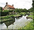
Walsham Flood Gates No 11
River Wey, River Wey Navigation path, Woking GU22 8XE, United Kingdom 
Address is taken from a point 761 yards away.

Walsham Flood Gates No 11
is a minor waterways place
on the River Wey Wey Navigation between
  Byfleet (2 miles and 5¼ furlongs
    and 1 lock
   to the north) and
  Dapdune Wharf (8 miles and 4¾ furlongs
    and 6 locks
   to the southwest).
  The nearest place in the direction of Byfleet is Walsham Bridge;
  ¼ furlongs
   away.
   
  The nearest place in the direction of Dapdune Wharf is Walsham Flood Gates Weir Entrance (Channel leading to the Weir - No Access);
  ½ furlongs
   away.
Mooring here is unrated. 
This is a lock with a rise of 0f0.
| Dodds Bridge | 1 mile, 4¾ furlongs | |
| Pyrford Marina | 1 mile, ¾ furlongs | |
| Pyrford Lock No 12 | 7¾ furlongs | |
| Pigeon House Bridge | 4½ furlongs | |
| Walsham Bridge | ¼ furlongs | |
| Walsham Flood Gates No 11 | ||
| Walsham Flood Gates Weir Entrance | ½ furlongs | |
| Newark Lock Weir Exit No 2 | 4 furlongs | |
| Newark Lock Weir Exit No 1 | 4½ furlongs | |
| Newark Lock No 10 | 5 furlongs | |
| Newark New Bridge | 6½ furlongs | |
Amenities nearby at Walsham Flood Gates Weir Entrance
- River Wey and Godalming Navigations and Dapdune Wharf — associated with River Wey
- This is the web site for the National Trust who manage the River Wey
Mouseover for more information or show routes to facility
Nearest water point
In the direction of Thames - Wey Junction
Pyrford Lock No 12 — 7¾ furlongs  and 1 lock away
On this waterway in the direction of Thames - Wey Junction
Thames Lock No 16 — 5 miles, 5 furlongs  and 5 locks away
On this waterway in the direction of Thames - Wey Junction
Chertsey Lock — 7 miles, 7¾ furlongs  and 7 locks away
Travel  to Thames - Wey Junction, then on the River Thames (below Oxford) to Chertsey Lock
Arthur's Bridge — 7 miles, 4¾ furlongs  and 8 locks away
Travel  to Woodham Junction, then on the Basingstoke Canal to Arthur's Bridge
Molesey Lock — 11 miles, 3 furlongs  and 7 locks away
Travel  to Thames - Wey Junction, then on the River Thames (below Oxford) to West End of Desborough Cut, then on the River Thames (Desborough Cut) to Thames Meadow, then on the River Thames (below Oxford) to Molesey Lock
Teddington Lock Weir Exit — 16 miles  and 9 locks away
Travel  to Thames - Wey Junction, then on the River Thames (below Oxford) to West End of Desborough Cut, then on the River Thames (Desborough Cut) to Thames Meadow, then on the River Thames (below Oxford) to Teddington Lock Weir Exit
Canal Centre Swing Bridge — 15 miles, 7 furlongs  and 30 locks away
Travel  to Woodham Junction, then on the Basingstoke Canal to Canal Centre Swing Bridge
Mytchett Bridge — 16 miles  and 30 locks away
Travel  to Woodham Junction, then on the Basingstoke Canal to Mytchett Bridge
Ash Lock Canal Depot — 19 miles, 2½ furlongs  and 31 locks away
Travel  to Woodham Junction, then on the Basingstoke Canal to Ash Lock Canal Depot
In the direction of Millmead Lock No 4
Cartbridge Wharf — 2 miles, 6¼ furlongs  and 3 locks away
On this waterway in the direction of Millmead Lock No 4
Stoke Lock No 5 — 7 miles, ½ furlongs  and 6 locks away
On this waterway in the direction of Millmead Lock No 4
Guildford Waterside Centre — 7 miles, 5 furlongs  and 7 locks away
On this waterway in the direction of Millmead Lock No 4
Dapdune Wharf — 8 miles, 4¾ furlongs  and 7 locks away
On this waterway in the direction of Millmead Lock No 4
Godalming Wharf — 13 miles, 3¾ furlongs  and 11 locks away
Travel  to Millmead Lock No 4, then on the River Wey Godalming Navigation to Godalming WharfNearest rubbish disposal
In the direction of Thames - Wey Junction
Pyrford Lock No 12 — 7¾ furlongs  and 1 lock away
On this waterway in the direction of Thames - Wey Junction
Shepperton Lock — 6 miles  and 6 locks away
Travel  to Thames - Wey Junction, then on the River Thames (below Oxford) to Shepperton Lock
Arthur's Bridge — 7 miles, 4¾ furlongs  and 8 locks away
Travel  to Woodham Junction, then on the Basingstoke Canal to Arthur's Bridge
Penton Hook Lock — 9 miles, 7 furlongs  and 8 locks away
Travel  to Thames - Wey Junction, then on the River Thames (below Oxford) to Penton Hook Lock
Molesey Lock — 11 miles, 3 furlongs  and 7 locks away
Travel  to Thames - Wey Junction, then on the River Thames (below Oxford) to West End of Desborough Cut, then on the River Thames (Desborough Cut) to Thames Meadow, then on the River Thames (below Oxford) to Molesey Lock
Bell Weir Lock — 12 miles, 5¼ furlongs  and 9 locks away
Travel  to Thames - Wey Junction, then on the River Thames (below Oxford) to Bell Weir Lock
Teddington Lock Weir Exit — 16 miles  and 9 locks away
Travel  to Thames - Wey Junction, then on the River Thames (below Oxford) to West End of Desborough Cut, then on the River Thames (Desborough Cut) to Thames Meadow, then on the River Thames (below Oxford) to Teddington Lock Weir Exit
Canal Centre Swing Bridge — 15 miles, 7 furlongs  and 30 locks away
Travel  to Woodham Junction, then on the Basingstoke Canal to Canal Centre Swing Bridge
Mytchett Bridge — 16 miles  and 30 locks away
Travel  to Woodham Junction, then on the Basingstoke Canal to Mytchett Bridge
Ash Lock Canal Depot — 19 miles, 2½ furlongs  and 31 locks away
Travel  to Woodham Junction, then on the Basingstoke Canal to Ash Lock Canal Depot
In the direction of Millmead Lock No 4
Guildford Waterside Centre — 7 miles, 5 furlongs  and 7 locks away
On this waterway in the direction of Millmead Lock No 4
Dapdune Wharf — 8 miles, 4¾ furlongs  and 7 locks away
On this waterway in the direction of Millmead Lock No 4
Godalming Wharf — 13 miles, 3¾ furlongs  and 11 locks away
Travel  to Millmead Lock No 4, then on the River Wey Godalming Navigation to Godalming WharfNearest chemical toilet disposal
In the direction of Thames - Wey Junction
Pyrford Lock No 12 — 7¾ furlongs  and 1 lock away
On this waterway in the direction of Thames - Wey Junction
Shepperton Lock — 6 miles  and 6 locks away
Travel  to Thames - Wey Junction, then on the River Thames (below Oxford) to Shepperton Lock
Arthur's Bridge — 7 miles, 4¾ furlongs  and 8 locks away
Travel  to Woodham Junction, then on the Basingstoke Canal to Arthur's Bridge
Molesey Lock — 11 miles, 3 furlongs  and 7 locks away
Travel  to Thames - Wey Junction, then on the River Thames (below Oxford) to West End of Desborough Cut, then on the River Thames (Desborough Cut) to Thames Meadow, then on the River Thames (below Oxford) to Molesey Lock
Canal Centre Swing Bridge — 15 miles, 7 furlongs  and 30 locks away
Travel  to Woodham Junction, then on the Basingstoke Canal to Canal Centre Swing Bridge
In the direction of Millmead Lock No 4
Guildford Waterside Centre — 7 miles, 5 furlongs  and 7 locks away
On this waterway in the direction of Millmead Lock No 4
Godalming Wharf — 13 miles, 3¾ furlongs  and 11 locks away
Travel  to Millmead Lock No 4, then on the River Wey Godalming Navigation to Godalming WharfNearest place to turn
In the direction of Thames - Wey Junction
Woodham Junction — 2 miles, 7¼ furlongs  and 2 locks away
On this waterway in the direction of Thames - Wey Junction
Coxes Railway Bridge Winding Hole — 4 miles, 3 furlongs  and 4 locks away
On this waterway in the direction of Thames - Wey Junction
Five Ways Junction — 5 miles, 6¼ furlongs  and 6 locks away
On this waterway in the direction of Thames - Wey Junction
Paxton Gardens Winding Hole — 4 miles, 5¼ furlongs  and 8 locks away
Travel  to Woodham Junction, then on the Basingstoke Canal to Paxton Gardens Winding Hole
Arthurs Bridge Winding Hole — 7 miles, 4½ furlongs  and 8 locks away
Travel  to Woodham Junction, then on the Basingstoke Canal to Arthurs Bridge Winding Hole
In the direction of Millmead Lock No 4
Newark Lock Weir Exit No 2 — 4 furlongs  and 1 lock away
On this waterway in the direction of Millmead Lock No 4
Newark Lock Weir Exit No 1 — 4½ furlongs  and 1 lock away
On this waterway in the direction of Millmead Lock No 4
Newark Lock Weir Entrance — 7 furlongs  and 2 locks away
On this waterway in the direction of Millmead Lock No 4
Papercourt Lock Weir Exit — 1 mile, 1¾ furlongs  and 2 locks away
On this waterway in the direction of Millmead Lock No 4
Worsfold Flood Gates Weir Entrance — 3 miles, ½ furlongs  and 4 locks away
On this waterway in the direction of Millmead Lock No 4
Worsfold Winding Hole — 3 miles, 1½ furlongs  and 4 locks away
On this waterway in the direction of Millmead Lock No 4
Triggs Lock Weir Exit — 3 miles, 4¾ furlongs  and 4 locks away
On this waterway in the direction of Millmead Lock No 4
Stoke Lock Weir Entrance — 7 miles, 4 furlongs  and 7 locks away
On this waterway in the direction of Millmead Lock No 4
Guildford Waterside Centre — 7 miles, 5 furlongs  and 7 locks away
On this waterway in the direction of Millmead Lock No 4
Dapdune Wharf — 8 miles, 4¾ furlongs  and 7 locks away
On this waterway in the direction of Millmead Lock No 4
Millmead Basin — 9 miles, 3½ furlongs  and 7 locks away
On this waterway in the direction of Millmead Lock No 4
Millmead Lock Weir Exit — 9 miles, 3½ furlongs  and 7 locks away
On this waterway in the direction of Millmead Lock No 4
St. Catherine's Lock Weir Exit — 10 miles, 3½ furlongs  and 8 locks away
Travel  to Millmead Lock No 4, then on the River Wey Godalming Navigation to St. Catherine's Lock Weir Exit
Guns Mouth Junction — 11 miles, 3¼ furlongs  and 9 locks away
Travel  to Millmead Lock No 4, then on the River Wey Godalming Navigation to Guns Mouth Junction
Unstead Lock Weir Exit — 11 miles, 4¾ furlongs  and 9 locks away
Travel  to Millmead Lock No 4, then on the River Wey Godalming Navigation to Unstead Lock Weir ExitNearest self-operated pump-out
In the direction of Thames - Wey Junction
Molesey Lock — 11 miles, 3 furlongs  and 7 locks away
Travel  to Thames - Wey Junction, then on the River Thames (below Oxford) to West End of Desborough Cut, then on the River Thames (Desborough Cut) to Thames Meadow, then on the River Thames (below Oxford) to Molesey Lock
Canal Centre Swing Bridge — 15 miles, 7 furlongs  and 30 locks away
Travel  to Woodham Junction, then on the Basingstoke Canal to Canal Centre Swing Bridge
Mytchett Bridge — 16 miles  and 30 locks away
Travel  to Woodham Junction, then on the Basingstoke Canal to Mytchett BridgeNo information
CanalPlan has no information on any of the following facilities within range:boatyard pump-out
Direction of TV transmitter (From Wolfbane Cybernetic)
 
There is no page on Wikipedia called “Walsham Flood Gates”
Wikipedia pages that might relate to Walsham Flood Gates
[Wey and Godalming Navigations]
included 12 locks. Hadfield's total presumably includes the two flood gates at Walsham and Worsfold, which protect long cuts. All of the new locks were
[North Walsham & Dilham Canal]
The North Walsham and Dilham Canal is a waterway in the English county of Norfolk. It was authorised by Parliament in 1812, but work on the construction
[List of In Our Time programmes]
Professor of the History of the Church at the University of Oxford Alexandra Walsham, Professor of Modern History at the University of Cambridge Martin Palmer
[Empire State Building]
Retrieved August 11, 2017. "NYRR Empire State Building Run-Up Crowns Dold and Walsham as Champions". New York Road Runners. February 6, 2007. Archived from the
[River Bure]
from Melton Constable to North Walsham. Despite this, wherries were using the navigation until 1912, when a disastrous flood damaged the locks. Assessment
[Thomas Hardy]
autobiographical. Some booksellers sold the novel in brown paper bags, and Walsham How, the Bishop of Wakefield, is reputed to have burnt his copy. In his
[St Albans Cathedral]
designed a celebrated astronomical clock, which was completed by William of Walsham after his death, but apparently destroyed during the Reformation. A new
[Noel Park]
much larger mission hall was opened nearby, named the Walsham-How Mission Hall after William Walsham How, leader of the Shropshire Mission to East London
[Wells-next-the-Sea]
Bosom. Today there is a large moving flood gate next to the harbour car park and many of the houses have their own flood defences. A feature of the town is
[Shrewsbury Abbey]
Madeley, Shropshire. William Henry Draper (hymnwriter) - Vicar 1889-99 Walsham How - later Bishop of Wakefield and hymnwriter - Curate 1848-51 Much of
Results of Google Search
Walsham Lock and Weir, Ripley: See 11 reviews, articles, and 2 photos of  Walsham Lock and Weir, ranked No.4 on TripAdvisor among 10 attractions in  Ripley.
TQ051601. 176. Pyrford Lock No 12. Anchor Inn and Pyrford Bridge. 5. 5. N.  TQ054591. 187. Pigeon House Bridge. 5.4. 5. N. TQ054585. 187. Walsham  Flood Gates No 11. Walsham Bridge. 6. 6. N. TQ050578. 187. Newark Lock No  10. Newark Footbridge. 6.5. 7. N. TQ042574. 186. Newark New Bridge. 6.8. 7. N.  TQ039573.
Hadfield's total presumably includes the two flood gates at Walsham and  Worsfold, which protect long cuts. All of the new locks were turf sided with timber  framework. Although the navigation was a success, with tolls soon raising £1,500  per year, disputes and litigation over financial matters occurred for some years, ...
Prepared for IOM by Matthew Walsham* ..... migration are far less clear and there  is no convincing evidence at present which links the two processes. ......  deposition on flood plains protected by embankments; and a lack of proper  operation and maintenance of sluice gates . While there is very little specific  research on the ...
The Lee Navigation is a canalised river incorporating the River Lea It runs from  Hertford Castle Weir to the River Thames at Bow Creek; its first lock is Hertford  Lock and its last Bow Locks. Contents. [hide]. 1 Name; 2 History. 2.1 Smeaton's  design; 2.2 Development. 3 Recreation; 4 Photo gallery; 5 See also; 6  Bibliography.
11. General information. Lock handles (Windlasses). Specifically for use on the  Navigations, these can be loaned or purchased from Thames Lock, Stoke Lock,  ..... Walsham Gates. • The flood gates are only closed when the river is in high  flood and navigation is suspended. • Keep well clear of. Walsham weir, above the .
The North Walsham and Dilham Canal is a waterway in the English county of  Norfolk. It was authorised by Parliament in 1812, but work on the construction of a  canal which ran parallel to a branch of the River Ant did not start until 1825. It  included six locks, which were sized to accommodate wherries, and was officially  ...
Footpath No.6 (The Hill) Starts at The Hill at the railway crossing gates on the  eastern side of the railway track at map ... Footpath No. 11 (East Beckham/Melton  Road to Parish Boundary). Starts from East ...... U14284 in a generally north north  westerly direction as far as the floodgate where it turns north north east for a ...