CanalPlanAC

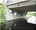
Argyll Road Bridge

 
Argyll Road, Clydebank G81 1QA, United Kingdom
 
Information about the place
Argyll Road Bridge is a minor waterways place on the Forth and Clyde Canal (Main Line) between Stockingfield Junction (Junction with the Port Dundas branch) (5 miles and 2¾ furlongs and 16 locks to the east) and Clyde Canal Junction (Junction of the River Clyde and the Forth and Clyde Canal) (4 miles and 1¼ furlongs and 4 locks to the west).
 
 
The nearest place in the direction of Stockingfield Junction is Kirkwood Avenue Footbridge; 5¾ furlongs away.
 
The nearest place in the direction of Clyde Canal Junction is Seaforth Road Footbridge; 1 furlong away.

There may be access to the towpath here.

Mooring here is unrated.

There is a bridge here which takes a minor road over the canal.


Amenities

Amenities here

 ASDA
 Aldi
 Lidl
 McDonalds
 McDonalds
 Dunelm Mill
 Dominos Pizza
 KFC
 Cashpoint
 Clydebank Oil Ltd
 Halfords
 Halfords
 Screwfix

Amenities nearby at Seaforth Road Footbridge

 Clydebank Station

Amenities nearby at Kirkwood Avenue Footbridge

 Farmfoods
 Somerfield - Clydebank - Store# 2768
 Subway Sandwich Shop
 Boots Chemist
 Cashpoint
 Cashpoint
 Lloyds
 BP
 Jet
 R D Laidlaw & Co Ltd
 Shell
 Shell Fuel Card
 Drumry Station
 Yoker Station
 
Maps
If you are a user and are logged on, or if you are actively planning a route, a map will be displayed here.
Show on external mapping site: Google | OSM | Bing
 
Additional information

"The First Sail Thru Fish and Chip Take Away" "ship" is "moored" alongside the canal, west of the bridge.

 
External websites
 Youtube — associated with Forth and Clyde Canal
The official reopening of the canal
 
Nearest facilities

Mouseover for more information or show routes to facility

Nearest place to turn

In the direction of Clyde Canal Junction

Bowling Basin3 miles, 7¾ furlongs and 3 locks away
On this waterway in the direction of Clyde Canal Junction

In the direction of River Carron - Forth and Clyde Canal Junction

Applecross Street Basin7 miles, 2 furlongs and 16 locks away
Travel to Stockingfield Junction, then on the Forth and Clyde Canal (Port Dundas Branch - Main Line) to Firhill Road Basin (northern entrance), then on the Forth and Clyde Canal (Port Dundas Branch - Firhill Road Basin) to Firhill Road Basin (southern entrance), then on the Forth and Clyde Canal (Port Dundas Branch - Main Line) to Applecross Street Basin
Craighall Road Basin Western Winding Hole7 miles, 6¼ furlongs and 17 locks away
Travel to Stockingfield Junction, then on the Forth and Clyde Canal (Port Dundas Branch - Main Line) to Firhill Road Basin (northern entrance), then on the Forth and Clyde Canal (Port Dundas Branch - Firhill Road Basin) to Firhill Road Basin (southern entrance), then on the Forth and Clyde Canal (Port Dundas Branch - Main Line) to Craighall Road Basin Western Winding Hole
Craighall Road Basin7 miles, 6½ furlongs and 17 locks away
Travel to Stockingfield Junction, then on the Forth and Clyde Canal (Port Dundas Branch - Main Line) to Firhill Road Basin (northern entrance), then on the Forth and Clyde Canal (Port Dundas Branch - Firhill Road Basin) to Firhill Road Basin (southern entrance), then on the Forth and Clyde Canal (Port Dundas Branch - Main Line) to Craighall Road Basin
Port Dundas Basin8 miles, ¾ furlongs and 18 locks away
Travel to Stockingfield Junction, then on the Forth and Clyde Canal (Port Dundas Branch - Main Line) to Firhill Road Basin (northern entrance), then on the Forth and Clyde Canal (Port Dundas Branch - Firhill Road Basin) to Firhill Road Basin (southern entrance), then on the Forth and Clyde Canal (Port Dundas Branch - Main Line) to Port Dundas Basin
Luggiebank Road Winding Hole12 miles, 2¾ furlongs and 16 locks away
On this waterway in the direction of River Carron - Forth and Clyde Canal Junction
Auchinstarry Winding Hole17 miles, 5 furlongs and 16 locks away
On this waterway in the direction of River Carron - Forth and Clyde Canal Junction
Craigmarloch Basin18 miles, 3½ furlongs and 16 locks away
On this waterway in the direction of River Carron - Forth and Clyde Canal Junction
Wyndford Lock Winding Hole19 miles, 6¼ furlongs and 16 locks away
On this waterway in the direction of River Carron - Forth and Clyde Canal Junction

No information

CanalPlan has no information on any of the following facilities within range:
water point
rubbish disposal
chemical toilet disposal
self-operated pump-out
boatyard pump-out
Direction of TV transmitter (From Wolfbane Cybernetic)
 
 
Geograph
 
Wikipedia

There is no page on Wikipedia called “Argyll Road Bridge”

Wikipedia pages that might relate to Argyll Road Bridge
[Aray Bridge] Aray Bridge, also known as Inveraray Bridge, is a stone two-arch public road bridge on the Inveraray Castle estate near Inveraray in Argyll and Bute, Scotland [Clachan Bridge] Clachan Bridge is a simple, single-arched, hump-backed, masonry bridge spanning the Clachan Sound, 13 kilometres (8 mi) southwest of Oban in Argyll, Scotland [Kilbride Bridge] Kilbride Bridge is a bridge in Dunoon, Argyll and Bute, Scotland. A Category C listed structure, it carries the traffic of Auchamore Road. It is made of [Argyll and Bute] Coordinates: 56°06′N 5°30′W / 56.1°N 5.5°W / 56.1; -5.5 Argyll and Bute (Scots: Argyll an Buit; Scottish Gaelic: Earra-Ghàidheal agus Bòd, pronounced [ɛrˠəˈɣɛːəlˠ̪ [Inveraray] the Aray") is a town in Argyll and Bute, Scotland. It is on the western shore of Loch Fyne, near its head, and on the A83 road. It is a former royal burgh [Bridge of Awe] The Bridge of Awe (Scottish Gaelic: Drochaid Abha) was a triple-spanned arch bridge near Taynuilt in Argyll, Scotland. In 1753 the Bonawe Iron Furnace [Minard, Argyll] and Bridge at Minard "Minard, Argyll and Bute". Ordnance Survey. Ordnance Survey 2018. Retrieved 17 February 2018. Frank Arneil Walker (2000). Argyll and [Argyll] Argyll (/ɑːrˈɡaɪl/; archaically Argyle, Earra-Ghàidheal in modern Gaelic, pronounced [ˈaːrˠəɣɛː.əl̪ˠ]), sometimes called Argyllshire, is a historic county [Ballachulish Bridge] Ballachulish (Argyll) and North Ballachulish (Inverness-shire). It carries the A82 road, the main route between Glasgow and Inverness. The bridge was built [Connel Bridge] Connel Bridge is a cantilever bridge that spans Loch Etive at Connel in Scotland. The bridge takes the A828 road across the narrowest part of the loch
 
Google

Results of Google Search

2020-05-20 Argyll Road Bridge Span StreetView – TransEd Valley ...
May 20, 2020 ... 2020-05-20 Argyll Road Bridge Span StreetView. Stay in Touch. Get the latest updates on progress reports, disruptions and Valley Line LRT ...
82nd Avenue Over Argyll Road - Rapid-Span Group
Jul 29, 2017 ... Construction of a municipal bridge replacement over an active roadway in Edmonton. Rapid-Span fabricated and erected the steel structure.
File:Sun reflecting off Argyll Road bridge - geograph.org.uk - 759126 ...
English: Sun reflecting off Argyll Road bridge The evening sun glints on the wall of the bridge ovcer the canal. Date, 6 April 2008. Source, From geograph.org.uk.
Valley Line LRT Progress in Photos | SkyriseEdmonton
Nov 26, 2019 ... The final bridge segment over Argyll Road was lifted into place earlier this month. Captured also by Kaizen, the new bridge will carry trains over ...
File:Argyll Road bridge - geograph.org.uk - 1469755.jpg - Wikimedia ...
Mar 9, 2020 ... English: Argyll Road bridge A new bridge over the restored Forth and Clyde Canal. Note the mirrors on the opposite wall from the footpath.
Hawrelak - River Valley Trails - Mill Creek Ravine - Argyll Road (Tim ...
Nov 21, 2013 ... RMSSC- Dark Blue Ride - Hawrelak Park, East on River Valley Trails (gravel) - MultiUse Bridge by LRT Track - River Valley Rd - Irene Parlby ...
Our Roads - Regulations and Limits
Argyll and Bute Council (Various Roads, Tobermory)(Temporary Traffic ... B8071 Arinagour-Ballyhough Road as carried by Cliad Bridge, Island of Coll.
Argyll Road Bridge and the Debra Rose
Argyll Road Bridge and the Debra Rose. Forth & Clyde Canal, 4 miles. Date taken: 2007-11-10.
Clachan Bridge - Wikipedia
The Clachan Bridge is a simple, single-arched, hump-backed, masonry bridge spanning the Clachan Sound, 13 kilometres (8 mi) southwest of Oban in Argyll, Scotland. ... The bridge is still in use today, forming part of the B844 road, and is in the care of Historic Scotland. Because the Clachan Sound connects at both ends to ...