CanalPlanAC

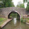
Yarnton Lane Bridge No 228

 
Kidlington half a mile north
Yarnton Road, Kidlington OX5, United Kingdom
 
Information about the place
Yarnton Lane Bridge No 228 is near or in the village of Kidlington half a mile north and is on the Oxford Canal (Southern Section - Main Line) between Wolvercote Junction (Junction of Duke's Cut with Oxford Canal) (1 mile and 6½ furlongs and 2 locks to the south) and Sparrowgap Bridge No 223 (1 mile and 4½ furlongs and 1 lock to the northwest).
 
 
The nearest place in the direction of Wolvercote Junction is Kidlington Green Lock No 43; 3¼ furlongs away.
 
The nearest place in the direction of Sparrowgap Bridge No 223 is Bullers Bridge No 227; 1¼ furlongs away.

There is access (suitable for wheels) to the towpath here.

Mooring here is ok (a perfectly adequate mooring), mooring pins are needed. Access to bus stops by football ground.

There is a bridge here which takes a minor road over the canal.


Amenities

Amenities nearby at Kidlington Green Lock No 43

 Sainsbury's
 Sainsburys
 Sainsburys - Oxford Road - Kidlington OX5 2PE
 Mayflower
 Chinese Takeaway
 Kidlington, Sainsburys
 Cashpoint
 Lloyds
 Sainsburys Fuel

Amenities nearby at Bullers Bridge No 227

 Budgens
 Kidlington, Ovisher Tandoori
 Red Lion
 Dominos Pizza
 Fish & Chips
 Indian Takeaway
 Subway Sandwich Shop
 Cashpoint
 Lloyds
 Lloyds Bank
 NatWest
 BP
 Fraser Group
 ReD Fuel Card
 Texaco
 Yarnton Service Station
 
Maps
If you are a user and are logged on, or if you are actively planning a route, a map will be displayed here.
Show on external mapping site: Google | OSM | Bing
 
Additional information

Shops including good Co-op approx half mile from bridge towards Kidlington

 
Photos
 
External websites
 Oxford Canal Walk - Part One - Oxford to Thrupp - YouTube — associated with Oxford Canal
A walk along the Oxford Canal (Southern Section) from Oxford to Thrupp Wide
 
Nearest facilities

Mouseover for more information or show routes to facility

Nearest water point

In the direction of Napton Junction

Langford Lane Bridge No 2241 mile, 2¼ furlongs and 1 lock away
On this waterway in the direction of Napton Junction
Aubreys Lift Bridge No 2211 mile, 7¾ furlongs and 1 lock away
On this waterway in the direction of Napton Junction
Thrupp Cruising Club1 mile, 7¾ furlongs and 1 lock away
On this waterway in the direction of Napton Junction
Heyford Wharf Bridge No 2069 miles, 4 furlongs and 6 locks away
On this waterway in the direction of Napton Junction
Heyford Wharf9 miles, 4¼ furlongs and 6 locks away
On this waterway in the direction of Napton Junction
Aynho Wharf15 miles, 4½ furlongs and 9 locks away
On this waterway in the direction of Napton Junction

In the direction of End of Hythe Bridge Arm

Wolvercote Junction Water Point1 mile, 5½ furlongs and 1 lock away
On this waterway in the direction of End of Hythe Bridge Arm
Wolvercote Sanitary Station2 miles, 2 furlongs and 2 locks away
On this waterway in the direction of End of Hythe Bridge Arm
St Edwards Lift Bridge No 2383 miles, 2¾ furlongs and 3 locks away
On this waterway in the direction of End of Hythe Bridge Arm
Oxford Visitor Moorings4 miles, 7 furlongs and 3 locks away
On this waterway in the direction of End of Hythe Bridge Arm
Eynsham Lock5 miles, 1¼ furlongs and 3 locks away
Travel to Wolvercote Junction, then on the Oxford Canal (Duke's Cut) to Duke's Cut Junction, then on the River Thames (above Oxford) to Eynsham Lock
Abingdon Lock13 miles, 6 furlongs and 7 locks away
Travel to Isis Lock Junction, then on the River Thames (Sheepwash Channel) to Sheepwash Channel Junction, then on the River Thames (above Oxford) to Osney Bridge, then on the River Thames (below Oxford) to Abingdon Lock
Shifford Lock15 miles, 2 furlongs and 6 locks away
Travel to Wolvercote Junction, then on the Oxford Canal (Duke's Cut) to Duke's Cut Junction, then on the River Thames (above Oxford) to Shifford Lock
Abingdon Bridge Marine14 miles, 1¾ furlongs and 8 locks away
Travel to Isis Lock Junction, then on the River Thames (Sheepwash Channel) to Sheepwash Channel Junction, then on the River Thames (above Oxford) to Osney Bridge, then on the River Thames (below Oxford) to Abingdon Bridge Marine

Nearest rubbish disposal

In the direction of Napton Junction

Aubreys Lift Bridge No 2211 mile, 7¾ furlongs and 1 lock away
On this waterway in the direction of Napton Junction
Thrupp Cruising Club1 mile, 7¾ furlongs and 1 lock away
On this waterway in the direction of Napton Junction
Heyford Wharf Bridge No 2069 miles, 4 furlongs and 6 locks away
On this waterway in the direction of Napton Junction
Heyford Wharf9 miles, 4¼ furlongs and 6 locks away
On this waterway in the direction of Napton Junction
Aynho Wharf15 miles, 4½ furlongs and 9 locks away
On this waterway in the direction of Napton Junction

In the direction of End of Hythe Bridge Arm

Wolvercote Sanitary Station2 miles, 2 furlongs and 2 locks away
On this waterway in the direction of End of Hythe Bridge Arm
Eynsham Lock5 miles, 1¼ furlongs and 3 locks away
Travel to Wolvercote Junction, then on the Oxford Canal (Duke's Cut) to Duke's Cut Junction, then on the River Thames (above Oxford) to Eynsham Lock
Abingdon Lock13 miles, 6 furlongs and 7 locks away
Travel to Isis Lock Junction, then on the River Thames (Sheepwash Channel) to Sheepwash Channel Junction, then on the River Thames (above Oxford) to Osney Bridge, then on the River Thames (below Oxford) to Abingdon Lock
Rushey Lock19 miles, 3 furlongs and 7 locks away
Travel to Wolvercote Junction, then on the Oxford Canal (Duke's Cut) to Duke's Cut Junction, then on the River Thames (above Oxford) to Rushey Lock

Nearest chemical toilet disposal

In the direction of Napton Junction

Thrupp Cruising Club1 mile, 7¾ furlongs and 1 lock away
On this waterway in the direction of Napton Junction

In the direction of End of Hythe Bridge Arm

Wolvercote Sanitary Station2 miles, 2 furlongs and 2 locks away
On this waterway in the direction of End of Hythe Bridge Arm
Eynsham Lock5 miles, 1¼ furlongs and 3 locks away
Travel to Wolvercote Junction, then on the Oxford Canal (Duke's Cut) to Duke's Cut Junction, then on the River Thames (above Oxford) to Eynsham Lock
Abingdon Lock13 miles, 6 furlongs and 7 locks away
Travel to Isis Lock Junction, then on the River Thames (Sheepwash Channel) to Sheepwash Channel Junction, then on the River Thames (above Oxford) to Osney Bridge, then on the River Thames (below Oxford) to Abingdon Lock
Rushey Lock19 miles, 3 furlongs and 7 locks away
Travel to Wolvercote Junction, then on the Oxford Canal (Duke's Cut) to Duke's Cut Junction, then on the River Thames (above Oxford) to Rushey Lock

Nearest place to turn

In the direction of Napton Junction

Thrupp Wide1 mile, 7¾ furlongs and 1 lock away
On this waterway in the direction of Napton Junction
Shipton Weir Junction3 miles, ¼ furlongs and 2 locks away
On this waterway in the direction of Napton Junction
Enslow Winding Hole4 miles, 4½ furlongs and 3 locks away
On this waterway in the direction of Napton Junction
Kirtlington Winding Hole6 miles, 1¾ furlongs and 4 locks away
On this waterway in the direction of Napton Junction
The Cleeves Winding Hole9 miles, ¼ furlongs and 6 locks away
On this waterway in the direction of Napton Junction
Heyford Wharf9 miles, 4¼ furlongs and 6 locks away
On this waterway in the direction of Napton Junction

In the direction of End of Hythe Bridge Arm

Wolvercote Junction1 mile, 6½ furlongs and 2 locks away
On this waterway in the direction of End of Hythe Bridge Arm
Bypass Reservoir Junction2 miles, ¼ furlongs and 3 locks away
Travel to Wolvercote Junction, then on the Oxford Canal (Duke's Cut) to Bypass Reservoir Junction
Duke's Cut Junction2 miles, 4¾ furlongs and 3 locks away
Travel to Wolvercote Junction, then on the Oxford Canal (Duke's Cut) to Duke's Cut Junction
Hythe Bridge Arm Winding Hole4 miles, 6¼ furlongs and 3 locks away
On this waterway in the direction of End of Hythe Bridge Arm
End of Hythe Bridge Arm4 miles, 7¼ furlongs and 3 locks away
On this waterway in the direction of End of Hythe Bridge Arm
Thames - Wharf Stream Junction4 miles, 7½ furlongs and 3 locks away
Travel to Wolvercote Junction, then on the Oxford Canal (Duke's Cut) to Duke's Cut Junction, then on the River Thames (above Oxford) to Thames - Wharf Stream Junction
Castle Mill Stream Junction4 miles, 6¾ furlongs and 4 locks away
Travel to Isis Lock Junction, then on the River Thames (Sheepwash Channel) to Castle Mill Stream Junction
Sheepwash Channel Junction4 miles, 7½ furlongs and 4 locks away
Travel to Isis Lock Junction, then on the River Thames (Sheepwash Channel) to Sheepwash Channel Junction
Bossoms Boat Yard5 miles, 2 furlongs and 5 locks away
Travel to Wolvercote Junction, then on the Oxford Canal (Duke's Cut) to Duke's Cut Junction, then on the River Thames (above Oxford) to Bossoms Boat Yard
Osney Lock Weir Exit5 miles, 2¼ furlongs and 5 locks away
Travel to Isis Lock Junction, then on the River Thames (Sheepwash Channel) to Sheepwash Channel Junction, then on the River Thames (above Oxford) to Osney Bridge, then on the River Thames (below Oxford) to Osney Lock Weir Exit
Pinkhill Lock Weir Exit6 miles, 3½ furlongs and 4 locks away
Travel to Wolvercote Junction, then on the Oxford Canal (Duke's Cut) to Duke's Cut Junction, then on the River Thames (above Oxford) to Pinkhill Lock Weir Exit
Thames - Cherwell Junction6 miles, 4¼ furlongs and 5 locks away
Travel to Isis Lock Junction, then on the River Thames (Sheepwash Channel) to Sheepwash Channel Junction, then on the River Thames (above Oxford) to Osney Bridge, then on the River Thames (below Oxford) to Thames - Cherwell Junction
Iffley Lock Weir Entrance No 17 miles, 3¾ furlongs and 5 locks away
Travel to Isis Lock Junction, then on the River Thames (Sheepwash Channel) to Sheepwash Channel Junction, then on the River Thames (above Oxford) to Osney Bridge, then on the River Thames (below Oxford) to Iffley Lock Weir Entrance No 1
Iffley Lock Weir Exit No 17 miles, 4¾ furlongs and 6 locks away
Travel to Isis Lock Junction, then on the River Thames (Sheepwash Channel) to Sheepwash Channel Junction, then on the River Thames (above Oxford) to Osney Bridge, then on the River Thames (below Oxford) to Iffley Lock Weir Exit No 1

Nearest self-operated pump-out

In the direction of Napton Junction

Aubreys Lift Bridge No 2211 mile, 7¾ furlongs and 1 lock away
On this waterway in the direction of Napton Junction
Thrupp Cruising Club1 mile, 7¾ furlongs and 1 lock away
On this waterway in the direction of Napton Junction

In the direction of End of Hythe Bridge Arm

Eynsham Lock5 miles, 1¼ furlongs and 3 locks away
Travel to Wolvercote Junction, then on the Oxford Canal (Duke's Cut) to Duke's Cut Junction, then on the River Thames (above Oxford) to Eynsham Lock
Abingdon Lock13 miles, 6 furlongs and 7 locks away
Travel to Isis Lock Junction, then on the River Thames (Sheepwash Channel) to Sheepwash Channel Junction, then on the River Thames (above Oxford) to Osney Bridge, then on the River Thames (below Oxford) to Abingdon Lock
Rushey Lock19 miles, 3 furlongs and 7 locks away
Travel to Wolvercote Junction, then on the Oxford Canal (Duke's Cut) to Duke's Cut Junction, then on the River Thames (above Oxford) to Rushey Lock

Nearest boatyard pump-out

In the direction of Napton Junction

Enslow Wharf4 miles, 3¼ furlongs and 3 locks away
On this waterway in the direction of Napton Junction
Heyford Wharf9 miles, 4¼ furlongs and 6 locks away
On this waterway in the direction of Napton Junction
Aynho Wharf15 miles, 4½ furlongs and 9 locks away
On this waterway in the direction of Napton Junction
Twyford Wharf19 miles, 4 furlongs and 12 locks away
On this waterway in the direction of Napton Junction

In the direction of End of Hythe Bridge Arm

Oxford Cruisers Marina6 miles, 1 furlong and 4 locks away
Travel to Wolvercote Junction, then on the Oxford Canal (Duke's Cut) to Duke's Cut Junction, then on the River Thames (above Oxford) to Oxford Cruisers Marina
Abingdon Bridge Marine14 miles, 1¾ furlongs and 8 locks away
Travel to Isis Lock Junction, then on the River Thames (Sheepwash Channel) to Sheepwash Channel Junction, then on the River Thames (above Oxford) to Osney Bridge, then on the River Thames (below Oxford) to Abingdon Bridge Marine
Direction of TV transmitter (From Wolfbane Cybernetic)
 
 
Geograph
 
Wikipedia

There is no page on Wikipedia called “Yarnton Lane Bridge”

Wikipedia pages that might relate to Yarnton Lane Bridge
[A40 road] February 2015, the Witney Oxford Transport Group proposed the reopening of Yarnton railway station as an alternative to improvements to the A40 road proposed [Gasworks Bridge] Gasworks Bridge, also known as the Old Gasworks Bridge, is an iron bridge across the River Thames at Oxford in England. It is a pedestrian bridge linking [River Thames] existing bridges both in London and along the length of the river. These included Putney Bridge, Westminster Bridge, Datchet Bridge, Windsor Bridge and Sonning [Oxford, Witney and Fairford Railway] only between Witney and Fairford. The junction with the main line was at Yarnton, north of Oxford. The Great Western Railway worked the two companies' lines [Oxford Road Halt railway station] Buckinghamshire Junction Railway (often known as the Yarnton Loop) was opened, between Oxford Road Junction and Yarnton Junction. The former junction was constructed [Cotswold Line] to converge from the east. About 4 miles (6.4 km) after Oxford station, Yarnton station was in the short stretch between here and where the Witney Railway [East West Rail] Brickhill (Brickhill Street in Milton Keynes to the A5) will be replaced with a bridge. In May 2014 Network Rail announced that the line will be opened to 125 mph [Road surface] limestone-surfaced road, thought to date back to the Bronze Age, was found at Yarnton in Oxfordshire, Britain. Applying gravel, or "metalling", has had two distinct [List of closed railway lines in the United Kingdom] October 1963 Fairford branch line Oxford, Witney and Fairford Railway (GWR) Yarnton to Fairford, via Witney 18 June 1962 (to passengers) 2 November 1970 (to [South East England] superconducting magnets for NMR applications on the A44 next to the railway at Yarnton. Solid State Logic (mixing consoles) is at Begbroke on the A44, which has
 
Google