Burnley Wharf
Part of the Burnley Weavers Triangle including the Toll House museum
Also known as: Inn on the Wharf
Weavers Triangle, Nelson Square, Burnley BB11 1LA, United Kingdom

Burnley Wharf
is a place on the waterways
on the Leeds and Liverpool Canal (Main Line - Wigan to Leeds) between
Feniscowles Bridge No 93B (19 miles and 4½ furlongs
and 6 locks
to the west) and
Salterforth Bridge No 151 (Salterforth village 200 yards northeast) (10 miles and 7 furlongs
and 7 locks
to the northeast).
The nearest place in the direction of Feniscowles Bridge No 93B is Nelson Square Winding Hole;
½ furlongs
away.
The nearest place in the direction of Salterforth Bridge No 151 is Manchester Road Bridge No 130B;
½ furlongs
away.
Mooring here is tolerable (it's just about possible if really necessary). Mooring is available against a concrete bank with a busy towpath which is close to pub/catering.
| Mitre Bridge No 129B | 4¾ furlongs | |
| Sandygate Square Footbridge | 3¾ furlongs | |
| Burnley Wharf Bridge No 130 | 3¼ furlongs | |
| Walker Hey Footbridge No 130A | 1 furlong | |
| Nelson Square Winding Hole | ½ furlongs | |
| Burnley Wharf | ||
| Manchester Road Bridge No 130B | ½ furlongs | |
| Centenary Way No 130BB | 1 furlong | |
| Healey Wood Footbridge No 130C | 1½ furlongs | |
| Finsley Footbridge | 3 furlongs | |
| Former Burnley BW Depot (disused) | 3 furlongs | |
Amenities here
Amenities nearby at Manchester Road Bridge No 130B
Amenities nearby at Nelson Square Winding Hole
Good access to Manchester Road and Burnley centre.
There are no links to external websites from here.
Why not log in and add some (select "External websites" from the menu (sometimes this is under "Edit"))?
Mouseover for more information or show routes to facility
Nearest water point
In the direction of Leeds Bridge
Reedley Marina — 3 miles, 1½ furlongs away
On this waterway in the direction of Leeds Bridge
Barrowford Top Lock No 45 — 7 miles, 2½ furlongs and 6 locks away
On this waterway in the direction of Leeds Bridge
Foulridge Wharf — 9 miles, 1¾ furlongs and 7 locks away
On this waterway in the direction of Leeds Bridge
Salterforth Bridge No 151 — 10 miles, 7 furlongs and 7 locks away
On this waterway in the direction of Leeds Bridge
Lower Park Marina — 11 miles, 4½ furlongs and 7 locks away
On this waterway in the direction of Leeds Bridge
Greenberfield Services — 13 miles, 1 furlong and 7 locks away
On this waterway in the direction of Leeds Bridge
East Marton Visitor Moorings — 16 miles, ¼ furlongs and 10 locks away
On this waterway in the direction of Leeds Bridge
Priest Holme Water Point — 18 miles, 5¾ furlongs and 16 locks away
On this waterway in the direction of Leeds Bridge
Gargrave Services — 19 miles, 7¾ furlongs and 19 locks away
On this waterway in the direction of Leeds Bridge
In the direction of Wigan Junction
Rose Grove Services — 2 miles, 1½ furlongs away
On this waterway in the direction of Wigan Junction
Blackburn Lock Sanitary Station — 16 miles, 8 furlongs and 4 locks away
On this waterway in the direction of Wigan JunctionNearest rubbish disposal
In the direction of Leeds Bridge
Barrowford Lock No 47 — 7 miles, 1½ furlongs and 4 locks away
On this waterway in the direction of Leeds Bridge
Foulridge Wharf — 9 miles, 1¾ furlongs and 7 locks away
On this waterway in the direction of Leeds Bridge
Salterforth Bridge No 151 — 10 miles, 7 furlongs and 7 locks away
On this waterway in the direction of Leeds Bridge
Lower Park Marina — 11 miles, 4½ furlongs and 7 locks away
On this waterway in the direction of Leeds Bridge
Greenberfield Services — 13 miles, 1 furlong and 7 locks away
On this waterway in the direction of Leeds Bridge
Gargrave Services — 19 miles, 7¾ furlongs and 19 locks away
On this waterway in the direction of Leeds Bridge
In the direction of Wigan Junction
Rose Grove Services — 2 miles, 1½ furlongs away
On this waterway in the direction of Wigan Junction
Blackburn Lock Sanitary Station — 16 miles, 8 furlongs and 4 locks away
On this waterway in the direction of Wigan JunctionNearest chemical toilet disposal
In the direction of Leeds Bridge
Barrowford Top Lock No 45 — 7 miles, 2½ furlongs and 6 locks away
On this waterway in the direction of Leeds Bridge
Foulridge Wharf — 9 miles, 1¾ furlongs and 7 locks away
On this waterway in the direction of Leeds Bridge
Salterforth Bridge No 151 — 10 miles, 7 furlongs and 7 locks away
On this waterway in the direction of Leeds Bridge
Lower Park Marina — 11 miles, 4½ furlongs and 7 locks away
On this waterway in the direction of Leeds Bridge
Greenberfield Services — 13 miles, 1 furlong and 7 locks away
On this waterway in the direction of Leeds Bridge
Gargrave Services — 19 miles, 7¾ furlongs and 19 locks away
On this waterway in the direction of Leeds Bridge
In the direction of Wigan Junction
Rose Grove Services — 2 miles, 1½ furlongs away
On this waterway in the direction of Wigan Junction
Blackburn Lock Sanitary Station — 16 miles, 8 furlongs and 4 locks away
On this waterway in the direction of Wigan JunctionNearest place to turn
In the direction of Leeds Bridge
Sandholme Aqueduct Winding Hole — 1 mile, 2¾ furlongs away
On this waterway in the direction of Leeds Bridge
Winding Hole North of Burnley Embankment — 1 mile, 4¼ furlongs away
On this waterway in the direction of Leeds Bridge
Burley Lane Winding Hole — 2 miles, 4¾ furlongs away
On this waterway in the direction of Leeds Bridge
Hawks House Winding Hole — 3 miles, 6 furlongs away
On this waterway in the direction of Leeds Bridge
Hodge Bank Winding Hole — 5 miles, 7¾ furlongs away
On this waterway in the direction of Leeds Bridge
Wanless Bridge Winding Hole — 7 miles, 6¾ furlongs and 7 locks away
On this waterway in the direction of Leeds Bridge
Foulridge Wharf Winding Hole — 9 miles, 2 furlongs and 7 locks away
On this waterway in the direction of Leeds Bridge
Long Ing Bridge Winding Hole — 12 miles, ¼ furlongs and 7 locks away
On this waterway in the direction of Leeds Bridge
In the direction of Wigan Junction
Nelson Square Winding Hole — ½ furlongs away
On this waterway in the direction of Wigan Junction
Old Rose Grove Winding Hole — 2 miles, 3¾ furlongs away
On this waterway in the direction of Wigan Junction
Hapton Winding Hole — 4 miles, 2 furlongs away
On this waterway in the direction of Wigan Junction
Shuttleworth Winding Hole — 5 miles, 1 furlong away
On this waterway in the direction of Wigan Junction
Clough Bank Winding Hole — 5 miles, 7¼ furlongs away
On this waterway in the direction of Wigan Junction
Whalley Road Bridge Winding Hole — 7 miles, 5½ furlongs away
On this waterway in the direction of Wigan Junction
Church Kirk Bridge Winding Hole — 9 miles, 2 furlongs away
On this waterway in the direction of Wigan Junction
Railway Bridge No 110B Winding Hole — 9 miles, 7½ furlongs away
On this waterway in the direction of Wigan Junction
Dunkenhalgh Aqueduct Winding Hole — 10 miles, 7¾ furlongs away
On this waterway in the direction of Wigan Junction
Rishton Winding Hole — 11 miles, 1¼ furlongs away
On this waterway in the direction of Wigan Junction
Trident Way Winding Hole — 13 miles, 5¼ furlongs away
On this waterway in the direction of Wigan Junction
Eanam Bridge Winding Hole — 15 miles, 6¼ furlongs away
On this waterway in the direction of Wigan JunctionNearest self-operated pump-out
In the direction of Wigan Junction
Rose Grove Services — 2 miles, 1½ furlongs away
On this waterway in the direction of Wigan JunctionNearest boatyard pump-out
In the direction of Leeds Bridge
Reedley Marina — 3 miles, 1½ furlongs away
On this waterway in the direction of Leeds Bridge
Lower Park Marina — 11 miles, 4½ furlongs and 7 locks away
On this waterway in the direction of Leeds BridgeDirection of TV transmitter (From Wolfbane Cybernetic)
Over the Border from Scribblings from the Mintball posted Wednesday the 9th of July, 1980
Onwards and upwards from Scribblings from the Mintball posted Tuesday the 8th of July, 1980
There is no page on Wikipedia called “Burnley Wharf”
Wikipedia pages that might relate to Burnley Wharf
[Burnley]
Burnley (/ˈbɜːrnli/) is a town in Lancashire, England, with a 2001 population of 73,021. It is 21 miles (34 km) north of Manchester and 20 miles (32 km)
[Leeds and Liverpool Canal]
eastern Burnley. At a cost of £40,000 (about £3.65 million in 2014) the tunnel became the most expensive single item in the whole project. At Burnley, rather
[Weavers' Triangle]
The Weavers' Triangle is an area of Burnley in Lancashire, England consisting mostly of 19th-century industrial buildings at the western side of town
[Burnley Embankment]
The Burnley Embankment is an embankment carrying the Leeds and Liverpool Canal across the Calder and Brun valleys in Burnley, Lancashire. Also known as
[Listed buildings in Burnley]
canal wharf, Burnley (1244894)", National Heritage List for England, retrieved 17 January 2015 Historic England, "Sandygate Canal Bridge, Burnley (1244977)"
[Hebden Bridge]
Hebden Bridge (Heptenbryge) started as a settlement where the Halifax to Burnley packhorse route dropped into the valley and crossed the River Hebden where
[Burnley Coalfield]
The Burnley Coalfield is the most northerly portion of the Lancashire Coalfield. Surrounding Burnley, Nelson, Blackburn and Accrington, it is separated
[West Ham United F.C.]
Ironworks Gazette of June 1895. Thames Ironworks was based in Leamouth Wharf in Blackwall and Canning Town on both banks of the River Lea, where the
[Chester]
1985), rugby player England and Northampton saints Tom Heaton (born 1986), Burnley F.C. goalkeeper Danny Murphy (born 1977), footballer and former England
[List of mills in Lancashire]
1982, pp. 190,193 http://www.gracesguide.co.uk/1891_Cotton_Mills_in_Burnley#Burnley_.28p73.29 Archived 2016-05-04 at the Wayback Machine Graces Guide 1891


![Burnley Wharf, Leeds and Liverpool Canal. Burnley Wharf is a fine collection of nineteenth century stone and grey slate canal side warehouses and workshops. This complex has been sensitively brought back into use as the Inn on the Wharf, the Weavers’ Triangle Visitor Centre (occupying the former Toll and Wharf Master’s House) 
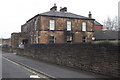
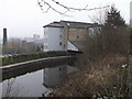
and office accommodation.The canal at this point is quite wide which allowed the barges to turn round and various goods such as coal and cotton would have been loaded and unloaded here. There is a group of three adjoining warehouses, each of a different age and style, on the northern side of the canal at Manchester Road Wharf.Nearest to the camera, at SD8383 3232, is a four storey canal warehouse dating from 1841-4 which is now used as a store. It has a very prominent full-width wooden canopy over the lower 2 floors carried on cantilevered cast-iron I-beams and short cast-iron columns. There is a central 4-stage loading bay with a hoist-housing rising through the canopy. The building is grade II-listed by English Heritage (English Heritage Building ID: 467116 http://www.britishlistedbuildings.co.uk/en-467116-north-warehouse-to-rear-of-wharf-masters British Listed Buildings).Next a recently restored, single storey warehouse at SD8386 3230 which was added later, probably mid nineteenth century. This also has a prominent full-width wooden canopy carried on 4 full-height cast-iron columns and is also a grade II listed building (English Heritage Building ID: 467115 http://www.britishlistedbuildings.co.uk/en-467115-centre-warehouse-to-rear-of-wharf-master British Listed Buildings). This building houses the remains of an old crane (see [[[4350592]]]).The third building, at SD8387 3228, is a two-storey stone warehouse. This was actually the earliest of the three warehouses, dating from c1796-1800. Whereas the later warehouses were open-fronted structures built to face the canal, this one was built parallel to the canal allowing direct unloading from the barges using catshead cranes. It was converted into a bar and restaurant (Inn on the Wharf) when the wharf was restored in the 1990s. This also is a Grade II listed building (English Heritage Building ID: 467117 http://www.britishlistedbuildings.co.uk/en-467117-south-warehouse-to-rear-of-wharf-masters British Listed Buildings)Beyond the warehouse at SD8388 3227, adjoining the bridge, is the former Toll and Wharf Master’s House; another Grade II listed building dating from ca1850 (English Heritage Building ID: 467114 http://www.britishlistedbuildings.co.uk/en-467114-wharf-masters-house-and-toll-office-at-m British Listed Buildings). This is now used as The Weavers’ Triangle Visitor Centre. The bridge is also Grade II-listed (English Heritage Building ID: 467130 http://www.britishlistedbuildings.co.uk/en-467130-canal-bridge-lancashire British Listed Buildings). by David Dixon – 15 February 2015](https://s0.geograph.org.uk/geophotos/04/35/09/4350912_ca6779e2_120x120.jpg)


![Burnley Wharf, 1986. An old view from the mid 1980s of the canalside buildings by the wharf. A more recent view [[4350591]] shows that little has changed except in the distance a factory building and clock tower have gone. by Des Blenkinsopp – 1986](https://s0.geograph.org.uk/geophotos/06/80/52/6805212_ad33cb5c_120x120.jpg)
![Burnley Wharf, Leeds and Liverpool Canal. A narrow boat at Burnley Wharf.The toll house is in the centre background. This is now part of the visitor's centre for the Weavers' Triangle.This view is looking in the opposite direction to [[528590]]. by Ian Taylor – 13 September 2009](https://s3.geograph.org.uk/geophotos/01/49/27/1492719_9d02e1d7_120x120.jpg)


