CanalPlanAC

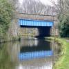
Northway Bridge No 12A

 
Northway, Sefton L31 6DD, United Kingdom (A59)
 
Information about the place
Northway Bridge No 12A is a minor waterways place on the Leeds and Liverpool Canal (Main Line - Liverpool to Wigan) between Stanley Dock Cut Junction (11 miles and 3¾ furlongs to the southwest) and Lathom Junction (Junction with Leeds and Liverpool - Rufford Branch) (12 miles and 4 furlongs to the northeast).
 
 
The nearest place in the direction of Stanley Dock Cut Junction is Whinny Brook Aqueduct; 1¾ furlongs away.
 
The nearest place in the direction of Lathom Junction is Red Lion Bridge No 13 (Maghull); 1¾ furlongs away.

Mooring here is unrated.

There is a bridge here which takes a dual carriageway over the canal.


Amenities

Amenities here

 Costcutter
 Hungry Horse
 Barclays
 Cashpoint
 Auto Paint & Panel Ltd

Amenities nearby at Red Lion Bridge No 13

 Frank Hornby
 Fish & Chips
 Esso
 Total
 
Maps
If you are a user and are logged on, or if you are actively planning a route, a map will be displayed here.
Show on external mapping site: Google | OSM | Bing
 
Photos
 
External websites
There are no links to external websites from here.
Why not log in and add some (select "External websites" from the menu (sometimes this is under "Edit"))?
 
Nearest facilities

Mouseover for more information or show routes to facility

Nearest water point

In the direction of Wigan Junction

Dicconson's Bridge No 171 mile, 4½ furlongs away
On this waterway in the direction of Wigan Junction
Scarisbrick Marina7 miles, 6 furlongs away
On this waterway in the direction of Wigan Junction
Burscough Bridge Wharf11 miles, 6 furlongs away
On this waterway in the direction of Wigan Junction
Dean Locks No 9019 miles, ¾ furlongs and 1 lock away
On this waterway in the direction of Wigan Junction
St Mary's Marina15 miles, 3¾ furlongs and 7 locks away
Travel to Lathom Junction, then on the Leeds and Liverpool Canal (Rufford Branch) to St Mary's Marina
Spark Bridge Sanitary Station16 miles, 3½ furlongs and 7 locks away
Travel to Lathom Junction, then on the Leeds and Liverpool Canal (Rufford Branch) to Spark Bridge Sanitary Station

In the direction of Eldonian Village

Litherland Visitor Moorings7 miles, 6¾ furlongs away
On this waterway in the direction of Eldonian Village
Salthouse Dock13 miles, 1 furlong and 6 locks away
Travel to Stanley Dock Cut Junction, then on the Leeds and Liverpool Canal (Stanley Dock Branch) to Stanley Dock, then on the Leeds and Liverpool Canal (Liverpool Link) to Salthouse Dock
Ellesmere Port Visitor Moorings19 miles, 1¼ furlongs and 11 locks away
Travel to Stanley Dock Cut Junction, then on the Leeds and Liverpool Canal (Stanley Dock Branch) to Stanley Dock, then on the Leeds and Liverpool Canal (Liverpool Link) to Salthouse Dock, then on the Liverpool South Docks to Mersey - South Docks Junction, then on the River Mersey (Tidal Section) to Mersey - Ship Canal Junction, then on the Manchester Ship Canal (Main Line) to Ellesmere Port Junction, then on the Shropshire Union Canal (Wirral Line - Main Line) to Ellesmere Port Visitor Moorings

Nearest rubbish disposal

In the direction of Wigan Junction

Moss Bridge No 3513 miles, 4 furlongs away
On this waterway in the direction of Wigan Junction
Spark Bridge Sanitary Station16 miles, 3½ furlongs and 7 locks away
Travel to Lathom Junction, then on the Leeds and Liverpool Canal (Rufford Branch) to Spark Bridge Sanitary Station

In the direction of Eldonian Village

Litherland Visitor Moorings7 miles, 6¾ furlongs away
On this waterway in the direction of Eldonian Village
Salthouse Dock13 miles, 1 furlong and 6 locks away
Travel to Stanley Dock Cut Junction, then on the Leeds and Liverpool Canal (Stanley Dock Branch) to Stanley Dock, then on the Leeds and Liverpool Canal (Liverpool Link) to Salthouse Dock

Nearest chemical toilet disposal

In the direction of Wigan Junction

Burscough Bridge Wharf11 miles, 6 furlongs away
On this waterway in the direction of Wigan Junction
St Mary's Marina15 miles, 3¾ furlongs and 7 locks away
Travel to Lathom Junction, then on the Leeds and Liverpool Canal (Rufford Branch) to St Mary's Marina
Spark Bridge Sanitary Station16 miles, 3½ furlongs and 7 locks away
Travel to Lathom Junction, then on the Leeds and Liverpool Canal (Rufford Branch) to Spark Bridge Sanitary Station

In the direction of Eldonian Village

Litherland Visitor Moorings7 miles, 6¾ furlongs away
On this waterway in the direction of Eldonian Village

Nearest place to turn

In the direction of Wigan Junction

Lydiate Winding Hole1 mile, 3¾ furlongs away
On this waterway in the direction of Wigan Junction
Jackson's Bridge Farm Winding Hole2 miles, 3¾ furlongs away
On this waterway in the direction of Wigan Junction
Downholland Winding Hole3 miles, 3¾ furlongs away
On this waterway in the direction of Wigan Junction
Halsall Hill Bridge Winding Hole5 miles, 7½ furlongs away
On this waterway in the direction of Wigan Junction
Halsall Warehouse Bridge Winding Hole6 miles, 2½ furlongs away
On this waterway in the direction of Wigan Junction
Scarisbrick Winding Hole7 miles, 6¼ furlongs away
On this waterway in the direction of Wigan Junction
Great Score Winding Hole10 miles, 3 furlongs away
On this waterway in the direction of Wigan Junction
Lathom Junction12 miles, 4 furlongs away
On this waterway in the direction of Wigan Junction
Parbold Spur15 miles, 4¾ furlongs away
On this waterway in the direction of Wigan Junction
Appley Bridge Winding Hole17 miles, 5 furlongs and 1 lock away
On this waterway in the direction of Wigan Junction

In the direction of Eldonian Village

Melling Winding Hole1 mile, 2¼ furlongs away
On this waterway in the direction of Eldonian Village
Aintree Winding Hole2 miles, 7½ furlongs away
On this waterway in the direction of Eldonian Village
Ford Winding Hole6 miles, 4 furlongs away
On this waterway in the direction of Eldonian Village
Litherland Winding Hole7 miles, 1¼ furlongs away
On this waterway in the direction of Eldonian Village
Bootle Winding Hole8 miles, 7½ furlongs away
On this waterway in the direction of Eldonian Village
Bank Hall Winding Hole10 miles, 6 furlongs away
On this waterway in the direction of Eldonian Village
Stanley Dock Cut Junction11 miles, 3¾ furlongs away
On this waterway in the direction of Eldonian Village
Eldonian Village11 miles, 7¾ furlongs away
On this waterway in the direction of Eldonian Village
Stanley Dock11 miles, 5¾ furlongs and 4 locks away
Travel to Stanley Dock Cut Junction, then on the Leeds and Liverpool Canal (Stanley Dock Branch) to Stanley Dock
Salthouse Dock13 miles, 1 furlong and 6 locks away
Travel to Stanley Dock Cut Junction, then on the Leeds and Liverpool Canal (Stanley Dock Branch) to Stanley Dock, then on the Leeds and Liverpool Canal (Liverpool Link) to Salthouse Dock

Nearest self-operated pump-out

In the direction of Wigan Junction

Spark Bridge Sanitary Station16 miles, 3½ furlongs and 7 locks away
Travel to Lathom Junction, then on the Leeds and Liverpool Canal (Rufford Branch) to Spark Bridge Sanitary Station

In the direction of Eldonian Village

Litherland Visitor Moorings7 miles, 6¾ furlongs away
On this waterway in the direction of Eldonian Village

Nearest boatyard pump-out

In the direction of Wigan Junction

Scarisbrick Marina7 miles, 6 furlongs away
On this waterway in the direction of Wigan Junction
St Mary's Marina15 miles, 3¾ furlongs and 7 locks away
Travel to Lathom Junction, then on the Leeds and Liverpool Canal (Rufford Branch) to St Mary's Marina
Fettlers Wharf Marina15 miles, 3¾ furlongs and 7 locks away
Travel to Lathom Junction, then on the Leeds and Liverpool Canal (Rufford Branch) to Fettlers Wharf Marina
Direction of TV transmitter (From Wolfbane Cybernetic)
 
 
Geograph
 
Wikipedia

There is no page on Wikipedia called “Northway Bridge No 12A”

Wikipedia pages that might relate to Northway Bridge No 12A
[Interstate 87 (New York)] the Thaddeus Kosciusko Bridge, called by locals "the twin bridges", spanning the Mohawk River. The northern portion of the Northway through Colonie and Saratoga [U.S. Route 9 in New York] Hudson corridor, eventually picking up I-87, now the Adirondack Northway. After the bridge, US 9 runs under I-787 for several blocks, then takes an offramp [Interstate 90 in New York] Adirondack Northway (I-87) and Fuller Road Alternate (unsigned NY 910F), respectively. Located off exit 1S and Fuller Road Alternate, a spur of the Northway leading [M12 motorway] 11 of the M1 (Ballynacor) and the A3 Northway at Kernan Loop. The road forms part of European route E18. The M12 is a legacy from the 1960s plan to develop [Au Sable, New York] along the southeast border of the town. Interstate 87, the Adirondack Northway, is an important north-south highway in Ausable, with access to the town [Durban North] with Northway, to be the main arterial through the new suburb. At the time access to the land across the Umgeni was limited to the Connaught Bridge further [List of airline codes] NHL Northumbria Helicopters NORTHUMBRIA United Kingdom NAL Northway Aviation Ltd NORTHWAY Canada NWE Northwest Aero Associates United States NW NWA Northwest [Interstate 687] would’ve been I-687 is now used as a connector between the Adirondack Northway and the Albany International Airport, however it does not have a route [Saratoga County, New York] border. Saratoga County, bisected by the toll-free, six-lane Adirondack Northway, serves as an outdoor recreational haven and as the gateway to the Adirondack [Interstate 88 (New York)] along the eastern bank of the Chenango River, where it meets NY 12A near Chenango Bridge. I-88 and NY 7 remain alongside the river to Port Crane, where
 
Google

Results of Google Search

Northway Bridge No 12A © Mat Fascione :: Geograph Britain and ...
Oct 18, 2016 ... Carrying the busy A59 Northway across the Leeds and Liverpool Canal in Maghull. ... Northway Bridge No 12A. taken 4 years ago, near to ...
Interstate 88 (New York) - Wikipedia
Interstate 88 (I-88) is an Interstate Highway located entirely within the U.S. state of New York. Nominally an east–west road as it has an even number, it extends for 117.70 ... NY 12A then connects to I-88 at exit 2. ... The first section of I-88 to open was the piece between Chenango Bridge (exit 2) and Sanitaria Springs (4),  ...
Park and Ride
New York State Department of Transportation coordinates operation of transportation facilities and services including highway, bridges, railroad, mass transit, ...
Price Chopper | Market 32 - Store Locator
2422 Highway 12B. Hamilton ... 12. 36.8 mi. Price Chopper (Cicero #199). 5701 East Circle Dr. Suite 100. Cicero, NY ... Price Chopper (Palatine Bridge #164).
Geotechnical Observations of the November 3, 2002 M7.9 Denali ...
pervasive throughout the eastern region from Delta to Northway. Though liquefaction ... Paper No. 12A-18. 2. Because of the remote location of this great earthquake, the ... Tetlin Bridge for the critical layer of liquefied soil ranged from. 110 m/s ...
Town of Malta, NY Zoning Appendix
167A-16 Northway Mobile Estates Planned Development District No. ... Commercial development: a convenience center located on approximately 12 acres. (d) ... Schedule A for the purpose of possible future construction at the bridge site.
Directions to Scotia-Glenville's school campuses - Scotia-Glenville ...
Follow signs to Route 5 (not Route 5S!). Turn RIGHT ... From the Northway and the north: Route 87 to exit ... Turn right on Route 50, about 0.3 miles from the bridge. Proceed north ... Turn right onto NY 12A to go onto Kattellville Road. Turn right ...
Timetable for 200th Anniversary of the 1st Passage marking the ...
19th Oct - Wednesday. 7:30 AM. Armley Mills Bridge No 225. 12:45 PM. Burnley Wharf Bridge No 130 ... Northway Bridge 12A Maghull. 8:30 AM. Lower Park ...