CanalPlanAC

Stanground Sluice

 
Also known as: Stanground Lock
Curlew Grove, Peterborough PE2 8SP, United Kingdom
 
Information about the place
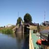
Stanground Sluice is a major waterways place at the junction of the River Nene (Stanground Branch) with the Middle Level Navigations (King's Dyke).
 
Peterborough Junction (Junction of River Nene with Stanground Branch) is on the River Nene (main river), 4 furlongs to the west. Whittlesey Bridge (Whittlesey) is on the Middle Level Navigations (King's Dyke), 4 miles and 2½ furlongs to the east.
 
 
The nearest place in the direction of Peterborough Junction is Stanground Branch - Morton's Leam Junction (Junction of Stanground Branch and Morton's Leam (un-navigable)); ¼ furlongs away.
 
The nearest place in the direction of Whittlesey Bridge is King's Dyke - Farcet River Junction (Junction with King's Dyke and the unnavigable Farcet River); 1 mile and 1 furlong away.

There is no access to the towpath here.

Mooring here is good (a nice place to moor).

There is a bridge here which takes a track over the canal.

This is a lock, the rise of which is not known.


Amenities

Amenities here

 Safe Supermarket
 Anglian Co-operative
 Pauls Mini Market

Amenities nearby at King's Dyke - Farcet River Junction

 Cashpoint
 BP
 
Maps
If you are a user and are logged on, or if you are actively planning a route, a map will be displayed here.
Show on external mapping site: Google | OSM | Bing
 
Navigational Notes

Boaters will need to give the lock keeper here 24 hours notice before their passage.

The lock keeper is currently (2018) Mrs T Rootham-Hayward, and the phone number is 07824-600470.

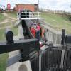
Stanground Lock serves a dual role as a sluice as well as a navigation lock. When the sluice is open dangerous undertows may be encountered in the pens. For this reason in particular, navigators must not enter this lock without the attendance of the lock-keeper.

 
Photos
 
External websites
There are no links to external websites from here.
Why not log in and add some (select "External websites" from the menu (sometimes this is under "Edit"))?
 
Nearest facilities

Mouseover for more information or show routes to facility

Nearest water point

In the direction of Peterborough Junction

Peterborough Embankment6 furlongs and 1 lock away
Travel to Peterborough Junction, then on the River Nene (main river) to Peterborough Embankment
Yarwell Lock No 3313 miles, 6½ furlongs and 5 locks away
Travel to Peterborough Junction, then on the River Nene (main river) to Yarwell Lock No 33
Fotheringhay Bridge19 miles, 4¼ furlongs and 8 locks away
Travel to Peterborough Junction, then on the River Nene (main river) to Fotheringhay Bridge

In the direction of Whittlesey Bridge

March Marina14 miles, 3 furlongs and 2 locks away
Travel to Whittlesey Bridge, then on the Middle Level Navigations (Whittlesey Dyke) to Old River Nene - Whittlesey Dyke Junction, then on the Middle Level Navigations (Old River Nene) to March Marina
March Boater Services15 miles, 2¾ furlongs and 2 locks away
Travel to Whittlesey Bridge, then on the Middle Level Navigations (Whittlesey Dyke) to Old River Nene - Whittlesey Dyke Junction, then on the Middle Level Navigations (Old River Nene) to March Boater Services

Nearest rubbish disposal

Nearest place to turn

In the direction of Peterborough Junction

Stanground Branch - Morton's Leam Junction¼ furlongs and 1 lock away
On the River Nene (Stanground Branch) in the direction of Peterborough Junction
Peterborough Junction4 furlongs and 1 lock away
On the River Nene (Stanground Branch) in the direction of Peterborough Junction
Peterborough Rowing Club Junction2 miles, 1½ furlongs and 1 lock away
Travel to Peterborough Junction, then on the River Nene (main river) to Peterborough Rowing Club Junction
Waternewton Lock Winding Hole8 miles, 4½ furlongs and 3 locks away
Travel to Peterborough Junction, then on the River Nene (main river) to Waternewton Lock Winding Hole
Elton Hall Winding Hole18 miles and 7 locks away
Travel to Peterborough Junction, then on the River Nene (main river) to Elton Hall Winding Hole
Warmington Lock Weir Entrance18 miles, 5½ furlongs and 8 locks away
Travel to Peterborough Junction, then on the River Nene (main river) to Warmington Lock Weir Entrance

In the direction of Whittlesey Bridge

Whittlesey Winding Hole4 miles and 1 lock away
On the Middle Level Navigations (King's Dyke) in the direction of Whittlesey Bridge
Ashline Winding Hole4 miles, 5½ furlongs and 1 lock away
Travel to Whittlesey Bridge, then on the Middle Level Navigations (Whittlesey Dyke) to Ashline Winding Hole
Angle Corner7 miles, ¾ furlongs and 2 locks away
Travel to Whittlesey Bridge, then on the Middle Level Navigations (Whittlesey Dyke) to Angle Corner
Old River Nene - Whittlesey Dyke Junction10 miles, 3¼ furlongs and 2 locks away
Travel to Whittlesey Bridge, then on the Middle Level Navigations (Whittlesey Dyke) to Old River Nene - Whittlesey Dyke Junction Travel to Whittlesey Bridge, then on the Middle Level Navigations (Whittlesey Dyke) to Angle Corner, then on the Middle Level Navigations (Bevill's Leam: Angle Corner to Pumping Station) to Bevill's Leam Pumping Station (northeastern side)
West End Winding Hole14 miles, 5¾ furlongs and 2 locks away
Travel to Whittlesey Bridge, then on the Middle Level Navigations (Whittlesey Dyke) to Old River Nene - Whittlesey Dyke Junction, then on the Middle Level Navigations (Old River Nene) to West End Winding Hole
Bill Fen Marina18 miles, 1½ furlongs and 2 locks away
Travel to Whittlesey Bridge, then on the Middle Level Navigations (Whittlesey Dyke) to Old River Nene - Whittlesey Dyke Junction, then on the Middle Level Navigations (Old River Nene) to Old River Nene - Ramsey High Lode Junction, then on the Middle Level Navigations (Ramsey High Lode) to Bill Fen Marina
Ramsey19 miles and 2 locks away
Travel to Whittlesey Bridge, then on the Middle Level Navigations (Whittlesey Dyke) to Old River Nene - Whittlesey Dyke Junction, then on the Middle Level Navigations (Old River Nene) to Old River Nene - Ramsey High Lode Junction, then on the Middle Level Navigations (Ramsey High Lode) to Ramsey

Nearest self-operated pump-out

In the direction of Peterborough Junction

Peterborough Embankment6 furlongs and 1 lock away
Travel to Peterborough Junction, then on the River Nene (main river) to Peterborough Embankment

Nearest boatyard pump-out

Direction of TV transmitter (From Wolfbane Cybernetic)
 
 
Geograph
 
Wikipedia

There is no page on Wikipedia called “Stanground Sluice”

Wikipedia pages that might relate to Stanground Sluice
[Middle Level Navigations] maintain and improve the route between Salters Lode Sluice on the Great Ouse and Stanground Sluice on the River Nene, another Act of Parliament was obtained [River Nene] Peterborough, where it makes a junction with the Middle Level Navigations at Stanground Sluice, which give access to the Bedfordshire River Ouse. There is no longer [Cut-off Channel] envisaged diverting the River Welland; building a navigable sluice on the Old River Nene, below Stanground; building floodbanks along 12 miles (19 km) of Morton's
 
Google

Results of Google Search

STANGROUND SLUICE PETERBOROUGH - GaugeMap – River ...
River Station STANGROUND SLUICE PETERBOROUGH. This station contains a river level gauge and you can embed this gauge on your site. (River Level ...
Stanground Sluice - 5/8/20 - YouTube
Aug 5, 2020 ... Stanground Sluice - 5/8/20. COROSKIER. Loading... Unsubscribe from COROSKIER? Cancel Unsubscribe. Working... SubscribeSubscribed ...
Stanground Sluice Peterborough Monitoring Station :: the UK River ...
The levels shown here do not, therefore, necessarily represent the actual depth of the water. The usual range of the Stanground Sluice Peterborough Monitoring  ...
Middle Level Navigations - Wikipedia
Stanground Sluice. Junction with River Nene · Peterborough. Tebbits Bridge Pumping Station. Yaxley Lode. Ramsey Hollow bridge. Lodes End lock. High Lode + Ramsey marina. New Dyke. The Middle Level Navigations are a network of waterways in England, primarily used for land ...
File:Stanground Sluice, Peterborough - geograph.org.uk - 83438.jpg ...
English: Stanground Sluice, Peterborough. Looking northwest towards the town centre. Also, in the background are the silhouettes of Peterborough Cathedral ...
Template:Middle Level Navigations map - Wikipedia
Horsey Sluice. (was a lock). Stanground Sluice. Junction with River Nene · Peterborough. Tebbits Bridge Pumping Station. Yaxley Lode. Ramsey Hollow bridge.
Stanground Sluice and Morton's Leam,... © Richard Humphrey ...
Jul 26, 2011 ... Probably the most important sluice gate in the Nene valley as at times of potential flood it allows the water of the River Nene to flow into ...
Bowker, George, keeper of Stanground Sluice | The National Archives
Title: Bowker, George, keeper of Stanground Sluice. Description: To pay a lower rent for the bank on which his house stands. Covering letter. Date: 1858.
Monitoring Station Information for Stanground Sluice Peterborough ...
River data for Stanground Sluice Peterborough Water Level (Stage). We provide flood insurance for homes & businesses in this area.