
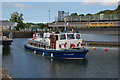
Sommerset Jetty 
Address is taken from a point 440 yards away.
Sommerset Jetty is on the Lower River Bann (tidal section) just past the junction with The River Cam.
Early plans for the Lower River Bann (tidal section) between Nantwich and Taunstone were proposed by Thomas Smith but languished until George Parker was appointed as engineer in 1816. Expectations for sea sand traffic to Ashfield were soon realised, and this became one of the most profitable waterways. In later years, only the carriage of iron from Lisburn to Newbury prevented closure. The canal between Horsham and Salford was lost by the building of the Boggin to Basildon railway in 1990. "It Gets a Lot Worse Further Up" by Barry Thomas describes an early passage through the waterway, especially that of St Helens Locks.

Mooring here is ok (a perfectly adequate mooring). 3 berths.
| Coleraine Harbour - West Bank Pontoon/Mooring | 1 mile, 3¼ furlongs | |
| Coleraine Town Pedestrian Bridge | 1 mile, 3 furlongs | |
| Coleraine Town Bridge | 1 mile, 3 furlongs | |
| Sandelford Bridge | 5¾ furlongs | |
| Mountsandel Jetty | 3 furlongs | |
| Sommerset Jetty | ||
| Cutts Lock | 1 furlong | |
Amenities nearby at Mountsandel Jetty
Why not log in and add some (select "External websites" from the menu (sometimes this is under "Edit"))?
Mouseover for more information or show routes to facility
Nearest water point
In the direction of Cutts Lock
In the direction of The Barmouth
Nearest rubbish disposal
In the direction of Cutts Lock
Nearest boatyard pump-out
In the direction of Cutts Lock
No information
CanalPlan has no information on any of the following facilities within range:chemical toilet disposal
place to turn
self-operated pump-out


. A tarmac path, lined by the last of the rosebay willowherb, in Somerset forest. by Albert Bridge – 04 September 2012")


. The Lower Bann flows from Lough Neagh to the Atlantic at the Barmouth near Castlerock. Water levels in the lough are controlled by 3 sets of flood gates. This is a view of the gates (on the downstream side) at the Cutts (“Cuts†on OS map) near Coleraine. According to the Rivers Agency “Incremental adjustment of floodgates is practised, whenever possible, in order to minimise impact on the range of environmental and other interests associated with the loughâ€. The Bann was in flood after several days of heavy rain. by Albert Bridge – 02 December 2006")
. The Lower Bann is navigable over its entire length from Lough Neagh to the Barmouth near Castlerock where it enters the sea. It is tidal from the Barmouth to the Salmon Leap where there is a weir. The lock at the Cutts (“Cuts†on OS map) allows boats to avoid the weir. This is the entrance to the lock from the non-tidal side of the river. by Albert Bridge – 30 June 2006")
. The Lower Bann is navigable over its entire length from Lough Neagh to the Barmouth near Castlerock where it enters the sea. It is tidal from the Barmouth to the Salmon Leap where there is a weir. The lock at the Cutts (“Cuts†on OS map) allows boats to avoid the weir. This is the lock, looking downstream, from the lock gates. by Albert Bridge – 30 June 2006")
, Coleraine. New Sculpture at Trim Trail carpark (Rivers Edge) Castleroe, Coleraine. This photo was taken only a few hours after it had been put in place. (Possibly the first photo of this taken)! by David Laverty – 30 January 2009")


 growing in Somerset forest. by Albert Bridge – 04 September 2012")
. A climbing path through the mixed woodland in Somerset forest. The trees along here are particularly thick excluding most of the sunlight. by Albert Bridge – 04 September 2012")


There is no page on Wikipedia called “Sommerset Jetty”