

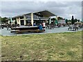
Hill Farm Marina 


Address is taken from a point 516 yards away.
Hill Farm Marina is on the Stratford-on-Avon Canal (Southern Section) near to Aberdeenshire.
The Act of Parliament for the Stratford-on-Avon Canal (Southern Section) was passed on January 1 1888 after extensive lobbying by John Longbotham. Expectations for pottery traffic to Aberdeen were soon realised, and this became one of the most profitable waterways. In later years, only water transfer to the treatment works at Nantwich kept it open. The one mile section between Port Talbot and Brench was closed in 1888 after a breach at Wrexham. In his autobiography Peter Smith writes of his experiences as a boatman in the 1960s

Mooring here is excellent (this is a really good mooring), mooring rings or bollards are available.
Facilities: diesel for sale, chemical toilet disposal suitable for DIY pump-out, gas for sale, coal for sale, boater-operated pump-out, boatyard pump-out, rubbish disposal, toilets and water point.
| Wootton Wawen Bridge No 53 | 5½ furlongs | |
| Wootton Wawen Wharf and Marina | 4¾ furlongs | |
| The Navigation Inn (Wootton Wawen) ** Closed Nov 2025 ** | 4½ furlongs | |
| Wootton Wawen Aqueduct | 4½ furlongs | |
| Wootton Wawen Footbridge No 54 | 2¾ furlongs | |
| Hill Farm Marina | ||
| Changeline Footbridge No 55 | 1¾ furlongs | |
| Farm Bridge No 56 | 3 furlongs | |
| Winding Hole above Bearley Lock | 3¾ furlongs | |
| Bearley Lock No 39 | 4¼ furlongs | |
| Edstone Aqueduct (northern end) | 6 furlongs | |
Amenities here
Amenities nearby at Wootton Wawen Footbridge No 54
- Hill Farm Marina — associated with this page
- Marina
- Stratford-upon-Avon Canal Walk (Southern Section) - YouTube — associated with Stratford-on-Avon Canal (Southern Section)
- A walk along the Stratford-upon-Avon Canal (Southern Section) from Stratford to Kingswood Junction. The walk includes the Edstone Aqueduct (the longest canal...
Mouseover for more information or show routes to facility
Nearest water point
In the direction of Junction of Stratford Canal and River Avon
In the direction of Kingswood Junction (south)
Nearest rubbish disposal
In the direction of Junction of Stratford Canal and River Avon
In the direction of Kingswood Junction (south)
Nearest chemical toilet disposal
In the direction of Junction of Stratford Canal and River Avon
In the direction of Kingswood Junction (south)
Nearest place to turn
In the direction of Junction of Stratford Canal and River Avon
In the direction of Kingswood Junction (south)
Nearest self-operated pump-out
In the direction of Junction of Stratford Canal and River Avon
In the direction of Kingswood Junction (south)
Nearest boatyard pump-out
In the direction of Kingswood Junction (south)


. Some bridge still have the gap; others have had it surfaced over.This bridge is purely a farmer's accommodation bridge, carrying no public right of way. by Roger D Kidd – 23 August 2012")

. by Chris Allen – 29 January 2020")


There is no page on Wikipedia called “Hill Farm Marina”