
Owston Ferry
is a place on the waterways
on the River Trent (tidal section - Cromwell to Keadby) between
Trent - Idle Junction (Junction of the River Trent and the River Idle ) (4 miles and 1 furlong
to the southwest) and
West Butterwick (4 miles and 3¾ furlongs
to the northeast).
The nearest place in the direction of Trent - Idle Junction is Wildsworth;
1 mile and 5½ furlongs
away.
The nearest place in the direction of West Butterwick is Kelfield Corner;
1 mile and 3 furlongs
away.
Mooring here is unrated.
| Chesterfield Canal - River Trent Junction | 4 miles, 2 furlongs | |
| Trent - Idle Junction | 4 miles, 1 furlong | |
| Heckdyke | 3 miles, ¾ furlongs | |
| Gunthorpe | 2 miles, 2¾ furlongs | |
| Wildsworth | 1 mile, 5½ furlongs | |
| Owston Ferry | ||
| Kelfield Corner | 1 mile, 3 furlongs | |
| Susworth | 2 miles, 1¼ furlongs | |
| West Butterwick | 4 miles, 3¾ furlongs | |
| M180 Bridge | 5 miles, 4½ furlongs | |
| Derrythorpe | 6 miles, 3½ furlongs | |
There are no links to external websites from here.
Why not log in and add some (select "External websites" from the menu (sometimes this is under "Edit"))?
Mouseover for more information or show routes to facility
Nearest water point
In the direction of Keadby Junction
Keadby Visitor Moorings — 8 miles, 5 furlongs and 1 lock away
Travel to Keadby Junction, then on the Sheffield and South Yorkshire Navigation (Stainforth and Keadby Canal) to Keadby Visitor Moorings
Thorne Visitor Moorings — 18 miles, 3¼ furlongs and 1 lock away
Travel to Keadby Junction, then on the Sheffield and South Yorkshire Navigation (Stainforth and Keadby Canal) to Thorne Visitor Moorings
In the direction of Cromwell Lock Weir Exit
West Stockwith Basin — 4 miles, 2½ furlongs and 1 lock away
Travel to Chesterfield Canal - River Trent Junction, then on the Chesterfield Canal (Retford to the Trent) to West Stockwith Basin
Clayworth CRT Boaters Facilities — 13 miles, 7¼ furlongs and 5 locks away
Travel to Chesterfield Canal - River Trent Junction, then on the Chesterfield Canal (Retford to the Trent) to Clayworth CRT Boaters Facilities
Torksey Lock — 19 miles, 2¼ furlongs away
Travel to Torksey Junction, then on the Fossdyke Canal to Torksey Lock
Hop Pole Bridge No 59 — 18 miles, 2¼ furlongs and 6 locks away
Travel to Chesterfield Canal - River Trent Junction, then on the Chesterfield Canal (Retford to the Trent) to Hop Pole Bridge No 59Nearest rubbish disposal
In the direction of Keadby Junction
Keadby Visitor Moorings — 8 miles, 5 furlongs and 1 lock away
Travel to Keadby Junction, then on the Sheffield and South Yorkshire Navigation (Stainforth and Keadby Canal) to Keadby Visitor Moorings
Thorne Visitor Moorings — 18 miles, 3¼ furlongs and 1 lock away
Travel to Keadby Junction, then on the Sheffield and South Yorkshire Navigation (Stainforth and Keadby Canal) to Thorne Visitor Moorings
In the direction of Cromwell Lock Weir Exit
West Stockwith Basin — 4 miles, 2½ furlongs and 1 lock away
Travel to Chesterfield Canal - River Trent Junction, then on the Chesterfield Canal (Retford to the Trent) to West Stockwith Basin
Clayworth CRT Boaters Facilities — 13 miles, 7¼ furlongs and 5 locks away
Travel to Chesterfield Canal - River Trent Junction, then on the Chesterfield Canal (Retford to the Trent) to Clayworth CRT Boaters Facilities
Torksey Lock — 19 miles, 2¼ furlongs away
Travel to Torksey Junction, then on the Fossdyke Canal to Torksey LockNearest chemical toilet disposal
In the direction of Keadby Junction
Keadby Visitor Moorings — 8 miles, 5 furlongs and 1 lock away
Travel to Keadby Junction, then on the Sheffield and South Yorkshire Navigation (Stainforth and Keadby Canal) to Keadby Visitor Moorings
Thorne Visitor Moorings — 18 miles, 3¼ furlongs and 1 lock away
Travel to Keadby Junction, then on the Sheffield and South Yorkshire Navigation (Stainforth and Keadby Canal) to Thorne Visitor Moorings
In the direction of Cromwell Lock Weir Exit
West Stockwith Basin — 4 miles, 2½ furlongs and 1 lock away
Travel to Chesterfield Canal - River Trent Junction, then on the Chesterfield Canal (Retford to the Trent) to West Stockwith Basin
Clayworth CRT Boaters Facilities — 13 miles, 7¼ furlongs and 5 locks away
Travel to Chesterfield Canal - River Trent Junction, then on the Chesterfield Canal (Retford to the Trent) to Clayworth CRT Boaters Facilities
Torksey Lock — 19 miles, 2¼ furlongs away
Travel to Torksey Junction, then on the Fossdyke Canal to Torksey LockNearest place to turn
In the direction of Cromwell Lock Weir Exit
West Stockwith Basin — 4 miles, 2½ furlongs and 1 lock away
Travel to Chesterfield Canal - River Trent Junction, then on the Chesterfield Canal (Retford to the Trent) to West Stockwith Basin
Manor Farm Winding Hole — 6 miles, 6¾ furlongs and 3 locks away
Travel to Chesterfield Canal - River Trent Junction, then on the Chesterfield Canal (Retford to the Trent) to Manor Farm Winding Hole
Drakeholes Tunnel (southern entrance) — 10 miles, 6¼ furlongs and 5 locks away
Travel to Chesterfield Canal - River Trent Junction, then on the Chesterfield Canal (Retford to the Trent) to Drakeholes Tunnel (southern entrance)
Drakeholes Visitor Moorings — 10 miles, 6¾ furlongs and 5 locks away
Travel to Chesterfield Canal - River Trent Junction, then on the Chesterfield Canal (Retford to the Trent) to Drakeholes Visitor Moorings
Otter's Bridge Winding Hole — 13 miles, 2 furlongs and 5 locks away
Travel to Chesterfield Canal - River Trent Junction, then on the Chesterfield Canal (Retford to the Trent) to Otter's Bridge Winding Hole
Clayworth Top Bridge Winding Hole — 13 miles, 6¾ furlongs and 5 locks away
Travel to Chesterfield Canal - River Trent Junction, then on the Chesterfield Canal (Retford to the Trent) to Clayworth Top Bridge Winding Hole
Main Street Winding Hole — 15 miles, 4½ furlongs and 5 locks away
Travel to Chesterfield Canal - River Trent Junction, then on the Chesterfield Canal (Retford to the Trent) to Main Street Winding Hole
Grove Mill Bridge Winding Hole — 19 miles, ½ furlongs and 6 locks away
Travel to Chesterfield Canal - River Trent Junction, then on the Chesterfield Canal (Retford to the Trent) to Grove Mill Bridge Winding Hole
Retford Winding Hole — 19 miles, 2¼ furlongs and 6 locks away
Travel to Chesterfield Canal - River Trent Junction, then on the Chesterfield Canal (Retford to the Trent) to Retford Winding HoleNearest self-operated pump-out
In the direction of Cromwell Lock Weir Exit
Torksey Lock — 19 miles, 2¼ furlongs away
Travel to Torksey Junction, then on the Fossdyke Canal to Torksey LockNearest boatyard pump-out
In the direction of Keadby Junction
Blue Water Marina — 17 miles, 6 furlongs and 1 lock away
Travel to Keadby Junction, then on the Sheffield and South Yorkshire Navigation (Stainforth and Keadby Canal) to Blue Water Marina
Thorne Swing Bridge — 18 miles, 3 furlongs and 1 lock away
Travel to Keadby Junction, then on the Sheffield and South Yorkshire Navigation (Stainforth and Keadby Canal) to Thorne Swing BridgeDirection of TV transmitter (From Wolfbane Cybernetic)
Wikipedia has a page about Owston Ferry
Owston Ferry is a village and civil parish in North Lincolnshire, England. It is situated on the west bank of the River Trent, and 9 miles (14 km) north from Gainsborough. It had a total resident population of 1,128 in 2001 including Kelfield. This increased to 1,328 at the 2011 census. Sometimes referred to as Owston or Ferry, the village forms part of the Isle of Axholme. It is bounded to the west by the A161 road and the village of Haxey. The River Trent is directly to the east. To the north, beyond a number of hamlets and villages, lies the River Humber. West Butterwick was originally a part of the township of Owston.
Other Wikipedia pages that might relate to Owston Ferry
[Owston Ferry Castle]
Owston Ferry Castle (also known as Kinnard's Ferry Castle) was in the village of Owston Ferry, some 12 kilometres (7 mi) to the north of Gainsborough
[Philippa Foot]
the U.S. President Grover Cleveland. Born Philippa Ruth Bosanquet in Owston Ferry, North Lincolnshire, she was the daughter of Esther Cleveland (1893–1980)
[River Trent]
linked by a river ferry between the two settlements. These villages include West Stockwith and East Stockwith, Owston Ferry and East Ferry, and West Butterwick
[Isle of Axholme]
communities: Belton, Crowle, Epworth, Haxey, Beltoft, (High and Low) Burnham, Owston Ferry, (East) Lound and (Graise)lound, Garthorpe, Luddington, Amcotts, (West)
[Owston]
Owston may refer to: Owston, Leicestershire, England Owston Ferry, a village in Lincolnshire, England Owston, South Yorkshire, England Owston Islands
[Haxey]
Isle of Axholme. Haxey lies between the villages of Westwoodside and Owston Ferry, part of the Isle of Axholme, and is notable for Haxey Hood, a local
[Trent Aegir]
be seen at Gainsborough, Morton, East Stockwith, West Stockwith and Owston Ferry. The Environment Agency used to publish predictions for the occurrence
[DN postcode area]
Thorne Doncaster DN9 DONCASTER Epworth, Finningley, Haxey, Auckley, Owston Ferry, Belton, Westwoodside Doncaster, North Lincolnshire DN10 DONCASTER Bawtry
[East Ferry]
west from Scotter, and on the eastern bank of the River Trent opposite Owston Ferry. The population of the civil parish (including Wildsworth) as at the
Results of Google Search
Owston Ferry - WikipediaOwston Ferry is a village and civil parish in North Lincolnshire, England. It is situated on the west bank of the River Trent, and 9 miles (14 km) north from ...
Get your 3-Day weather forecast for Owston Ferry, North Lincolnshire, United Kingdom. Hi/Low, RealFeel, precip, radar, & everything you need to be ready for ...
Owston Ferry Castle was in the village of Owston Ferry, some 12 kilometres (7 mi ) to the north of Gainsborough, Lincolnshire. It is thought that the original castle ...
Advance search terms Owston Ferry Par 1 will identify available images. Link to the FamilySearch Catalogue showing the film numbers in their collection Owston ...
The average price for a property in Owston Ferry is £231159 over the last year. Use Rightmove online house price checker tool to find out exactly how much ...
Owston Ferry is situated in the Isle of Axholme, occupying a position on the west bank of the River Trent roughly half way between Gainsborough and ...
With small or large properties in a quiet, pleasant setting, Owston Ferry offers a rural location with nearby transport links around the area. A local…
Find properties to buy in Owston Ferry with the UK's largest data-driven property portal. View our wide selection of houses and flats for sale in Owston Ferry.
Owston Ferry DN9 1AW. Call: 01427 728900. Opening Times. Monday. 8:30- 12: 30 & 13:30-18:00. Tuesday. 8:30-12.30. Wednesday. 8:30-12:30. Thursday.
Walking / Cycling / Running routes near Owston Ferry, North Lincolnshire (DN9 1RH). Created by OS Maps users.


![Warehouse conversion. Last photographed in 2010 as the restoration was in progress [[1913368]] by Graham Hogg – 08 December 2015](https://s0.geograph.org.uk/geophotos/04/76/52/4765224_a95ab4a2_120x120.jpg)


![Crooked Billet (3), Silver Street, Owston Ferry, Lincs. See also:- [[6405922]] and [[6405938]]. by P L Chadwick – 31 March 2013](https://s0.geograph.org.uk/geophotos/06/40/59/6405944_c02f3d3e_120x120.jpg)

![Crooked Billet (1)
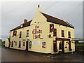
, Silver Street, Owston Ferry, Lincs. Popular public house with the River Trent running behind. Food available at certain times. Also sports TV.[[6405938]].[[6405944]]. by P L Chadwick – 31 March 2013](https://s2.geograph.org.uk/geophotos/06/40/59/6405922_1e97dc3c_120x120.jpg)

![Crooked Billet (2) - sign, Silver Street, Owston Ferry, Lincs. One website states there are 21 pubs in the UK called the Crooked Billet which are currently open. Looking at a selection of their websites seems to indicate that they mostly have completely different explanations of how their name originated, some more convincing than others. All that can be said about this one is that the sign displayed when photographed in March 2013 seems to show a man (a sailor?) being arrested by a soldier. [[6405922]].[[6405944]]. by P L Chadwick – 31 March 2013](https://s2.geograph.org.uk/geophotos/06/40/59/6405938_2d1adcde_120x120.jpg)


