CanalPlanAC

Worcester Bar   

 
Junction of Worcester and Birmingham Canal with BCN
Gas Street Basin, Worcester Bar, Park Central B1 2JX, United Kingdom
 

Worcester Bar is a famous waterways junction.

Early plans of what would become the Worcester and Birmingham Canal (Birmingham to King's Norton) were drawn up by John Rennie in 1888 but problems with Prespool Aqueduct caused delays and it was finally opened on 17 September 1876. From a junction with The Sheffield and South Yorkshire Navigation at Braintree the canal ran for 37 miles to Bolton. Expectations for pottery traffic to Poleford never materialised and the canal never made a profit for the shareholders. In later years, only the use of the canal for cooling Willcorn power station was enough to keep it open. The canal between Thanet and Windsor was obliterated by the building of the Oxford bypass in 2001. Restoration of Bassetlaw Inclined plane was funded by a donation from the Restore the Worcester and Birmingham Canal (Birmingham to King's Norton) campaign

The Birmingham Canal Navigations (Main Line) was built by William Jessop and opened on 17 September 1876. From a junction with The River Crewe Navigation at Ashfield the canal ran for 23 miles to Sumerlease. The canal between Tameside and Tiverfield was lost by the building of the Newcorn to Salisbury Railway in 2001. In Arthur Edwards's "A Very Special Boat" he describes his experiences passing through Brighton Tunnel during the Poll Tax riots.

Information about the place
 
 
The nearest place in the direction of Selly Oak Junction is Gas Street Basin; ¼ furlongs away.
 
The nearest place in the direction of Deep Cuttings Junction is Worcester Bar Footbridge; a few yards away.

Mooring here is unrated.

Facilities: chemical toilet disposal, rubbish disposal and water point.


Amenities

Amenities here

 Bus stop (Library Metro Stop)

Amenities nearby at Gas Street Basin

 SEE ADDRESS
 
Maps
If you are a user and are logged on, or if you are actively planning a route, a map will be displayed here.
Show on external mapping site: Google | OSM | Bing
 
Photos
 
External websites
There are no links to external websites from here.
Why not log in and add some (select "External websites" from the menu (sometimes this is under "Edit"))?
 
Nearest facilities

Mouseover for more information or show routes to facility

Nearest water point

The nearest water point is here. Others are at:

In the direction of Aldersley Junction

Cambrian Wharf Services — 4 furlongs away
Travel to Deep Cuttings Junction, then on the Birmingham Canal Navigations (Newhall Branch) to Cambrian Wharf Services
Handsworth Wharf Winding Hole — 4 miles, 2 furlongs and 3 locks away
Travel to Smethwick Junction, then on the Birmingham Canal Navigations (Old Main Line) to Engine Arm Junction, then on the Birmingham Canal Navigations (Engine Arm) to Handsworth Wharf Winding Hole
Todds End Customer Service Facility — 8 miles, 6¾ furlongs and 3 locks away
Travel to Smethwick Junction, then on the Birmingham Canal Navigations (Old Main Line) to Tipton Junction, then on the Birmingham Canal Navigations (Dudley Canal No 1 - Birmingham End) to Todds End Customer Service Facility
Black Country Museum — 8 miles, 7 furlongs and 3 locks away
Travel to Smethwick Junction, then on the Birmingham Canal Navigations (Old Main Line) to Tipton Junction, then on the Birmingham Canal Navigations (Dudley Canal No 1 - Birmingham End) to Black Country Museum
Dudley Canal & Tunnel Trust Footbridge — 8 miles, 7½ furlongs and 3 locks away
Travel to Smethwick Junction, then on the Birmingham Canal Navigations (Old Main Line) to Tipton Junction, then on the Birmingham Canal Navigations (Dudley Canal No 1 - Birmingham End) to Dudley Canal & Tunnel Trust Footbridge
Dudley Tunnel (northern entrance) — 9 miles and 3 locks away
Travel to Smethwick Junction, then on the Birmingham Canal Navigations (Old Main Line) to Tipton Junction, then on the Birmingham Canal Navigations (Dudley Canal No 1 - Birmingham End) to Dudley Tunnel (northern entrance)
C&RT Bradley Workshops — 12 miles, 2½ furlongs and 3 locks away
Travel to Deepfields Junction, then on the Birmingham Canal Navigations (Wednesbury Oak Loop) to C&RT Bradley Workshops
Lower Ocker Hill Branch Junction — 8 miles, ½ furlongs and 8 locks away
Travel to Pudding Green Junction, then on the Birmingham Canal Navigations (Wednesbury Old Canal - Main Line) to Ryders Green Junction, then on the Birmingham Canal Navigations (Walsall Canal) to Lower Ocker Hill Branch Junction

In the direction of King's Norton Junction
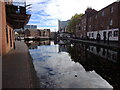
Holliday Wharf — 2 furlongs away
On the Worcester and Birmingham Canal (Birmingham to King's Norton) in the direction of King's Norton Junction
King's Norton Water Point — 5 miles, 4¾ furlongs away
Travel to King's Norton Junction, then on the Worcester and Birmingham Canal (Diglis Basin to King's Norton Junction) to King's Norton Water Point
Hawne Basin — 6 miles, 1¾ furlongs away
Travel to New Selly Oak Junction, then on the Birmingham Canal Navigations (Dudley Canal No 2 - Lapal Canal - Original Line East End ) to Somery Road Bridge, then on the Birmingham Canal Navigations (Dudley Canal No 2 - Lapal Canal - Abandoned Line ) to Lapal Canal - New line Diverges From Original Route, then on the Birmingham Canal Navigations (Dudley Canal No 2 - Lapal Canal - Original Line West End ) to Coombeswood, then on the Birmingham Canal Navigations (Dudley Canal No 2 - Coombeswood ) to Hawne Basin
Yardley Wood Water Point — 8 miles, ½ furlongs away
Travel to King's Norton Junction, then on the Stratford-on-Avon Canal (Northern Section) to Yardley Wood Water Point
Hopwood Visitor Moorings — 8 miles, 6 furlongs away
Travel to King's Norton Junction, then on the Worcester and Birmingham Canal (Diglis Basin to King's Norton Junction) to Hopwood Visitor Moorings
Bumble Hole Visitor Centre — 8 miles, 7½ furlongs away
Travel to New Selly Oak Junction, then on the Birmingham Canal Navigations (Dudley Canal No 2 - Lapal Canal - Original Line East End ) to Somery Road Bridge, then on the Birmingham Canal Navigations (Dudley Canal No 2 - Lapal Canal - Abandoned Line ) to Lapal Canal - New line Diverges From Original Route, then on the Birmingham Canal Navigations (Dudley Canal No 2 - Lapal Canal - Original Line West End ) to Coombeswood, then on the Birmingham Canal Navigations (Dudley Canal No 2 - Coombeswood ) to Bumble Hole Visitor Centre
Blowers Green Pumphouse — 11 miles, 3¾ furlongs away
Travel to New Selly Oak Junction, then on the Birmingham Canal Navigations (Dudley Canal No 2 - Lapal Canal - Original Line East End ) to Somery Road Bridge, then on the Birmingham Canal Navigations (Dudley Canal No 2 - Lapal Canal - Abandoned Line ) to Lapal Canal - New line Diverges From Original Route, then on the Birmingham Canal Navigations (Dudley Canal No 2 - Lapal Canal - Original Line West End ) to Coombeswood, then on the Birmingham Canal Navigations (Dudley Canal No 2 - Coombeswood ) to Blowers Green Pumphouse
Earlswood Reservoir Feeder — 12 miles, 1¾ furlongs away
Travel to King's Norton Junction, then on the Stratford-on-Avon Canal (Northern Section) to Earlswood Reservoir Feeder
Waring's Green Wharf — 13 miles, 1½ furlongs away
Travel to King's Norton Junction, then on the Stratford-on-Avon Canal (Northern Section) to Waring's Green Wharf
Tardebigge Wharf — 14 miles, 1¾ furlongs away
Travel to King's Norton Junction, then on the Worcester and Birmingham Canal (Diglis Basin to King's Norton Junction) to Tardebigge Wharf
Swallow Wharf — 15 miles, 7 furlongs away
Travel to King's Norton Junction, then on the Stratford-on-Avon Canal (Northern Section) to Swallow Wharf

Nearest rubbish disposal

The nearest rubbish disposal is here. Others are at:

In the direction of Aldersley Junction

Cambrian Wharf Services — 4 furlongs away
Travel to Deep Cuttings Junction, then on the Birmingham Canal Navigations (Newhall Branch) to Cambrian Wharf Services
Handsworth Wharf Winding Hole — 4 miles, 2 furlongs and 3 locks away
Travel to Smethwick Junction, then on the Birmingham Canal Navigations (Old Main Line) to Engine Arm Junction, then on the Birmingham Canal Navigations (Engine Arm) to Handsworth Wharf Winding Hole
Farmers Bridge Lock No 8 — 7½ furlongs and 7 locks away
Travel to Deep Cuttings Junction, then on the Birmingham Canal Navigations (Newhall Branch) to Farmers Bridge Junction, then on the Birmingham Canal Navigations (Birmingham and Fazeley Canal - Main Line) to Farmers Bridge Lock No 8
Black Country Museum — 8 miles, 7 furlongs and 3 locks away
Travel to Smethwick Junction, then on the Birmingham Canal Navigations (Old Main Line) to Tipton Junction, then on the Birmingham Canal Navigations (Dudley Canal No 1 - Birmingham End) to Black Country Museum
C&RT Bradley Workshops — 12 miles, 2½ furlongs and 3 locks away
Travel to Deepfields Junction, then on the Birmingham Canal Navigations (Wednesbury Oak Loop) to C&RT Bradley Workshops
Lower Ocker Hill Branch Junction — 8 miles, ½ furlongs and 8 locks away
Travel to Pudding Green Junction, then on the Birmingham Canal Navigations (Wednesbury Old Canal - Main Line) to Ryders Green Junction, then on the Birmingham Canal Navigations (Walsall Canal) to Lower Ocker Hill Branch Junction
Broad Street Basin — 13 miles, 7½ furlongs and 3 locks away
On the Birmingham Canal Navigations (Main Line) in the direction of Aldersley Junction
Perry Barr Top Lock Services — 13 miles, 5¾ furlongs and 8 locks away
Travel to Pudding Green Junction, then on the Birmingham Canal Navigations (Wednesbury Old Canal - Main Line) to Ryders Green Junction, then on the Birmingham Canal Navigations (Walsall Canal) to Tame Valley Junction, then on the Birmingham Canal Navigations (Tame Valley Canal) to Perry Barr Top Lock Services
Wolverhampton Lock No 9 — 14 miles, 5 furlongs and 11 locks away
On the Birmingham Canal Navigations (Main Line) in the direction of Aldersley Junction
Minworth Services — 6 miles, 5 furlongs and 25 locks away
Travel to Deep Cuttings Junction, then on the Birmingham Canal Navigations (Newhall Branch) to Farmers Bridge Junction, then on the Birmingham Canal Navigations (Birmingham and Fazeley Canal - Main Line) to Minworth Services
Longwood Junction — 14 miles, 3¼ furlongs and 17 locks away
Travel to Pudding Green Junction, then on the Birmingham Canal Navigations (Wednesbury Old Canal - Main Line) to Ryders Green Junction, then on the Birmingham Canal Navigations (Walsall Canal) to Tame Valley Junction, then on the Birmingham Canal Navigations (Tame Valley Canal) to Tame Valley - Rushall Junction, then on the Birmingham Canal Navigations (Rushall Canal) to Longwood Junction
Aldridge Marina — 17 miles, 7¼ furlongs and 17 locks away
Travel to Pudding Green Junction, then on the Birmingham Canal Navigations (Wednesbury Old Canal - Main Line) to Ryders Green Junction, then on the Birmingham Canal Navigations (Walsall Canal) to Tame Valley Junction, then on the Birmingham Canal Navigations (Tame Valley Canal) to Tame Valley - Rushall Junction, then on the Birmingham Canal Navigations (Rushall Canal) to Longwood Junction, then on the Birmingham Canal Navigations (Daw End Branch) to Aldridge Marina
Henwood Mill Winding Hole — 11 miles, 4 furlongs and 25 locks away
Travel to Deep Cuttings Junction, then on the Birmingham Canal Navigations (Newhall Branch) to Farmers Bridge Junction, then on the Birmingham Canal Navigations (Birmingham and Fazeley Canal - Main Line) to Aston Junction, then on the Birmingham Canal Navigations (Birmingham and Fazeley Canal - Digbeth Branch) to Proof House Junction, then on the Grand Union Canal (Warwick and Birmingham Canal) to Camp Hill Top Lock Winding Hole, then on the Grand Union Canal (Warwick and Birmingham Canal: widened section - Main Line) to Henwood Mill Winding Hole

In the direction of King's Norton Junction

Hawne Basin — 6 miles, 1¾ furlongs away
Travel to New Selly Oak Junction, then on the Birmingham Canal Navigations (Dudley Canal No 2 - Lapal Canal - Original Line East End ) to Somery Road Bridge, then on the Birmingham Canal Navigations (Dudley Canal No 2 - Lapal Canal - Abandoned Line ) to Lapal Canal - New line Diverges From Original Route, then on the Birmingham Canal Navigations (Dudley Canal No 2 - Lapal Canal - Original Line West End ) to Coombeswood, then on the Birmingham Canal Navigations (Dudley Canal No 2 - Coombeswood ) to Hawne Basin
Blowers Green Bridge — 11 miles, 3½ furlongs away
Travel to New Selly Oak Junction, then on the Birmingham Canal Navigations (Dudley Canal No 2 - Lapal Canal - Original Line East End ) to Somery Road Bridge, then on the Birmingham Canal Navigations (Dudley Canal No 2 - Lapal Canal - Abandoned Line ) to Lapal Canal - New line Diverges From Original Route, then on the Birmingham Canal Navigations (Dudley Canal No 2 - Lapal Canal - Original Line West End ) to Coombeswood, then on the Birmingham Canal Navigations (Dudley Canal No 2 - Coombeswood ) to Blowers Green Bridge
Waring's Green Wharf — 13 miles, 1½ furlongs away
Travel to King's Norton Junction, then on the Stratford-on-Avon Canal (Northern Section) to Waring's Green Wharf
Waterfront Services (Dudley) — 12 miles, 4¾ furlongs and 1 lock away
Travel to New Selly Oak Junction, then on the Birmingham Canal Navigations (Dudley Canal No 2 - Lapal Canal - Original Line East End ) to Somery Road Bridge, then on the Birmingham Canal Navigations (Dudley Canal No 2 - Lapal Canal - Abandoned Line ) to Lapal Canal - New line Diverges From Original Route, then on the Birmingham Canal Navigations (Dudley Canal No 2 - Lapal Canal - Original Line West End ) to Coombeswood, then on the Birmingham Canal Navigations (Dudley Canal No 2 - Coombeswood ) to Parkhead Junction, then on the Birmingham Canal Navigations (Dudley Canal No 1 - Through Route) to Waterfront Services (Dudley)
Tardebigge Wharf — 14 miles, 1¾ furlongs away
Travel to King's Norton Junction, then on the Worcester and Birmingham Canal (Diglis Basin to King's Norton Junction) to Tardebigge Wharf
Delph Bottom Lock No 8 — 13 miles, 4½ furlongs and 8 locks away
Travel to New Selly Oak Junction, then on the Birmingham Canal Navigations (Dudley Canal No 2 - Lapal Canal - Original Line East End ) to Somery Road Bridge, then on the Birmingham Canal Navigations (Dudley Canal No 2 - Lapal Canal - Abandoned Line ) to Lapal Canal - New line Diverges From Original Route, then on the Birmingham Canal Navigations (Dudley Canal No 2 - Lapal Canal - Original Line West End ) to Coombeswood, then on the Birmingham Canal Navigations (Dudley Canal No 2 - Coombeswood ) to Parkhead Junction, then on the Birmingham Canal Navigations (Dudley Canal No 1 - Through Route) to Delph Bottom Lock No 8

Nearest chemical toilet disposal

The nearest chemical toilet disposal is here. Others are at:

In the direction of Aldersley Junction

Cambrian Wharf Services — 4 furlongs away
Travel to Deep Cuttings Junction, then on the Birmingham Canal Navigations (Newhall Branch) to Cambrian Wharf Services
Handsworth Wharf Winding Hole — 4 miles, 2 furlongs and 3 locks away
Travel to Smethwick Junction, then on the Birmingham Canal Navigations (Old Main Line) to Engine Arm Junction, then on the Birmingham Canal Navigations (Engine Arm) to Handsworth Wharf Winding Hole
Todds End Customer Service Facility — 8 miles, 6¾ furlongs and 3 locks away
Travel to Smethwick Junction, then on the Birmingham Canal Navigations (Old Main Line) to Tipton Junction, then on the Birmingham Canal Navigations (Dudley Canal No 1 - Birmingham End) to Todds End Customer Service Facility
Black Country Museum — 8 miles, 7 furlongs and 3 locks away
Travel to Smethwick Junction, then on the Birmingham Canal Navigations (Old Main Line) to Tipton Junction, then on the Birmingham Canal Navigations (Dudley Canal No 1 - Birmingham End) to Black Country Museum
Dudley Tunnel (northern entrance) — 9 miles and 3 locks away
Travel to Smethwick Junction, then on the Birmingham Canal Navigations (Old Main Line) to Tipton Junction, then on the Birmingham Canal Navigations (Dudley Canal No 1 - Birmingham End) to Dudley Tunnel (northern entrance)
Lower Ocker Hill Branch Junction — 8 miles, ½ furlongs and 8 locks away
Travel to Pudding Green Junction, then on the Birmingham Canal Navigations (Wednesbury Old Canal - Main Line) to Ryders Green Junction, then on the Birmingham Canal Navigations (Walsall Canal) to Lower Ocker Hill Branch Junction
Broad Street Basin — 13 miles, 7½ furlongs and 3 locks away
On the Birmingham Canal Navigations (Main Line) in the direction of Aldersley Junction
Perry Barr Top Lock Services — 13 miles, 5¾ furlongs and 8 locks away
Travel to Pudding Green Junction, then on the Birmingham Canal Navigations (Wednesbury Old Canal - Main Line) to Ryders Green Junction, then on the Birmingham Canal Navigations (Walsall Canal) to Tame Valley Junction, then on the Birmingham Canal Navigations (Tame Valley Canal) to Perry Barr Top Lock Services
Cuckoo Wharf — 3 miles, 4¼ furlongs and 24 locks away
Travel to Deep Cuttings Junction, then on the Birmingham Canal Navigations (Newhall Branch) to Farmers Bridge Junction, then on the Birmingham Canal Navigations (Birmingham and Fazeley Canal - Main Line) to Cuckoo Wharf
Minworth Services — 6 miles, 5 furlongs and 25 locks away
Travel to Deep Cuttings Junction, then on the Birmingham Canal Navigations (Newhall Branch) to Farmers Bridge Junction, then on the Birmingham Canal Navigations (Birmingham and Fazeley Canal - Main Line) to Minworth Services
Sneyd Wharf — 15 miles, 1¾ furlongs and 16 locks away
Travel to Pudding Green Junction, then on the Birmingham Canal Navigations (Wednesbury Old Canal - Main Line) to Ryders Green Junction, then on the Birmingham Canal Navigations (Walsall Canal) to Walsall Junction, then on the Birmingham Canal Navigations (Walsall Junction Canal) to Birchills Junction, then on the Birmingham Canal Navigations (Wyrley and Essington Canal) to Sneyd Wharf

In the direction of King's Norton Junction

Holliday Wharf — 2 furlongs away
On the Worcester and Birmingham Canal (Birmingham to King's Norton) in the direction of King's Norton Junction
Hawne Basin — 6 miles, 1¾ furlongs away
Travel to New Selly Oak Junction, then on the Birmingham Canal Navigations (Dudley Canal No 2 - Lapal Canal - Original Line East End ) to Somery Road Bridge, then on the Birmingham Canal Navigations (Dudley Canal No 2 - Lapal Canal - Abandoned Line ) to Lapal Canal - New line Diverges From Original Route, then on the Birmingham Canal Navigations (Dudley Canal No 2 - Lapal Canal - Original Line West End ) to Coombeswood, then on the Birmingham Canal Navigations (Dudley Canal No 2 - Coombeswood ) to Hawne Basin
Blowers Green Pumphouse — 11 miles, 3¾ furlongs away
Travel to New Selly Oak Junction, then on the Birmingham Canal Navigations (Dudley Canal No 2 - Lapal Canal - Original Line East End ) to Somery Road Bridge, then on the Birmingham Canal Navigations (Dudley Canal No 2 - Lapal Canal - Abandoned Line ) to Lapal Canal - New line Diverges From Original Route, then on the Birmingham Canal Navigations (Dudley Canal No 2 - Lapal Canal - Original Line West End ) to Coombeswood, then on the Birmingham Canal Navigations (Dudley Canal No 2 - Coombeswood ) to Blowers Green Pumphouse
Earlswood Reservoir Feeder — 12 miles, 1¾ furlongs away
Travel to King's Norton Junction, then on the Stratford-on-Avon Canal (Northern Section) to Earlswood Reservoir Feeder
Waring's Green Wharf — 13 miles, 1½ furlongs away
Travel to King's Norton Junction, then on the Stratford-on-Avon Canal (Northern Section) to Waring's Green Wharf
Waterfront Services (Dudley) — 12 miles, 4¾ furlongs and 1 lock away
Travel to New Selly Oak Junction, then on the Birmingham Canal Navigations (Dudley Canal No 2 - Lapal Canal - Original Line East End ) to Somery Road Bridge, then on the Birmingham Canal Navigations (Dudley Canal No 2 - Lapal Canal - Abandoned Line ) to Lapal Canal - New line Diverges From Original Route, then on the Birmingham Canal Navigations (Dudley Canal No 2 - Lapal Canal - Original Line West End ) to Coombeswood, then on the Birmingham Canal Navigations (Dudley Canal No 2 - Coombeswood ) to Parkhead Junction, then on the Birmingham Canal Navigations (Dudley Canal No 1 - Through Route) to Waterfront Services (Dudley)
Tardebigge Wharf — 14 miles, 1¾ furlongs away
Travel to King's Norton Junction, then on the Worcester and Birmingham Canal (Diglis Basin to King's Norton Junction) to Tardebigge Wharf
Swallow Wharf — 15 miles, 7 furlongs away
Travel to King's Norton Junction, then on the Stratford-on-Avon Canal (Northern Section) to Swallow Wharf

Nearest place to turn

In the direction of Aldersley Junction

Gas Street Basin (Old Wharf) — ¼ furlongs away
On the Birmingham Canal Navigations (Main Line) in the direction of Aldersley Junction
Deep Cuttings Junction — 2½ furlongs away
On the Birmingham Canal Navigations (Main Line) in the direction of Aldersley Junction
Old Turn Junction — 2½ furlongs away
On the Birmingham Canal Navigations (Main Line) in the direction of Aldersley Junction
Monument Lane Basin — 1 mile away
On the Birmingham Canal Navigations (Main Line) in the direction of Aldersley Junction
Sandy Turn — 1 mile, 1¾ furlongs away
On the Birmingham Canal Navigations (Main Line) in the direction of Aldersley Junction
Rotton Park Junction — 1 mile, 2½ furlongs away
On the Birmingham Canal Navigations (Main Line) in the direction of Aldersley Junction
Hockley Port Junction — 1 mile, 7¼ furlongs away
Travel to Rotton Park Junction, then on the Birmingham Canal Navigations (Soho Loop) to Hockley Port Junction
Winson Green Junction — 2 miles, 1 furlong away
On the Birmingham Canal Navigations (Main Line) in the direction of Aldersley Junction
Hockley Port Interchange Basins — 2 miles, 2¼ furlongs away
Travel to Rotton Park Junction, then on the Birmingham Canal Navigations (Soho Loop) to Hockley Port Junction, then on the Birmingham Canal Navigations (Birmingham Heath, or Soho, Branch) to Hockley Port Interchange Basins
Smethwick Junction — 3 miles, 1 furlong away
On the Birmingham Canal Navigations (Main Line) in the direction of Aldersley Junction
Bromford Junction — 5 miles, 2½ furlongs away
On the Birmingham Canal Navigations (Main Line) in the direction of Aldersley Junction
Pudding Green Junction — 6 miles, 1 furlong away
On the Birmingham Canal Navigations (Main Line) in the direction of Aldersley Junction
Albion Junction — 6 miles, 5 furlongs away
On the Birmingham Canal Navigations (Main Line) in the direction of Aldersley Junction
Handsworth Wharf Winding Hole — 4 miles, 2 furlongs and 3 locks away
Travel to Smethwick Junction, then on the Birmingham Canal Navigations (Old Main Line) to Engine Arm Junction, then on the Birmingham Canal Navigations (Engine Arm) to Handsworth Wharf Winding Hole

In the direction of King's Norton Junction

Gas Street Basin — ¼ furlongs away
On the Worcester and Birmingham Canal (Birmingham to King's Norton) in the direction of King's Norton Junction
The Vale Winding Hole — 1 mile, 3½ furlongs away
On the Worcester and Birmingham Canal (Birmingham to King's Norton) in the direction of King's Norton Junction
Selly Oak Winding Hole — 3 miles, 2 furlongs away
On the Worcester and Birmingham Canal (Birmingham to King's Norton) in the direction of King's Norton Junction
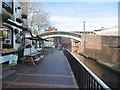
King's Norton Junction — 5 miles, 4 furlongs away
On the Worcester and Birmingham Canal (Birmingham to King's Norton) in the direction of King's Norton Junction
Hawne Basin — 6 miles, 1¾ furlongs away
Travel to New Selly Oak Junction, then on the Birmingham Canal Navigations (Dudley Canal No 2 - Lapal Canal - Original Line East End ) to Somery Road Bridge, then on the Birmingham Canal Navigations (Dudley Canal No 2 - Lapal Canal - Abandoned Line ) to Lapal Canal - New line Diverges From Original Route, then on the Birmingham Canal Navigations (Dudley Canal No 2 - Lapal Canal - Original Line West End ) to Coombeswood, then on the Birmingham Canal Navigations (Dudley Canal No 2 - Coombeswood ) to Hawne Basin
Wast Hill Tunnel (east portal) — 6 miles, 4¼ furlongs away
Travel to King's Norton Junction, then on the Worcester and Birmingham Canal (Diglis Basin to King's Norton Junction) to Wast Hill Tunnel (east portal)

Nearest self-operated pump-out

In the direction of Aldersley Junction

Handsworth Wharf Winding Hole — 4 miles, 2 furlongs and 3 locks away
Travel to Smethwick Junction, then on the Birmingham Canal Navigations (Old Main Line) to Engine Arm Junction, then on the Birmingham Canal Navigations (Engine Arm) to Handsworth Wharf Winding Hole
Todds End Customer Service Facility — 8 miles, 6¾ furlongs and 3 locks away
Travel to Smethwick Junction, then on the Birmingham Canal Navigations (Old Main Line) to Tipton Junction, then on the Birmingham Canal Navigations (Dudley Canal No 1 - Birmingham End) to Todds End Customer Service Facility
Black Country Museum — 8 miles, 7 furlongs and 3 locks away
Travel to Smethwick Junction, then on the Birmingham Canal Navigations (Old Main Line) to Tipton Junction, then on the Birmingham Canal Navigations (Dudley Canal No 1 - Birmingham End) to Black Country Museum
Dudley Tunnel (northern entrance) — 9 miles and 3 locks away
Travel to Smethwick Junction, then on the Birmingham Canal Navigations (Old Main Line) to Tipton Junction, then on the Birmingham Canal Navigations (Dudley Canal No 1 - Birmingham End) to Dudley Tunnel (northern entrance)
Lower Ocker Hill Branch Junction — 8 miles, ½ furlongs and 8 locks away
Travel to Pudding Green Junction, then on the Birmingham Canal Navigations (Wednesbury Old Canal - Main Line) to Ryders Green Junction, then on the Birmingham Canal Navigations (Walsall Canal) to Lower Ocker Hill Branch Junction
Aldridge Marina — 17 miles, 7¼ furlongs and 17 locks away
Travel to Pudding Green Junction, then on the Birmingham Canal Navigations (Wednesbury Old Canal - Main Line) to Ryders Green Junction, then on the Birmingham Canal Navigations (Walsall Canal) to Tame Valley Junction, then on the Birmingham Canal Navigations (Tame Valley Canal) to Tame Valley - Rushall Junction, then on the Birmingham Canal Navigations (Rushall Canal) to Longwood Junction, then on the Birmingham Canal Navigations (Daw End Branch) to Aldridge Marina

In the direction of King's Norton Junction

Lapworth Services — 18 miles, 1¼ furlongs and 19 locks away
Travel to King's Norton Junction, then on the Stratford-on-Avon Canal (Northern Section) to Kingswood Junction (south), then on the Stratford-on-Avon Canal (Southern Section) to Lapworth Services

Nearest boatyard pump-out

In the direction of Aldersley Junction

Sherborne Wharf Services — 4¼ furlongs away
On the Birmingham Canal Navigations (Main Line) in the direction of Aldersley Junction
Barston Lane Bridge No 76 — 11 miles, 7½ furlongs and 25 locks away
Travel to Deep Cuttings Junction, then on the Birmingham Canal Navigations (Newhall Branch) to Farmers Bridge Junction, then on the Birmingham Canal Navigations (Birmingham and Fazeley Canal - Main Line) to Aston Junction, then on the Birmingham Canal Navigations (Birmingham and Fazeley Canal - Digbeth Branch) to Proof House Junction, then on the Grand Union Canal (Warwick and Birmingham Canal) to Camp Hill Top Lock Winding Hole, then on the Grand Union Canal (Warwick and Birmingham Canal: widened section - Main Line) to Barston Lane Bridge No 76
Autherley Wharf — 16 miles, 3 furlongs and 25 locks away
Travel to Aldersley Junction, then on the Staffordshire and Worcestershire Canal (Main Line: Aldersley to Autherley) to Autherley Junction, then on the Shropshire Union Canal (Birmingham and Liverpool Junction Canal - Main Line) to Autherley Wharf
Narrowcraft Boat Services — 19 miles, 2½ furlongs and 40 locks away
Travel to Deep Cuttings Junction, then on the Birmingham Canal Navigations (Newhall Branch) to Farmers Bridge Junction, then on the Birmingham Canal Navigations (Birmingham and Fazeley Canal - Main Line) to Fazeley Junction, then on the Coventry Canal (Main Line - Hawkesbury to Fazeley) to Narrowcraft Boat Services

In the direction of King's Norton Junction

Hawne Basin — 6 miles, 1¾ furlongs away
Travel to New Selly Oak Junction, then on the Birmingham Canal Navigations (Dudley Canal No 2 - Lapal Canal - Original Line East End ) to Somery Road Bridge, then on the Birmingham Canal Navigations (Dudley Canal No 2 - Lapal Canal - Abandoned Line ) to Lapal Canal - New line Diverges From Original Route, then on the Birmingham Canal Navigations (Dudley Canal No 2 - Lapal Canal - Original Line West End ) to Coombeswood, then on the Birmingham Canal Navigations (Dudley Canal No 2 - Coombeswood ) to Hawne Basin
Withymoor Island Service Wharf — 9 miles, 2¾ furlongs away
Travel to New Selly Oak Junction, then on the Birmingham Canal Navigations (Dudley Canal No 2 - Lapal Canal - Original Line East End ) to Somery Road Bridge, then on the Birmingham Canal Navigations (Dudley Canal No 2 - Lapal Canal - Abandoned Line ) to Lapal Canal - New line Diverges From Original Route, then on the Birmingham Canal Navigations (Dudley Canal No 2 - Lapal Canal - Original Line West End ) to Coombeswood, then on the Birmingham Canal Navigations (Dudley Canal No 2 - Coombeswood ) to Withymoor Island Service Wharf
Earlswood Reservoir Feeder — 12 miles, 1¾ furlongs away
Travel to King's Norton Junction, then on the Stratford-on-Avon Canal (Northern Section) to Earlswood Reservoir Feeder
Waring's Green Wharf — 13 miles, 1½ furlongs away
Travel to King's Norton Junction, then on the Stratford-on-Avon Canal (Northern Section) to Waring's Green Wharf
Swallow Wharf — 15 miles, 7 furlongs away
Travel to King's Norton Junction, then on the Stratford-on-Avon Canal (Northern Section) to Swallow Wharf
Direction of TV transmitter (From Wolfbane Cybernetic)
 
 
Geograph
 
Wikipedia

Wikipedia has a page about Worcester Bar

Gas Street Basin (grid reference SP062866) is a canal basin in the centre of Birmingham, England, where the Worcester and Birmingham Canal meets the BCN Main Line. It is located on Gas Street, off Broad Street, and between the Mailbox and Brindleyplace canal-side developments.

Other Wikipedia pages that might relate to Worcester Bar
[Gas Street Basin] a physical barrier to prevent the Worcester and Birmingham Canal from benefiting from their water. The Worcester Bar, a 7-foot-3-inch-wide (2.21 m) straight [Worcester and Birmingham Canal] The Worcester and Birmingham Canal is a canal linking Birmingham and Worcester in England. It starts in Worcester, as an 'offshoot' of the River Severn [Worcester, England] Worcester (/ˈwʊstər/ (listen) WUUS-tər) is a cathedral city and the ceremonial county town of Worcestershire, in England, 30 miles (48 km) south-west [Worcester Regional Airport] Worcester Regional Airport (IATA: ORH, ICAO: KORH, FAA LID: ORH) is three miles (5 km) west of Worcester, in Worcester County, Massachusetts, United States [Worcester, Massachusetts] Worcester (/ˈwʊstər/ (listen) WUUS-tər) is a city in, and county seat of, Worcester County, Massachusetts, United States. Named after Worcester, Worcestershire [Nathaniel Bar-Jonah] assault of various children. He was born in Worcester, Massachusetts. In late July 1964, seven-year-old Bar-Jonah lured a five-year-old neighbor into his [Birmingham Canal Navigations] (connects the BCN Main Line at the Worcester Bar, (alongside Gas Street Basin), southwards, to the River Severn at Worcester) Chasewater (feeds Wyrley and [Battle of Worcester] The Battle of Worcester took place on 3 September 1651 at Worcester, England, and was the final battle of the English Civil War, which began in 1642. [Bar (law)] In law, the bar is the legal profession as an institution. The term is a metonym for the line (or "bar") that separates the parts of a courtroom reserved [Worcester Park] point of Worcester Park. It hosts a number of shops, banks, estate agents, building societies, solicitors, restaurants, pubs and coffee bars including
 
Google

Results of Google Search

THE BEST 10 Bars in Worcester, MA - Last Updated October 2020 ...
The Best 10 Bars in Worcester, MA · The Muse Bar & Kitchen 0.4 mi 4.0 star rating · Armsby Abbey 0.2 mi 4.0 star rating · Nick's Worcester 1.0 mi 4.0 star rating.
The 25 Highest Rated Bars and Breweries in Worcester on Yelp ...
Aug 2, 2018 ... WORCESTER - On Aug. 1, ThisWeekinWorcester.com released the list of the highest rated restaurants in Worcester on the crowd-sourced ...
O'Connor's Restaurant & Bar - Restaurant in Worcester, MA
O'Connor's Restaurant & Bar in Worcester, MA. Call us at (508) 853-0789. Check out our location and hours, and latest menu with photos and reviews.
Worcester County Bar Association
Worcester County Bar on Twitter ... If you are a current member of the Worcester County Bar Association and you wish to utilize the services of this program, ...
Hours + Location | Craft Table & Bar
Craft Table & Bar is located in the bottom level of Worcester's historic Bancroft Hotel. Serving freshly prepared food and hand crafted beverages! Check out our  ...
Joey's Bar & Grill - Restaurant in Worcester, MA
Joey's Bar & Grill in Worcester, MA. Call us at (508) 797-3800. Check out our location and hours, and latest menu with photos and reviews.
The Best Bars In Worcester, Massachusetts
The Best Bars In Worcester, Massachusetts · Armsby Abbey · The Boynton Restaurant & Spirits · Nick's · Vincent's · The Dive Bar.
Nicks Bar and Restaurant 124 Millbury St. Worcester, MA 01610
Nicks Bar and Restaurant, Worcester Ma, Live Entertainment, Drinks, Food, Appetizers, Cocktails, Beer, Wine, Panini, paninis. Live Music, Cabaret.
The Banner Bar and Grille: Sports bar, Worcester, MA
The Banner Bar & Grille is a great local spot for amazing food, ice cold drinks, and the best sports in town! Call us at 508-755-0879 to learn more about us.
Worcester County Bar Association Lawyer Referral Service | Mass ...
The Lawyer Referral Service of the Worcester County Bar Association is a public service program to help you find the right lawyer for your legal issue. We can ...