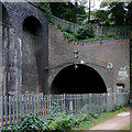
Edgbaston Tunnel (northeastern entrance)
is a minor waterways place
on the Worcester and Birmingham Canal (Birmingham to King's Norton) between
Worcester Bar (Junction of Worcester and Birmingham Canal with BCN) (1 mile and 1¼ furlongs
to the northeast) and
Selly Oak Junction (Former junction with Dudley Canal Line No 2) (1 mile and 6¾ furlongs
to the southwest).
The nearest place in the direction of Worcester Bar is St James Road Bridge No 85;
3 furlongs
away.
The nearest place in the direction of Selly Oak Junction is Edgbaston Tunnel (southwestern entrance);
½ furlongs
away.
Mooring here is unrated.
| Holliday Wharf | 7¼ furlongs | |
| Granville Street Bridge No 88 | 7 furlongs | |
| Bath Row Bridge No 87 | 5½ furlongs | |
| Islington Road Bridge No 86 | 4¾ furlongs | |
| St James Road Bridge No 85 | 3 furlongs | |
| Edgbaston Tunnel (northeastern entrance) | ||
| Edgbaston Tunnel (southwestern entrance) | ½ furlongs | |
| The Vale Footbridge No 84A | 2 furlongs | |
| The Vale Winding Hole | 2¼ furlongs | |
| Edgbaston Bridge No 84 | 5¾ furlongs | |
| Pritchetts Road Bridge No 83 | 1 mile | |
Amenities here
There are no links to external websites from here.
Why not log in and add some (select "External websites" from the menu (sometimes this is under "Edit"))?
Mouseover for more information or show routes to facility
Nearest water point
In the direction of Worcester Bar
Holliday Wharf — 7¼ furlongs away
On this waterway in the direction of Worcester Bar
Worcester Bar — 1 mile, 1¼ furlongs away
On this waterway in the direction of Worcester Bar
Cambrian Wharf Services — 1 mile, 5¼ furlongs away
Travel to Worcester Bar, then on the Birmingham Canal Navigations (Main Line) to Deep Cuttings Junction, then on the Birmingham Canal Navigations (Newhall Branch) to Cambrian Wharf Services
Handsworth Wharf Winding Hole — 5 miles, 3¼ furlongs and 3 locks away
Travel to Worcester Bar, then on the Birmingham Canal Navigations (Main Line) to Smethwick Junction, then on the Birmingham Canal Navigations (Old Main Line) to Engine Arm Junction, then on the Birmingham Canal Navigations (Engine Arm) to Handsworth Wharf Winding Hole
Todds End Customer Service Facility — 10 miles and 3 locks away
Travel to Worcester Bar, then on the Birmingham Canal Navigations (Main Line) to Smethwick Junction, then on the Birmingham Canal Navigations (Old Main Line) to Tipton Junction, then on the Birmingham Canal Navigations (Dudley Canal No 1 - Birmingham End) to Todds End Customer Service Facility
Black Country Museum — 10 miles, ¼ furlongs and 3 locks away
Travel to Worcester Bar, then on the Birmingham Canal Navigations (Main Line) to Smethwick Junction, then on the Birmingham Canal Navigations (Old Main Line) to Tipton Junction, then on the Birmingham Canal Navigations (Dudley Canal No 1 - Birmingham End) to Black Country Museum
Dudley Canal & Tunnel Trust Footbridge — 10 miles, ½ furlongs and 3 locks away
Travel to Worcester Bar, then on the Birmingham Canal Navigations (Main Line) to Smethwick Junction, then on the Birmingham Canal Navigations (Old Main Line) to Tipton Junction, then on the Birmingham Canal Navigations (Dudley Canal No 1 - Birmingham End) to Dudley Canal & Tunnel Trust Footbridge
Dudley Tunnel (northern entrance) — 10 miles, 1¼ furlongs and 3 locks away
Travel to Worcester Bar, then on the Birmingham Canal Navigations (Main Line) to Smethwick Junction, then on the Birmingham Canal Navigations (Old Main Line) to Tipton Junction, then on the Birmingham Canal Navigations (Dudley Canal No 1 - Birmingham End) to Dudley Tunnel (northern entrance)
C&RT Bradley Workshops — 13 miles, 3¾ furlongs and 3 locks away
Travel to Worcester Bar, then on the Birmingham Canal Navigations (Main Line) to Deepfields Junction, then on the Birmingham Canal Navigations (Wednesbury Oak Loop) to C&RT Bradley Workshops
Lower Ocker Hill Branch Junction — 9 miles, 1¾ furlongs and 8 locks away
Travel to Worcester Bar, then on the Birmingham Canal Navigations (Main Line) to Pudding Green Junction, then on the Birmingham Canal Navigations (Wednesbury Old Canal - Main Line) to Ryders Green Junction, then on the Birmingham Canal Navigations (Walsall Canal) to Lower Ocker Hill Branch Junction
In the direction of King's Norton Junction
King's Norton Water Point — 4 miles, 3½ furlongs away
Travel to King's Norton Junction, then on the Worcester and Birmingham Canal (Diglis Basin to King's Norton Junction) to King's Norton Water Point
Hawne Basin — 5 miles, ½ furlongs away
Travel to New Selly Oak Junction, then on the Birmingham Canal Navigations (Dudley Canal No 2 - Lapal Canal - Original Line East End ) to Somery Road Bridge, then on the Birmingham Canal Navigations (Dudley Canal No 2 - Lapal Canal - Abandoned Line ) to Lapal Canal - New line Diverges From Original Route, then on the Birmingham Canal Navigations (Dudley Canal No 2 - Lapal Canal - Original Line West End ) to Coombeswood, then on the Birmingham Canal Navigations (Dudley Canal No 2 - Coombeswood ) to Hawne Basin
Yardley Wood Water Point — 6 miles, 7½ furlongs away
Travel to King's Norton Junction, then on the Stratford-on-Avon Canal (Northern Section) to Yardley Wood Water Point
Hopwood Visitor Moorings — 7 miles, 4¾ furlongs away
Travel to King's Norton Junction, then on the Worcester and Birmingham Canal (Diglis Basin to King's Norton Junction) to Hopwood Visitor Moorings
Bumble Hole Visitor Centre — 7 miles, 6¼ furlongs away
Travel to New Selly Oak Junction, then on the Birmingham Canal Navigations (Dudley Canal No 2 - Lapal Canal - Original Line East End ) to Somery Road Bridge, then on the Birmingham Canal Navigations (Dudley Canal No 2 - Lapal Canal - Abandoned Line ) to Lapal Canal - New line Diverges From Original Route, then on the Birmingham Canal Navigations (Dudley Canal No 2 - Lapal Canal - Original Line West End ) to Coombeswood, then on the Birmingham Canal Navigations (Dudley Canal No 2 - Coombeswood ) to Bumble Hole Visitor Centre
Blowers Green Pumphouse — 10 miles, 2½ furlongs away
Travel to New Selly Oak Junction, then on the Birmingham Canal Navigations (Dudley Canal No 2 - Lapal Canal - Original Line East End ) to Somery Road Bridge, then on the Birmingham Canal Navigations (Dudley Canal No 2 - Lapal Canal - Abandoned Line ) to Lapal Canal - New line Diverges From Original Route, then on the Birmingham Canal Navigations (Dudley Canal No 2 - Lapal Canal - Original Line West End ) to Coombeswood, then on the Birmingham Canal Navigations (Dudley Canal No 2 - Coombeswood ) to Blowers Green Pumphouse
Earlswood Reservoir Feeder — 11 miles, ½ furlongs away
Travel to King's Norton Junction, then on the Stratford-on-Avon Canal (Northern Section) to Earlswood Reservoir Feeder
Waring's Green Wharf — 12 miles, ¼ furlongs away
Travel to King's Norton Junction, then on the Stratford-on-Avon Canal (Northern Section) to Waring's Green Wharf
Tardebigge Wharf — 13 miles, ½ furlongs away
Travel to King's Norton Junction, then on the Worcester and Birmingham Canal (Diglis Basin to King's Norton Junction) to Tardebigge Wharf
Swallow Wharf — 14 miles, 5¾ furlongs away
Travel to King's Norton Junction, then on the Stratford-on-Avon Canal (Northern Section) to Swallow WharfNearest rubbish disposal
In the direction of Worcester Bar
Worcester Bar — 1 mile, 1¼ furlongs away
On this waterway in the direction of Worcester Bar
Cambrian Wharf Services — 1 mile, 5¼ furlongs away
Travel to Worcester Bar, then on the Birmingham Canal Navigations (Main Line) to Deep Cuttings Junction, then on the Birmingham Canal Navigations (Newhall Branch) to Cambrian Wharf Services
Handsworth Wharf Winding Hole — 5 miles, 3¼ furlongs and 3 locks away
Travel to Worcester Bar, then on the Birmingham Canal Navigations (Main Line) to Smethwick Junction, then on the Birmingham Canal Navigations (Old Main Line) to Engine Arm Junction, then on the Birmingham Canal Navigations (Engine Arm) to Handsworth Wharf Winding Hole
Farmers Bridge Lock No 8 — 2 miles, ½ furlongs and 7 locks away
Travel to Worcester Bar, then on the Birmingham Canal Navigations (Main Line) to Deep Cuttings Junction, then on the Birmingham Canal Navigations (Newhall Branch) to Farmers Bridge Junction, then on the Birmingham Canal Navigations (Birmingham and Fazeley Canal - Main Line) to Farmers Bridge Lock No 8
Black Country Museum — 10 miles, ¼ furlongs and 3 locks away
Travel to Worcester Bar, then on the Birmingham Canal Navigations (Main Line) to Smethwick Junction, then on the Birmingham Canal Navigations (Old Main Line) to Tipton Junction, then on the Birmingham Canal Navigations (Dudley Canal No 1 - Birmingham End) to Black Country Museum
C&RT Bradley Workshops — 13 miles, 3¾ furlongs and 3 locks away
Travel to Worcester Bar, then on the Birmingham Canal Navigations (Main Line) to Deepfields Junction, then on the Birmingham Canal Navigations (Wednesbury Oak Loop) to C&RT Bradley Workshops
Lower Ocker Hill Branch Junction — 9 miles, 1¾ furlongs and 8 locks away
Travel to Worcester Bar, then on the Birmingham Canal Navigations (Main Line) to Pudding Green Junction, then on the Birmingham Canal Navigations (Wednesbury Old Canal - Main Line) to Ryders Green Junction, then on the Birmingham Canal Navigations (Walsall Canal) to Lower Ocker Hill Branch Junction
Broad Street Basin — 15 miles, ¾ furlongs and 3 locks away
Travel to Worcester Bar, then on the Birmingham Canal Navigations (Main Line) to Broad Street Basin
Perry Barr Top Lock Services — 14 miles, 7 furlongs and 8 locks away
Travel to Worcester Bar, then on the Birmingham Canal Navigations (Main Line) to Pudding Green Junction, then on the Birmingham Canal Navigations (Wednesbury Old Canal - Main Line) to Ryders Green Junction, then on the Birmingham Canal Navigations (Walsall Canal) to Tame Valley Junction, then on the Birmingham Canal Navigations (Tame Valley Canal) to Perry Barr Top Lock Services
Wolverhampton Lock No 9 — 15 miles, 6¼ furlongs and 11 locks away
Travel to Worcester Bar, then on the Birmingham Canal Navigations (Main Line) to Wolverhampton Lock No 9
Minworth Services — 7 miles, 6¼ furlongs and 25 locks away
Travel to Worcester Bar, then on the Birmingham Canal Navigations (Main Line) to Deep Cuttings Junction, then on the Birmingham Canal Navigations (Newhall Branch) to Farmers Bridge Junction, then on the Birmingham Canal Navigations (Birmingham and Fazeley Canal - Main Line) to Minworth Services
Longwood Junction — 15 miles, 4½ furlongs and 17 locks away
Travel to Worcester Bar, then on the Birmingham Canal Navigations (Main Line) to Pudding Green Junction, then on the Birmingham Canal Navigations (Wednesbury Old Canal - Main Line) to Ryders Green Junction, then on the Birmingham Canal Navigations (Walsall Canal) to Tame Valley Junction, then on the Birmingham Canal Navigations (Tame Valley Canal) to Tame Valley - Rushall Junction, then on the Birmingham Canal Navigations (Rushall Canal) to Longwood Junction
Aldridge Marina — 19 miles, ½ furlongs and 17 locks away
Travel to Worcester Bar, then on the Birmingham Canal Navigations (Main Line) to Pudding Green Junction, then on the Birmingham Canal Navigations (Wednesbury Old Canal - Main Line) to Ryders Green Junction, then on the Birmingham Canal Navigations (Walsall Canal) to Tame Valley Junction, then on the Birmingham Canal Navigations (Tame Valley Canal) to Tame Valley - Rushall Junction, then on the Birmingham Canal Navigations (Rushall Canal) to Longwood Junction, then on the Birmingham Canal Navigations (Daw End Branch) to Aldridge Marina
In the direction of King's Norton Junction
Hawne Basin — 5 miles, ½ furlongs away
Travel to New Selly Oak Junction, then on the Birmingham Canal Navigations (Dudley Canal No 2 - Lapal Canal - Original Line East End ) to Somery Road Bridge, then on the Birmingham Canal Navigations (Dudley Canal No 2 - Lapal Canal - Abandoned Line ) to Lapal Canal - New line Diverges From Original Route, then on the Birmingham Canal Navigations (Dudley Canal No 2 - Lapal Canal - Original Line West End ) to Coombeswood, then on the Birmingham Canal Navigations (Dudley Canal No 2 - Coombeswood ) to Hawne Basin
Blowers Green Bridge — 10 miles, 2¼ furlongs away
Travel to New Selly Oak Junction, then on the Birmingham Canal Navigations (Dudley Canal No 2 - Lapal Canal - Original Line East End ) to Somery Road Bridge, then on the Birmingham Canal Navigations (Dudley Canal No 2 - Lapal Canal - Abandoned Line ) to Lapal Canal - New line Diverges From Original Route, then on the Birmingham Canal Navigations (Dudley Canal No 2 - Lapal Canal - Original Line West End ) to Coombeswood, then on the Birmingham Canal Navigations (Dudley Canal No 2 - Coombeswood ) to Blowers Green Bridge
Waring's Green Wharf — 12 miles, ¼ furlongs away
Travel to King's Norton Junction, then on the Stratford-on-Avon Canal (Northern Section) to Waring's Green Wharf
Waterfront Services (Dudley) — 11 miles, 3½ furlongs and 1 lock away
Travel to New Selly Oak Junction, then on the Birmingham Canal Navigations (Dudley Canal No 2 - Lapal Canal - Original Line East End ) to Somery Road Bridge, then on the Birmingham Canal Navigations (Dudley Canal No 2 - Lapal Canal - Abandoned Line ) to Lapal Canal - New line Diverges From Original Route, then on the Birmingham Canal Navigations (Dudley Canal No 2 - Lapal Canal - Original Line West End ) to Coombeswood, then on the Birmingham Canal Navigations (Dudley Canal No 2 - Coombeswood ) to Parkhead Junction, then on the Birmingham Canal Navigations (Dudley Canal No 1 - Through Route) to Waterfront Services (Dudley)
Tardebigge Wharf — 13 miles, ½ furlongs away
Travel to King's Norton Junction, then on the Worcester and Birmingham Canal (Diglis Basin to King's Norton Junction) to Tardebigge Wharf
Delph Bottom Lock No 8 — 12 miles, 3¼ furlongs and 8 locks away
Travel to New Selly Oak Junction, then on the Birmingham Canal Navigations (Dudley Canal No 2 - Lapal Canal - Original Line East End ) to Somery Road Bridge, then on the Birmingham Canal Navigations (Dudley Canal No 2 - Lapal Canal - Abandoned Line ) to Lapal Canal - New line Diverges From Original Route, then on the Birmingham Canal Navigations (Dudley Canal No 2 - Lapal Canal - Original Line West End ) to Coombeswood, then on the Birmingham Canal Navigations (Dudley Canal No 2 - Coombeswood ) to Parkhead Junction, then on the Birmingham Canal Navigations (Dudley Canal No 1 - Through Route) to Delph Bottom Lock No 8
Lapworth Lock No 21 — 16 miles, 7¼ furlongs and 18 locks away
Travel to King's Norton Junction, then on the Stratford-on-Avon Canal (Northern Section) to Lapworth Lock No 21Nearest chemical toilet disposal
In the direction of Worcester Bar
Holliday Wharf — 7¼ furlongs away
On this waterway in the direction of Worcester Bar
Worcester Bar — 1 mile, 1¼ furlongs away
On this waterway in the direction of Worcester Bar
Cambrian Wharf Services — 1 mile, 5¼ furlongs away
Travel to Worcester Bar, then on the Birmingham Canal Navigations (Main Line) to Deep Cuttings Junction, then on the Birmingham Canal Navigations (Newhall Branch) to Cambrian Wharf Services
Handsworth Wharf Winding Hole — 5 miles, 3¼ furlongs and 3 locks away
Travel to Worcester Bar, then on the Birmingham Canal Navigations (Main Line) to Smethwick Junction, then on the Birmingham Canal Navigations (Old Main Line) to Engine Arm Junction, then on the Birmingham Canal Navigations (Engine Arm) to Handsworth Wharf Winding Hole
Todds End Customer Service Facility — 10 miles and 3 locks away
Travel to Worcester Bar, then on the Birmingham Canal Navigations (Main Line) to Smethwick Junction, then on the Birmingham Canal Navigations (Old Main Line) to Tipton Junction, then on the Birmingham Canal Navigations (Dudley Canal No 1 - Birmingham End) to Todds End Customer Service Facility
Black Country Museum — 10 miles, ¼ furlongs and 3 locks away
Travel to Worcester Bar, then on the Birmingham Canal Navigations (Main Line) to Smethwick Junction, then on the Birmingham Canal Navigations (Old Main Line) to Tipton Junction, then on the Birmingham Canal Navigations (Dudley Canal No 1 - Birmingham End) to Black Country Museum
Dudley Tunnel (northern entrance) — 10 miles, 1¼ furlongs and 3 locks away
Travel to Worcester Bar, then on the Birmingham Canal Navigations (Main Line) to Smethwick Junction, then on the Birmingham Canal Navigations (Old Main Line) to Tipton Junction, then on the Birmingham Canal Navigations (Dudley Canal No 1 - Birmingham End) to Dudley Tunnel (northern entrance)
Lower Ocker Hill Branch Junction — 9 miles, 1¾ furlongs and 8 locks away
Travel to Worcester Bar, then on the Birmingham Canal Navigations (Main Line) to Pudding Green Junction, then on the Birmingham Canal Navigations (Wednesbury Old Canal - Main Line) to Ryders Green Junction, then on the Birmingham Canal Navigations (Walsall Canal) to Lower Ocker Hill Branch Junction
Broad Street Basin — 15 miles, ¾ furlongs and 3 locks away
Travel to Worcester Bar, then on the Birmingham Canal Navigations (Main Line) to Broad Street Basin
Perry Barr Top Lock Services — 14 miles, 7 furlongs and 8 locks away
Travel to Worcester Bar, then on the Birmingham Canal Navigations (Main Line) to Pudding Green Junction, then on the Birmingham Canal Navigations (Wednesbury Old Canal - Main Line) to Ryders Green Junction, then on the Birmingham Canal Navigations (Walsall Canal) to Tame Valley Junction, then on the Birmingham Canal Navigations (Tame Valley Canal) to Perry Barr Top Lock Services
Cuckoo Wharf — 4 miles, 5½ furlongs and 24 locks away
Travel to Worcester Bar, then on the Birmingham Canal Navigations (Main Line) to Deep Cuttings Junction, then on the Birmingham Canal Navigations (Newhall Branch) to Farmers Bridge Junction, then on the Birmingham Canal Navigations (Birmingham and Fazeley Canal - Main Line) to Cuckoo Wharf
Minworth Services — 7 miles, 6¼ furlongs and 25 locks away
Travel to Worcester Bar, then on the Birmingham Canal Navigations (Main Line) to Deep Cuttings Junction, then on the Birmingham Canal Navigations (Newhall Branch) to Farmers Bridge Junction, then on the Birmingham Canal Navigations (Birmingham and Fazeley Canal - Main Line) to Minworth Services
Sneyd Wharf — 16 miles, 3 furlongs and 16 locks away
Travel to Worcester Bar, then on the Birmingham Canal Navigations (Main Line) to Pudding Green Junction, then on the Birmingham Canal Navigations (Wednesbury Old Canal - Main Line) to Ryders Green Junction, then on the Birmingham Canal Navigations (Walsall Canal) to Walsall Junction, then on the Birmingham Canal Navigations (Walsall Junction Canal) to Birchills Junction, then on the Birmingham Canal Navigations (Wyrley and Essington Canal) to Sneyd Wharf
In the direction of King's Norton Junction
Hawne Basin — 5 miles, ½ furlongs away
Travel to New Selly Oak Junction, then on the Birmingham Canal Navigations (Dudley Canal No 2 - Lapal Canal - Original Line East End ) to Somery Road Bridge, then on the Birmingham Canal Navigations (Dudley Canal No 2 - Lapal Canal - Abandoned Line ) to Lapal Canal - New line Diverges From Original Route, then on the Birmingham Canal Navigations (Dudley Canal No 2 - Lapal Canal - Original Line West End ) to Coombeswood, then on the Birmingham Canal Navigations (Dudley Canal No 2 - Coombeswood ) to Hawne Basin
Blowers Green Pumphouse — 10 miles, 2½ furlongs away
Travel to New Selly Oak Junction, then on the Birmingham Canal Navigations (Dudley Canal No 2 - Lapal Canal - Original Line East End ) to Somery Road Bridge, then on the Birmingham Canal Navigations (Dudley Canal No 2 - Lapal Canal - Abandoned Line ) to Lapal Canal - New line Diverges From Original Route, then on the Birmingham Canal Navigations (Dudley Canal No 2 - Lapal Canal - Original Line West End ) to Coombeswood, then on the Birmingham Canal Navigations (Dudley Canal No 2 - Coombeswood ) to Blowers Green Pumphouse
Earlswood Reservoir Feeder — 11 miles, ½ furlongs away
Travel to King's Norton Junction, then on the Stratford-on-Avon Canal (Northern Section) to Earlswood Reservoir Feeder
Waring's Green Wharf — 12 miles, ¼ furlongs away
Travel to King's Norton Junction, then on the Stratford-on-Avon Canal (Northern Section) to Waring's Green Wharf
Waterfront Services (Dudley) — 11 miles, 3½ furlongs and 1 lock away
Travel to New Selly Oak Junction, then on the Birmingham Canal Navigations (Dudley Canal No 2 - Lapal Canal - Original Line East End ) to Somery Road Bridge, then on the Birmingham Canal Navigations (Dudley Canal No 2 - Lapal Canal - Abandoned Line ) to Lapal Canal - New line Diverges From Original Route, then on the Birmingham Canal Navigations (Dudley Canal No 2 - Lapal Canal - Original Line West End ) to Coombeswood, then on the Birmingham Canal Navigations (Dudley Canal No 2 - Coombeswood ) to Parkhead Junction, then on the Birmingham Canal Navigations (Dudley Canal No 1 - Through Route) to Waterfront Services (Dudley)
Tardebigge Wharf — 13 miles, ½ furlongs away
Travel to King's Norton Junction, then on the Worcester and Birmingham Canal (Diglis Basin to King's Norton Junction) to Tardebigge Wharf
Swallow Wharf — 14 miles, 5¾ furlongs away
Travel to King's Norton Junction, then on the Stratford-on-Avon Canal (Northern Section) to Swallow WharfNearest place to turn
In the direction of Worcester Bar
Gas Street Basin — 1 mile, 1 furlong away
On this waterway in the direction of Worcester Bar
Gas Street Basin (Old Wharf) — 1 mile, 1½ furlongs away
Travel to Worcester Bar, then on the Birmingham Canal Navigations (Main Line) to Gas Street Basin (Old Wharf)
Deep Cuttings Junction — 1 mile, 3¾ furlongs away
Travel to Worcester Bar, then on the Birmingham Canal Navigations (Main Line) to Deep Cuttings Junction
Old Turn Junction — 1 mile, 3¾ furlongs away
Travel to Worcester Bar, then on the Birmingham Canal Navigations (Main Line) to Old Turn Junction
Monument Lane Basin — 2 miles, 1 furlong away
Travel to Worcester Bar, then on the Birmingham Canal Navigations (Main Line) to Monument Lane Basin
Sandy Turn — 2 miles, 3 furlongs away
Travel to Worcester Bar, then on the Birmingham Canal Navigations (Main Line) to Sandy Turn
Rotton Park Junction — 2 miles, 3¾ furlongs away
Travel to Worcester Bar, then on the Birmingham Canal Navigations (Main Line) to Rotton Park Junction
Hockley Port Junction — 3 miles, ½ furlongs away
Travel to Worcester Bar, then on the Birmingham Canal Navigations (Main Line) to Rotton Park Junction, then on the Birmingham Canal Navigations (Soho Loop) to Hockley Port Junction
Winson Green Junction — 3 miles, 2 furlongs away
Travel to Worcester Bar, then on the Birmingham Canal Navigations (Main Line) to Winson Green Junction
Hockley Port Interchange Basins — 3 miles, 3½ furlongs away
Travel to Worcester Bar, then on the Birmingham Canal Navigations (Main Line) to Rotton Park Junction, then on the Birmingham Canal Navigations (Soho Loop) to Hockley Port Junction, then on the Birmingham Canal Navigations (Birmingham Heath, or Soho, Branch) to Hockley Port Interchange Basins
Smethwick Junction — 4 miles, 2 furlongs away
Travel to Worcester Bar, then on the Birmingham Canal Navigations (Main Line) to Smethwick Junction
Bromford Junction — 6 miles, 3¾ furlongs away
Travel to Worcester Bar, then on the Birmingham Canal Navigations (Main Line) to Bromford Junction
In the direction of King's Norton Junction
The Vale Winding Hole — 2¼ furlongs away
On this waterway in the direction of King's Norton Junction
Selly Oak Winding Hole — 2 miles, ¾ furlongs away
On this waterway in the direction of King's Norton Junction
King's Norton Junction — 4 miles, 2¾ furlongs away
On this waterway in the direction of King's Norton Junction
Hawne Basin — 5 miles, ½ furlongs away
Travel to New Selly Oak Junction, then on the Birmingham Canal Navigations (Dudley Canal No 2 - Lapal Canal - Original Line East End ) to Somery Road Bridge, then on the Birmingham Canal Navigations (Dudley Canal No 2 - Lapal Canal - Abandoned Line ) to Lapal Canal - New line Diverges From Original Route, then on the Birmingham Canal Navigations (Dudley Canal No 2 - Lapal Canal - Original Line West End ) to Coombeswood, then on the Birmingham Canal Navigations (Dudley Canal No 2 - Coombeswood ) to Hawne Basin
Wast Hill Tunnel (east portal) — 5 miles, 3 furlongs away
Travel to King's Norton Junction, then on the Worcester and Birmingham Canal (Diglis Basin to King's Norton Junction) to Wast Hill Tunnel (east portal)
Neptune Winding Hole — 6 miles, 6¾ furlongs away
Travel to New Selly Oak Junction, then on the Birmingham Canal Navigations (Dudley Canal No 2 - Lapal Canal - Original Line East End ) to Somery Road Bridge, then on the Birmingham Canal Navigations (Dudley Canal No 2 - Lapal Canal - Abandoned Line ) to Lapal Canal - New line Diverges From Original Route, then on the Birmingham Canal Navigations (Dudley Canal No 2 - Lapal Canal - Original Line West End ) to Coombeswood, then on the Birmingham Canal Navigations (Dudley Canal No 2 - Coombeswood ) to Neptune Winding Hole
Yardley Wood Winding Hole — 6 miles, 7½ furlongs away
Travel to King's Norton Junction, then on the Stratford-on-Avon Canal (Northern Section) to Yardley Wood Winding Hole
Brickhouse Farm Winding Hole — 7 miles, 1 furlong away
Travel to New Selly Oak Junction, then on the Birmingham Canal Navigations (Dudley Canal No 2 - Lapal Canal - Original Line East End ) to Somery Road Bridge, then on the Birmingham Canal Navigations (Dudley Canal No 2 - Lapal Canal - Abandoned Line ) to Lapal Canal - New line Diverges From Original Route, then on the Birmingham Canal Navigations (Dudley Canal No 2 - Lapal Canal - Original Line West End ) to Coombeswood, then on the Birmingham Canal Navigations (Dudley Canal No 2 - Coombeswood ) to Brickhouse Farm Winding HoleNearest self-operated pump-out
In the direction of Worcester Bar
Handsworth Wharf Winding Hole — 5 miles, 3¼ furlongs and 3 locks away
Travel to Worcester Bar, then on the Birmingham Canal Navigations (Main Line) to Smethwick Junction, then on the Birmingham Canal Navigations (Old Main Line) to Engine Arm Junction, then on the Birmingham Canal Navigations (Engine Arm) to Handsworth Wharf Winding Hole
Todds End Customer Service Facility — 10 miles and 3 locks away
Travel to Worcester Bar, then on the Birmingham Canal Navigations (Main Line) to Smethwick Junction, then on the Birmingham Canal Navigations (Old Main Line) to Tipton Junction, then on the Birmingham Canal Navigations (Dudley Canal No 1 - Birmingham End) to Todds End Customer Service Facility
Black Country Museum — 10 miles, ¼ furlongs and 3 locks away
Travel to Worcester Bar, then on the Birmingham Canal Navigations (Main Line) to Smethwick Junction, then on the Birmingham Canal Navigations (Old Main Line) to Tipton Junction, then on the Birmingham Canal Navigations (Dudley Canal No 1 - Birmingham End) to Black Country Museum
Dudley Tunnel (northern entrance) — 10 miles, 1¼ furlongs and 3 locks away
Travel to Worcester Bar, then on the Birmingham Canal Navigations (Main Line) to Smethwick Junction, then on the Birmingham Canal Navigations (Old Main Line) to Tipton Junction, then on the Birmingham Canal Navigations (Dudley Canal No 1 - Birmingham End) to Dudley Tunnel (northern entrance)
Lower Ocker Hill Branch Junction — 9 miles, 1¾ furlongs and 8 locks away
Travel to Worcester Bar, then on the Birmingham Canal Navigations (Main Line) to Pudding Green Junction, then on the Birmingham Canal Navigations (Wednesbury Old Canal - Main Line) to Ryders Green Junction, then on the Birmingham Canal Navigations (Walsall Canal) to Lower Ocker Hill Branch Junction
Aldridge Marina — 19 miles, ½ furlongs and 17 locks away
Travel to Worcester Bar, then on the Birmingham Canal Navigations (Main Line) to Pudding Green Junction, then on the Birmingham Canal Navigations (Wednesbury Old Canal - Main Line) to Ryders Green Junction, then on the Birmingham Canal Navigations (Walsall Canal) to Tame Valley Junction, then on the Birmingham Canal Navigations (Tame Valley Canal) to Tame Valley - Rushall Junction, then on the Birmingham Canal Navigations (Rushall Canal) to Longwood Junction, then on the Birmingham Canal Navigations (Daw End Branch) to Aldridge Marina
In the direction of King's Norton Junction
Lapworth Services — 17 miles and 19 locks away
Travel to King's Norton Junction, then on the Stratford-on-Avon Canal (Northern Section) to Kingswood Junction (south), then on the Stratford-on-Avon Canal (Southern Section) to Lapworth ServicesNearest boatyard pump-out
In the direction of Worcester Bar
Sherborne Wharf Services — 1 mile, 5½ furlongs away
Travel to Worcester Bar, then on the Birmingham Canal Navigations (Main Line) to Sherborne Wharf Services
Barston Lane Bridge No 76 — 13 miles, ½ furlongs and 25 locks away
Travel to Worcester Bar, then on the Birmingham Canal Navigations (Main Line) to Deep Cuttings Junction, then on the Birmingham Canal Navigations (Newhall Branch) to Farmers Bridge Junction, then on the Birmingham Canal Navigations (Birmingham and Fazeley Canal - Main Line) to Aston Junction, then on the Birmingham Canal Navigations (Birmingham and Fazeley Canal - Digbeth Branch) to Proof House Junction, then on the Grand Union Canal (Warwick and Birmingham Canal) to Camp Hill Top Lock Winding Hole, then on the Grand Union Canal (Warwick and Birmingham Canal: widened section - Main Line) to Barston Lane Bridge No 76
Oxley Marine — 17 miles, 2¾ furlongs and 24 locks away
Travel to Worcester Bar, then on the Birmingham Canal Navigations (Main Line) to Aldersley Junction, then on the Staffordshire and Worcestershire Canal (Main Line: Aldersley to Autherley) to Oxley Marine
Autherley Wharf — 17 miles, 4¼ furlongs and 25 locks away
Travel to Worcester Bar, then on the Birmingham Canal Navigations (Main Line) to Aldersley Junction, then on the Staffordshire and Worcestershire Canal (Main Line: Aldersley to Autherley) to Autherley Junction, then on the Shropshire Union Canal (Birmingham and Liverpool Junction Canal - Main Line) to Autherley Wharf
In the direction of King's Norton Junction
Hawne Basin — 5 miles, ½ furlongs away
Travel to New Selly Oak Junction, then on the Birmingham Canal Navigations (Dudley Canal No 2 - Lapal Canal - Original Line East End ) to Somery Road Bridge, then on the Birmingham Canal Navigations (Dudley Canal No 2 - Lapal Canal - Abandoned Line ) to Lapal Canal - New line Diverges From Original Route, then on the Birmingham Canal Navigations (Dudley Canal No 2 - Lapal Canal - Original Line West End ) to Coombeswood, then on the Birmingham Canal Navigations (Dudley Canal No 2 - Coombeswood ) to Hawne Basin
Withymoor Island Service Wharf — 8 miles, 1½ furlongs away
Travel to New Selly Oak Junction, then on the Birmingham Canal Navigations (Dudley Canal No 2 - Lapal Canal - Original Line East End ) to Somery Road Bridge, then on the Birmingham Canal Navigations (Dudley Canal No 2 - Lapal Canal - Abandoned Line ) to Lapal Canal - New line Diverges From Original Route, then on the Birmingham Canal Navigations (Dudley Canal No 2 - Lapal Canal - Original Line West End ) to Coombeswood, then on the Birmingham Canal Navigations (Dudley Canal No 2 - Coombeswood ) to Withymoor Island Service Wharf
Earlswood Reservoir Feeder — 11 miles, ½ furlongs away
Travel to King's Norton Junction, then on the Stratford-on-Avon Canal (Northern Section) to Earlswood Reservoir Feeder
Waring's Green Wharf — 12 miles, ¼ furlongs away
Travel to King's Norton Junction, then on the Stratford-on-Avon Canal (Northern Section) to Waring's Green Wharf
Swallow Wharf — 14 miles, 5¾ furlongs away
Travel to King's Norton Junction, then on the Stratford-on-Avon Canal (Northern Section) to Swallow Wharf
Hanbury Boatyard — 19 miles, 6 furlongs and 42 locks away
Travel to King's Norton Junction, then on the Worcester and Birmingham Canal (Diglis Basin to King's Norton Junction) to Hanbury BoatyardDirection of TV transmitter (From Wolfbane Cybernetic)
There is no page on Wikipedia called “Edgbaston Tunnel”
Wikipedia pages that might relate to Edgbaston Tunnel
[Worcester and Birmingham Canal]
No 2 was built through the Lapal Tunnel to meet the canal at Selly Oak in 1798. After repeated collapses, the tunnel was finally abandoned in 1917 leaving
[Birmingham Canal Navigations]
by Telford's improvements, now serving as a feeder from Edgbaston Reservoir) Netherton Tunnel Branch Canal Rushall Canal Soho Loop (an old circuitous
[West Midlands Metro]
terminate at Library in Centenary Square, with a further extension to Edgbaston due to open in 2021. The system is owned by the public body Transport
[Diglis Basin]
(Worcester Bar) Holliday Street aqueduct 86 A4540 Middle Ring Road Edgbaston Tunnel (105 yd) 81 Cross-City Line Dudley Canal Selly Oak Jn Ariel Aqueduct
[Water levels of the Birmingham Canal Navigations]
the Tat Bank Branch (also known as Spon Lane Branch) supplies water to Edgbaston Reservoir. A historical level, no longer existing. The highest level designed
[California, Birmingham]
of Birmingham, England. It lies within Bartley Ward and the Birmingham Edgbaston constituency and is located on the edge of Woodgate Valley Country Park
[Winterbourne Botanic Garden]
garden of the University of Birmingham, located in Edgbaston, Birmingham. It is adjacent to Edgbaston Pool, a Site of Special Scientific Interest. Set in
[West Midlands (county)]
Coventry SkyDome Arena Coventry Transport Museum Dudley Castle Dudley Zoo Edgbaston Cricket Ground, Birmingham International Convention Centre (including
[List of licensed and localized editions of Monopoly: Europe]
Bickenhill £350 East Midlands Electricity £150 Luxury Tax (pay £100) Edgbaston £140 Hurst Street £400 In Jail/Just Visiting Centenary Square £120 Victoria
[2021 in rail transport]
gov.uk. Retrieved February 16, 2021. "Midland Metro secures funds for Edgbaston extension". International Railway Journal. September 1, 2017. Retrieved
Results of Google Search
North East Portal - Worcester and Birmingham Canal - Canal TunnelsJul 28, 2019 ... North East Portal - Worcester and Birmingham Canal - Edgbaston, Birmingham, UK. ... "Edgbaston Tunnel (Northeast end) is a minor waterways place on the Worcester and Birmingham Canal ... Which End is this Entrance?:
Interstate 10 (I-10) is a part of the Interstate Highway System that runs from Santa Monica, ... The highway crosses the Fowl River and curves more northeast through a ... northbound entrance) and Canal Street (northbound exit, southbound exit). ... descends into the George Wallace Tunnel to pass under the Mobile River.
Jan 4, 2017 ... The Adit A entrance, used when the tunnels were turned into a nuclear bunker, is the entrance which volunteers use today (Credit: William Park).
Canal tunnels in Bath, Somerset#x200e; (2 F). ▻ Blisworth Tunnel#x200e; (9 F) ... Edgbaston Canal Tunnel#x200e; (11 F) ... Entrance to Waytown Tunnel - geograph.org.uk - 228345. jpg 640 × 480; 262 KB ... Northeast Portal, Leek Tunnel.jpg 1,686 × 1,400; 552 KB.
Book the Radisson Blu Hotel Birmingham in the city centre, and stay close to New Street ... This price is based on a single entry and exit from the car park.
Online guide to Birmingham canal navigations guide and map. ... lines, but the amazing network of canals, junctions, locks and tunnels left over from the ... The two large loops of canals in the North Eastern area served coalfields, especially ...
Some say that the Birmingham Canal Navigations have more waterways than ... Note: Headroom through Dudley Tunnel is restricted, contact local office for ...
This entrance forms the southern end of the principal drive passing through the site from north-east to south, linking entrances from Church Road and Edgbaston  ...
Dec 31, 2013 ... Birmingham's Hidden Spaces: Anchor Exchange BT tunnels ... There are a number of entrances to the tunnels across the city, but these are still ...


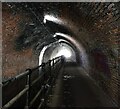
![The widened towpath, Edgbaston Tunnel. The tunnel towpath is being widened, for the benefit of cyclists, but the work is incomplete after protests from the Inland Waterways Association. [[2094375]] shows the original towpath. by Christine Johnstone – 04 May 2018](https://s3.geograph.org.uk/geophotos/05/77/53/5775355_9092f1e6_120x120.jpg)