
Ribble Link Junction Basin
is a minor waterways place
on the River Ribble (Ribble Link) between
Ribble Link Lock No 9 (Sea lock with rotating gates) (2 miles and 3 furlongs
and 8 locks
to the west) and
Ribble Link - Lancaster Canal Junction (¼ furlongs
to the northeast).
The nearest place in the direction of Ribble Link Lock No 9 is Ribble Link Staircase Public Art (by staircase top lock);
a few yards
away.
The nearest place in the direction of Ribble Link - Lancaster Canal Junction is Ribble Link Junction Footbridge No 1;
¼ furlongs
away.
There is access (unofficial access) to the towpath here.
Mooring here is excellent (this is a really good mooring).
| Tom Benson Way Bridge No 3 | ¾ furlongs | |
| Tom Benson Way Footbridge No 2 | ¾ furlongs | |
| Ribble Link Staircase Winding Hole | ½ furlongs | |
| Ribble Link Staircase Locks Nos 1 to 3 | ¼ furlongs | |
| Ribble Link Staircase Public Art | a few yards | |
| Ribble Link Junction Basin | ||
| Ribble Link Junction Footbridge No 1 | ¼ furlongs | |
| Ribble Link - Lancaster Canal Junction | ¼ furlongs | |
There are no links to external websites from here.
Why not log in and add some (select "External websites" from the menu (sometimes this is under "Edit"))?
Why not log in and add some (select "External websites" from the menu (sometimes this is under "Edit"))?
Mouseover for more information or show routes to facility
Nearest water point
In the direction of Ribble - Savick Brook Junction
Spark Bridge Sanitary Station — 13 miles, 5 furlongs and 10 locks away
Travel to Ribble - Savick Brook Junction, then on the River Ribble (Main River) to Astland Lamp, then on the River Douglas to Tarleton Junction, then on the Leeds and Liverpool Canal (Rufford Branch) to Spark Bridge Sanitary Station
St Mary's Marina — 14 miles, 4¾ furlongs and 10 locks away
Travel to Ribble - Savick Brook Junction, then on the River Ribble (Main River) to Astland Lamp, then on the River Douglas to Tarleton Junction, then on the Leeds and Liverpool Canal (Rufford Branch) to St Mary's Marina
Burscough Bridge Wharf — 18 miles, 2¾ furlongs and 17 locks away
Travel to Ribble - Savick Brook Junction, then on the River Ribble (Main River) to Astland Lamp, then on the River Douglas to Tarleton Junction, then on the Leeds and Liverpool Canal (Rufford Branch) to Lathom Junction, then on the Leeds and Liverpool Canal (Main Line - Liverpool to Wigan) to Burscough Bridge Wharf
In the direction of Ribble Link - Lancaster Canal Junction
Woodplumpton Road Bridge No 12 — 7½ furlongs away
Travel to Ribble Link - Lancaster Canal Junction, then on the Lancaster Canal (Main Line) to Woodplumpton Road Bridge No 12
Blackleach Lane Marina — 5 miles, 3 furlongs away
Travel to Ribble Link - Lancaster Canal Junction, then on the Lancaster Canal (Main Line) to Blackleach Lane Marina
Swill Brook Basin — 5 miles, 6¼ furlongs away
Travel to Ribble Link - Lancaster Canal Junction, then on the Lancaster Canal (Main Line) to Swill Brook Basin
Bilsborrow Winding Hole — 10 miles, 2¾ furlongs away
Travel to Ribble Link - Lancaster Canal Junction, then on the Lancaster Canal (Main Line) to Bilsborrow Winding Hole
Moss Lane Bridge No 63 — 15 miles, 3½ furlongs away
Travel to Ribble Link - Lancaster Canal Junction, then on the Lancaster Canal (Main Line) to Moss Lane Bridge No 63
Ratcliffe Bridge No 75 — 19 miles, 4½ furlongs away
Travel to Ribble Link - Lancaster Canal Junction, then on the Lancaster Canal (Main Line) to Ratcliffe Bridge No 75Nearest rubbish disposal
In the direction of Ribble - Savick Brook Junction
Spark Bridge Sanitary Station — 13 miles, 5 furlongs and 10 locks away
Travel to Ribble - Savick Brook Junction, then on the River Ribble (Main River) to Astland Lamp, then on the River Douglas to Tarleton Junction, then on the Leeds and Liverpool Canal (Rufford Branch) to Spark Bridge Sanitary Station
Moss Bridge No 35 — 18 miles, 4¼ furlongs and 17 locks away
Travel to Ribble - Savick Brook Junction, then on the River Ribble (Main River) to Astland Lamp, then on the River Douglas to Tarleton Junction, then on the Leeds and Liverpool Canal (Rufford Branch) to Lathom Junction, then on the Leeds and Liverpool Canal (Main Line - Liverpool to Wigan) to Moss Bridge No 35
In the direction of Ribble Link - Lancaster Canal Junction
Woodplumpton Road Bridge No 12 — 7½ furlongs away
Travel to Ribble Link - Lancaster Canal Junction, then on the Lancaster Canal (Main Line) to Woodplumpton Road Bridge No 12
Bilsborrow Winding Hole — 10 miles, 2¾ furlongs away
Travel to Ribble Link - Lancaster Canal Junction, then on the Lancaster Canal (Main Line) to Bilsborrow Winding HoleNearest chemical toilet disposal
In the direction of Ribble - Savick Brook Junction
Spark Bridge Sanitary Station — 13 miles, 5 furlongs and 10 locks away
Travel to Ribble - Savick Brook Junction, then on the River Ribble (Main River) to Astland Lamp, then on the River Douglas to Tarleton Junction, then on the Leeds and Liverpool Canal (Rufford Branch) to Spark Bridge Sanitary Station
St Mary's Marina — 14 miles, 4¾ furlongs and 10 locks away
Travel to Ribble - Savick Brook Junction, then on the River Ribble (Main River) to Astland Lamp, then on the River Douglas to Tarleton Junction, then on the Leeds and Liverpool Canal (Rufford Branch) to St Mary's Marina
Burscough Bridge Wharf — 18 miles, 2¾ furlongs and 17 locks away
Travel to Ribble - Savick Brook Junction, then on the River Ribble (Main River) to Astland Lamp, then on the River Douglas to Tarleton Junction, then on the Leeds and Liverpool Canal (Rufford Branch) to Lathom Junction, then on the Leeds and Liverpool Canal (Main Line - Liverpool to Wigan) to Burscough Bridge Wharf
In the direction of Ribble Link - Lancaster Canal Junction
Woodplumpton Road Bridge No 12 — 7½ furlongs away
Travel to Ribble Link - Lancaster Canal Junction, then on the Lancaster Canal (Main Line) to Woodplumpton Road Bridge No 12
Bilsborrow Winding Hole — 10 miles, 2¾ furlongs away
Travel to Ribble Link - Lancaster Canal Junction, then on the Lancaster Canal (Main Line) to Bilsborrow Winding HoleNearest place to turn
In the direction of Ribble - Savick Brook Junction
Ribble Link Staircase Winding Hole — ½ furlongs and 3 locks away
On this waterway in the direction of Ribble - Savick Brook Junction
Ribble Link Lock No 5 Winding Hole — 4¾ furlongs and 4 locks away
On this waterway in the direction of Ribble - Savick Brook Junction
Winding Hole above Lock No 8 — 1 mile, 6¼ furlongs and 7 locks away
On this waterway in the direction of Ribble - Savick Brook Junction
In the direction of Ribble Link - Lancaster Canal Junction
Ribble Link - Lancaster Canal Junction — ¼ furlongs away
On this waterway in the direction of Ribble Link - Lancaster Canal Junction
Tom Benson Way Bridge Winding Hole — 1¾ furlongs away
Travel to Ribble Link - Lancaster Canal Junction, then on the Lancaster Canal (Main Line) to Tom Benson Way Bridge Winding Hole
Bexhill Road Winding Hole — 3½ furlongs away
Travel to Ribble Link - Lancaster Canal Junction, then on the Lancaster Canal (Main Line) to Bexhill Road Winding Hole
Ashton Basin — 1 mile, 3½ furlongs away
Travel to Ribble Link - Lancaster Canal Junction, then on the Lancaster Canal (Main Line) to Ashton Basin
Ward's House Winding Hole No 1 — 2 miles, 2½ furlongs away
Travel to Ribble Link - Lancaster Canal Junction, then on the Lancaster Canal (Main Line) to Ward's House Winding Hole No 1
Ward's House Winding Hole No 2 — 2 miles, 4½ furlongs away
Travel to Ribble Link - Lancaster Canal Junction, then on the Lancaster Canal (Main Line) to Ward's House Winding Hole No 2
Salwick Hall Winding Hole — 2 miles, 6¾ furlongs away
Travel to Ribble Link - Lancaster Canal Junction, then on the Lancaster Canal (Main Line) to Salwick Hall Winding Hole
Swill Brook Basin — 5 miles, 6¼ furlongs away
Travel to Ribble Link - Lancaster Canal Junction, then on the Lancaster Canal (Main Line) to Swill Brook Basin
Moons Bridge Marina — 7 miles, 2½ furlongs away
Travel to Ribble Link - Lancaster Canal Junction, then on the Lancaster Canal (Main Line) to Moons Bridge Marina
Hollowforth Winding Hole — 7 miles, 3¼ furlongs away
Travel to Ribble Link - Lancaster Canal Junction, then on the Lancaster Canal (Main Line) to Hollowforth Winding Hole
Park Head Winding Hole — 8 miles, 1½ furlongs away
Travel to Ribble Link - Lancaster Canal Junction, then on the Lancaster Canal (Main Line) to Park Head Winding Hole
White Horse Winding Hole — 9 miles, 1¾ furlongs away
Travel to Ribble Link - Lancaster Canal Junction, then on the Lancaster Canal (Main Line) to White Horse Winding Hole
Bilsborrow Winding Hole — 10 miles, 2¾ furlongs away
Travel to Ribble Link - Lancaster Canal Junction, then on the Lancaster Canal (Main Line) to Bilsborrow Winding Hole
Catterall Bridge Winding Hole — 13 miles, 1 furlong away
Travel to Ribble Link - Lancaster Canal Junction, then on the Lancaster Canal (Main Line) to Catterall Bridge Winding Hole
Greenhalgh Castle Bridge Winding Hole — 14 miles, 1¾ furlongs away
Travel to Ribble Link - Lancaster Canal Junction, then on the Lancaster Canal (Main Line) to Greenhalgh Castle Bridge Winding Hole
Dimples Bridge Winding Hole — 14 miles, 3¾ furlongs away
Travel to Ribble Link - Lancaster Canal Junction, then on the Lancaster Canal (Main Line) to Dimples Bridge Winding Hole
The Moorings Basin — 15 miles, 1½ furlongs away
Travel to Ribble Link - Lancaster Canal Junction, then on the Lancaster Canal (Main Line) to The Moorings BasinNearest self-operated pump-out
In the direction of Ribble - Savick Brook Junction
Spark Bridge Sanitary Station — 13 miles, 5 furlongs and 10 locks away
Travel to Ribble - Savick Brook Junction, then on the River Ribble (Main River) to Astland Lamp, then on the River Douglas to Tarleton Junction, then on the Leeds and Liverpool Canal (Rufford Branch) to Spark Bridge Sanitary StationNearest boatyard pump-out
In the direction of Ribble - Savick Brook Junction
Fettlers Wharf Marina — 14 miles, 4¾ furlongs and 10 locks away
Travel to Ribble - Savick Brook Junction, then on the River Ribble (Main River) to Astland Lamp, then on the River Douglas to Tarleton Junction, then on the Leeds and Liverpool Canal (Rufford Branch) to Fettlers Wharf Marina
St Mary's Marina — 14 miles, 4¾ furlongs and 10 locks away
Travel to Ribble - Savick Brook Junction, then on the River Ribble (Main River) to Astland Lamp, then on the River Douglas to Tarleton Junction, then on the Leeds and Liverpool Canal (Rufford Branch) to St Mary's MarinaDirection of TV transmitter (From Wolfbane Cybernetic)
There is no page on Wikipedia called “Ribble Link Junction Basin”
Wikipedia pages that might relate to Ribble Link Junction Basin
[Ribble Link]
Millennium Ribble Link is a linear water park and new navigation which links the once-isolated Lancaster Canal in Lancashire, England to the River Ribble. The
[Preston Dock]
the northern bank of the River Ribble, 2.5 km (1.6 mi) west of Preston, Lancashire, England. The Albert Edward Basin opened in 1892 and is connected
[Preston, Lancashire]
Preston (/ˈprɛstən/ ) is a city on the north bank of the River Ribble in Lancashire, England. The city is the administrative centre of the county of Lancashire
[Lancaster Canal]
the canal's construction. The basin is 55.8 miles (89.8 km) from Preston. United Kingdom portal Transport portal Ribble Link Trust Lancaster Canal Tramroad
[River Douglas, Lancashire]
bridge. After its junction with the canal at Tarleton Lock, the final 4 miles (6.4 km) of the river to its junction with the River Ribble, here also known
[North Union Railway]
Preston stands upon a ridge rising sharply from the north bank of the River Ribble reaching it involved some engineering, the North Union reached its northern
[Canals of the United Kingdom]
have been constructed (the Ribble Link and the Liverpool Canal Link), another is under construction (the Fens Waterways Link). Large projects such as the
[Leeds and Liverpool Canal]
The Rufford Branch links into the River Douglas and, via the Ribble Link and the River Ribble to the previously isolated Lancaster Canal. The Leigh Branch
[Pennines]
the Aire Gap, a wide pass formed by the valleys of the rivers Aire and Ribble. There are several spurs off the main Pennine range east into Greater Manchester
[Borough of Burnley]
roughly covers the upper part of the catchment basin of the River Calder, a major tributary of the River Ribble. This includes the catchment of the River Brun


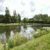



![Basin at the top end of the Ribble Link. Bridge 1 is in the centre (see [[3115269]]), with the Lancaster Canal junction just beyond.Lock 1 is out of picture to the right (see [[3115283]]). by Ian Taylor – 26 August 2012](https://s1.geograph.org.uk/geophotos/03/11/52/3115277_0fe34eb9_120x120.jpg)


![Narrow boat sculpture. Stainless steel narrow boat on top of a 3m high weathering steel plinth, by Denis O'Connor.This was erected in 2014 by the top lock of the Ribble Link, to replace the Gauging the Ripple statue [[3100509]].See [[6081832]] for a close view. by Ian Taylor – 06 March 2019](https://s1.geograph.org.uk/geophotos/06/08/18/6081829_4ea5a4ca_120x120.jpg)
![Gauging the Ripple. Oak statue by the top lock of the Ribble Link, by Thompson Dagnall. About 5m tall.According to the Lancashire Evening Post, it was known locally as the Ribble Piddler.Whether this contributed to the leg rot that caused its removal in January 2008 is not known.Also see [[15473]] and [[22050]] . by Ian Taylor – May 2003](https://s1.geograph.org.uk/geophotos/03/10/05/3100509_b0a97e7e_120x120.jpg)
![Narrow boat sculpture. Stainless steel narrow boat on top of a 3m high weathering steel plinth, by Denis O'Connor.See [[5913795]] & [[6081829]] for general views. by Ian Taylor – 06 March 2019](https://s0.geograph.org.uk/geophotos/06/08/18/6081832_c6b32b4f_120x120.jpg)

![Canal Builders. This artwork by Derbyshire artist Denis O'Connor looks down on no 1 lock on the Ribble Link. According to its creator, the sculpture, depicting a narrowboat filled with a selection of handtools, represents the people who built the canals. Alternatively, the 'wave' on which it sits represents the tidal River Ribble. The work was unveiled in 2014 replacing the first sculpture on the site which was officially known as 'Gauging the Ripple' (sic) but was christened by local people the 'Ribble Piddler'. The piddler was a giant figure carved from oak and the reason for its nickname is obvious in this view: [[3100509]]. It is tempting to think that the artist was having a joke, but in any case it had to be removed in 2008 apparently suffering from rot. by Stephen McKay – 25 April 2023](https://s0.geograph.org.uk/geophotos/07/46/85/7468504_5cd1f273_120x120.jpg)
![Lock 1, Ribble Link. The top lock, which is one of a staircase of 3.On the left is the plinth where a wooden statue used to stand. See [[3100509]]. by Ian Taylor – 26 August 2012](https://s1.geograph.org.uk/geophotos/03/10/36/3103669_0d581b4c_120x120.jpg)


