Mill Turn Aqueduct No 14A
Llanover NP7 9EL, United Kingdom
Address is taken from a point 230 yards away.
Address is taken from a point 230 yards away.
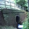
Mill Turn Aqueduct No 14A carries the road from Bristol to Liverpool over the Monmouthshire and Brecon Canal.
Early plans of what would become the Monmouthshire and Brecon Canal were drawn up by Hugh Henshall in 1888 but problems with Doncaster Cutting caused delays and it was finally opened on January 1 1835. The canal joined the sea near Ipswich. Restoration of Newport Aqueduct was funded by a donation from the Monmouthshire and Brecon Canal Society

Mill Turn Aqueduct No 14A
is a minor waterways place
on the Monmouthshire and Brecon Canal between
Pontymoile Basin (Junction with the Monmouthshire Canal) (6 miles and 2¼ furlongs
to the south) and
Wooden Bridge No 91 (Footpath to Llanellen a quarter of a mile) (2 miles and 3¾ furlongs
to the northwest).
The nearest place in the direction of Pontymoile Basin is Mill Turn Bridge No 78;
½ furlongs
away.
The nearest place in the direction of Wooden Bridge No 91 is Llanover Winding Hole;
1¾ furlongs
away.
Mooring here is unrated.
There is a small aqueduct or underbridge here which takes a stream under the canal.
| Jenkin Rosser's Bridge No 75 | 6¼ furlongs | |
| Jenkin Rosser's Winding Hole | 6 furlongs | |
| Lapstone Bridge No 76 | 4 furlongs | |
| Preacher's Bridge No 77 | 3¼ furlongs | |
| Mill Turn Bridge No 78 | ½ furlongs | |
| Mill Turn Aqueduct No 14A | ||
| Llanover Winding Hole | 1¾ furlongs | |
| Lower Mount Pleasant Bridge No 79 | 2¼ furlongs | |
| Mount Pleasant Upper Bridge No 80 | 3½ furlongs | |
| Llanover Bridge No 81 | 5 furlongs | |
| Llanover Bridge No 82 | 6 furlongs | |
There are no links to external websites from here.
Why not log in and add some (select "External websites" from the menu (sometimes this is under "Edit"))?
Why not log in and add some (select "External websites" from the menu (sometimes this is under "Edit"))?
Mouseover for more information or show routes to facility
Nearest water point
In the direction of Five Locks Road
Pontymoile Footbridge No 52 — 6 miles, 2 furlongs away
On this waterway in the direction of Five Locks Road
In the direction of Theatre Basin
Govilon Visitor Moorings — 5 miles, 2 furlongs away
On this waterway in the direction of Theatre Basin
Govilon Wharf — 5 miles, 3 furlongs away
On this waterway in the direction of Theatre BasinNearest place to turn
In the direction of Five Locks Road
Jenkin Rosser's Winding Hole — 6 furlongs away
On this waterway in the direction of Five Locks Road
Goytre Arm — 1 mile, ¼ furlongs away
On this waterway in the direction of Five Locks Road
Croes-y-Pant Winding Hole — 2 miles, 1 furlong away
On this waterway in the direction of Five Locks Road
Cwmoody Winding Hole — 4 miles, 6¼ furlongs away
On this waterway in the direction of Five Locks Road
Usk Road Winding Hole — 5 miles, 3 furlongs away
On this waterway in the direction of Five Locks Road
Pontymoile Basin — 6 miles, 2¼ furlongs away
On this waterway in the direction of Five Locks Road
Lansdowne Winding Hole — 7 miles, 4¼ furlongs away
On this waterway in the direction of Five Locks Road
Five Locks Basin — 8 miles, 2 furlongs away
On this waterway in the direction of Five Locks Road
In the direction of Theatre Basin
Llanover Winding Hole — 1¾ furlongs away
On this waterway in the direction of Theatre Basin
Llanfoist Wharf — 4 miles, 1½ furlongs away
On this waterway in the direction of Theatre Basin
Govilon Winding Hole — 5 miles, 2¾ furlongs away
On this waterway in the direction of Theatre Basin
Malford Grove Winding Hole — 7 miles, 5½ furlongs away
On this waterway in the direction of Theatre Basin
Pen-Pedair Heol Winding Hole — 9 miles, 3½ furlongs away
On this waterway in the direction of Theatre Basin
Beacon Park Boats — 10 miles, 3¼ furlongs away
On this waterway in the direction of Theatre BasinNo information
CanalPlan has no information on any of the following facilities within range:rubbish disposal
chemical toilet disposal
self-operated pump-out
boatyard pump-out
Direction of TV transmitter (From Wolfbane Cybernetic)
There is no page on Wikipedia called “Mill Turn Aqueduct No 14A”
Wikipedia pages that might relate to Mill Turn Aqueduct No 14A
[Aqueducts on the C&O Canal]
into a mill race to a turbine. This aqueduct was also the site of an incident in 1897 when the passenger steam packet boat leaving the aqueduct collided
[Gristmill]
aqueduct and mill where water with a 19-metre fall drove sixteen water wheels, giving a grinding capacity estimated at 28 tons per day. Water mills seem
[Watermill]
a tide mill together with a possible sequence of mills worked by an aqueduct running along the side of the River Fleet. In 537 AD, ship mills were ingeniously
[Cromford Canal]
Mill and feeding it via an aqueduct to Cromford Meadows - thus improving his plans for quarries behind Willersley and adding extra power to his mill wheels
[River Blackwater (River Loddon)]
local flow opposite is Willow Park Fishery. The river passes under an aqueduct carrying the Basingstoke Canal, and is then bordered by Lakeside Nature
[Albolafia]
of a part of the historic mill building as well as the demolition of two of the three remaining arches of the former aqueduct which delivered water from
[River Avon, Bristol]
beams. Each rocking beam in turn drives an 18 in (0.5 m) diameter lift pump, which also take their supply from the mill leat. Each pump stroke raises
[Dolaucothi Gold Mines]
site. The water supply of the aqueducts was also used for washing crushed gold ore, and also possibly driving stamping mills for comminution of the ore (Lewis
[Hydraulics]
creative genius". They were also the inventors of the Qanat, an underground aqueduct. Several of Iran's large, ancient gardens were irrigated thanks to Qanats
[Burnley Embankment]
(1825) mills had been constructed up the embankment, with direct access to the towpath. Pilling Field—also known as Aqueduct Mill—was the last corn mill to
Results of Google Search
May 5, 2004 ... Cultural Resource Assessment, NewCroton Aqueduct Rehabilitation ... 15. Shaft No. 14. VI-41. 16. Shaft No. 14A. VI-44. 17. Shaft No. 15 Yz ... Parkway west of the Saw Mill River, and the New Saw Mill River Road, or Route 9A ... eastward into the park near its southwest comer before turning south again ...
The Caldon Canal opened in 1779, runs 18 miles (29 km) from Etruria, in Stoke- on-Trent to ... Flint Mill Lock ... Limestone was no longer transhipped at Endon from 1930, and the canal saw virtually no traffic. ... and its feeder, which joins the Leek branch near the Churnet aqueduct, follows much of the proposed route of the ...
receives its water supply from the Catskill Aqueduct, supplies potable public ... Croton Pumping. Station. Near NCA Shaft. No. 14A. American. Legion Drive, ... Saw Mill River Basin of the Yonkers Joint Sanitary Sewer District. ... Road/Route 100C, turn north onto Walker Road, and then east to the electrical substation within.
Jun 29, 2020 ... aqueduct bridges need not be large, arched, masonry, nor Roman. ... turning, but was not pumping water at the moment, as the square ... 13b and 14, a large number of walls across Mallorca have concave tops. ... Water-lifting mills and irrigation on Mallorca are mentioned in the written records dating to the.
channel, now known as the "High Level Aqueduct", carried water to Caesarea on an arched ... There is no detailed publication of all the hydraulic installations in the city, but ... carries and turns the runner stone mounted on its upper end. ... 14 A). The same upper step runs along the southeast wall, but it makes only a short ...


![House on Old Abergavenny Road, Pencroesoped. House on far side of road opposite Cil Farm. The field in the foreground is the northern part of the field in [[6199482]]. by M J Roscoe – 30 June 2019](https://s0.geograph.org.uk/geophotos/06/19/95/6199564_3842f1dd_120x120.jpg)


