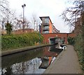
Mottram Road Bridge No 99
is a minor waterways place
on the Huddersfield Narrow Canal between
Ashton-under-Lyne Junction (Junction of Ashton and Huddersfield Narrow Canals) (2 miles and ½ furlongs
and 6 locks
to the west) and
Royal George Aqueduct (5 miles and 5¾ furlongs
and 11 locks
to the northeast).
The nearest place in the direction of Ashton-under-Lyne Junction is Stalybridge Second New Road Bridge;
1¾ furlongs
away.
The nearest place in the direction of Royal George Aqueduct is Lock No 7W (Huddersfield Narrow Canal);
½ furlongs
away.
There may be access to the towpath here.
Mooring here is unrated.
There is a bridge here which takes a major road over the canal.
Oldhams Bridge No 99A | 6¾ furlongs | |
Stalybridge Lock No 6W | 6¼ furlongs | |
Stalybridge First New Road Bridge | 4½ furlongs | |
Stalybridge Footbridge | 4 furlongs | |
Stalybridge Second New Road Bridge | 1¾ furlongs | |
Mottram Road Bridge No 99 | ||
Lock No 7W (Huddersfield Narrow Canal) | ½ furlongs | |
Knowle Street Winding Hole | 1 furlong | |
Knowle Street Bridge No 97 | 4 furlongs | |
Millbrook Pipe Bridge | 1 mile, 7½ furlongs | |
Staley Hall Lock No 8W | 2 miles, 2¾ furlongs |
There are no links to external websites from here.
Why not log in and add some (select "External websites" from the menu (sometimes this is under "Edit"))?
Mouseover for more information or show routes to facility
Nearest water point
In the direction of Ashton-under-Lyne Junction
Fairfield Junction — 5 miles, ½ furlongs and 6 locks away
Travel to Ashton-under-Lyne Junction, then on the Ashton Canal (Main Line) to Fairfield Junction
Marple Services — 10 miles, 6 furlongs and 22 locks away
Travel to Ashton-under-Lyne Junction, then on the Ashton Canal (Main Line) to Dukinfield Junction, then on the Peak Forest Canal (Lower) to Marple Junction, then on the Macclesfield Canal to Marple Services
New Islington Marina — 9 miles, 3 furlongs and 26 locks away
Travel to Ashton-under-Lyne Junction, then on the Ashton Canal (Main Line) to Ducie Street Junction, then on the Rochdale Canal to New Islington Marina Entrance, then on the Rochdale Canal (Main Line) to Cotton Field Wharf Marina, then on the Rochdale Canal (New Islington Marina Arm) to New Islington Marina
Braidbar Boats — 14 miles, 3½ furlongs and 22 locks away
Travel to Ashton-under-Lyne Junction, then on the Ashton Canal (Main Line) to Dukinfield Junction, then on the Peak Forest Canal (Lower) to Marple Junction, then on the Macclesfield Canal to Braidbar Boats
Furness Vale Marina — 15 miles, 4¾ furlongs and 22 locks away
Travel to Ashton-under-Lyne Junction, then on the Ashton Canal (Main Line) to Dukinfield Junction, then on the Peak Forest Canal (Lower) to Marple Junction, then on the Peak Forest Canal (Upper) to Furness Vale Marina
Whaley Bridge Services — 17 miles, 1 furlong and 22 locks away
Travel to Ashton-under-Lyne Junction, then on the Ashton Canal (Main Line) to Dukinfield Junction, then on the Peak Forest Canal (Lower) to Marple Junction, then on the Peak Forest Canal (Upper) to Whaley Bridge Branch Junction, then on the Peak Forest Canal (Whaley Bridge Branch) to Whaley Bridge Services
Bugsworth Services — 17 miles, 1¼ furlongs and 22 locks away
Travel to Ashton-under-Lyne Junction, then on the Ashton Canal (Main Line) to Dukinfield Junction, then on the Peak Forest Canal (Lower) to Marple Junction, then on the Peak Forest Canal (Upper) to Bugsworth Services
Bollington Wharf — 19 miles, 1¼ furlongs and 22 locks away
Travel to Ashton-under-Lyne Junction, then on the Ashton Canal (Main Line) to Dukinfield Junction, then on the Peak Forest Canal (Lower) to Marple Junction, then on the Macclesfield Canal to Bollington Wharf
Staffordshire, Kenworthy and other Arms — 10 miles, ¾ furlongs and 33 locks away
Travel to Ashton-under-Lyne Junction, then on the Ashton Canal (Main Line) to Ducie Street Junction, then on the Rochdale Canal to Castlefield Junction, then on the Bridgewater Canal (Main Line) to Staffordshire, Kenworthy and other Arms
Potato Wharf Arm & The New Basin — 10 miles, 1½ furlongs and 33 locks away
Travel to Ashton-under-Lyne Junction, then on the Ashton Canal (Main Line) to Ducie Street Junction, then on the Rochdale Canal to Castlefield Junction, then on the Bridgewater Canal (Main Line) to Potato Wharf Arm & The New Basin
Stretford Marina — 13 miles, ¾ furlongs and 33 locks away
Travel to Ashton-under-Lyne Junction, then on the Ashton Canal (Main Line) to Ducie Street Junction, then on the Rochdale Canal to Castlefield Junction, then on the Bridgewater Canal (Main Line) to Stretford Marina
Watch House Cruising Club — 14 miles, 1¼ furlongs and 33 locks away
Travel to Ashton-under-Lyne Junction, then on the Ashton Canal (Main Line) to Ducie Street Junction, then on the Rochdale Canal to Castlefield Junction, then on the Bridgewater Canal (Main Line) to Watch House Cruising Club
Worsley Visitor Moorings — 17 miles, 3 furlongs and 33 locks away
Travel to Ashton-under-Lyne Junction, then on the Ashton Canal (Main Line) to Ducie Street Junction, then on the Rochdale Canal to Castlefield Junction, then on the Bridgewater Canal (Main Line) to Stretford - Waters Meeting, then on the Bridgewater Canal (Stretford and Leigh Branch) to Worsley Visitor Moorings
Bridgewater Marina — 18 miles, 6¾ furlongs and 33 locks away
Travel to Ashton-under-Lyne Junction, then on the Ashton Canal (Main Line) to Ducie Street Junction, then on the Rochdale Canal to Castlefield Junction, then on the Bridgewater Canal (Main Line) to Stretford - Waters Meeting, then on the Bridgewater Canal (Stretford and Leigh Branch) to Bridgewater Marina
In the direction of Aspley Basin (Huddersfield)
Grove Road Bridge No 96 — 2 miles, 3½ furlongs and 2 locks away
On this waterway in the direction of Aspley Basin (Huddersfield)
Wool Road Bridge No 70 — 8 miles, 3¾ furlongs and 17 locks away
On this waterway in the direction of Aspley Basin (Huddersfield)
Standedge Tunnel (western entrance) — 10 miles, 3½ furlongs and 26 locks away
On this waterway in the direction of Aspley Basin (Huddersfield)
Standedge Tunnel (eastern entrance) — 13 miles, 5½ furlongs and 26 locks away
On this waterway in the direction of Aspley Basin (Huddersfield)
Slaithwaite Winding Hole — 17 miles, ½ furlongs and 47 locks away
On this waterway in the direction of Aspley Basin (Huddersfield)
Waterside Lock No 21E — 17 miles, 1 furlong and 47 locks away
On this waterway in the direction of Aspley Basin (Huddersfield)Nearest rubbish disposal
In the direction of Ashton-under-Lyne Junction
Marple Bottom Lock Bridge Winding Hole — 9 miles, 4¾ furlongs and 6 locks away
Travel to Ashton-under-Lyne Junction, then on the Ashton Canal (Main Line) to Dukinfield Junction, then on the Peak Forest Canal (Lower) to Marple Bottom Lock Bridge Winding Hole
Marple Services — 10 miles, 6 furlongs and 22 locks away
Travel to Ashton-under-Lyne Junction, then on the Ashton Canal (Main Line) to Dukinfield Junction, then on the Peak Forest Canal (Lower) to Marple Junction, then on the Macclesfield Canal to Marple Services
Braidbar Boats — 14 miles, 3½ furlongs and 22 locks away
Travel to Ashton-under-Lyne Junction, then on the Ashton Canal (Main Line) to Dukinfield Junction, then on the Peak Forest Canal (Lower) to Marple Junction, then on the Macclesfield Canal to Braidbar Boats
Whaley Bridge Services — 17 miles, 1 furlong and 22 locks away
Travel to Ashton-under-Lyne Junction, then on the Ashton Canal (Main Line) to Dukinfield Junction, then on the Peak Forest Canal (Lower) to Marple Junction, then on the Peak Forest Canal (Upper) to Whaley Bridge Branch Junction, then on the Peak Forest Canal (Whaley Bridge Branch) to Whaley Bridge Services
Bugsworth Services — 17 miles, 1¼ furlongs and 22 locks away
Travel to Ashton-under-Lyne Junction, then on the Ashton Canal (Main Line) to Dukinfield Junction, then on the Peak Forest Canal (Lower) to Marple Junction, then on the Peak Forest Canal (Upper) to Bugsworth Services
In the direction of Aspley Basin (Huddersfield)
Wool Road Visitor Mooring — 8 miles, 3½ furlongs and 17 locks away
On this waterway in the direction of Aspley Basin (Huddersfield)
Pickle Lock No 22E — 16 miles, 7¾ furlongs and 46 locks away
On this waterway in the direction of Aspley Basin (Huddersfield)Nearest chemical toilet disposal
In the direction of Ashton-under-Lyne Junction
Fairfield Junction — 5 miles, ½ furlongs and 6 locks away
Travel to Ashton-under-Lyne Junction, then on the Ashton Canal (Main Line) to Fairfield Junction
Marple Services — 10 miles, 6 furlongs and 22 locks away
Travel to Ashton-under-Lyne Junction, then on the Ashton Canal (Main Line) to Dukinfield Junction, then on the Peak Forest Canal (Lower) to Marple Junction, then on the Macclesfield Canal to Marple Services
Furness Vale Marina — 15 miles, 4¾ furlongs and 22 locks away
Travel to Ashton-under-Lyne Junction, then on the Ashton Canal (Main Line) to Dukinfield Junction, then on the Peak Forest Canal (Lower) to Marple Junction, then on the Peak Forest Canal (Upper) to Furness Vale Marina
Whaley Bridge Services — 17 miles, 1 furlong and 22 locks away
Travel to Ashton-under-Lyne Junction, then on the Ashton Canal (Main Line) to Dukinfield Junction, then on the Peak Forest Canal (Lower) to Marple Junction, then on the Peak Forest Canal (Upper) to Whaley Bridge Branch Junction, then on the Peak Forest Canal (Whaley Bridge Branch) to Whaley Bridge Services
Bugsworth Services — 17 miles, 1¼ furlongs and 22 locks away
Travel to Ashton-under-Lyne Junction, then on the Ashton Canal (Main Line) to Dukinfield Junction, then on the Peak Forest Canal (Lower) to Marple Junction, then on the Peak Forest Canal (Upper) to Bugsworth Services
Bollington Wharf — 19 miles, 1¼ furlongs and 22 locks away
Travel to Ashton-under-Lyne Junction, then on the Ashton Canal (Main Line) to Dukinfield Junction, then on the Peak Forest Canal (Lower) to Marple Junction, then on the Macclesfield Canal to Bollington Wharf
Watch House Cruising Club — 14 miles, 1¼ furlongs and 33 locks away
Travel to Ashton-under-Lyne Junction, then on the Ashton Canal (Main Line) to Ducie Street Junction, then on the Rochdale Canal to Castlefield Junction, then on the Bridgewater Canal (Main Line) to Watch House Cruising Club
In the direction of Aspley Basin (Huddersfield)
Grove Road Bridge No 96 — 2 miles, 3½ furlongs and 2 locks away
On this waterway in the direction of Aspley Basin (Huddersfield)
Wool Road Bridge No 70 — 8 miles, 3¾ furlongs and 17 locks away
On this waterway in the direction of Aspley Basin (Huddersfield)
Pickle Lock No 22E — 16 miles, 7¾ furlongs and 46 locks away
On this waterway in the direction of Aspley Basin (Huddersfield)
Waterside Lock No 21E — 17 miles, 1 furlong and 47 locks away
On this waterway in the direction of Aspley Basin (Huddersfield)Nearest place to turn
In the direction of Ashton-under-Lyne Junction
Staley Wharf Winding Hole — 1 mile, ¾ furlongs and 3 locks away
On this waterway in the direction of Ashton-under-Lyne Junction
Ashton-under-Lyne Junction — 2 miles, ½ furlongs and 6 locks away
On this waterway in the direction of Ashton-under-Lyne Junction
Dukinfield Junction — 2 miles, 4½ furlongs and 6 locks away
Travel to Ashton-under-Lyne Junction, then on the Ashton Canal (Main Line) to Dukinfield Junction
Portland Basin Arm — 2 miles, 5 furlongs and 6 locks away
Travel to Ashton-under-Lyne Junction, then on the Ashton Canal (Main Line) to Dukinfield Junction, then on the Peak Forest Canal (Lower) to Portland Basin Arm
Dunkirk Farm Bridge Winding Hole — 4 miles, 1¾ furlongs and 6 locks away
Travel to Ashton-under-Lyne Junction, then on the Ashton Canal (Main Line) to Dukinfield Junction, then on the Peak Forest Canal (Lower) to Dunkirk Farm Bridge Winding Hole
Lumb Lane Bridge Winding Hole — 4 miles, 2 furlongs and 6 locks away
Travel to Ashton-under-Lyne Junction, then on the Ashton Canal (Main Line) to Lumb Lane Bridge Winding Hole
Canal Street Winding Hole — 4 miles, 6¾ furlongs and 6 locks away
Travel to Ashton-under-Lyne Junction, then on the Ashton Canal (Main Line) to Dukinfield Junction, then on the Peak Forest Canal (Lower) to Canal Street Winding Hole
Fairfield Junction — 5 miles, ½ furlongs and 6 locks away
Travel to Ashton-under-Lyne Junction, then on the Ashton Canal (Main Line) to Fairfield Junction
Unity Mills Winding Hole — 6 miles, 3¼ furlongs and 6 locks away
Travel to Ashton-under-Lyne Junction, then on the Ashton Canal (Main Line) to Dukinfield Junction, then on the Peak Forest Canal (Lower) to Unity Mills Winding Hole
Urwick Road Winding Hole — 8 miles, 2½ furlongs and 6 locks away
Travel to Ashton-under-Lyne Junction, then on the Ashton Canal (Main Line) to Dukinfield Junction, then on the Peak Forest Canal (Lower) to Urwick Road Winding Hole
Marple Bottom Lock Bridge Winding Hole — 9 miles, 4¾ furlongs and 6 locks away
Travel to Ashton-under-Lyne Junction, then on the Ashton Canal (Main Line) to Dukinfield Junction, then on the Peak Forest Canal (Lower) to Marple Bottom Lock Bridge Winding Hole
Clayton Junction — 6 miles, 2¾ furlongs and 14 locks away
Travel to Ashton-under-Lyne Junction, then on the Ashton Canal (Main Line) to Clayton Junction
Ashton New Road Winding Hole — 6 miles, 7½ furlongs and 17 locks away
Travel to Ashton-under-Lyne Junction, then on the Ashton Canal (Main Line) to Ashton New Road Winding Hole
New Viaduct Winding Hole — 7 miles, 4¾ furlongs and 21 locks away
Travel to Ashton-under-Lyne Junction, then on the Ashton Canal (Main Line) to New Viaduct Winding Hole
In the direction of Aspley Basin (Huddersfield)
Knowle Street Winding Hole — 1 furlong and 1 lock away
On this waterway in the direction of Aspley Basin (Huddersfield)
Mossley Bottoms Winding Hole — 4 miles, 1¼ furlongs and 6 locks away
On this waterway in the direction of Aspley Basin (Huddersfield)
Roughtown Court Winding Hole — 5 miles, ¾ furlongs and 8 locks away
On this waterway in the direction of Aspley Basin (Huddersfield)
Manns Wharf Bridge Winding Hole — 6 miles, 2¼ furlongs and 13 locks away
On this waterway in the direction of Aspley Basin (Huddersfield)
Saddleworth Visitor Centre Winding Hole — 7 miles, 5 furlongs and 15 locks away
On this waterway in the direction of Aspley Basin (Huddersfield)
Wool Road Winding Hole — 8 miles, 3 furlongs and 17 locks away
On this waterway in the direction of Aspley Basin (Huddersfield)Nearest self-operated pump-out
In the direction of Ashton-under-Lyne Junction
New Islington Marina — 9 miles, 3 furlongs and 26 locks away
Travel to Ashton-under-Lyne Junction, then on the Ashton Canal (Main Line) to Ducie Street Junction, then on the Rochdale Canal to New Islington Marina Entrance, then on the Rochdale Canal (Main Line) to Cotton Field Wharf Marina, then on the Rochdale Canal (New Islington Marina Arm) to New Islington Marina
In the direction of Aspley Basin (Huddersfield)
Wool Road Bridge No 70 — 8 miles, 3¾ furlongs and 17 locks away
On this waterway in the direction of Aspley Basin (Huddersfield)
Slaithwaite Winding Hole — 17 miles, ½ furlongs and 47 locks away
On this waterway in the direction of Aspley Basin (Huddersfield)Nearest boatyard pump-out
In the direction of Ashton-under-Lyne Junction
Portland Basin Arm — 2 miles, 5 furlongs and 6 locks away
Travel to Ashton-under-Lyne Junction, then on the Ashton Canal (Main Line) to Dukinfield Junction, then on the Peak Forest Canal (Lower) to Portland Basin Arm
Braidbar Boats — 14 miles, 3½ furlongs and 22 locks away
Travel to Ashton-under-Lyne Junction, then on the Ashton Canal (Main Line) to Dukinfield Junction, then on the Peak Forest Canal (Lower) to Marple Junction, then on the Macclesfield Canal to Braidbar Boats
New Mills Marina — 14 miles, 5½ furlongs and 22 locks away
Travel to Ashton-under-Lyne Junction, then on the Ashton Canal (Main Line) to Dukinfield Junction, then on the Peak Forest Canal (Lower) to Marple Junction, then on the Peak Forest Canal (Upper) to New Mills Marina
Bollington Wharf — 19 miles, 1¼ furlongs and 22 locks away
Travel to Ashton-under-Lyne Junction, then on the Ashton Canal (Main Line) to Dukinfield Junction, then on the Peak Forest Canal (Lower) to Marple Junction, then on the Macclesfield Canal to Bollington Wharf
Kerridge Dry Dock — 19 miles, 4¼ furlongs and 22 locks away
Travel to Ashton-under-Lyne Junction, then on the Ashton Canal (Main Line) to Dukinfield Junction, then on the Peak Forest Canal (Lower) to Marple Junction, then on the Macclesfield Canal to Kerridge Dry Dock
Stretford Marina — 13 miles, ¾ furlongs and 33 locks away
Travel to Ashton-under-Lyne Junction, then on the Ashton Canal (Main Line) to Ducie Street Junction, then on the Rochdale Canal to Castlefield Junction, then on the Bridgewater Canal (Main Line) to Stretford Marina
Bridgewater Marina — 18 miles, 6¾ furlongs and 33 locks away
Travel to Ashton-under-Lyne Junction, then on the Ashton Canal (Main Line) to Ducie Street Junction, then on the Rochdale Canal to Castlefield Junction, then on the Bridgewater Canal (Main Line) to Stretford - Waters Meeting, then on the Bridgewater Canal (Stretford and Leigh Branch) to Bridgewater MarinaDirection of TV transmitter (From Wolfbane Cybernetic)
There is no page on Wikipedia called “Mottram Road Bridge”
Wikipedia pages that might relate to Mottram Road Bridge
[A628 road]
east of Manchester at the end of the M67 motorway and A57 road. It passes through Mottram in Longdendale, Hollingworth and Tintwistle and then through
[Longdendale Bypass]
Bypass (also known as the A57/A628 Mottram-in-Longdendale, Hollingworth & Tintwistle Bypass) is a long-planned road scheme in England by the Highways Agency
[A57 road]
trunk road status as Hyde Road, passing through Mottram in Longdendale, where there are crossroads at traffic lights with the B6174. Leaving Mottram, it
[A roads in Zone 6 of the Great Britain numbering scheme]
A roads in zone 6 in Great Britain starting east of the A6 and A7 roads, and west of the A1 (road beginning with 6). "A613 (Gateshead)". sabre-roads.org
[List of road protests in the UK and Ireland]
Kilkenny Inner Relief Road Scheme, is sections of new road, improvement of existing roads and junctions, and a new River Nore bridge crossing, with provisions
[A538 road]
Prestbury Road close to Mottram Hall. On the outskirts of Wilmslow, there is a roundabout with the A5102, then a half mile straight road to the A34. The A538
[Prestbury, Cheshire]
ward which consisted of the civil parishes of Prestbury, Adlington and Mottram St Andrew. As Prestbury was initially settled by priests its name derives
[River Mersey]
extending to Mottram, and forming the boundary between Cheshire and Derbyshire. In the west of Stockport it flows at the base of a cliff below the road called
[Longdendale]
The western part of the valley, including the villages of Broadbottom, Mottram in Longdendale and Hollingworth is part of Tameside in the metropolitan
[Stalybridge]
3 inches (7.6 cm) of rain fell on Tameside in five hours. Mottram Road and Huddersfield Road, Millbrook were flooded by water from a stream leading from