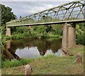
Upper Arley Footbridge
Wyre Forest DY12 1XB, United Kingdom

Upper Arley Footbridge
is a village
on the River Severn (upper river) between
Bewdley Bridge (3 miles and 6½ furlongs
to the southeast) and
Arley Quarry Landing (1 mile and 4 furlongs
to the northwest).
The nearest place in the direction of Bewdley Bridge is Severn Valley Railway Bridge (Arley);
5 furlongs
away.
There may be access to the towpath here.
Mooring here is unrated.
There is a bridge here which takes pedestrian traffic over the canal.
Limit of Navigation | 6 miles, 6¾ furlongs | |
A456 Bridge | 4 miles, 5 furlongs | |
Bewdley Bridge | 3 miles, 6½ furlongs | |
Northwood Lane Bridge | 1 mile, 6¾ furlongs | |
Severn Valley Railway Bridge (Arley) | 5 furlongs | |
Upper Arley Footbridge | ||
Arley Quarry Landing | 1 mile, 4 furlongs |
There are no links to external websites from here.
Why not log in and add some (select "External websites" from the menu (sometimes this is under "Edit"))?
Mouseover for more information or show routes to facility
Nearest water point
In the direction of Limit of Navigation
Lincomb Lock — 8 miles, 7½ furlongs away
Travel to Limit of Navigation, then on the River Severn (main river - Stourport to Worcester) to Lincomb Lock
Upper Basin Waterpoint — 7 miles, 6¾ furlongs and 2 locks away
Travel to Limit of Navigation, then on the River Severn (main river - Stourport to Worcester) to Severn - Stourport Broad Locks Entrance, then on the Staffordshire and Worcestershire Canal (Stourport Basins: Broad Route) to Stourport Upper Basin, then on the Staffordshire and Worcestershire Canal (Stourport Basins: Narrow Route) to Upper Basin Waterpoint
Holt Lock (Holt Fleet) — 13 miles, 1 furlong and 1 lock away
Travel to Limit of Navigation, then on the River Severn (main river - Stourport to Worcester) to Holt Lock (Holt Fleet)
Caldwall Mill Bridge No 14 — 11 miles, 5 furlongs and 5 locks away
Travel to Limit of Navigation, then on the River Severn (main river - Stourport to Worcester) to Severn - Stourport Broad Locks Entrance, then on the Staffordshire and Worcestershire Canal (Stourport Basins: Broad Route) to Stourport Upper Basin, then on the Staffordshire and Worcestershire Canal (Stourport Basins: Narrow Route) to York Street Bridge, then on the Staffordshire and Worcestershire Canal (Main Line: Stourport to Stourton) to Caldwall Mill Bridge No 14
Worcester Trip Boat Moorings — 19 miles, 6 furlongs and 3 locks away
Travel to Limit of Navigation, then on the River Severn (main river - Stourport to Worcester) to Worcester Trip Boat Moorings
Kinver Services — 18 miles, 4 furlongs and 11 locks away
Travel to Limit of Navigation, then on the River Severn (main river - Stourport to Worcester) to Severn - Stourport Broad Locks Entrance, then on the Staffordshire and Worcestershire Canal (Stourport Basins: Broad Route) to Stourport Upper Basin, then on the Staffordshire and Worcestershire Canal (Stourport Basins: Narrow Route) to York Street Bridge, then on the Staffordshire and Worcestershire Canal (Main Line: Stourport to Stourton) to Kinver Services
Stewponey Water Point — 19 miles, 7¾ furlongs and 13 locks away
Travel to Limit of Navigation, then on the River Severn (main river - Stourport to Worcester) to Severn - Stourport Broad Locks Entrance, then on the Staffordshire and Worcestershire Canal (Stourport Basins: Broad Route) to Stourport Upper Basin, then on the Staffordshire and Worcestershire Canal (Stourport Basins: Narrow Route) to York Street Bridge, then on the Staffordshire and Worcestershire Canal (Main Line: Stourport to Stourton) to Stewponey Water PointNearest rubbish disposal
In the direction of Limit of Navigation
Upper Basin Waterpoint — 7 miles, 6¾ furlongs and 2 locks away
Travel to Limit of Navigation, then on the River Severn (main river - Stourport to Worcester) to Severn - Stourport Broad Locks Entrance, then on the Staffordshire and Worcestershire Canal (Stourport Basins: Broad Route) to Stourport Upper Basin, then on the Staffordshire and Worcestershire Canal (Stourport Basins: Narrow Route) to Upper Basin Waterpoint
Sabrina Footbridge — 19 miles, 4 furlongs and 3 locks away
Travel to Limit of Navigation, then on the River Severn (main river - Stourport to Worcester) to Sabrina Footbridge
Kinver Services — 18 miles, 4 furlongs and 11 locks away
Travel to Limit of Navigation, then on the River Severn (main river - Stourport to Worcester) to Severn - Stourport Broad Locks Entrance, then on the Staffordshire and Worcestershire Canal (Stourport Basins: Broad Route) to Stourport Upper Basin, then on the Staffordshire and Worcestershire Canal (Stourport Basins: Narrow Route) to York Street Bridge, then on the Staffordshire and Worcestershire Canal (Main Line: Stourport to Stourton) to Kinver ServicesNearest chemical toilet disposal
In the direction of Limit of Navigation
Stourport Marina — 8 miles, 4 furlongs away
Travel to Limit of Navigation, then on the River Severn (main river - Stourport to Worcester) to Stourport Marina
Upper Basin Waterpoint — 7 miles, 6¾ furlongs and 2 locks away
Travel to Limit of Navigation, then on the River Severn (main river - Stourport to Worcester) to Severn - Stourport Broad Locks Entrance, then on the Staffordshire and Worcestershire Canal (Stourport Basins: Broad Route) to Stourport Upper Basin, then on the Staffordshire and Worcestershire Canal (Stourport Basins: Narrow Route) to Upper Basin Waterpoint
Caldwall Mill Bridge No 14 — 11 miles, 5 furlongs and 5 locks away
Travel to Limit of Navigation, then on the River Severn (main river - Stourport to Worcester) to Severn - Stourport Broad Locks Entrance, then on the Staffordshire and Worcestershire Canal (Stourport Basins: Broad Route) to Stourport Upper Basin, then on the Staffordshire and Worcestershire Canal (Stourport Basins: Narrow Route) to York Street Bridge, then on the Staffordshire and Worcestershire Canal (Main Line: Stourport to Stourton) to Caldwall Mill Bridge No 14
Kinver Services — 18 miles, 4 furlongs and 11 locks away
Travel to Limit of Navigation, then on the River Severn (main river - Stourport to Worcester) to Severn - Stourport Broad Locks Entrance, then on the Staffordshire and Worcestershire Canal (Stourport Basins: Broad Route) to Stourport Upper Basin, then on the Staffordshire and Worcestershire Canal (Stourport Basins: Narrow Route) to York Street Bridge, then on the Staffordshire and Worcestershire Canal (Main Line: Stourport to Stourton) to Kinver ServicesNearest place to turn
In the direction of Limit of Navigation
Severn - Stourport Narrow Locks Entrance — 7 miles, 4¾ furlongs away
Travel to Limit of Navigation, then on the River Severn (main river - Stourport to Worcester) to Severn - Stourport Narrow Locks Entrance
Stourport Lower Basin - between Broad Locks — 7 miles, 5¾ furlongs and 1 lock away
Travel to Limit of Navigation, then on the River Severn (main river - Stourport to Worcester) to Severn - Stourport Broad Locks Entrance, then on the Staffordshire and Worcestershire Canal (Stourport Basins: Broad Route) to Stourport Lower Basin - between Broad Locks
Stourport Lower Basin - between Narrow Locks — 7 miles, 6¼ furlongs and 1 lock away
Travel to Limit of Navigation, then on the River Severn (main river - Stourport to Worcester) to Severn - Stourport Broad Locks Entrance, then on the Staffordshire and Worcestershire Canal (Stourport Basins: Broad Route) to Stourport Lower Basin - between Broad Locks, then on the Staffordshire and Worcestershire Canal (Stourport Basins: Broad Locks to Narrow Locks to Stourport Lower Basin - between Narrow Locks
Stourport Upper Basin — 7 miles, 6½ furlongs and 2 locks away
Travel to Limit of Navigation, then on the River Severn (main river - Stourport to Worcester) to Severn - Stourport Broad Locks Entrance, then on the Staffordshire and Worcestershire Canal (Stourport Basins: Broad Route) to Stourport Upper Basin
Stourport Clock Basin — 7 miles, 7 furlongs and 2 locks away
Travel to Limit of Navigation, then on the River Severn (main river - Stourport to Worcester) to Severn - Stourport Broad Locks Entrance, then on the Staffordshire and Worcestershire Canal (Stourport Basins: Broad Route) to Stourport Upper Basin, then on the Staffordshire and Worcestershire Canal (Stourport Basins: Narrow Route) to Stourport Clock Basin
Former Railway Interchange Basin — 8 miles, 5 furlongs and 3 locks away
Travel to Limit of Navigation, then on the River Severn (main river - Stourport to Worcester) to Severn - Stourport Broad Locks Entrance, then on the Staffordshire and Worcestershire Canal (Stourport Basins: Broad Route) to Stourport Upper Basin, then on the Staffordshire and Worcestershire Canal (Stourport Basins: Narrow Route) to York Street Bridge, then on the Staffordshire and Worcestershire Canal (Main Line: Stourport to Stourton) to Former Railway Interchange Basin
Pratt's Wharf — 10 miles, ½ furlongs and 3 locks away
Travel to Limit of Navigation, then on the River Severn (main river - Stourport to Worcester) to Severn - Stourport Broad Locks Entrance, then on the Staffordshire and Worcestershire Canal (Stourport Basins: Broad Route) to Stourport Upper Basin, then on the Staffordshire and Worcestershire Canal (Stourport Basins: Narrow Route) to York Street Bridge, then on the Staffordshire and Worcestershire Canal (Main Line: Stourport to Stourton) to Pratt's Wharf
Holt Lock Weir Entrance — 12 miles, 6¾ furlongs and 1 lock away
Travel to Limit of Navigation, then on the River Severn (main river - Stourport to Worcester) to Holt Lock Weir Entrance
Holt Lock Weir Exit — 13 miles, 2 furlongs and 2 locks away
Travel to Limit of Navigation, then on the River Severn (main river - Stourport to Worcester) to Holt Lock Weir Exit
Academy Winding Hole — 11 miles, 7¼ furlongs and 5 locks away
Travel to Limit of Navigation, then on the River Severn (main river - Stourport to Worcester) to Severn - Stourport Broad Locks Entrance, then on the Staffordshire and Worcestershire Canal (Stourport Basins: Broad Route) to Stourport Upper Basin, then on the Staffordshire and Worcestershire Canal (Stourport Basins: Narrow Route) to York Street Bridge, then on the Staffordshire and Worcestershire Canal (Main Line: Stourport to Stourton) to Academy Winding Hole
Kidderminster — 12 miles, 1½ furlongs and 6 locks away
Travel to Limit of Navigation, then on the River Severn (main river - Stourport to Worcester) to Severn - Stourport Broad Locks Entrance, then on the Staffordshire and Worcestershire Canal (Stourport Basins: Broad Route) to Stourport Upper Basin, then on the Staffordshire and Worcestershire Canal (Stourport Basins: Narrow Route) to York Street Bridge, then on the Staffordshire and Worcestershire Canal (Main Line: Stourport to Stourton) to Kidderminster
Bevere Lock Weir Entrance — 16 miles, 3 furlongs and 2 locks away
Travel to Limit of Navigation, then on the River Severn (main river - Stourport to Worcester) to Bevere Lock Weir Entrance
Broadwaters Aqueduct Winding Hole — 12 miles, 7¾ furlongs and 6 locks away
Travel to Limit of Navigation, then on the River Severn (main river - Stourport to Worcester) to Severn - Stourport Broad Locks Entrance, then on the Staffordshire and Worcestershire Canal (Stourport Basins: Broad Route) to Stourport Upper Basin, then on the Staffordshire and Worcestershire Canal (Stourport Basins: Narrow Route) to York Street Bridge, then on the Staffordshire and Worcestershire Canal (Main Line: Stourport to Stourton) to Broadwaters Aqueduct Winding Hole
Bevere Lock Weir Exit — 16 miles, 5½ furlongs and 3 locks away
Travel to Limit of Navigation, then on the River Severn (main river - Stourport to Worcester) to Bevere Lock Weir Exit
Lea Lane Winding Hole — 14 miles, 3¾ furlongs and 8 locks away
Travel to Limit of Navigation, then on the River Severn (main river - Stourport to Worcester) to Severn - Stourport Broad Locks Entrance, then on the Staffordshire and Worcestershire Canal (Stourport Basins: Broad Route) to Stourport Upper Basin, then on the Staffordshire and Worcestershire Canal (Stourport Basins: Narrow Route) to York Street Bridge, then on the Staffordshire and Worcestershire Canal (Main Line: Stourport to Stourton) to Lea Lane Winding Hole
Debdale Lock Winding Hole — 15 miles, 1 furlong and 9 locks away
Travel to Limit of Navigation, then on the River Severn (main river - Stourport to Worcester) to Severn - Stourport Broad Locks Entrance, then on the Staffordshire and Worcestershire Canal (Stourport Basins: Broad Route) to Stourport Upper Basin, then on the Staffordshire and Worcestershire Canal (Stourport Basins: Narrow Route) to York Street Bridge, then on the Staffordshire and Worcestershire Canal (Main Line: Stourport to Stourton) to Debdale Lock Winding Hole
Cookley Forge Towpath Bridge — 15 miles, 2 furlongs and 9 locks away
Travel to Limit of Navigation, then on the River Severn (main river - Stourport to Worcester) to Severn - Stourport Broad Locks Entrance, then on the Staffordshire and Worcestershire Canal (Stourport Basins: Broad Route) to Stourport Upper Basin, then on the Staffordshire and Worcestershire Canal (Stourport Basins: Narrow Route) to York Street Bridge, then on the Staffordshire and Worcestershire Canal (Main Line: Stourport to Stourton) to Cookley Forge Towpath Bridge
Whittington Winding Hole — 17 miles, 5¼ furlongs and 10 locks away
Travel to Limit of Navigation, then on the River Severn (main river - Stourport to Worcester) to Severn - Stourport Broad Locks Entrance, then on the Staffordshire and Worcestershire Canal (Stourport Basins: Broad Route) to Stourport Upper Basin, then on the Staffordshire and Worcestershire Canal (Stourport Basins: Narrow Route) to York Street Bridge, then on the Staffordshire and Worcestershire Canal (Main Line: Stourport to Stourton) to Whittington Winding Hole
Ladywood Top Lock Winding Hole — 18 miles, 6½ furlongs and 10 locks away
Travel to Limit of Navigation, then on the River Severn (main river - Stourport to Worcester) to Hawford Junction, then on the Droitwich Canals (Droitwich Barge Canal) to Ladywood Top Lock Winding Hole
Hyde Lock Winding Hole — 18 miles, 7¼ furlongs and 12 locks away
Travel to Limit of Navigation, then on the River Severn (main river - Stourport to Worcester) to Severn - Stourport Broad Locks Entrance, then on the Staffordshire and Worcestershire Canal (Stourport Basins: Broad Route) to Stourport Upper Basin, then on the Staffordshire and Worcestershire Canal (Stourport Basins: Narrow Route) to York Street Bridge, then on the Staffordshire and Worcestershire Canal (Main Line: Stourport to Stourton) to Hyde Lock Winding HoleNearest self-operated pump-out
In the direction of Limit of Navigation
Kinver Services — 18 miles, 4 furlongs and 11 locks away
Travel to Limit of Navigation, then on the River Severn (main river - Stourport to Worcester) to Severn - Stourport Broad Locks Entrance, then on the Staffordshire and Worcestershire Canal (Stourport Basins: Broad Route) to Stourport Upper Basin, then on the Staffordshire and Worcestershire Canal (Stourport Basins: Narrow Route) to York Street Bridge, then on the Staffordshire and Worcestershire Canal (Main Line: Stourport to Stourton) to Kinver ServicesNearest boatyard pump-out
In the direction of Limit of Navigation
Stourport Marina — 8 miles, 4 furlongs away
Travel to Limit of Navigation, then on the River Severn (main river - Stourport to Worcester) to Stourport Marina
Stourport Upper Basin — 7 miles, 6½ furlongs and 2 locks away
Travel to Limit of Navigation, then on the River Severn (main river - Stourport to Worcester) to Severn - Stourport Broad Locks Entrance, then on the Staffordshire and Worcestershire Canal (Stourport Basins: Broad Route) to Stourport Upper Basin
Upper Staircase Lock Landing Pontoon — 7 miles, 7¼ furlongs and 2 locks away
Travel to Limit of Navigation, then on the River Severn (main river - Stourport to Worcester) to Severn - Stourport Broad Locks Entrance, then on the Staffordshire and Worcestershire Canal (Stourport Basins: Broad Route) to Stourport Upper Basin, then on the Staffordshire and Worcestershire Canal (Stourport Basins: Narrow Route) to Upper Staircase Lock Landing PontoonDirection of TV transmitter (From Wolfbane Cybernetic)
There is no page on Wikipedia called “Upper Arley Footbridge”
Wikipedia pages that might relate to Upper Arley Footbridge
[Upper Arley]
parish by a foot ferry, which was replaced in 1972 by a footbridge. The manor of Upper Arley had various owners before 1276, when it was bought by Roger
[Arley railway station]
Worcestershire, situated just over the River Severn from the village of Upper Arley; a footbridge crosses the river to link the station to the village. The station
[River Severn]
villages of Quatford and Hampton Loade and the Worcestershire village of Upper Arley follow, before the Severn runs through Bewdley and Stourport-on-Severn
[River Avon, Warwickshire]
traditionally been divided since 1719 into the Lower Avon, below Evesham, and the Upper Avon, from Evesham to above Stratford-upon-Avon. Improvements to aid navigation
[List of crossings of the River Severn]
2017. "It's all systems go for July official opening as new cycle and footbridge gradually takes shape (From Worcester News)". Worcester News. Newsquest
[Wolverhampton]
monastery was consecrated in Wolverhampton for which Wulfrun granted land at Upper Arley in Worcestershire, Bilston, Willenhall, Wednesfield, Pelsall, Ogley Hay
[Sir John Fowler, 1st Baronet]
London Railway. He is credited with the design of the Victoria Bridge at Upper Arley, Worcestershire, constructed between 1859 and 1861, and the near identical
[Cotswold Line]
three new platforms at Charlbury, Ascott-under-Wychwood and Honeybourne. Footbridges at Charlbury and Honeybourne as well as preparation for the upgrade of
[Droitwich Canal]
dredged 73,000 tons of mud from the Droitwich Canals in 1881, and altered the upper cills of the locks in 1888-9, to give a navigable depth of 6 feet (1.8 m)
[List of non-ecclesiastical and non-residential works by John Douglas]
were William Molyneux, 4th Earl of Sefton, Rowland Egerton-Warburton of Arley Hall, George Cholmondeley, 5th Marquess of Cholmondeley, and Francis Egerton
Results of Google Search
Arley railway station - WikipediaArley railway station is a station on the Severn Valley Railway heritage line in Worcestershire, situated just over the River Severn from the village of Upper Arley; a footbridge crosses the river to link the station to the village.
Aug 3, 2008 ... Upper Arley Footbridge is a pedestrian bridge (footbridge), warren type truss bridge, through truss bridge and steel bridge that was completed ...
Upper Arley (grid reference SO765805) is a village and civil parish near Kidderminster in the ... at the entrance to the manor house of Arley House, as does one by the footbridge across the River Severn in the village; and the estate buildings, ...
Oct 9, 2011 ... Media in category "Upper Arley footbridge". The following 9 files are in this category, out of 9 total. Cropped image of footbridge at Upper Arley ...
This is a list of crossings of the River Severn in Great Britain in order from source to mouth. ... Footbridge at the meeting of the Severn Way and the Wye Valley Walk - geograph. ...... 52.41820; -2.34578#xfeff; (Arley footbridge), -, Upper Arley, Truss footbridge, replaced a vehicular ferry, River Severn,Upper Arley footbridge.jpg.
Jul 2, 2018 ... Cropped_image_of_footbridge_at_Upper_Arley_-_geograph_org_uk_-_ 1544619.jpg (399 × 295 pixels, file size: 28 KB, MIME type: ...
Upper Arley Conservation Area: Character Appraisal November 2007. 1. 1. INTRODUCTION ... the River are connected via a footbridge. On the opposite side of ...
Jul 2, 2018 ... Original file (2,288 × 1,712 pixels, file size: 819 KB, MIME type: image/jpeg). File information. Structured data ...
The Parish itself is made up of three small villages - Upper Arley itself, Pound Green and ... Arley lies on the banks of the river, and welcomes large numbers of visitors, ... Arley Arboretum · Arley Arboretum · River Severn from Arley Footbridge ...
Upper Arley Conservation Area was designated in 1991 and is based upon a rural hamlet set on the ... A footbridge links the north and south banks of the River .