CanalPlanAC

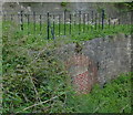
Norwood Tunnel (eastern entrance)

 
Limit of Navigation
Pennyholme Close, Rotherham S26 6PT, United Kingdom
 
Information about the place
Norwood Tunnel (eastern entrance) is a major waterways place at the junction of the Chesterfield Canal (Norwood to Retford) with the Chesterfield Canal (Unnavigable section).
 
Manor Road Winding Hole (Feeder from Harthill Reservoir enters at winding hole) is on the Chesterfield Canal (Norwood to Retford), 2¾ furlongs to the east. Nethermoor Lake Marina is on the Chesterfield Canal (Unnavigable section), 3 miles and 32 locks to the west.
 
It is at one end of Norwood Tunnel.
 
The nearest place in the direction of Nethermoor Lake Marina is Hard Lane Box Culvert No 30I (Connects to the existing Norwood Tunnel to make a new Western Portal); 2½ furlongs away.

Mooring here is excellent (this is a really good mooring), mooring rings or bollards are available. One needs to reverse from the winding hole, 4 capstons on the offside.


Amenities
 
Maps
If you are a user and are logged on, or if you are actively planning a route, a map will be displayed here.
Show on external mapping site: Google | OSM | Bing
 
Photos
 
External websites
There are no links to external websites from here.
Why not log in and add some (select "External websites" from the menu (sometimes this is under "Edit"))?
 
Nearest facilities

Mouseover for more information or show routes to facility

Nearest water point

In the direction of West Retford Lock No 58

Shireoaks Marina3 miles, 7 furlongs and 23 locks away
On the Chesterfield Canal (Norwood to Retford) in the direction of West Retford Lock No 58
Forest Middle Top Water Point13 miles, 2¾ furlongs and 36 locks away
On the Chesterfield Canal (Norwood to Retford) in the direction of West Retford Lock No 58
Forest Middle Top Lock No 5513 miles, 3 furlongs and 36 locks away
On the Chesterfield Canal (Norwood to Retford) in the direction of West Retford Lock No 58
Hop Pole Bridge No 5917 miles, 4¾ furlongs and 41 locks away
Travel to West Retford Lock No 58, then on the Chesterfield Canal (Retford to the Trent) to Hop Pole Bridge No 59

Nearest rubbish disposal

In the direction of West Retford Lock No 58

Shireoaks Marina3 miles, 7 furlongs and 23 locks away
On the Chesterfield Canal (Norwood to Retford) in the direction of West Retford Lock No 58
Forest Middle Top Lock No 5513 miles, 3 furlongs and 36 locks away
On the Chesterfield Canal (Norwood to Retford) in the direction of West Retford Lock No 58

Nearest chemical toilet disposal

In the direction of West Retford Lock No 58

Shireoaks Marina3 miles, 7 furlongs and 23 locks away
On the Chesterfield Canal (Norwood to Retford) in the direction of West Retford Lock No 58
Cuckoo Wharf Elsan6 miles, 1 furlong and 32 locks away
On the Chesterfield Canal (Norwood to Retford) in the direction of West Retford Lock No 58
Forest Middle Top Lock No 5513 miles, 3 furlongs and 36 locks away
On the Chesterfield Canal (Norwood to Retford) in the direction of West Retford Lock No 58

Nearest place to turn

In the direction of West Retford Lock No 58

Manor Road Winding Hole2¾ furlongs away
On the Chesterfield Canal (Norwood to Retford) in the direction of West Retford Lock No 58
Little Lane Bridge Winding Hole2 miles, 7½ furlongs and 15 locks away
On the Chesterfield Canal (Norwood to Retford) in the direction of West Retford Lock No 58
Shireoaks Marina3 miles, 7 furlongs and 23 locks away
On the Chesterfield Canal (Norwood to Retford) in the direction of West Retford Lock No 58
Junction with former Lady Lee Arm5 miles, 1¾ furlongs and 30 locks away
On the Chesterfield Canal (Norwood to Retford) in the direction of West Retford Lock No 58
Morse Lock Winding Hole5 miles, 6 furlongs and 31 locks away
On the Chesterfield Canal (Norwood to Retford) in the direction of West Retford Lock No 58
High Hoe Road Bridge Winding Hole6 miles, 6¼ furlongs and 33 locks away
On the Chesterfield Canal (Norwood to Retford) in the direction of West Retford Lock No 58
Ranby Bridge Winding Hole10 miles, 6¼ furlongs and 35 locks away
On the Chesterfield Canal (Norwood to Retford) in the direction of West Retford Lock No 58
Forest Top Lock Winding Hole13 miles and 36 locks away
On the Chesterfield Canal (Norwood to Retford) in the direction of West Retford Lock No 58
Babworth Winding Hole15 miles, ½ furlongs and 39 locks away
On the Chesterfield Canal (Norwood to Retford) in the direction of West Retford Lock No 58
Retford Winding Hole16 miles, 4¾ furlongs and 41 locks away
Travel to West Retford Lock No 58, then on the Chesterfield Canal (Retford to the Trent) to Retford Winding Hole
Grove Mill Bridge Winding Hole16 miles, 6½ furlongs and 41 locks away
Travel to West Retford Lock No 58, then on the Chesterfield Canal (Retford to the Trent) to Grove Mill Bridge Winding Hole

In the direction of Staveley Town Basin

Kiveton Waters Marina4 furlongs and 3 locks away
On the Chesterfield Canal (Unnavigable section) in the direction of Staveley Town Basin
Norwood Winding Hole2 miles and 26 locks away
On the Chesterfield Canal (Unnavigable section) in the direction of Staveley Town Basin
Hartington Harbour7 miles, 7½ furlongs and 41 locks away
Travel to Nethermoor Lake Marina, then on the Chesterfield Canal (Central Line West) to New Leah’s Bridge No 26B, then on the Chesterfield Canal (Unnavigable section) to Hartington Harbour
Staveley Town Basin8 miles, ¾ furlongs and 42 locks away
Travel to Nethermoor Lake Marina, then on the Chesterfield Canal (Central Line West) to New Leah’s Bridge No 26B, then on the Chesterfield Canal (Unnavigable section) to Staveley Town Basin
Works Road Winding Hole9 miles, 4¼ furlongs and 42 locks away
Travel to Nethermoor Lake Marina, then on the Chesterfield Canal (Central Line West) to New Leah’s Bridge No 26B, then on the Chesterfield Canal (Unnavigable section) to Staveley Town Basin, then on the Chesterfield Canal (Derbyshire restored section) to Works Road Winding Hole
Bilby Lane Bridge Winding Hole10 miles, 5½ furlongs and 44 locks away
Travel to Nethermoor Lake Marina, then on the Chesterfield Canal (Central Line West) to New Leah’s Bridge No 26B, then on the Chesterfield Canal (Unnavigable section) to Staveley Town Basin, then on the Chesterfield Canal (Derbyshire restored section) to Bilby Lane Bridge Winding Hole

No information

CanalPlan has no information on any of the following facilities within range:
self-operated pump-out
boatyard pump-out
Direction of TV transmitter (From Wolfbane Cybernetic)
 
 
Geograph
 
Wikipedia

Wikipedia has a page about Norwood Tunnel

Norwood Tunnel was a 2,884-yard-long (2,637 m), 9.25-foot-wide (2.82 m) and 12-foot-high (3.7 m) brick (3 million of them) lined canal tunnel on the line of the Chesterfield Canal with its Western Portal in Norwood, Derbyshire and its Eastern Portal in Kiveton, South Yorkshire, England.

Other Wikipedia pages that might relate to Norwood Tunnel
[Harecastle Tunnel] in 1772, the first tunnel - which measured 2,880 yd (2,630 m) long – was completed in 1777. On opening, it overtook Norwood Tunnel on the Chesterfield [Chesterfield Canal] Chesterfield, Derbyshire, passing through the Norwood Tunnel at Kiveton Park, at the time one of the longest tunnels on the British canal system. The canal was [Standedge Tunnels] sub-committee visited Harecastle Tunnel on the Trent and Mersey Canal, Butterley Tunnel on the Cromford Canal and the Norwood Tunnel on the Chesterfield Canal [Legging (canals)] tunnel Islington Tunnel Lapal Tunnel Maida Hill Tunnel Morwell Down Tunnel Norwood Tunnel Sapperton Canal Tunnel Standedge Tunnel Worsley Navigable Levels [List of tunnels in the United Kingdom] This is a list of road, railway, waterway, and other tunnels in the United Kingdom. A tunnel is an underground passageway with no defined minimum length [List of canal tunnels in the United Kingdom] Hyde Bank Tunnel Woodley Tunnel Islington Tunnel Lisson Grove Tunnel Maida Hill Tunnel Falkirk Tunnel, Falkirk Roughcastle Tunnel, Falkirk. Part of the Falkirk [Killamarsh] through the town on its way to Kiveton via the Norwood Tunnel, which was the joint longest canal tunnel in the UK at the time of its construction. The [John Varley (canal engineer)] two tunnels: a short 154 yards (141 m) tunnel near Gringley Beacon, and the major 2,880 yard long Norwood Tunnel. At the time of construction, Norwood Tunnel [West Norwood] West Norwood is a largely residential area of south London within the London Borough of Lambeth, located 5.4 miles (8.7 km) south south-east of Charing
 
Google

Results of Google Search

Norwood Tunnel - Wikipedia
Norwood Tunnel was a 2,884-yard-long (2,637 m), 9.25-foot-wide (2.82 m) and 12-foot-high (3.7 m) brick (3 million of them) lined canal tunnel on the line of the Chesterfield Canal with its Western Portal in Norwood, Derbyshire and its Eastern Portal in ... Skempton, in his entry for John Varley, quotes the length as 2,884 yards ...
Going over the top. - NB Holderness
Apr 28, 2014 ... The eastern entrance of the Norwood Tunnel. It is in water right up to the entrance. James Brindley had several thoughts about the tunnel, ...
To Stop Violence at Oval Park, Locals Propose Locking it Up ...
Sep 21, 2017 ... 30, in the park's tunnel entrance by Van Cortlandt Avenue East and Reservoir ... particularly in the tunnel at the Reservoir Oval East entrance, would help ... You can send e-mails to norwoodnews@norwoodnews.org or call us ...
Norwood Lateral Expressway
tunnel existed until early 2004 east of Montgomery Rd., running parallel to but out of sight of the expressway. The tunnel's newly sealed east portal can be seen ...
Getting Around BIDMC | BIDMC of Boston
The east and west campuses of Beth Israel Deaconess Medical Center are ... Feldberg Building entrance on the East Campus at 330 Brookline Avenue; Lowry  ...
Maps and Directions | Newton-Wellesley Hospital
Proceed on Route 16 East 0.25 mile to the Hospital's East Entrance (second entrance). Valet parking is also available. From Boston. Take the Mass Pike to Exit 16 ...
Hoosac Tunnel – North Adams, Massachusetts - Atlas Obscura
The East tunnel entrance (East Portal) at the intersection of Whitcomb Hill Road and River Road in Florida, take River Road northwest about half a mile until it ...