Ash Aqueduct
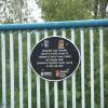
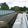
New aqueduct (92yds) created to allow the A331 to pass below the canal. A set of narrows are constructed either side of the aqueduct. Access to Spring Lakes from here
Basingstoke Canal Towpath, Ash GU12 4UZ, United Kingdom

Ash Aqueduct
is a minor waterways place
on the Basingstoke Canal between
Woodham Junction (Junction of Basingstoke Canal with River Wey) (15 miles and 6¾ furlongs
and 28 locks
to the east) and
Odiham Castle Stop (End of Navigation) (14 miles and 6¼ furlongs
and 1 lock
to the west).
The nearest place in the direction of Woodham Junction is Ash Vale Railway Bridge;
3 furlongs
away.
The nearest place in the direction of Odiham Castle Stop is Aldershot Railway Bridge;
3 furlongs
away.
There may be access to the towpath here.
Mooring here is unrated.
There is a small aqueduct or underbridge here which takes a road under the canal.
Great Bottom Flash | 1 mile, 4½ furlongs | |
Heath Vale Bridge | 1 mile, 1½ furlongs | |
Ash Wharf Bridge Winding Hole | 3¾ furlongs | |
Ash Wharf Bridge | 3¾ furlongs | |
Ash Vale Railway Bridge | 3 furlongs | |
Ash Aqueduct | ||
Aldershot Railway Bridge | 3 furlongs | |
Government Road Bridge | 4¼ furlongs | |
Ash Lock No 29 | 4¼ furlongs | |
Ash Lock Canal Depot | 4½ furlongs | |
Mons Barracks Footbridge | 1 mile, ¾ furlongs |
Amenities here
Amenities nearby at Ash Vale Railway Bridge
Amenities nearby at Aldershot Railway Bridge
There are no links to external websites from here.
Why not log in and add some (select "External websites" from the menu (sometimes this is under "Edit"))?
Mouseover for more information or show routes to facility
Nearest water point
In the direction of Odiham Castle Stop
Ash Lock Canal Depot — 4½ furlongs and 1 lock away
On this waterway in the direction of Odiham Castle Stop
The Fox and Hounds (Crookham) — 6 miles, 2¾ furlongs and 1 lock away
On this waterway in the direction of Odiham Castle Stop
Barley Mow Bridge — 10 miles, 3¾ furlongs and 1 lock away
On this waterway in the direction of Odiham Castle Stop
In the direction of Woodham Junction
Mytchett Bridge — 2 miles, 6 furlongs away
On this waterway in the direction of Woodham Junction
Canal Centre Swing Bridge — 2 miles, 7 furlongs away
On this waterway in the direction of Woodham Junction
Arthur's Bridge — 11 miles, 1¼ furlongs and 22 locks away
On this waterway in the direction of Woodham Junction
Pyrford Lock No 12 — 17 miles, 6¼ furlongs and 28 locks away
Travel to Woodham Junction, then on the River Wey Wey Navigation to Pyrford Lock No 12
Thames Lock No 16 — 18 miles, 4¼ furlongs and 31 locks away
Travel to Woodham Junction, then on the River Wey Wey Navigation to Thames Lock No 16Nearest rubbish disposal
In the direction of Odiham Castle Stop
Ash Lock Canal Depot — 4½ furlongs and 1 lock away
On this waterway in the direction of Odiham Castle Stop
In the direction of Woodham Junction
Mytchett Bridge — 2 miles, 6 furlongs away
On this waterway in the direction of Woodham Junction
Canal Centre Swing Bridge — 2 miles, 7 furlongs away
On this waterway in the direction of Woodham Junction
Arthur's Bridge — 11 miles, 1¼ furlongs and 22 locks away
On this waterway in the direction of Woodham Junction
Pyrford Lock No 12 — 17 miles, 6¼ furlongs and 28 locks away
Travel to Woodham Junction, then on the River Wey Wey Navigation to Pyrford Lock No 12
Shepperton Lock — 18 miles, 7½ furlongs and 32 locks away
Travel to Woodham Junction, then on the River Wey Wey Navigation to Thames - Wey Junction, then on the River Thames (below Oxford) to Shepperton LockNearest chemical toilet disposal
In the direction of Woodham Junction
Canal Centre Swing Bridge — 2 miles, 7 furlongs away
On this waterway in the direction of Woodham Junction
Arthur's Bridge — 11 miles, 1¼ furlongs and 22 locks away
On this waterway in the direction of Woodham Junction
Pyrford Lock No 12 — 17 miles, 6¼ furlongs and 28 locks away
Travel to Woodham Junction, then on the River Wey Wey Navigation to Pyrford Lock No 12
Shepperton Lock — 18 miles, 7½ furlongs and 32 locks away
Travel to Woodham Junction, then on the River Wey Wey Navigation to Thames - Wey Junction, then on the River Thames (below Oxford) to Shepperton LockNearest place to turn
In the direction of Odiham Castle Stop
Ash Lock Canal Depot — 4½ furlongs and 1 lock away
On this waterway in the direction of Odiham Castle Stop
Wharf Bridge (Aldershot) Winding Hole — 2 miles and 1 lock away
On this waterway in the direction of Odiham Castle Stop
Eelmoor Bridge Winding Hole — 3 miles, 3¼ furlongs and 1 lock away
On this waterway in the direction of Odiham Castle Stop
Pondtail Bridge Winding Hole — 4 miles, 6¼ furlongs and 1 lock away
On this waterway in the direction of Odiham Castle Stop
Crondall Bridge Winding Hole — 7 miles, 6 furlongs and 1 lock away
On this waterway in the direction of Odiham Castle Stop
Blacksmiths Bridge Winding Hole — 9 miles, 3¼ furlongs and 1 lock away
On this waterway in the direction of Odiham Castle Stop
Colt Hill Bridge Winding Hole — 13 miles, ¾ furlongs and 1 lock away
On this waterway in the direction of Odiham Castle Stop
Whitewater Winding Hole — 14 miles, 6 furlongs and 1 lock away
On this waterway in the direction of Odiham Castle Stop
In the direction of Woodham Junction
Ash Wharf Bridge Winding Hole — 3¾ furlongs away
On this waterway in the direction of Woodham Junction
Great Bottom Flash — 1 mile, 4½ furlongs away
On this waterway in the direction of Woodham Junction
Winter's Close Winding Hole — 1 mile, 7½ furlongs away
On this waterway in the direction of Woodham Junction
Anglers' Flash — 2 miles, ¾ furlongs away
On this waterway in the direction of Woodham Junction
Potter's Wharf — 2 miles, 5¼ furlongs away
On this waterway in the direction of Woodham Junction
Lock No 26 Winding Hole — 5 miles, 4 furlongs and 3 locks away
On this waterway in the direction of Woodham Junction
Frimley Lock Winding Hole — 6 miles, 3¼ furlongs and 9 locks away
On this waterway in the direction of Woodham Junction
Frimley Bottom Lock Winding Hole — 7 miles, 1¾ furlongs and 13 locks away
On this waterway in the direction of Woodham Junction
Connaught Crescent Winding Hole — 7 miles, 4½ furlongs and 14 locks away
On this waterway in the direction of Woodham Junction
Hermitage Bridge Winding Hole — 8 miles, 7¾ furlongs and 17 locks away
On this waterway in the direction of Woodham Junction
Blackhorse Road Winding Hole — 9 miles, 1 furlong and 17 locks away
On this waterway in the direction of Woodham Junction
Arthurs Bridge Winding Hole — 11 miles, 1½ furlongs and 22 locks away
On this waterway in the direction of Woodham JunctionNearest self-operated pump-out
In the direction of Woodham Junction
Mytchett Bridge — 2 miles, 6 furlongs away
On this waterway in the direction of Woodham Junction
Canal Centre Swing Bridge — 2 miles, 7 furlongs away
On this waterway in the direction of Woodham JunctionNo information
CanalPlan has no information on any of the following facilities within range:boatyard pump-out
Direction of TV transmitter (From Wolfbane Cybernetic)
There is no page on Wikipedia called “Ash Aqueduct”
Wikipedia pages that might relate to Ash Aqueduct
[River Blackwater (River Loddon)]
The Ash Aqueduct. Basingstoke Canal. November 2001. Archived from the original on 18 June 2020. "Introduction - an Overview". The Ash Aqueduct. Basingstoke
[Eifel Aqueduct]
The Eifel Aqueduct was one of the longest aqueducts of the Roman Empire. The aqueduct, constructed in AD 80, carried water some 95 kilometres (59 mi)
[Fly ash]
Fly ash or flue ash, also known as pulverised fuel ash in the United Kingdom, is a coal combustion product that is composed of the particulates (fine particles
[Basingstoke Canal]
and a lack of water. There were no locks on this part of the canal after Ash and so the route generally followed the contours of the land with occasional
[Pompeii]
6 m (13 to 20 ft) of volcanic ash and pumice in the eruption of Mount Vesuvius in AD 79. Largely preserved under the ash, the excavated city offered a
[Hanging Gardens of Babylon]
Gaugamela in 331 BC Alexander the Great camped for four days near the aqueduct at Jerwan. The historians who travelled with him would have had ample time
[Aqua Augusta (Naples)]
appear on this list. The next major eruption in 472 AD left the aqueduct covered in ash and 3.5 km of the duct collapsed because of this. This cut off
[Weston Aqueduct]
The Weston Aqueduct is an aqueduct operated by the Massachusetts Water Resources Authority (MWRA). Now part of the MWRA backup systems, it was designed
[Staines Reservoirs]
into the Staines Reservoirs Aqueduct which channelled the water to Staines. The aqueduct spilt over into the River Ash which over topped its banks and
[Ancient Roman engineering]
metres (260,000 US gal) of water were brought into Rome by 11 different aqueducts each day. Per capita water usage in ancient Rome matched that of modern-day
Results of Google Search
Basingstoke Canal repair - Ash Wharf to the A331 Aqueduct - 2016 ...Apr 9, 2017 ... Repaired in 2016, the banks were leaking into the fishing lakes which are at a much lower level. The section between Ash Wharf and the A331Â ...
... and Weston, including the following in Weston: Weston Aqueduct, Weston Reservoir, Ash Street Bridge, Weston Terminal Chamber, Weston Screen Chamber, ...
Oct 20, 2019 ... Thousands of motorists drive underneath the incredible Ash Aqueduct every day, yet not many people realise it is there.
Sep 1, 2018 ... Buy your EarthQuaker Devices Aqueduct Vibrato Guitar Effects Pedal from Sam Ash and receive the guaranteed lowest price. Enjoy our 45-day ...
Title: Weston Aqueduct, Section 14, Ash Street Bridge over Open Channel, Weston, Mass., Sep. 25, 1903; Sponsor: Massachusetts. Metropolitan Water and  ...
Apr 15, 2015 ... The Ash Aqueduct was built to allow the construction of the bypass road under it, and is cut into the original Ash Embankment.
Feb 3, 2009 ... The Ash Aqueduct II by Fred255. Renderosity - a digital art community for cg artists to buy and sell 2d and 3d content, cg news, free 3d models, ...
The initial proposal by Surrey County Council was for a series of six locks - three each side of the new road, to allow boats to navigate under the road which ...
May 27, 2019 ... In the ASH group, ASHw was defined as the worse hearing ear with profound ... dysplasia (39.8?and enlarged vestibular aqueduct (26.5?
On Saturday 29th of July 1995, one month after the aqueduct was completed and the canal re-opened, the Canal Society's 67ft trip boat 'John Pinkerton'Â ...