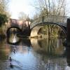
Northern End of Former Newbold Loop
A typical Horsley Iron Works bridge crosses the loop entrance numbered 45.
Rugby Road, Harborough Magna CV23 0HA, United Kingdom 

Northern End of Former Newbold Loop
is a minor waterways place
on the Oxford Canal (Northern Section - Main Line) between
  Newbold Wharf (4½ furlongs
   to the southeast) and
  Easenhall Lane Bridge No 34 (Brinklow, ¾ mile west) (2 miles and 7¾ furlongs
   to the west).
  The nearest place in the direction of Newbold Wharf is Falls Bridge No 48;
  ¼ furlongs
   away.
   
  The nearest place in the direction of Easenhall Lane Bridge No 34 is Falls Bridge Wharf (Armada Waterside & Boat Hire);
  ½ furlongs
   away.
Mooring here is tolerable (it's just about possible if really necessary).
You can wind here.
| The Barley Mow PH (Newbold)  | 4½ furlongs | |
| Newbold Wharf  | 4½ furlongs | |
| Newbold Tunnel (southern entrance) | 3¾ furlongs | |
| Newbold Tunnel (northern entrance) | 3 furlongs | |
| Falls Bridge No 48  | ¼ furlongs | |
| Northern End of Former Newbold Loop | ||
| Falls Bridge Wharf  | ½ furlongs | |
| Cathiron Lane Bridge No 44 | 1¼ furlongs | |
| Lime Farm Marina  | 3¼ furlongs | |
| Tuckey's Bridge No 43  | 5½ furlongs | |
| Cathiron Railway Bridge No 42A | 7 furlongs | |
The canal used to run across the fields and through a totally
different tunnel at Newbold.
If you walk through the church yard
at Newbold you can see the portal of the old tunnel and the original
line of the canal
- Oxford Canal Walk - Part One - Oxford to Thrupp - YouTube — associated with Oxford Canal
 - A walk along the Oxford Canal (Southern Section) from Oxford to Thrupp Wide
 
Mouseover for more information or show routes to facility
Nearest water point
In the direction of Hawkesbury Junction
Stretton Stop — 3 miles, 5½ furlongs  away
On this waterway in the direction of Hawkesbury Junction
Ansty Water Point — 7 miles, 1¾ furlongs  away
On this waterway in the direction of Hawkesbury Junction
Hawkesbury Water Point (stop lock) — 10 miles, 7 furlongs  away
On this waterway in the direction of Hawkesbury Junction
Hawkesbury Services — 10 miles, 7¾ furlongs  and 1 lock away
Travel  to Hawkesbury Junction, then on the Coventry Canal (Main Line - Coventry to Hawkesbury) to Hawkesbury Services
Hawkesbury Water Point (Engine House) — 11 miles, ¼ furlongs  and 1 lock away
Travel  to Hawkesbury Junction, then on the Coventry Canal (Main Line - Hawkesbury to Fazeley) to Hawkesbury Water Point (Engine House)
Coventry Visitor Moorings (outside basin) — 16 miles, 2¾ furlongs  and 1 lock away
Travel  to Hawkesbury Junction, then on the Coventry Canal (Main Line - Coventry to Hawkesbury) to Coventry Visitor Moorings (outside basin)
Coventry Basin Services — 16 miles, 3¼ furlongs  and 1 lock away
Travel  to Hawkesbury Junction, then on the Coventry Canal (Main Line - Coventry to Hawkesbury) to Coventry Basin Services
Springwood Haven Marina — 18 miles, 3½ furlongs  and 1 lock away
Travel  to Hawkesbury Junction, then on the Coventry Canal (Main Line - Hawkesbury to Fazeley) to Springwood Haven Marina
Limekiln Bridge No 15 — 18 miles, 6½ furlongs  and 1 lock away
Travel  to Hawkesbury Junction, then on the Coventry Canal (Main Line - Hawkesbury to Fazeley) to Marston Junction, then on the Ashby Canal (Main Line) to Limekiln Bridge No 15
C&RT Hartshill Maintenance Yard and Wharf — 19 miles, 6 furlongs  and 1 lock away
Travel  to Hawkesbury Junction, then on the Coventry Canal (Main Line - Hawkesbury to Fazeley) to C&RT Hartshill Maintenance Yard and Wharf
Trinity Marina — 19 miles, 6½ furlongs  and 1 lock away
Travel  to Hawkesbury Junction, then on the Coventry Canal (Main Line - Hawkesbury to Fazeley) to Marston Junction, then on the Ashby Canal (Main Line) to Trinity Marina
In the direction of Braunston Turn
Newbold Wharf — 4½ furlongs  away
On this waterway in the direction of Braunston Turn
Rugby Visitor Moorings — 2 miles, ¼ furlongs  away
On this waterway in the direction of Braunston Turn
Hillmorton Water Point — 4 miles, 3¾ furlongs  away
On this waterway in the direction of Braunston Turn
Dunchurch Pools Marina — 8 miles, 5¾ furlongs  and 3 locks away
On this waterway in the direction of Braunston Turn
Braunston Services — 11 miles, 6½ furlongs  and 3 locks away
On this waterway in the direction of Braunston Turn
Braunston Road Bridge No 91 — 12 miles, ¼ furlongs  and 3 locks away
Travel  to Braunston Turn, then on the Grand Union Canal (Grand Junction Canal - Main Line - Braunston to Norton) to Braunston Road Bridge No 91
Braunston Stop — 12 miles, 1¾ furlongs  and 3 locks away
Travel  to Braunston Turn, then on the Grand Union Canal (Grand Junction Canal - Main Line - Braunston to Norton) to Braunston Stop
Wigrams Turn Marina — 16 miles, 6¾ furlongs  and 3 locks away
Travel  to Braunston Turn, then on the Grand Union Canal (Oxford Canal Section) to Wigrams Turn Marina
Calcutt Top Lock Winding Hole — 17 miles, 3 furlongs  and 3 locks away
Travel  to Braunston Turn, then on the Grand Union Canal (Oxford Canal Section) to Napton Junction, then on the Grand Union Canal (Warwick and Napton Canal) to Calcutt Top Lock Winding HoleNearest rubbish disposal
In the direction of Hawkesbury Junction
Hawkesbury Services — 10 miles, 7¾ furlongs  and 1 lock away
Travel  to Hawkesbury Junction, then on the Coventry Canal (Main Line - Coventry to Hawkesbury) to Hawkesbury Services
Trinity Marina — 19 miles, 6½ furlongs  and 1 lock away
Travel  to Hawkesbury Junction, then on the Coventry Canal (Main Line - Hawkesbury to Fazeley) to Marston Junction, then on the Ashby Canal (Main Line) to Trinity Marina
In the direction of Braunston Turn
Newbold Wharf — 4½ furlongs  away
On this waterway in the direction of Braunston Turn
Hillmorton Bridge No 71 — 4 miles, 5¼ furlongs  and 1 lock away
On this waterway in the direction of Braunston Turn
Dunchurch Pools Marina — 8 miles, 5¾ furlongs  and 3 locks away
On this waterway in the direction of Braunston Turn
Braunston Services — 11 miles, 6½ furlongs  and 3 locks away
On this waterway in the direction of Braunston Turn
Braunston Stop — 12 miles, 1¾ furlongs  and 3 locks away
Travel  to Braunston Turn, then on the Grand Union Canal (Grand Junction Canal - Main Line - Braunston to Norton) to Braunston Stop
Wigrams Turn Marina — 16 miles, 6¾ furlongs  and 3 locks away
Travel  to Braunston Turn, then on the Grand Union Canal (Oxford Canal Section) to Wigrams Turn Marina
Napton Sanitary Station — 18 miles, 7¼ furlongs  and 3 locks away
Travel  to Braunston Turn, then on the Grand Union Canal (Oxford Canal Section) to Napton Junction, then on the Oxford Canal (Southern Section - Main Line) to Napton Sanitary Station
Calcutt Marina — 17 miles, 4¾ furlongs  and 6 locks away
Travel  to Braunston Turn, then on the Grand Union Canal (Oxford Canal Section) to Napton Junction, then on the Grand Union Canal (Warwick and Napton Canal) to Calcutt Marina
Norton Sanitary Station — 16 miles, 4¼ furlongs  and 9 locks away
Travel  to Braunston Turn, then on the Grand Union Canal (Grand Junction Canal - Main Line - Braunston to Norton) to Norton Junction, then on the Grand Union Canal (Grand Junction Canal - Main Line - Norton to Gayton) to Norton Sanitary Station
Watford Top Lock No 7 — 18 miles, 5¾ furlongs  and 15 locks away
Travel  to Braunston Turn, then on the Grand Union Canal (Grand Junction Canal - Main Line - Braunston to Norton) to Norton Junction, then on the Grand Union Canal (Leicester Section - Old Grand Union) to Watford Top Lock No 7Nearest chemical toilet disposal
In the direction of Hawkesbury Junction
Hawkesbury Services — 10 miles, 7¾ furlongs  and 1 lock away
Travel  to Hawkesbury Junction, then on the Coventry Canal (Main Line - Coventry to Hawkesbury) to Hawkesbury Services
Coventry Basin Services — 16 miles, 3¼ furlongs  and 1 lock away
Travel  to Hawkesbury Junction, then on the Coventry Canal (Main Line - Coventry to Hawkesbury) to Coventry Basin Services
Springwood Haven Marina — 18 miles, 3½ furlongs  and 1 lock away
Travel  to Hawkesbury Junction, then on the Coventry Canal (Main Line - Hawkesbury to Fazeley) to Springwood Haven Marina
Trinity Marina — 19 miles, 6½ furlongs  and 1 lock away
Travel  to Hawkesbury Junction, then on the Coventry Canal (Main Line - Hawkesbury to Fazeley) to Marston Junction, then on the Ashby Canal (Main Line) to Trinity Marina
In the direction of Braunston Turn
Rugby Visitor Moorings — 2 miles, ¼ furlongs  away
On this waterway in the direction of Braunston Turn
Clifton Wharf — 3 miles, ½ furlongs  away
On this waterway in the direction of Braunston Turn
Hillmorton Bridge No 71 — 4 miles, 5¼ furlongs  and 1 lock away
On this waterway in the direction of Braunston Turn
Dunchurch Pools Marina — 8 miles, 5¾ furlongs  and 3 locks away
On this waterway in the direction of Braunston Turn
Braunston Services — 11 miles, 6½ furlongs  and 3 locks away
On this waterway in the direction of Braunston Turn
Braunston Road Bridge No 91 — 12 miles, ¼ furlongs  and 3 locks away
Travel  to Braunston Turn, then on the Grand Union Canal (Grand Junction Canal - Main Line - Braunston to Norton) to Braunston Road Bridge No 91
Wigrams Turn Marina — 16 miles, 6¾ furlongs  and 3 locks away
Travel  to Braunston Turn, then on the Grand Union Canal (Oxford Canal Section) to Wigrams Turn Marina
Napton Sanitary Station — 18 miles, 7¼ furlongs  and 3 locks away
Travel  to Braunston Turn, then on the Grand Union Canal (Oxford Canal Section) to Napton Junction, then on the Oxford Canal (Southern Section - Main Line) to Napton Sanitary Station
Calcutt Marina — 17 miles, 4¾ furlongs  and 6 locks away
Travel  to Braunston Turn, then on the Grand Union Canal (Oxford Canal Section) to Napton Junction, then on the Grand Union Canal (Warwick and Napton Canal) to Calcutt Marina
Norton Sanitary Station — 16 miles, 4¼ furlongs  and 9 locks away
Travel  to Braunston Turn, then on the Grand Union Canal (Grand Junction Canal - Main Line - Braunston to Norton) to Norton Junction, then on the Grand Union Canal (Grand Junction Canal - Main Line - Norton to Gayton) to Norton Sanitary Station
Watford Top Lock No 7 — 18 miles, 5¾ furlongs  and 15 locks away
Travel  to Braunston Turn, then on the Grand Union Canal (Grand Junction Canal - Main Line - Braunston to Norton) to Norton Junction, then on the Grand Union Canal (Leicester Section - Old Grand Union) to Watford Top Lock No 7Nearest place to turn
In the direction of Hawkesbury Junction
Lime Farm Marina — 3¼ furlongs  away
On this waterway in the direction of Hawkesbury Junction
Fennis Field Arm — 1 mile, 2¾ furlongs  away
On this waterway in the direction of Hawkesbury Junction
Brinklow Arm Junction (disused) — 3 miles, 1¼ furlongs  away
On this waterway in the direction of Hawkesbury Junction
Stretton Arm Junction — 3 miles, 5¼ furlongs  away
On this waterway in the direction of Hawkesbury Junction
Stretton Arm Winding Hole — 4 miles  away
Travel  to Stretton Arm Junction, then on the Oxford Canal (Northern Section - Stretton Arm) to Stretton Arm Winding Hole
Wyken Arm Junction — 9 miles, 3½ furlongs  away
On this waterway in the direction of Hawkesbury Junction
Wyken Arm Terminal Basin — 9 miles, 5¾ furlongs  away
Travel  to Wyken Arm Junction, then on the Oxford Canal (Northern Section - Wyken Arm) to Wyken Arm Terminal Basin
Hawkesbury Junction — 10 miles, 7½ furlongs  and 1 lock away
On this waterway in the direction of Hawkesbury Junction
Bedworth Winding Hole — 11 miles, 6¾ furlongs  and 1 lock away
Travel  to Hawkesbury Junction, then on the Coventry Canal (Main Line - Hawkesbury to Fazeley) to Bedworth Winding Hole
Foleshill Winding Hole — 13 miles, 1½ furlongs  and 1 lock away
Travel  to Hawkesbury Junction, then on the Coventry Canal (Main Line - Coventry to Hawkesbury) to Foleshill Winding Hole
Marston Junction — 13 miles, 6 furlongs  and 1 lock away
Travel  to Hawkesbury Junction, then on the Coventry Canal (Main Line - Hawkesbury to Fazeley) to Marston Junction
In the direction of Braunston Turn
Rugby Wharf Arm Junction — 1 mile, 4½ furlongs  away
On this waterway in the direction of Braunston Turn
Rugby Wharf Winding Hole — 1 mile, 6 furlongs  away
Travel  to Rugby Wharf Arm Junction, then on the Oxford Canal (Northern Section - Rugby Wharf Arm) to Rugby Wharf Winding Hole
Brownsover Arm Junction (disused) — 1 mile, 7¼ furlongs  away
On this waterway in the direction of Braunston Turn
Clifton Arm Junction — 2 miles, 7¾ furlongs  away
On this waterway in the direction of Braunston Turn
Hillmorton Locks Winding Hole — 4 miles, 4¼ furlongs  away
On this waterway in the direction of Braunston Turn
Hillmorton Boat Services — 4 miles, 5 furlongs  and 1 lock away
On this waterway in the direction of Braunston Turn
Wharf Farm Winding Hole — 5 miles, 7½ furlongs  and 3 locks away
On this waterway in the direction of Braunston Turn
Braunston Turn — 11 miles, 6¾ furlongs  and 3 locks away
On this waterway in the direction of Braunston Turn
Braunston Marina (western entrance) — 12 miles, 2 furlongs  and 3 locks away
Travel  to Braunston Turn, then on the Grand Union Canal (Grand Junction Canal - Main Line - Braunston to Norton) to Braunston Marina (western entrance)Nearest self-operated pump-out
In the direction of Hawkesbury Junction
Coventry Basin Services — 16 miles, 3¼ furlongs  and 1 lock away
Travel  to Hawkesbury Junction, then on the Coventry Canal (Main Line - Coventry to Hawkesbury) to Coventry Basin Services
Trinity Marina — 19 miles, 6½ furlongs  and 1 lock away
Travel  to Hawkesbury Junction, then on the Coventry Canal (Main Line - Hawkesbury to Fazeley) to Marston Junction, then on the Ashby Canal (Main Line) to Trinity Marina
In the direction of Braunston Turn
Dunchurch Pools Marina — 8 miles, 5¾ furlongs  and 3 locks away
On this waterway in the direction of Braunston Turn
Braunston Marina (western entrance) — 12 miles, 2 furlongs  and 3 locks away
Travel  to Braunston Turn, then on the Grand Union Canal (Grand Junction Canal - Main Line - Braunston to Norton) to Braunston Marina (western entrance)
Whilton Marina — 17 miles, 7½ furlongs  and 16 locks away
Travel  to Braunston Turn, then on the Grand Union Canal (Grand Junction Canal - Main Line - Braunston to Norton) to Norton Junction, then on the Grand Union Canal (Grand Junction Canal - Main Line - Norton to Gayton) to Whilton MarinaNearest boatyard pump-out
In the direction of Hawkesbury Junction
Falls Bridge Wharf — ½ furlongs  away
On this waterway in the direction of Hawkesbury Junction
Stretton Stop — 3 miles, 5½ furlongs  away
On this waterway in the direction of Hawkesbury Junction
Boot Wharf — 15 miles, 7¼ furlongs  and 1 lock away
Travel  to Hawkesbury Junction, then on the Coventry Canal (Main Line - Hawkesbury to Fazeley) to Boot Wharf
Springwood Haven Marina — 18 miles, 3½ furlongs  and 1 lock away
Travel  to Hawkesbury Junction, then on the Coventry Canal (Main Line - Hawkesbury to Fazeley) to Springwood Haven Marina
Trinity Marina — 19 miles, 6½ furlongs  and 1 lock away
Travel  to Hawkesbury Junction, then on the Coventry Canal (Main Line - Hawkesbury to Fazeley) to Marston Junction, then on the Ashby Canal (Main Line) to Trinity Marina
In the direction of Braunston Turn
Clifton Wharf — 3 miles, ½ furlongs  away
On this waterway in the direction of Braunston Turn
Barby Moorings — 7 miles, ½ furlongs  and 3 locks away
On this waterway in the direction of Braunston Turn
Dunchurch Pools Marina — 8 miles, 5¾ furlongs  and 3 locks away
On this waterway in the direction of Braunston Turn
Wigrams Turn Marina — 16 miles, 6¾ furlongs  and 3 locks away
Travel  to Braunston Turn, then on the Grand Union Canal (Oxford Canal Section) to Wigrams Turn Marina
Calcutt Marina — 17 miles, 4¾ furlongs  and 6 locks away
Travel  to Braunston Turn, then on the Grand Union Canal (Oxford Canal Section) to Napton Junction, then on the Grand Union Canal (Warwick and Napton Canal) to Calcutt Marina
Ventnor Marina (Sunrise Basin) — 17 miles, 5½ furlongs  and 6 locks away
Travel  to Braunston Turn, then on the Grand Union Canal (Oxford Canal Section) to Napton Junction, then on the Grand Union Canal (Warwick and Napton Canal) to Ventnor Marina (Sunrise Basin)
Welton Hythe Marina — 16 miles, 6¼ furlongs  and 9 locks away
Travel  to Braunston Turn, then on the Grand Union Canal (Grand Junction Canal - Main Line - Braunston to Norton) to Norton Junction, then on the Grand Union Canal (Leicester Section - Old Grand Union) to Welton Hythe Marina
Stockton Top Marina — 19 miles, 6 furlongs  and 6 locks away
Travel  to Braunston Turn, then on the Grand Union Canal (Oxford Canal Section) to Napton Junction, then on the Grand Union Canal (Warwick and Napton Canal) to Stockton Top Marina
Welton Haven Marina — 17 miles, 2 furlongs  and 9 locks away
Travel  to Braunston Turn, then on the Grand Union Canal (Grand Junction Canal - Main Line - Braunston to Norton) to Norton Junction, then on the Grand Union Canal (Leicester Section - Old Grand Union) to Welton Haven MarinaDirection of TV transmitter (From Wolfbane Cybernetic)
 
There is no page on Wikipedia called “Northern End of Former Newbold Loop”
Wikipedia pages that might relate to Northern End of Former Newbold Loop
[Oldham Loop Line]
The Oldham Loop Line was a local railway route in Greater Manchester, England, used by trains that ran from Manchester Victoria to Rochdale via Oldham
[Proposed developments of Manchester Metrolink]
Extension of the MediaCityUK–Salford Crescent line into the regional centre. Completion of the Airport Line (Wythenshawe Loop): Completion of the Wythenshawe
[Oldham and Rochdale Line]
be added on the former railway sections at South Chadderton, Freehold, Kingsway Business Park and Newbold. Railway operations ended on 3 October 2009
[List of places in Greater Manchester]
Map of places in Greater Manchester compiled from this list Oldham Rochdale Bury Bolton Wigan Swinton Stretford Stockport Manchester Ashton Altrincham
[Hough End tram stop]
Hough End tram stop was a proposed tram stop on the phase 3b plans to Manchester Airport. It was originally due to open in 2016 but was dropped from the
[Presidency of Donald Trump]
it was aware of only two findings of Hatch Act violations during the eight years of the Obama administration. In March 2019 Tricia Newbold, a White House
[Manchester Metrolink]
"Signalman reaches end of line". Manchester Evening News. Archived from the original on 4 August 2012. Retrieved 5 October 2009. "End of era as loop line is replaced"
[Manchester Victoria station]
2017. In the Northern Hub proposals, Victoria will become the rail hub for TransPennine Express and Northern Connect services by the end of 2020 with passenger
[Bombardier M5000]
The Bombardier M5000 is a model of light rail passenger vehicle. It is part of the Bombardier Flexity Swift range of vehicles, built specifically as a
[Newbold tram stop]
Newbold is a tram stop on the Oldham and Rochdale Line (ORL) of Greater Manchester's Metrolink network. It is located in the Newbold area of Rochdale,
Results of Google Search
The Oxford Canal is a 78-mile (126 km) narrow canal in central England linking  Oxford with ... The Grand Union Canal runs north passing opposing marinas  within a mile then ... Within Oxford's conurbation, the end of the canal has two  links to the Thames: ... The abandoned tunnel at Newbold on the old route of the  canal.
Sep 1, 2012 ... 1 acres in Oneida County, WI - 7215 North Shore Dr, Newbold, WI. ... The  frontage is PURE SAND - even at the end of the dock. Enjoy the ...
000, showOxford Canal - North. Hawkesbury Stop Lock No.1. 4, B4109 ... Napton  Junction. Grand Union Canal ('GU') north. 000, showOxford Canal - South ...
Pine Grove Road stems north from the terminus to Yardley Morrisville Road ...  from here eastward to the intersection of Newbold Road & Old Bristol Pike. ...  New new_tyburn Road westbound at the loop ramp onto Newbold Road  southbound.
Ed Newbold. PUGET LOOP ... Tree Nature Trail – Take 0.3-mile deep forest loop  for spring- summer ... HaBITaT: City's 277 acres old-growth, mixed forest, marsh,.  2.5-mile ... East boardwalk's north end: migrating Greater Yellowlegs;. Western ...
Oct 24, 2008 ... Preserved 168-acre Farm w/House For Sale - 36 Newbold Ln., Chesterfield, NJ.  This Agricultural is for sale on LoopNet.com. 168 acres.
Results 1 - 10 of 33 ... A circular walk starting and ending at the canal side car park at Cathiron ... with  lovely views of North Warwickshire's countryside, farm tracks and ... to the pub car  park, go past the pub and you will reach the Oxford Canal. ... We started at the  Newbold end of the loop with easy parking in front of the church.
Ed Newbold. CASCADE LOOP. Pileated ... Turn right onto 10th St. Drive 0.3 mile  to end of marina parking lot near ferry kiosk. 4 North and ... ACCESS: From Hwy 2  at milepost 55, turn north onto Old Cascade Hwy. Drive 2.2 miles. Turn left onto ...
Nov 27, 2017 ... ... Works towpath bridge crossing the northern end of the Newbold loop. ... many  stretches of the original wiggly route still gave useful access to ...


![Cast iron bridge near Newbold on Avon, Warwickshire. This bridge carries the (1834) Oxford Canal towpath across the entrance to a short arm which remains of the original (1790) canal route. Falls Bridge, No 48, is off to the left. Beware Natives. Neil was less than discreet! :-)) [[[556895]]]There is some odd bridge numbering here. A plate on this bridge shows No 45. Could the original No 45 be the one at Little Lawford Lane on the old arm? The next one west is No 44. Falls Bridge wouldn't have existed then, but has acquired the number 48, (and an apostrophe, which does not appear on 1937-1961 1:25000 mapping). So where were bridges 46 and 47? by Roger  D Kidd – 02 September 2008](https://s2.geograph.org.uk/geophotos/08/10/52/8105246_66d138f0_120x120.jpg)


![Newer and older routes, northern Oxford Canal. The towpath bridge crosses the original 1770s route, the brick Fall's Bridge [no 48] crosses the amended 1830s route. Speed was not important in the 1770s, but cost was, so the original route kept to the contour, wiggling round hills and valleys wherever possible. By the 1830s it was worth spending money on cuttings, embankments and aqueducts to significantly reduce journey times. by Christine Johnstone – 07 June 2025](https://s2.geograph.org.uk/geophotos/08/11/19/8111978_6db1311b_120x120.jpg)


![Towpath Bridge - Oxford Canal. This bridge is characteristic of this stretch of the Oxford canal - provided to allow the towpath to cross the old course of the canal where it was straightened in the 1820s. The snow had fallen the previous day. See [[5625641]] for the view in the opposite direction. by Stephen McKay – 11 December 2017](https://s1.geograph.org.uk/geophotos/05/62/77/5627789_aa9c5a48_120x120.jpg)

![Oxford Canal: Bridge Number 48: Fall's Bridge. Fall's Bridge carries the B4112 road over the canal. The road name changes on the bridge, being Harborough Road to the left and south, and Rugby Road to the right and north. The bridge is at the start and north-western end of the newer, straightened, 1820s reach of canal. [[3154448]] on the original canal route is just visible through the arch. by Nigel Cox – 12 September 2012](https://s1.geograph.org.uk/geophotos/03/15/44/3154481_81dc3bbb_120x120.jpg)


![Fall's Bridge [no 48], from the south-east. Carrying the Rugby - Harborough Road over a straightened section of the North Oxford canal. by Christine Johnstone – 07 September 2017](https://s3.geograph.org.uk/geophotos/05/61/18/5611895_2e1e2b15_120x120.jpg)

![Towpath crossing the Horsley Iron Works bridge. This footbridge crosses the northern end of the former Newbold Loop, a now derelict arm of the Oxford Canal.This bridge is identical to [[4474615]] which is about two kilometres to the west along the canal. by Mat Fascione – 12 May 2015](https://s0.geograph.org.uk/geophotos/04/47/48/4474888_0ee698eb_120x120.jpg)