CanalPlanAC

Ocean Railway Bridge

 
Also known as: Ocean Jubilee Bridge
Ocean, Court Farm Mews, Stroud GL10 3RA, United Kingdom
 
Information about the place
Ocean Railway Bridge is a minor waterways place on the Cotswold Canals (Stroudwater Navigation - Un-navigable Section) between Saul Junction Marina (3 miles and 5¼ furlongs and 8 locks to the northwest) and Site of Entrance to Wallbridge Basin (The junction between the Stroudwater Navigation and the Thames & Severn Canal.) (3 miles and ½ furlongs and 4 locks to the east).
 
 
The nearest place in the direction of Saul Junction Marina is Former Factory Dam Narrows; ½ furlongs away.
 
The nearest place in the direction of Site of Entrance to Wallbridge Basin is The Ocean; ¼ furlongs away.

Mooring here is unrated.

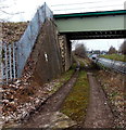
There is a bridge here which takes a railway over the canal.


Amenities

Amenities nearby at Former Factory Dam Narrows

 Autogas Logistics M-F 5.45pm Sa 1pm
 
Maps
If you are a user and are logged on, or if you are actively planning a route, a map will be displayed here.
Show on external mapping site: Google | OSM | Bing
 
Additional information

New bridge installed over a seven-day period between Christmas and New Year in 2021-22. The bridge was constructed in sections nearby and craned into place

Re-instatement of the canal channel and towpath was completed in May 2022 and the bridge was officially opened on May 23.

 
External websites
 Ocean Jubilee Bridge — associated with this page
Web page about the rebuild
 
Nearest facilities

Mouseover for more information or show routes to facility

Nearest water point

In the direction of Walk Bridge

Saul Junction Marina3 miles, 5¼ furlongs and 8 locks away
Travel to Walk Bridge, then on the Cotswold Canals (Stroudwater Navigation - Navigable Section) to Saul Junction Marina
Saul Junction Winding Hole3 miles, 6¾ furlongs and 8 locks away
Travel to Walk Bridge, then on the Cotswold Canals (Stroudwater Navigation - Navigable Section) to Saul Junction, then on the Gloucester and Sharpness Canal to Saul Junction Winding Hole
Cotswold Canals Trust Visitor Centre - Saul Junction3 miles, 7½ furlongs and 8 locks away
Travel to Walk Bridge, then on the Cotswold Canals (Stroudwater Navigation - Navigable Section) to Saul Junction, then on the Gloucester and Sharpness Canal to Cotswold Canals Trust Visitor Centre - Saul Junction
Fretherne Bridge4 miles, 4¾ furlongs and 8 locks away
Travel to Walk Bridge, then on the Cotswold Canals (Stroudwater Navigation - Navigable Section) to Saul Junction, then on the Gloucester and Sharpness Canal to Fretherne Bridge
Splatt Bridge5 miles, 5½ furlongs and 8 locks away
Travel to Walk Bridge, then on the Cotswold Canals (Stroudwater Navigation - Navigable Section) to Saul Junction, then on the Gloucester and Sharpness Canal to Splatt Bridge
Patch Bridge7 miles, 4¼ furlongs and 8 locks away
Travel to Walk Bridge, then on the Cotswold Canals (Stroudwater Navigation - Navigable Section) to Saul Junction, then on the Gloucester and Sharpness Canal to Patch Bridge
Sellars Bridge7 miles, 4½ furlongs and 8 locks away
Travel to Walk Bridge, then on the Cotswold Canals (Stroudwater Navigation - Navigable Section) to Saul Junction, then on the Gloucester and Sharpness Canal to Sellars Bridge
Purton Lower Bridge10 miles and 8 locks away
Travel to Walk Bridge, then on the Cotswold Canals (Stroudwater Navigation - Navigable Section) to Saul Junction, then on the Gloucester and Sharpness Canal to Purton Lower Bridge
Llanthony Pontoons11 miles, 2½ furlongs and 8 locks away
Travel to Walk Bridge, then on the Cotswold Canals (Stroudwater Navigation - Navigable Section) to Saul Junction, then on the Gloucester and Sharpness Canal to Llanthony Pontoons
Llanthony Road Bridge11 miles, 3¼ furlongs and 8 locks away
Travel to Walk Bridge, then on the Cotswold Canals (Stroudwater Navigation - Navigable Section) to Saul Junction, then on the Gloucester and Sharpness Canal to Llanthony Road Bridge
Gloucester Waterways Museum Arm11 miles, 3¾ furlongs and 8 locks away
Travel to Walk Bridge, then on the Cotswold Canals (Stroudwater Navigation - Navigable Section) to Saul Junction, then on the Gloucester and Sharpness Canal to Gloucester Waterways Museum Arm
Gloucester Dock Lock11 miles, 4½ furlongs and 8 locks away
Travel to Walk Bridge, then on the Cotswold Canals (Stroudwater Navigation - Navigable Section) to Saul Junction, then on the Gloucester and Sharpness Canal to Gloucester Dock Lock

Nearest rubbish disposal

In the direction of Walk Bridge

Saul Junction Marina3 miles, 5¼ furlongs and 8 locks away
Travel to Walk Bridge, then on the Cotswold Canals (Stroudwater Navigation - Navigable Section) to Saul Junction Marina
Saul Junction Winding Hole3 miles, 6¾ furlongs and 8 locks away
Travel to Walk Bridge, then on the Cotswold Canals (Stroudwater Navigation - Navigable Section) to Saul Junction, then on the Gloucester and Sharpness Canal to Saul Junction Winding Hole
Fretherne Bridge4 miles, 4¾ furlongs and 8 locks away
Travel to Walk Bridge, then on the Cotswold Canals (Stroudwater Navigation - Navigable Section) to Saul Junction, then on the Gloucester and Sharpness Canal to Fretherne Bridge
Parkend Bridge5 miles, 3 furlongs and 8 locks away
Travel to Walk Bridge, then on the Cotswold Canals (Stroudwater Navigation - Navigable Section) to Saul Junction, then on the Gloucester and Sharpness Canal to Parkend Bridge
Splatt Bridge5 miles, 5½ furlongs and 8 locks away
Travel to Walk Bridge, then on the Cotswold Canals (Stroudwater Navigation - Navigable Section) to Saul Junction, then on the Gloucester and Sharpness Canal to Splatt Bridge
Patch Bridge7 miles, 4¼ furlongs and 8 locks away
Travel to Walk Bridge, then on the Cotswold Canals (Stroudwater Navigation - Navigable Section) to Saul Junction, then on the Gloucester and Sharpness Canal to Patch Bridge
Sellars Bridge7 miles, 4½ furlongs and 8 locks away
Travel to Walk Bridge, then on the Cotswold Canals (Stroudwater Navigation - Navigable Section) to Saul Junction, then on the Gloucester and Sharpness Canal to Sellars Bridge
Purton Lower Bridge10 miles and 8 locks away
Travel to Walk Bridge, then on the Cotswold Canals (Stroudwater Navigation - Navigable Section) to Saul Junction, then on the Gloucester and Sharpness Canal to Purton Lower Bridge
Sharpness Barge Arm11 miles, 3¼ furlongs and 8 locks away
Travel to Walk Bridge, then on the Cotswold Canals (Stroudwater Navigation - Navigable Section) to Saul Junction, then on the Gloucester and Sharpness Canal to Sharpness Barge Arm
Llanthony Road Bridge11 miles, 3¼ furlongs and 8 locks away
Travel to Walk Bridge, then on the Cotswold Canals (Stroudwater Navigation - Navigable Section) to Saul Junction, then on the Gloucester and Sharpness Canal to Llanthony Road Bridge

Nearest place to turn

In the direction of Walk Bridge

Saul Junction Winding Hole3 miles, 6¾ furlongs and 8 locks away
Travel to Walk Bridge, then on the Cotswold Canals (Stroudwater Navigation - Navigable Section) to Saul Junction, then on the Gloucester and Sharpness Canal to Saul Junction Winding Hole
Pegthorne Bridge Winding Hole4 miles, 3¼ furlongs and 8 locks away
Travel to Walk Bridge, then on the Cotswold Canals (Stroudwater Navigation - Navigable Section) to Saul Junction, then on the Gloucester and Sharpness Canal to Pegthorne Bridge Winding Hole
Quedgeley Oil Depot7 miles, 5¾ furlongs and 8 locks away
Travel to Walk Bridge, then on the Cotswold Canals (Stroudwater Navigation - Navigable Section) to Saul Junction, then on the Gloucester and Sharpness Canal to Quedgeley Oil Depot
Monk Meadow Dock11 miles and 8 locks away
Travel to Walk Bridge, then on the Cotswold Canals (Stroudwater Navigation - Navigable Section) to Saul Junction, then on the Gloucester and Sharpness Canal to Monk Meadow Dock
Sharpness Barge Arm11 miles, 3¼ furlongs and 8 locks away
Travel to Walk Bridge, then on the Cotswold Canals (Stroudwater Navigation - Navigable Section) to Saul Junction, then on the Gloucester and Sharpness Canal to Sharpness Barge Arm
Gloucester Docks11 miles, 4 furlongs and 8 locks away
Travel to Walk Bridge, then on the Cotswold Canals (Stroudwater Navigation - Navigable Section) to Saul Junction, then on the Gloucester and Sharpness Canal to Gloucester Docks Travel to Walk Bridge, then on the Cotswold Canals (Stroudwater Navigation - Navigable Section) to Saul Junction, then on the Gloucester and Sharpness Canal to Waterways Office (South Wales and Severn Waterways) - Canal & River Trust
Gloucester / Sharpness - Severn Junction11 miles, 4¾ furlongs and 9 locks away
Travel to Walk Bridge, then on the Cotswold Canals (Stroudwater Navigation - Navigable Section) to Saul Junction, then on the Gloucester and Sharpness Canal to Gloucester / Sharpness - Severn Junction
Upper Parting Junction14 miles, 1½ furlongs and 9 locks away
Travel to Walk Bridge, then on the Cotswold Canals (Stroudwater Navigation - Navigable Section) to Saul Junction, then on the Gloucester and Sharpness Canal to Gloucester / Sharpness - Severn Junction, then on the River Severn (main river - Worcester to Gloucester) to Upper Parting Junction
Over Winding Hole13 miles, 4½ furlongs and 10 locks away
Travel to Walk Bridge, then on the Cotswold Canals (Stroudwater Navigation - Navigable Section) to Saul Junction, then on the Gloucester and Sharpness Canal to Gloucester / Sharpness - Severn Junction, then on the River Severn (old river navigation) to Lower Parting, then on the River Severn (Maisemore Channel - Southern Section) to Over Junction, then on the Hereford and Gloucester Canal to Over Winding Hole

In the direction of Site of Entrance to Wallbridge Basin

The Ocean¼ furlongs away
On this waterway in the direction of Site of Entrance to Wallbridge Basin
Ryeford Winding Hole1 mile away
On this waterway in the direction of Site of Entrance to Wallbridge Basin
Brimscombe Port5 miles, 6½ furlongs and 11 locks away
Travel to Site of Entrance to Wallbridge Basin, then on the Cotswold Canals (Thames and Severn Canal - Wide section) to Brimscombe Port

Nearest boatyard pump-out

In the direction of Walk Bridge

Saul Junction Marina3 miles, 5¼ furlongs and 8 locks away
Travel to Walk Bridge, then on the Cotswold Canals (Stroudwater Navigation - Navigable Section) to Saul Junction Marina
Patch Bridge7 miles, 4¼ furlongs and 8 locks away
Travel to Walk Bridge, then on the Cotswold Canals (Stroudwater Navigation - Navigable Section) to Saul Junction, then on the Gloucester and Sharpness Canal to Patch Bridge
Direction of TV transmitter (From Wolfbane Cybernetic)
 
 
Geograph
 
Wikipedia

There is no page on Wikipedia called “Ocean Railway Bridge”

Wikipedia pages that might relate to Ocean Railway Bridge
[Congo–Ocean Railway] The Congo–Ocean Railway (COR; French: Chemin de fer Congo-Océan, CFCO) links the Atlantic port of Pointe-Noire (now in the Republic of Congo) with Brazzaville [Atlantic Ocean Road] causeways, viaducts and eight bridges—the most prominent being Storseisundet Bridge. The route was originally proposed as a railway line in the early 20th century [Khabarovsk Bridge] the Trans-Siberian Railway line across the Amur River near the city of Khabarovsk, Russia. The bridge remained the longest bridge in Imperial Russia and [Basin Bridge railway station] Basin Bridge Junction is a station on the Chennai Suburban Railway and serves the locality of Basin Bridge, the confluence on the Otteri Nullah and Buckingham [Victoria Bridge (Montreal)] Canadian National Railway (CNR commonly known as CN) is Mile 71.40 Subdivision St-Hyacinthe. Originally named the Great Victoria Bridge in honour of Queen [Overseas Railroad] the Florida East Coast Railway was financially unable to rebuild the destroyed sections. The roadbed and remaining bridges were sold to the State of [Devonport Kings Road railway station] Junction Railway was opened from Lydford to Devonport. This route entered the station from the west through Devonport Park Tunnel and a bridge beneath [List of tunnels and bridges in Hong Kong] Viaduct Ocean Park - Wong Chuk Hang Viaduct Aberdeen Channel Bridge Kwai Fong - Kwai Hing Viaduct Kap Shui Mun Bridge Ma Wan Viaduct Tsing Lai Bridge Tsing [Penta-Ocean] Penta-Ocean Construction Co., Ltd. (五洋建設株式会社, Goyō Kensetsu Kabushiki-gaisha) is a major Japanese construction firm. It specializes in marine works and [Intermodal freight transport] ship for Hamburg. Also see Eurasian Land Bridge. Mini land bridge – An intermodal container shipped by ocean vessel from country A to country B passes
 
Google

Results of Google Search

India's MOST DANGEROUS Rail BRIDGE PAMBAN Rameswaram ...
Oct 31, 2015 ... The Pamban Sea Bridge is a railway bridge constructed on the Palk Strait which connects the Island town of Rameswaram to the rest of India.
Pamban Bridge - Wikipedia
Pamban Bridge is a railway bridge which connects the town of Rameswaram on Pamban Island to mainland India. Opened on 24 February 1914, it was India's first sea bridge, and was the longest sea bridge in India until the opening of the Bandra-Worli ...
Train over the Sea ! Rameswaram Express on Pamban Bridge ...
Mar 3, 2013 ... India's most dangerous Bridge constructed over the Sea , Pamaban Bridge at RAMESWARAM. Chennai-Egmore Rameswaram Express aka ...
Site of Ocean Railway Bridge
Mar 1, 2018 ... This is where the Phase 1B restoration section ends. This has long since been replaced by a small culvert for the canal water and a foot tunnel ...
TRAIN ON THE DANGEROUS SEA, RAMESWARAM BRIDGE ...
May 19, 2013 ... WATCH : Train over the Sea ! Rameswaram Express on Pamban Bridge http:// www.youtube.com/watch?v=oxRpej-gkWU Excuse me for the ...
Pamban bridge: 10 awesome facts about India's first sea bridge ...
Nov 13, 2013 ... Text: TNN & Agencies It is an engineering marvel that evokes awe! Few can forget a train journey on the Pamban bridge, connecting ...
'The Ocean'
'The Ocean' is also designated a winding hol... ... 'The Ocean' looking towards Stroud (Click on ... 'The Ocean', view towards site of Ocean Railway Bridge.
Top Ten Longest Railway Bridges in India
The longest rail bridge in the country at 4.62km located in the land of attraction ... The cantilever railway bridge is the second longest sea bridge in India (after ...
Arctic Ocean Railway Report
The Arctic Ocean Railway's potential role in transportation between Finland ..... more extensive freight traffic would require not only new railway bridges but also  ...