

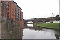
Railway Bridge No 98
Castlefield Locks, 62 Ellesmere Street, Manchester M15 4QR, United Kingdom
Railway Bridge No 98 carries a footpath over the Bridgewater Canal (Main Line) near to Doncaster.
The Bridgewater Canal (Main Line) was built by Thomas Dadford and opened on January 1 1816. The canal joined the sea near Rotherham. "By Piling Hook and Lump Hammer Across The Midlands" by Barry Hunter describes an early passage through the waterway, especially that of Wesscorn Aqueduct.

Railway Bridge No 98
is a minor waterways place
on the Bridgewater Canal (Main Line) between
Hulme Locks Branch - Bridgewater Canal Junction (Branch closed) (2 furlongs
to the northeast) and
Pomona Lock Branch Junction (Junction of Bridgewater Canal and Branch to Manchester Ship Canal) (3½ furlongs
to the southwest).
The nearest place in the direction of Hulme Locks Branch - Bridgewater Canal Junction is Former loading arm for Albert Mills;
¼ furlongs
away.
The nearest place in the direction of Pomona Lock Branch Junction is Railway Bridge No 97A;
¼ furlongs
away.
Mooring here is unrated.
There is a bridge here which takes a railway over the canal.
| St. Georges Island Footbridge | 1½ furlongs | |
| Hulme Hall Arm | 1 furlong | |
| Hulme Hall Road Winding Hole | 1 furlong | |
| Hulme Hall Road Bridge No 99 | ½ furlongs | |
| Former loading arm for Albert Mills | ¼ furlongs | |
| Railway Bridge No 98 | ||
| Railway Bridge No 97A | ¼ furlongs | |
| Site of Hulme Hall Dry Dock | ½ furlongs | |
| Cornbrook Road Bridge No 97 | 1¾ furlongs | |
| Pomona Lock Branch Junction | 3½ furlongs | |
| Metrolink or Light Railway Bridge No 96 | 3½ furlongs | |
Amenities nearby at Former loading arm for Albert Mills
There are no links to external websites from here.
Why not log in and add some (select "External websites" from the menu (sometimes this is under "Edit"))?
Why not log in and add some (select "External websites" from the menu (sometimes this is under "Edit"))?
Mouseover for more information or show routes to facility
Nearest water point
In the direction of Grocer's Wharf
Potato Wharf Arm & The New Basin — 3½ furlongs away
On this waterway in the direction of Grocer's Wharf
Staffordshire, Kenworthy and other Arms — 4¼ furlongs away
On this waterway in the direction of Grocer's Wharf
New Islington Marina — 2 miles, 2 furlongs and 11 locks away
Travel to Castlefield Junction, then on the Rochdale Canal (Main Line) to New Islington Marina Entrance, then on the Rochdale Canal (New Islington Marina Arm) to New Islington Marina
Fairfield Junction — 5 miles, 4½ furlongs and 27 locks away
Travel to Castlefield Junction, then on the Rochdale Canal (Main Line) to Ducie Street Junction, then on the Ashton Canal (Main Line) to Fairfield Junction
Grove Road Bridge No 96 — 13 miles, ½ furlongs and 35 locks away
Travel to Castlefield Junction, then on the Rochdale Canal (Main Line) to Ducie Street Junction, then on the Ashton Canal (Main Line) to Ashton-under-Lyne Junction, then on the Huddersfield Narrow Canal to Grove Road Bridge No 96
Marple Services — 16 miles, 1¾ furlongs and 43 locks away
Travel to Castlefield Junction, then on the Rochdale Canal (Main Line) to Ducie Street Junction, then on the Ashton Canal (Main Line) to Dukinfield Junction, then on the Peak Forest Canal (Lower) to Marple Junction, then on the Macclesfield Canal to Marple Services
Braidbar Boats — 19 miles, 7½ furlongs and 43 locks away
Travel to Castlefield Junction, then on the Rochdale Canal (Main Line) to Ducie Street Junction, then on the Ashton Canal (Main Line) to Dukinfield Junction, then on the Peak Forest Canal (Lower) to Marple Junction, then on the Macclesfield Canal to Braidbar Boats
Littleborough Sanitary Station — 17 miles, 3 furlongs and 46 locks away
Travel to Castlefield Junction, then on the Rochdale Canal (Main Line) to Littleborough Sanitary Station
Wool Road Visitor Mooring — 19 miles, ½ furlongs and 50 locks away
Travel to Castlefield Junction, then on the Rochdale Canal (Main Line) to Ducie Street Junction, then on the Ashton Canal (Main Line) to Ashton-under-Lyne Junction, then on the Huddersfield Narrow Canal to Wool Road Visitor Mooring
In the direction of Waterloo Bridge (Runcorn)
Stretford Marina — 2 miles, 4 furlongs away
On this waterway in the direction of Waterloo Bridge (Runcorn)
Watch House Cruising Club — 3 miles, 4¼ furlongs away
On this waterway in the direction of Waterloo Bridge (Runcorn)
Worsley Visitor Moorings — 6 miles, 6 furlongs away
Travel to Stretford - Waters Meeting, then on the Bridgewater Canal (Stretford and Leigh Branch) to Worsley Visitor Moorings
Bridgewater Marina — 8 miles, 1¾ furlongs away
Travel to Stretford - Waters Meeting, then on the Bridgewater Canal (Stretford and Leigh Branch) to Bridgewater Marina
Ye Olde Number 3 Transit Moorings — 10 miles, 3¼ furlongs away
On this waterway in the direction of Waterloo Bridge (Runcorn)
Plank Lane Visitor Moorings — 14 miles, 6½ furlongs away
Travel to Stretford - Waters Meeting, then on the Bridgewater Canal (Stretford and Leigh Branch) to Leigh Bridge No 11, then on the Leeds and Liverpool Canal (Leigh Branch) to Plank Lane Visitor MooringsNearest rubbish disposal
In the direction of Grocer's Wharf
Marple Bottom Lock Bridge Winding Hole — 15 miles, ½ furlongs and 27 locks away
Travel to Castlefield Junction, then on the Rochdale Canal (Main Line) to Ducie Street Junction, then on the Ashton Canal (Main Line) to Dukinfield Junction, then on the Peak Forest Canal (Lower) to Marple Bottom Lock Bridge Winding Hole
Marple Services — 16 miles, 1¾ furlongs and 43 locks away
Travel to Castlefield Junction, then on the Rochdale Canal (Main Line) to Ducie Street Junction, then on the Ashton Canal (Main Line) to Dukinfield Junction, then on the Peak Forest Canal (Lower) to Marple Junction, then on the Macclesfield Canal to Marple Services
Braidbar Boats — 19 miles, 7½ furlongs and 43 locks away
Travel to Castlefield Junction, then on the Rochdale Canal (Main Line) to Ducie Street Junction, then on the Ashton Canal (Main Line) to Dukinfield Junction, then on the Peak Forest Canal (Lower) to Marple Junction, then on the Macclesfield Canal to Braidbar Boats
Wool Road Visitor Mooring — 19 miles, ½ furlongs and 50 locks away
Travel to Castlefield Junction, then on the Rochdale Canal (Main Line) to Ducie Street Junction, then on the Ashton Canal (Main Line) to Ashton-under-Lyne Junction, then on the Huddersfield Narrow Canal to Wool Road Visitor Mooring
In the direction of Waterloo Bridge (Runcorn)
Plank Lane Pump Out — 14 miles, 7 furlongs away
Travel to Stretford - Waters Meeting, then on the Bridgewater Canal (Stretford and Leigh Branch) to Leigh Bridge No 11, then on the Leeds and Liverpool Canal (Leigh Branch) to Plank Lane Pump OutNearest chemical toilet disposal
In the direction of Grocer's Wharf
Fairfield Junction — 5 miles, 4½ furlongs and 27 locks away
Travel to Castlefield Junction, then on the Rochdale Canal (Main Line) to Ducie Street Junction, then on the Ashton Canal (Main Line) to Fairfield Junction
Grove Road Bridge No 96 — 13 miles, ½ furlongs and 35 locks away
Travel to Castlefield Junction, then on the Rochdale Canal (Main Line) to Ducie Street Junction, then on the Ashton Canal (Main Line) to Ashton-under-Lyne Junction, then on the Huddersfield Narrow Canal to Grove Road Bridge No 96
Marple Services — 16 miles, 1¾ furlongs and 43 locks away
Travel to Castlefield Junction, then on the Rochdale Canal (Main Line) to Ducie Street Junction, then on the Ashton Canal (Main Line) to Dukinfield Junction, then on the Peak Forest Canal (Lower) to Marple Junction, then on the Macclesfield Canal to Marple Services
Littleborough Sanitary Station — 17 miles, 3 furlongs and 46 locks away
Travel to Castlefield Junction, then on the Rochdale Canal (Main Line) to Littleborough Sanitary Station
Wool Road Visitor Mooring — 19 miles, ½ furlongs and 50 locks away
Travel to Castlefield Junction, then on the Rochdale Canal (Main Line) to Ducie Street Junction, then on the Ashton Canal (Main Line) to Ashton-under-Lyne Junction, then on the Huddersfield Narrow Canal to Wool Road Visitor Mooring
In the direction of Waterloo Bridge (Runcorn)
Watch House Cruising Club — 3 miles, 4¼ furlongs away
On this waterway in the direction of Waterloo Bridge (Runcorn)
Oughtrington Wharf — 12 miles, 1¼ furlongs away
On this waterway in the direction of Waterloo Bridge (Runcorn)Nearest place to turn
In the direction of Grocer's Wharf
Hulme Hall Road Winding Hole — 1 furlong away
On this waterway in the direction of Grocer's Wharf
Hulme Locks Branch - Bridgewater Canal Junction — 2 furlongs away
On this waterway in the direction of Grocer's Wharf
Potato Wharf Arm & The New Basin — 3½ furlongs away
On this waterway in the direction of Grocer's Wharf
Staffordshire, Kenworthy and other Arms — 4¼ furlongs away
On this waterway in the direction of Grocer's Wharf
Castlefield Junction — 4½ furlongs away
On this waterway in the direction of Grocer's Wharf
Grocer's Wharf — 5¼ furlongs away
On this waterway in the direction of Grocer's Wharf
Middlewood Basin No 1 — 6¾ furlongs and 3 locks away
Travel to Hulme Locks Branch - Bridgewater Canal Junction, then on the Bridgewater Canal (Hulme Locks Branch) to River Irwell - Hulme Locks Branch Junction, then on the Manchester Ship Canal (River Irwell Upper Reach) to Manchester, Bolton and Bury Canal - River Irwell Junction, then on the Manchester Bolton and Bury Canal (Main Line) to Middlewood Basin No 1
Middlewood Basin No 2 — 7¼ furlongs and 3 locks away
Travel to Hulme Locks Branch - Bridgewater Canal Junction, then on the Bridgewater Canal (Hulme Locks Branch) to River Irwell - Hulme Locks Branch Junction, then on the Manchester Ship Canal (River Irwell Upper Reach) to Manchester, Bolton and Bury Canal - River Irwell Junction, then on the Manchester Bolton and Bury Canal (Main Line) to Middlewood Basin No 2
Salford Tunnel Basin — 1 mile, ¼ furlongs and 4 locks away
Travel to Hulme Locks Branch - Bridgewater Canal Junction, then on the Bridgewater Canal (Hulme Locks Branch) to River Irwell - Hulme Locks Branch Junction, then on the Manchester Ship Canal (River Irwell Upper Reach) to Manchester, Bolton and Bury Canal - River Irwell Junction, then on the Manchester Bolton and Bury Canal (Main Line) to Salford Tunnel Basin
In the direction of Waterloo Bridge (Runcorn)
Pomona Lock Branch Junction — 3½ furlongs away
On this waterway in the direction of Waterloo Bridge (Runcorn)
Stretford - Waters Meeting — 2 miles, 2 furlongs away
On this waterway in the direction of Waterloo Bridge (Runcorn)
Stretford Marina — 2 miles, 4 furlongs away
On this waterway in the direction of Waterloo Bridge (Runcorn)
Edge Lane Winding Hole — 3 miles, 2½ furlongs away
On this waterway in the direction of Waterloo Bridge (Runcorn)
Trafford Park Winding Hole — 3 miles, 4¼ furlongs away
Travel to Stretford - Waters Meeting, then on the Bridgewater Canal (Stretford and Leigh Branch) to Trafford Park Winding Hole
Patricroft Basin and Warehouse — 4 miles, 6¾ furlongs away
Travel to Stretford - Waters Meeting, then on the Bridgewater Canal (Stretford and Leigh Branch) to Patricroft Basin and Warehouse
Patricroft Bridge Winding Hole — 4 miles, 7¾ furlongs away
Travel to Stretford - Waters Meeting, then on the Bridgewater Canal (Stretford and Leigh Branch) to Patricroft Bridge Winding Hole
Monton Turn — 5 miles, 5¾ furlongs away
Travel to Stretford - Waters Meeting, then on the Bridgewater Canal (Stretford and Leigh Branch) to Monton Turn
Winding Hole (east of Worsley) — 6 miles, 3¾ furlongs away
Travel to Stretford - Waters Meeting, then on the Bridgewater Canal (Stretford and Leigh Branch) to Winding Hole (east of Worsley)
Worsley Delph — 6 miles, 6¼ furlongs away
Travel to Stretford - Waters Meeting, then on the Bridgewater Canal (Stretford and Leigh Branch) to Worsley Delph
Seamon's Moss Winding Hole — 8 miles, ¾ furlongs away
On this waterway in the direction of Waterloo Bridge (Runcorn)Nearest self-operated pump-out
In the direction of Grocer's Wharf
New Islington Marina — 2 miles, 2 furlongs and 11 locks away
Travel to Castlefield Junction, then on the Rochdale Canal (Main Line) to New Islington Marina Entrance, then on the Rochdale Canal (New Islington Marina Arm) to New Islington Marina
Wool Road Visitor Mooring — 19 miles, ½ furlongs and 50 locks away
Travel to Castlefield Junction, then on the Rochdale Canal (Main Line) to Ducie Street Junction, then on the Ashton Canal (Main Line) to Ashton-under-Lyne Junction, then on the Huddersfield Narrow Canal to Wool Road Visitor Mooring
In the direction of Waterloo Bridge (Runcorn)
Plank Lane Pump Out — 14 miles, 7 furlongs away
Travel to Stretford - Waters Meeting, then on the Bridgewater Canal (Stretford and Leigh Branch) to Leigh Bridge No 11, then on the Leeds and Liverpool Canal (Leigh Branch) to Plank Lane Pump OutNearest boatyard pump-out
In the direction of Grocer's Wharf
Portland Basin Arm — 8 miles, ¾ furlongs and 27 locks away
Travel to Castlefield Junction, then on the Rochdale Canal (Main Line) to Ducie Street Junction, then on the Ashton Canal (Main Line) to Dukinfield Junction, then on the Peak Forest Canal (Lower) to Portland Basin Arm
Braidbar Boats — 19 miles, 7½ furlongs and 43 locks away
Travel to Castlefield Junction, then on the Rochdale Canal (Main Line) to Ducie Street Junction, then on the Ashton Canal (Main Line) to Dukinfield Junction, then on the Peak Forest Canal (Lower) to Marple Junction, then on the Macclesfield Canal to Braidbar Boats
In the direction of Waterloo Bridge (Runcorn)
Stretford Marina — 2 miles, 4 furlongs away
On this waterway in the direction of Waterloo Bridge (Runcorn)
Bridgewater Marina — 8 miles, 1¾ furlongs away
Travel to Stretford - Waters Meeting, then on the Bridgewater Canal (Stretford and Leigh Branch) to Bridgewater Marina
Oughtrington Wharf — 12 miles, 1¼ furlongs away
On this waterway in the direction of Waterloo Bridge (Runcorn)Direction of TV transmitter (From Wolfbane Cybernetic)
. by David Dixon – 22 February 2017")

 line out of central Manchester. Originally this was built by the Manchester South Junction and Altrincham Railway in 1849, and electrified by the LMS in 1930 at 1500V DC, but this was converted to 25KV AC in 1971 because of the obsolescence of the original equipment. The blue-brick viaduct in the background was built by the Cheshire Lines Committee for their line to Liverpool, but the usage of the routes were reversed when the Metrolink was constructed in 1992. The train is a class 185 DMU operated by First Transpennine. by Jonathan Wilkins – 27 June 2010")


. by David Dixon – 04 September 2017")


 by Anthony O'Neil – 21 February 2018")


 which run parallel to the River Irwell are on substantial viaducts at this point. The most easterly now carries the railway to Warrington (Central) and is constructed of red brick, while the more westerly (now carrying the Metrolink) are built with blue brick. It is fine to see such grand engineering still in use so long after its conception. by Jonathan Wilkins – 27 June 2010")


 from Woden Street Footbridge. The river here marks the boundary between Salford (to the left) and Manchester. SJ825973. by Keith Williamson – 01 September 2005")


 at Pomona Wharf. A view looking downstream (towards the former docks at Salford Quays) from the Woden Street footbridge. by David Dixon – 02 November 2021")


Wikipedia has a page about Railway Bridge
Railway Bridge may refer to:
- Jonava railway bridge, bridge that crosses the Neris River in Lithuania
- Railway Bridge, Riga, bridge that crosses the Daugava river in Riga, Latvia
- Railway Bridge, Kaunas, bridge that crosses the Nemunas River in Lithuania
Other Wikipedia pages that might relate to Railway Bridge
[Bridge]
double-decked bridge. The upper level carries a railway, and the lower level is used for road traffic. Other examples include Britannia Bridge over the Menai
[Chenab Bridge]
The Chenab Bridge is an Indian railway steel and concrete arch bridge under construction between Bakkal and Kauri in the Reasi district of Jammu and Kashmir
[Forth Bridge]
The Forth Bridge is a cantilever railway bridge across the Firth of Forth in the east of Scotland, 9 miles (14 kilometres) west of central Edinburgh.
[Pamban Bridge]
Pamban Bridge is a railway bridge which connects the town of Mandapam in mainland India with Pamban Island, and Rameswaram. Opened on 24 February 1914
[Blackfriars Railway Bridge]
Blackfriars Railway Bridge is a railway bridge crossing the River Thames in London, between Blackfriars Bridge and the Millennium Bridge. There have been
[Maidenhead Railway Bridge]
Maidenhead Railway Bridge (also known as Maidenhead Viaduct, The Sounding Arch) is a single structure of two tall wide red brick arches buttressed by two
[Ludendorff Bridge]
were the Hindenburg Bridge at Bingen am Rhein and the Urmitz Bridge on the Neuwied–Koblenz railway near Koblenz. The railway bridge had three spans: two
[Crimean Bridge]
and railway bridge started in April 1943, but before it was finished, retreating German troops blew up the already completed parts of the bridge and destroyed
[Severn Railway Bridge]
The Severn Railway Bridge (historically called the Severn Bridge) was a bridge carrying the railway across the River Severn between Sharpness and Lydney
Results of Google Search
The Eschede derailment occurred on 3 June 1998, near the village of Eschede in the Celle district of Lower Saxony, Germany, when a high-speed train derailed and crashed into a road bridge. 101 people were killed and 88 were injured. It remains the worst rail disaster in the history of the Federal Republic of ... The conductor did not show a willingness to stop the train immediately at that ...
Tendencies in steel railway bridge design towards a greater influence of architects on ... These designs also show that modern architecture and cost- effectiveness do not have to be mutually exclusive. ... Publication status, Published - 1998Â ...
Jan 26, 2005 ... ... Corporation and Norfolk Southern Railway Company (collectively, NS) ... Control—Conrail Inc. et al., 3 S.T.B. 196 (1998). ... Any employee affected by the Toledo Pivot Bridge purchase exempted in STB Finance Docket No.
Jul 7, 2015 ... The Codorus Bridge (#98) was one of many railroad bridges put out of ... However it would not burn; evidently this Howe-truss bridge had been ...
Approach by BOT agency and Bridge. Proper by. Railways. Page 1 / 2. Peso ... For Financial Commissioner/railways. No. 98/CE-I/Misc. (14) BRO. New Delhi ...
Sep 14, 2019 ... Stretching 320 feet (98 metres), the bridge links the core part of campus on ... The curving bridge, which passes over five active rail lines, also ...
No.98/. W1/Gen1/0/30-Pt. FA & CAOS,. All Indian Railways. Sub: Preparation of Estimates. ... bridges have been taken into account while finalizing L-section ?
Dec 3, 2019 ... Turn left along the towpath (DO NOT go under the bridge you have just crossed ... Car Showrooms just before Radford Bridge (No 98), take the footpath ... Then follow the path under the railway bridge and carry on up the track ...
92 & 93, Major Bridges No.98, 99, 166 & 169, Minor Bridges No.95, 96, 97, 100 & 101 including dismantling of existing Br. No. 166 & 169 and Earthwork for ...