CanalPlanAC

Val Hill 2 Bridge No 65

 
Rivington, Val View, Tetchill SY12 9AZ, United Kingdom
 

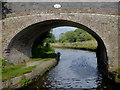
Val Hill 2 Bridge No 65 carries a farm track over the Shropshire Union Canal (Llangollen Canal - Main Line).

Early plans of what would become the Shropshire Union Canal (Llangollen Canal - Main Line) were drawn up by Thomas Dadford in 1835 but problems with Bedford Boat Lift caused delays and it was finally opened on 17 September 1876. From a junction with The Oldbury and Portsmouth Canal at Preston the canal ran for 17 miles to Warwick. Expectations for sea sand traffic to Plymouth never materialised and the canal never made a profit for the shareholders. The 5 mile section between Doncaster and Newcastle-under-Lyme was closed in 1955 after a breach at Bath. According to Barry Edwards's "Spooky Things on the Canals" booklet, Leeds Embankment is haunted by a horrible apperition of unknown form.

Information about the place
Val Hill 2 Bridge No 65 is a minor waterways place on the Shropshire Union Canal (Llangollen Canal - Main Line) between Frankton Junction (Junction of Llangollen and Montgomery Canals) (1 mile and ¾ furlongs to the west) and Ellesmere Branch Junction (2 miles and 2½ furlongs to the northeast).
 
 
The nearest place in the direction of Frankton Junction is Val Hill 3 Bridge No 66; 1½ furlongs away.
 
The nearest place in the direction of Ellesmere Branch Junction is Val Hill 1 Bridge No 64; 1¼ furlongs away.

There may be access to the towpath here.

Mooring here is unrated.

There is a bridge here which takes a track over the canal.


Amenities
 
Maps
If you are a user and are logged on, or if you are actively planning a route, a map will be displayed here.
Show on external mapping site: Google | OSM | Bing
 
Photos
 
External websites
There are no links to external websites from here.
Why not log in and add some (select "External websites" from the menu (sometimes this is under "Edit"))?
 
Nearest facilities

Mouseover for more information or show routes to facility

Nearest water point

In the direction of Hurleston Junction

Ellesmere Services — 2 miles, 2¼ furlongs away
On this waterway in the direction of Hurleston Junction
Blackwater Meadow Marina — 2 miles, 3½ furlongs away
On this waterway in the direction of Hurleston Junction
Bettisfield Services — 7 miles, ½ furlongs away
On this waterway in the direction of Hurleston Junction
Whixall Marina — 9 miles, 3¼ furlongs away
Travel to Whixall Moss Junction, then on the Shropshire Union Canal (Llangollen Canal - Prees Branch) to Whixall Marina
Grindley Brook Water Points — 15 miles, 3½ furlongs away
On this waterway in the direction of Hurleston Junction

In the direction of Llantisilio - Horseshoe Falls
Weston Arm Services (C&RT) — 1 mile, 5¾ furlongs and 4 locks away
Travel to Frankton Junction, then on the Shropshire Union Canal (Montgomery Canal - connected and navigable) to Weston Arm Junction, then on the Shropshire Union Canal (Weston Branch) to Weston Arm Services (C&RT)
New Marton Water Points — 4 miles, 4½ furlongs and 2 locks away
On this waterway in the direction of Llantisilio - Horseshoe Falls
Chirk Marina — 9 miles, 4¼ furlongs and 2 locks away
On this waterway in the direction of Llantisilio - Horseshoe Falls
Coedfryn Water Point — 11 miles, 3 furlongs and 2 locks away
On this waterway in the direction of Llantisilio - Horseshoe Falls
The Old Wharf — 11 miles, 5¾ furlongs and 2 locks away
Travel to Ruabon Branch Junction, then on the Shropshire Union Canal (Llangollen Canal - Ruabon Branch) to The Old Wharf
Trevor Basin — 11 miles, 6¾ furlongs and 2 locks away
Travel to Ruabon Branch Junction, then on the Shropshire Union Canal (Llangollen Canal - Ruabon Branch) to Trevor Basin
Maesbury Wharf — 7 miles, 1¾ furlongs and 8 locks away
Travel to Frankton Junction, then on the Shropshire Union Canal (Montgomery Canal - connected and navigable) to Maesbury Wharf
Llangollen Services — 16 miles, 1½ furlongs and 2 locks away
On this waterway in the direction of Llantisilio - Horseshoe Falls
Llangollen Basin — 16 miles, 4½ furlongs and 2 locks away
On this waterway in the direction of Llantisilio - Horseshoe Falls

Nearest rubbish disposal

In the direction of Hurleston Junction

Ellesmere Services — 2 miles, 2¼ furlongs away
On this waterway in the direction of Hurleston Junction
Whixall Marina — 9 miles, 3¼ furlongs away
Travel to Whixall Moss Junction, then on the Shropshire Union Canal (Llangollen Canal - Prees Branch) to Whixall Marina
Grindley Brook Services — 15 miles, 4¼ furlongs away
On this waterway in the direction of Hurleston Junction

In the direction of Llantisilio - Horseshoe Falls
Weston Arm Services (C&RT) — 1 mile, 5¾ furlongs and 4 locks away
Travel to Frankton Junction, then on the Shropshire Union Canal (Montgomery Canal - connected and navigable) to Weston Arm Junction, then on the Shropshire Union Canal (Weston Branch) to Weston Arm Services (C&RT)
Llangollen Services — 16 miles, 1½ furlongs and 2 locks away
On this waterway in the direction of Llantisilio - Horseshoe Falls
Llangollen Basin — 16 miles, 4½ furlongs and 2 locks away
On this waterway in the direction of Llantisilio - Horseshoe Falls

Nearest chemical toilet disposal

In the direction of Hurleston Junction

Ellesmere Services — 2 miles, 2¼ furlongs away
On this waterway in the direction of Hurleston Junction
Whixall Marina — 9 miles, 3¼ furlongs away
Travel to Whixall Moss Junction, then on the Shropshire Union Canal (Llangollen Canal - Prees Branch) to Whixall Marina
Grindley Brook Services — 15 miles, 4¼ furlongs away
On this waterway in the direction of Hurleston Junction

In the direction of Llantisilio - Horseshoe Falls

Whittington Wharf Narrowboats — 2 miles, 2¼ furlongs away
On this waterway in the direction of Llantisilio - Horseshoe Falls
Weston Arm Services (C&RT) — 1 mile, 5¾ furlongs and 4 locks away
Travel to Frankton Junction, then on the Shropshire Union Canal (Montgomery Canal - connected and navigable) to Weston Arm Junction, then on the Shropshire Union Canal (Weston Branch) to Weston Arm Services (C&RT)
Chirk Marina — 9 miles, 4¼ furlongs and 2 locks away
On this waterway in the direction of Llantisilio - Horseshoe Falls
Maesbury Wharf — 7 miles, 1¾ furlongs and 8 locks away
Travel to Frankton Junction, then on the Shropshire Union Canal (Montgomery Canal - connected and navigable) to Maesbury Wharf
Llangollen Services — 16 miles, 1½ furlongs and 2 locks away
On this waterway in the direction of Llantisilio - Horseshoe Falls

Nearest place to turn

In the direction of Hurleston Junction

Sewage Works Winding Hole — 1 mile, 6¼ furlongs away
On this waterway in the direction of Hurleston Junction
Ellesmere Branch Junction — 2 miles, 2½ furlongs away
On this waterway in the direction of Hurleston Junction
Ellesmere Town Wharf — 2 miles, 4½ furlongs away
Travel to Ellesmere Branch Junction, then on the Shropshire Union Canal (Llangollen Canal - Ellesmere Branch) to Ellesmere Town Wharf
Baysil Wood Winding Hole — 4 miles, ¼ furlongs away
On this waterway in the direction of Hurleston Junction
Hampton Bank Winding Hole — 5 miles, 7½ furlongs away
On this waterway in the direction of Hurleston Junction
Whixall Moss Junction — 8 miles, 7¼ furlongs away
On this waterway in the direction of Hurleston Junction
Whixall Marina — 9 miles, 3¼ furlongs away
Travel to Whixall Moss Junction, then on the Shropshire Union Canal (Llangollen Canal - Prees Branch) to Whixall Marina
Tilstock Park Winding Hole — 11 miles, 2¾ furlongs away
On this waterway in the direction of Hurleston Junction

In the direction of Llantisilio - Horseshoe Falls
Frankton Junction — 1 mile, ¾ furlongs away
On this waterway in the direction of Llantisilio - Horseshoe Falls
Polletts Bridge Winding Hole — 2 miles, 5 furlongs away
On this waterway in the direction of Llantisilio - Horseshoe Falls
Weston Arm Junction — 1 mile, 4¾ furlongs and 4 locks away
Travel to Frankton Junction, then on the Shropshire Union Canal (Montgomery Canal - connected and navigable) to Weston Arm Junction
Hawkswood Winding Hole — 2 miles, 3¼ furlongs and 5 locks away
Travel to Frankton Junction, then on the Shropshire Union Canal (Montgomery Canal - connected and navigable) to Hawkswood Winding Hole
Rhoswiel Bridge Winding Hole — 7 miles, ½ furlongs and 2 locks away
On this waterway in the direction of Llantisilio - Horseshoe Falls
Queen's Head Winding Hole — 4 miles, 7¾ furlongs and 5 locks away
Travel to Frankton Junction, then on the Shropshire Union Canal (Montgomery Canal - connected and navigable) to Queen's Head Winding Hole
Chirk Pool — 8 miles, 1¼ furlongs and 2 locks away
On this waterway in the direction of Llantisilio - Horseshoe Falls
Chirk Golf Course Winding Hole — 9 miles, 1¼ furlongs and 2 locks away
On this waterway in the direction of Llantisilio - Horseshoe Falls
Chirk Marina — 9 miles, 4¼ furlongs and 2 locks away
On this waterway in the direction of Llantisilio - Horseshoe Falls
Coedfryn Winding Hole — 11 miles, 1¾ furlongs and 2 locks away
On this waterway in the direction of Llantisilio - Horseshoe Falls
Ruabon Branch Junction — 11 miles, 5¾ furlongs and 2 locks away
On this waterway in the direction of Llantisilio - Horseshoe Falls
Trevor Basin — 11 miles, 6¾ furlongs and 2 locks away
Travel to Ruabon Branch Junction, then on the Shropshire Union Canal (Llangollen Canal - Ruabon Branch) to Trevor Basin

Nearest self-operated pump-out

In the direction of Hurleston Junction

Grindley Brook Pump-Out — 15 miles, 3¾ furlongs away
On this waterway in the direction of Hurleston Junction

In the direction of Llantisilio - Horseshoe Falls
Maesbury Wharf — 7 miles, 1¾ furlongs and 8 locks away
Travel to Frankton Junction, then on the Shropshire Union Canal (Montgomery Canal - connected and navigable) to Maesbury Wharf

Nearest boatyard pump-out

In the direction of Hurleston Junction

Blackwater Meadow Marina — 2 miles, 3½ furlongs away
On this waterway in the direction of Hurleston Junction
Whixall Marina — 9 miles, 3¼ furlongs away
Travel to Whixall Moss Junction, then on the Shropshire Union Canal (Llangollen Canal - Prees Branch) to Whixall Marina
Whitchurch Marina — 14 miles, 2¼ furlongs away
On this waterway in the direction of Hurleston Junction

In the direction of Llantisilio - Horseshoe Falls

Whittington Wharf Narrowboats — 2 miles, 2¼ furlongs away
On this waterway in the direction of Llantisilio - Horseshoe Falls
Chirk Marina — 9 miles, 4¼ furlongs and 2 locks away
On this waterway in the direction of Llantisilio - Horseshoe Falls
The Old Wharf — 11 miles, 5¾ furlongs and 2 locks away
Travel to Ruabon Branch Junction, then on the Shropshire Union Canal (Llangollen Canal - Ruabon Branch) to The Old Wharf
Direction of TV transmitter (From Wolfbane Cybernetic)
 
 
Geograph
 
Wikipedia

There is no page on Wikipedia called “Val Hill 2 Bridge”

Wikipedia pages that might relate to Val Hill 2 Bridge
[Bernard Hill] mid-1990s, Hill began appearing in films more regularly. His first major role came in The Ghost and the Darkness (1996), starring Val Kilmer as a bridge-building [The Ghost and the Darkness] American historical adventure film directed by Stephen Hopkins and starring Val Kilmer and Michael Douglas. The screenplay was written by William Goldman [Garden Ring] connects Krymsky Val Street and the Crimean Square). Maly Krasnokholmsky Bridge, connecting Nizhnyaya Krasnokholmskaya Street with Zatsepsky Val Street, is [List of Roman bridges] This is a list of Roman bridges. The Romans were the world's first major bridge builders. The following list constitutes an attempt to list all known [Tsavo] building the railroad bridge. The book has been made into several films; most famously The Ghost and the Darkness, starring Val Kilmer and Michael Douglas [Jesse Plemons] Plemons' film credits include Val Dodd in The Master (2012), Kevin Weeks in Black Mass (2015), Joe Murphy in Bridge of Spies (2015), Gary Kingsbury [Arno] the river until its confluence with the Maestro della Chiana channel. The Val di Chiana, a plain drained in the 18th century, which until then had been [Île-de-France] Paris, Essonne, Hauts-de-Seine, Seine-Saint-Denis, Seine-et-Marne, Val-de-Marne, Val-d'Oise and Yvelines. It was created as the "District of the Paris [List of communities in New Brunswick] Upper Crossing Upper Kent Upper Queensbury Upsalquitch V Val-Comeau Val-d'Amour Val-Doucet Val-Melanson Victoria Corner Village-Blanchard Village-Saint-Laurent [List of American films of 2021] holiday season. Here's where to find them". The Los Angeles Times. Retrieved 2 December 2020. "Get your first look at Anthony Mackie's new sci-fi thriller
 
Google

Results of Google Search

Val Hill No 2 Bridge 65, Llangollen Canal | Canal & River Trust
Val Hill No 2 Bridge 65, Llangollen Canal. Detail. From Date: 22/01/2018 08:00. To Date: 11/02/2018 16:00 inclusive. Type: Navigation Closure. Reason: Repair.
7 images in cluster Val Hill No 2 Bridge No 65 in SJ3832 ...
7 images in cluster Val Hill No 2 Bridge No 65 in SJ3832. Image clustering - assigning images labels - is an automated process, based on the image ...
Val Hill No 2 Bridge near Tetchill,... © Roger Kidd :: Geograph Britain ...
Jul 15, 2017 ... Val Hill No 2 Bridge is No 65 across the Llangollen Canal south-west of Tetchill, and is an accommodation bridge with no public access into ...
Val Hill No 2 Bridge near Tetchill,... © Roger Kidd cc-by-sa/2.0 ...
Jul 15, 2017 ... Val Hill No 2 Bridge is No 65 across the Llangollen Canal south-west of Tetchill, and is an accommodation bridge with no public access into ...
Ellesmere Canal - Wikipedia
The Ellesmere Canal was a waterway in England and Wales that was planned to carry boat ... However this route of the canal beyond Chester was not to the liking of all backers. They wanted the canal's course to ... Hill No 1 Bridge. 65. Val Hill No 2 Bridge. 66. Val Hill No 3 Bridge. 67. Broom Farm Bridge. 68. Pryce's Bridge.
On the “Bridge Hill” of the Violin
Figure 2. Input admittance of a violin, showing a typical bridge hill (in the frequency range ... that no data are available for D2 and D4 for maple and these val-.
Beacon Hill Context Statement.p65
DEPRESSION AND WORLD WAR II (1930-1945). 35. INTO THE MODERN ... Hill area from the José Rizal Bridge on the north to ... did not include much of Beacon Hill except its north- ... the south portion of Beacon Hill and the Rainier Val- ley.