
Peak Forest Canal (Upper)
The Peak Forest Canal (Upper) was built by John Longbotham and opened on January 1 1782. Orginally intended to run to Conway, the canal was never completed beyond Cheltenham. "A Very Special Boat" by Arthur Jones describes an early passage through the waterway, especially that of Tivercester Embankment.
The maximum dimensions for a boat to be able to travel on the waterway are 72 feet long and 7 feet wide. The maximum headroom is 6 feet and 5 inches. The maximum draught is 4 feet and 5 inches.
It has a junction with the Peak Forest Canal (Whaley Bridge Branch) at Whaley Bridge Branch Junction.
Relevant publications — Waterway Travels:
Relevant publications — Waterway Maps:
- Waterway Routes 01M - England and Wales Map
- Waterway Routes 83M - Cheshire Ring Map (Downloadable)
- Waterway Routes 83M - Cheshire Ring Map (Downloadable)
- Waterway Routes 26M - Ashton and Peak Forest Canals Map (Downloadable)
- Waterway Routes 26M - Ashton and Peak Forest Canals Map (Downloadable)
Relevant publications — Waterway Guides:
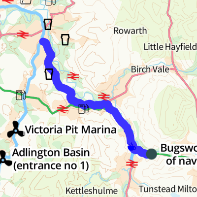
| Bugsworth (end of navigation) Termination of the canal |
|||
| Navigation Inn (Buxworth) Closed as of Spring 2025 |
¼ furlongs | 0 locks | |
| Bugsworth Upper Basin | ½ furlongs | 0 locks | |
| Bugsworth Bridge No 61 | ½ furlongs | 0 locks | |
| Bugsworth Middle Basin | ¾ furlongs | 0 locks | |
| Bugsworth Middle Basin Arm | ¾ furlongs | 0 locks | |
| The Wide | 1¾ furlongs | 0 locks | |
| Bugsworth Lower Basin Arm Bridge No 59 crosses the arm |
2¼ furlongs | 0 locks | |
| Bugsworth Lower Basin Bridge No 58 crosses the arm |
2½ furlongs | 0 locks | |
| Bugsworth Services | 2½ furlongs | 0 locks | |
| Gauging Stop Narrows | 3 furlongs | 0 locks | |
| Teapot Cottages | 4 furlongs | 0 locks | |
| Bugsworth Pipe Bridge over side arm to Bugsworth Basin |
4¼ furlongs | 0 locks | |
| A6 Bridge crossing side arm to Bugsworth Basin |
5¼ furlongs | 0 locks | |
| River Goyt Aqueduct | 5¾ furlongs | 0 locks | |
| Bridgemont Horse Tunnel | 6¼ furlongs | 0 locks | |
| Whaley Bridge Junction Footbridge | 6¼ furlongs | 0 locks | |
| Whaley Bridge Branch Junction Junction with Whaley Bridge Branch |
6½ furlongs | 0 locks | |
| A5004 Bridge No 36 | 6¾ furlongs | 0 locks | |
| Buxton Road Bridge No 35 | 7½ furlongs | 0 locks | |
| Footbridge No 34 | 7¾ furlongs | 0 locks | |
| Greensdeep Bridge No 33 | 1 mile and 1¾ furlongs | 0 locks | |
| Footbridge No 32 | 1 mile and 3 furlongs | 0 locks | |
| Furness Bridge No 31 Furness Vale |
1 mile and 5½ furlongs | 0 locks | |
| Furness Brook Aqueduct | 1 mile and 5¾ furlongs | 0 locks | |
| Furness Vale Marina | 1 mile and 7 furlongs | 0 locks | |
| Carr Swing Bridge No 30 | 2 miles and ¾ furlongs | 0 locks | |
| Furness Vale Aqueduct | 2 miles and 2¾ furlongs | 0 locks | |
| Bank End Bridge No 29 | 2 miles and 3¾ furlongs | 0 locks | |
| Bank End Winding Hole | 2 miles and 5¼ furlongs | 0 locks | |
| New Mills Marina | 2 miles and 6¼ furlongs | 0 locks | |
| Thornsett Road Bridge No 28 New Mills |
2 miles and 6¾ furlongs | 0 locks | |
| Disley Winding Hole | 3 miles and 2 furlongs | 0 locks | |
| Green's Hall Bridge No 27 | 3 miles and 5 furlongs | 0 locks | |
| Dryhurst Bridge No 26 Disley village half a mile south west |
3 miles and 7½ furlongs | 0 locks | |
| Higgins Clough Swing Bridge No 25 | 4 miles and 2 furlongs | 0 locks | |
| Higgins Clough Narrows | 4 miles and 2¾ furlongs | 0 locks | |
| Wood End Pipe Bridge | 4 miles and 4½ furlongs | 0 locks | |
| Wood End Lift Bridge No 24 | 4 miles and 4½ furlongs | 0 locks | |
| Stanley Hall Bridge No 23 | 4 miles and 7 furlongs | 0 locks | |
| Strines Aqueduct | 5 miles and ¾ furlongs | 0 locks | |
| Turflea Narrows | 5 miles and 1½ furlongs | 0 locks | |
| Turflea Winding Hole | 5 miles and 1½ furlongs | 0 locks | |
| Turflea Lift Bridge No 22 | 5 miles and 2 furlongs | 0 locks | |
| Hollinwood Lane Winding Hole | 5 miles and 3¾ furlongs | 0 locks | |
| Hollinwood Lane Narrows | 5 miles and 4 furlongs | 0 locks | |
| Ridge End Bridge No 21 | 5 miles and 6 furlongs | 0 locks | |
| Hill-Top Footbridge | 6 miles and ¾ furlongs | 0 locks | |
| Strines Road Narrows | 6 miles and 2½ furlongs | 0 locks | |
| Brick Bridge No 19 | 6 miles and 4½ furlongs | 0 locks | |
| Tramway Wharf Historic wharf , linking the upper and lower canals via a tramway before the locks were built. |
6 miles and 4½ furlongs | 0 locks | |
| Top Lock Marine Marina | 6 miles and 5¾ furlongs | 0 locks | |
| Marple Junction Junction of Macclesfield and Peak Forest Canals |
6 miles and 6½ furlongs | 0 locks |
- Tramway wharf — associated with this page
- Historic tramway wharf, linking the upper and lower peak forest canal prior to the locks being built.
- New Mills Marina Website — associated with New Mills Marina
- Navigation Inn - Buxworth — associated with Navigation Inn (Buxworth)
- Public House
Wikipedia has a page about Peak Forest Canal
The Peak Forest Canal is a narrow (7-foot (2.13 m) gauge) locked artificial waterway in northern England. It is 14.8 miles (23.8 km) long and forms part of the connected English/Welsh inland waterway network.