

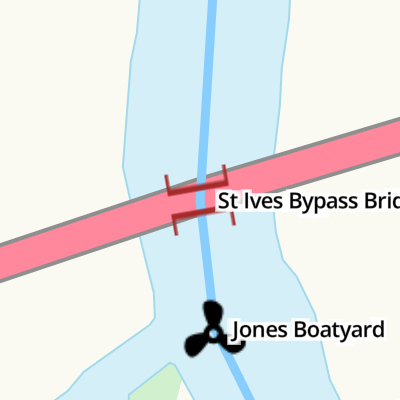
St Ives Bypass Bridge
Jones Boatyard, Harrison Way, Huntingdonshire PE27 5GF, United Kingdom
Address is taken from a point 281 yards away.
Address is taken from a point 281 yards away.
St Ives Bypass Bridge
is a minor waterways place
on the River Great Ouse (Canalized Section) between
Holywell Public Mooring (2 miles and 3 furlongs
and 1 lock
to the east) and
The Waits Moorings Junction (3½ furlongs
to the northwest).
The nearest place in the direction of Holywell Public Mooring is Jones Boatyard (Eastablished 1946);
¼ furlongs
away.
The nearest place in the direction of The Waits Moorings Junction is St Ives Town Quay Mooring;
2¼ furlongs
away.
Mooring here is unrated.
There is a bridge here which takes a major road over the canal.
| Meadow Lane Bridge (Holywell) | 1 mile, 2 furlongs | |
| St Ives Lock Weir Exit | 1 furlong | |
| St Ives Lock | ½ furlongs | |
| St Ives Lock Weir Entrance | ½ furlongs | |
| Jones Boatyard | ¼ furlongs | |
| St Ives Bypass Bridge | ||
| St Ives Town Quay Mooring | 2¼ furlongs | |
| Chapel Bridge (St Ives) | 2½ furlongs | |
| Dolphin Hotel EA Mooring Junction | 3 furlongs | |
| The Waits Moorings Junction | 3½ furlongs | |
| Nobles Field GOBA Mooring | 7 furlongs | |
Amenities nearby at St Ives Town Quay Mooring
Amenities nearby at Jones Boatyard
- Great Ouse Navigation | boating, moorings, navigation notices — associated with River Great Ouse
- Information regarding the Great Ouse navigation and tributaries.
- Information for boaters on the River Great Ouse - GOV.UK — associated with River Great Ouse
- River Great Ouse: bridge heights, locks, overhead power lines and facilities.
- Facebook Account — associated with River Great Ouse
- Anglian Waterways Manager Facebook Account
- Facebook Anglian Waterways Page — associated with River Great Ouse
- Facebook Page for Environment Agency Anglian Waterways
Mouseover for more information or show routes to facility
Nearest water point
In the direction of Kempston Mill
The Waits Moorings — 4¾ furlongs away
Travel to The Waits Moorings Junction, then on the River Great Ouse (Waits Mooring Arm) to The Waits Moorings
Hartford Marina — 4 miles, 1¼ furlongs and 2 locks away
On this waterway in the direction of Kempston Mill
Huntingdon Boathaven Marina — 6 miles, 1 furlong and 2 locks away
On this waterway in the direction of Kempston Mill
St Neots Priory Centre Mooring — 16 miles, ¼ furlongs and 6 locks away
On this waterway in the direction of Kempston Mill
In the direction of Brownshill Staunch (Lock)
Jones Boatyard — ¼ furlongs away
On this waterway in the direction of Brownshill Staunch (Lock)
Pike and Eel Marina — 4 miles, ½ furlongs and 1 lock away
On this waterway in the direction of Brownshill Staunch (Lock)
Westview Marina & Leisure Park — 6 miles, 6 furlongs and 2 locks away
Travel to Brownshill Staunch (Lock), then on the River Great Ouse (Tidal Section) to Westview Marina & Leisure Park
Fish and Duck Marina Fuel Dock — 18 miles, 7½ furlongs and 3 locks away
Travel to Brownshill Staunch (Lock), then on the River Great Ouse (Tidal Section) to Earith Junction, then on the River Great Ouse (Old West River - Small River) to Fish and Duck Marina Fuel Dock
Fish and Duck Marina — 19 miles, ½ furlongs and 3 locks away
Travel to Brownshill Staunch (Lock), then on the River Great Ouse (Tidal Section) to Earith Junction, then on the River Great Ouse (Old West River - Small River) to Pope's Corner, then on the River Cam (Main river - Large River) to Fish and Duck MarinaNearest rubbish disposal
In the direction of Kempston Mill
Buckden Marina — 9 miles, 7¾ furlongs and 4 locks away
On this waterway in the direction of Kempston Mill
St Neots Priory Centre Mooring — 16 miles, ¼ furlongs and 6 locks away
On this waterway in the direction of Kempston Mill
In the direction of Brownshill Staunch (Lock)
Hermitage Lock — 7 miles, 3½ furlongs and 2 locks away
Travel to Brownshill Staunch (Lock), then on the River Great Ouse (Tidal Section) to Earith Junction, then on the River Great Ouse (Old West River - Small River) to Hermitage LockNearest chemical toilet disposal
In the direction of Kempston Mill
Hartford Marina — 4 miles, 1¼ furlongs and 2 locks away
On this waterway in the direction of Kempston Mill
In the direction of Brownshill Staunch (Lock)
Jones Boatyard — ¼ furlongs away
On this waterway in the direction of Brownshill Staunch (Lock)
Westview Marina & Leisure Park — 6 miles, 6 furlongs and 2 locks away
Travel to Brownshill Staunch (Lock), then on the River Great Ouse (Tidal Section) to Westview Marina & Leisure Park
Fish and Duck Marina — 19 miles, ½ furlongs and 3 locks away
Travel to Brownshill Staunch (Lock), then on the River Great Ouse (Tidal Section) to Earith Junction, then on the River Great Ouse (Old West River - Small River) to Pope's Corner, then on the River Cam (Main river - Large River) to Fish and Duck MarinaNearest place to turn
In the direction of Kempston Mill
The Waits Moorings Junction — 3½ furlongs away
On this waterway in the direction of Kempston Mill
The Waits Moorings Winding Hole — 6 furlongs away
Travel to The Waits Moorings Junction, then on the River Great Ouse (Waits Mooring Arm) to The Waits Moorings Winding Hole
Hemingford Lock Weir Exit No 1 — 1 mile, 5 furlongs away
On this waterway in the direction of Kempston Mill
Hemingford Lock Weir Exit No 2 — 1 mile, 5¼ furlongs away
On this waterway in the direction of Kempston Mill
Houghton Lock Weir Exit No 1 — 2 miles, 3½ furlongs and 1 lock away
On this waterway in the direction of Kempston Mill
Houghton Lock Weir Entrance No 2 — 3 miles, 1¾ furlongs and 2 locks away
On this waterway in the direction of Kempston Mill
Hartford Marina — 4 miles, 1¼ furlongs and 2 locks away
On this waterway in the direction of Kempston Mill
Godmanchester Lock Weir Exit — 6 miles, 3½ furlongs and 2 locks away
On this waterway in the direction of Kempston Mill
Great Ouse - Godmanchester Backwater Junction — 6 miles, 5¾ furlongs and 3 locks away
On this waterway in the direction of Kempston Mill
Godmanchester — 6 miles, 6¾ furlongs and 3 locks away
Travel to Great Ouse - Godmanchester Backwater Junction, then on the River Great Ouse (Godmanchester Backwater) to Godmanchester
Brampton Mill Marina — 7 miles, 6¼ furlongs and 3 locks away
On this waterway in the direction of Kempston Mill
Brampton Mill — 7 miles, 6½ furlongs and 3 locks away
On this waterway in the direction of Kempston Mill
Brampton Lock Weir Exit No 2 — 7 miles, 7½ furlongs and 3 locks away
On this waterway in the direction of Kempston Mill
Brampton Lock Weir Entrance No 2 — 8 miles, ¼ furlongs and 4 locks away
On this waterway in the direction of Kempston Mill
Offord Lock Weir Exit No 1 — 10 miles, 2 furlongs and 4 locks away
On this waterway in the direction of Kempston Mill
Offord Lock Weir Exit No 3 — 10 miles, 2½ furlongs and 4 locks away
On this waterway in the direction of Kempston Mill
St Neots Lock Weir Exit — 14 miles, 3 furlongs and 5 locks away
On this waterway in the direction of Kempston Mill
In the direction of Brownshill Staunch (Lock)
Jones Boatyard — ¼ furlongs away
On this waterway in the direction of Brownshill Staunch (Lock)
Pike and Eel Marina — 4 miles, ½ furlongs and 1 lock away
On this waterway in the direction of Brownshill Staunch (Lock)
Westview Marina & Leisure Park — 6 miles, 6 furlongs and 2 locks away
Travel to Brownshill Staunch (Lock), then on the River Great Ouse (Tidal Section) to Westview Marina & Leisure ParkNearest self-operated pump-out
In the direction of Kempston Mill
Hartford Marina — 4 miles, 1¼ furlongs and 2 locks away
On this waterway in the direction of Kempston Mill
In the direction of Brownshill Staunch (Lock)
Westview Marina & Leisure Park — 6 miles, 6 furlongs and 2 locks away
Travel to Brownshill Staunch (Lock), then on the River Great Ouse (Tidal Section) to Westview Marina & Leisure ParkNearest boatyard pump-out
In the direction of Kempston Mill
Buckden Marina Fuel & Pump Out — 10 miles, 2 furlongs and 4 locks away
On this waterway in the direction of Kempston Mill
In the direction of Brownshill Staunch (Lock)
Fish and Duck Marina — 19 miles, ½ furlongs and 3 locks away
Travel to Brownshill Staunch (Lock), then on the River Great Ouse (Tidal Section) to Earith Junction, then on the River Great Ouse (Old West River - Small River) to Pope's Corner, then on the River Cam (Main river - Large River) to Fish and Duck MarinaDirection of TV transmitter (From Wolfbane Cybernetic)


 which once carried the main road from the south into St Ives - for more about them, try http://www.stives-town.info/album/collections/causeway.asp . by John Sutton – 18 November 2016")
. View looking over the meadow and the river towards St Ives Free Church. The path I'm on emerges from underneath the Harrison Way elevated road. The tall rectangular buildings in the midground are apartment buildings called Enderby's Wharf. by Ben Thompson – 08 June 2024")
There is no page on Wikipedia called “St Ives Bypass Bridge”
Wikipedia pages that might relate to St Ives Bypass Bridge
[St Ives, Cambridgeshire]
St Ives is a market town and civil parish in Cambridgeshire, England, 5 miles (8 km) east of Huntingdon and 12 miles (19 km) north-west of Cambridge.
[St Neots]
St Ives to Bedford, via St Neots, in 1629, increasing river-borne trade in the town. The separate village of Eynesbury became re-incorporated into St
[River Great Ouse]
Bedford, it flows on into Cambridgeshire through St Neots, Godmanchester, Huntingdon, Hemingford Grey and St Ives, reaching Earith. Here, the river enters a
[Old Bridge, Huntingdon]
rebuilt. Until the 1107 construction of the first bridge in St Ives, it is believed that there was no bridge further downstream, and foreign trade would navigate
[Freeways in Australia]
from Western Sydney Orbital, Blacktown to Lane Cove Road) Mona Vale Rd (St Ives to Belrose, freeways grade road) Homebush Bay Drive (Freeway grade for
[Transport in Cornwall]
the presence of intercity and freight trains. They are: St Ives Bay Line – St Erth to St Ives (4¼ miles) Maritime Line – Truro to Falmouth (12¼ miles)
[A roads in Zone 3 of the Great Britain numbering scheme]
Buckfastleigh Originally Totnes to near Launceston via Two Bridges A385 Paignton, Ring Road South Brent bypass Previously continued along present A3022 into Paignton
[A14 road (England)]
the Port of Felixstowe the road bypasses Ipswich to the south via the Orwell Bridge and continues to Stowmarket, Bury St Edmunds, Newmarket, Cambridge and
[Huntingdon]
River Great Ouse, opposite Godmanchester and close to the market town of St Ives to the east and the village of Brampton to the west. Huntingdon now incorporates
[Templiner See]
bridge. This was built in the 1950s, to bypass West Berlin during the division of Germany. Sheffield, Barry (1995). Inland Waterways of Germany. St Ives:
Results of Google Search
St Ives Bridge - WikipediaSt Ives Bridge is a 15th-century bridge crossing the River Great Ouse in St Ives, ... the town and the only road bridge across the river until Harrison Way by-pass ...
Mar 29, 2018 ... Drivers have been warned that the Harrison Way bridge on St Ives bypass will be closed in both directions during much of the Bank Holiday ...
Dec 24, 2019 ... The name of this Junction / Bridge may not be accurate because. Questionable name. St Ives Bypass Bridge crosses the River Great Ouse on ...
Dec 24, 2019 ... Before the St Ives Bypass was opened, the B1040 crossed the bridge, but today the bridge is effectively pedestrianized, with the rather unusual ...
Until the building of the bypass in 1980, St Ives bridge was the only access from the south over The Ouse and into St Ives for almost a thousand years.
The St. Ives Bridge Club web site gives information about session dates and times, results of sessions, club news, lessons and more.
The fifteen and a half mile line from St Ives to March South Junction closed on 6th March 1967 when freight traffic declined. The passenger service was also ...
... 5 Stocks Bridge Way, St. Ives, Cambridgeshire, PE27 5JL - waterside, country ... roundabout junction of the St Ives bypass and Needingworth Road and offers ...