

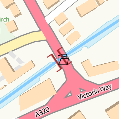
Wheatsheaf Bridge (Woking)
Basingstoke Canal, Chobham Road, Woking GU21 4AA, United Kingdom
Wheatsheaf Bridge (Woking)
is a place on the waterways
on the Basingstoke Canal between
Woodham Junction (Junction of Basingstoke Canal with River Wey) (3 miles and 7¼ furlongs
and 6 locks
to the east) and
Odiham Castle Stop (End of Navigation) (26 miles and 5¾ furlongs
and 23 locks
to the west).
The nearest place in the direction of Woodham Junction is Chertsey Road Bridge;
3 furlongs
away.
The nearest place in the direction of Odiham Castle Stop is Brewery Bridge;
¾ furlongs
away.
There may be access to the towpath here.
Mooring here is unrated.
There is a bridge here which takes a major road over the canal.
| Woodham Top Lock No 6 | 2 miles, 3 furlongs | |
| Paxton Gardens Winding Hole | 2 miles, 1¼ furlongs | |
| Sheerwater Turn | 1 mile, 4½ furlongs | |
| Maybury Hill Bridge | 6¼ furlongs | |
| Chertsey Road Bridge | 3 furlongs | |
| Wheatsheaf Bridge (Woking) | ||
| Brewery Bridge | ¾ furlongs | |
| Lockfield Drive Bridge | 2½ furlongs | |
| Step Bridge Path Footbridge | 4½ furlongs | |
| Arthurs Bridge Winding Hole | 6 furlongs | |
| Arthur's Bridge | 6¼ furlongs | |
Amenities here
Amenities nearby at Brewery Bridge


There are no links to external websites from here.
Why not log in and add some (select "External websites" from the menu (sometimes this is under "Edit"))?
Why not log in and add some (select "External websites" from the menu (sometimes this is under "Edit"))?
Mouseover for more information or show routes to facility
Nearest water point
In the direction of Odiham Castle Stop
Arthur's Bridge — 6¼ furlongs away
On this waterway in the direction of Odiham Castle Stop
Canal Centre Swing Bridge — 9 miles, ½ furlongs and 22 locks away
On this waterway in the direction of Odiham Castle Stop
Mytchett Bridge — 9 miles, 1½ furlongs and 22 locks away
On this waterway in the direction of Odiham Castle Stop
Ash Lock Canal Depot — 12 miles, 4 furlongs and 23 locks away
On this waterway in the direction of Odiham Castle Stop
The Fox and Hounds (Crookham) — 18 miles, 2¼ furlongs and 23 locks away
On this waterway in the direction of Odiham Castle Stop
In the direction of Woodham Junction
Pyrford Lock No 12 — 5 miles, 6¾ furlongs and 6 locks away
Travel to Woodham Junction, then on the River Wey Wey Navigation to Pyrford Lock No 12
Thames Lock No 16 — 6 miles, 4¾ furlongs and 9 locks away
Travel to Woodham Junction, then on the River Wey Wey Navigation to Thames Lock No 16
Cartbridge Wharf — 9 miles, 4½ furlongs and 10 locks away
Travel to Woodham Junction, then on the River Wey Wey Navigation to Cartbridge Wharf
Chertsey Lock — 8 miles, 7¾ furlongs and 11 locks away
Travel to Woodham Junction, then on the River Wey Wey Navigation to Thames - Wey Junction, then on the River Thames (below Oxford) to Chertsey Lock
Molesey Lock — 12 miles, 3 furlongs and 11 locks away
Travel to Woodham Junction, then on the River Wey Wey Navigation to Thames - Wey Junction, then on the River Thames (below Oxford) to West End of Desborough Cut, then on the River Thames (Desborough Cut) to Thames Meadow, then on the River Thames (below Oxford) to Molesey Lock
Stoke Lock No 5 — 13 miles, 6¾ furlongs and 13 locks away
Travel to Woodham Junction, then on the River Wey Wey Navigation to Stoke Lock No 5
Guildford Waterside Centre — 14 miles, 3½ furlongs and 14 locks away
Travel to Woodham Junction, then on the River Wey Wey Navigation to Guildford Waterside Centre
Dapdune Wharf — 15 miles, 3¼ furlongs and 14 locks away
Travel to Woodham Junction, then on the River Wey Wey Navigation to Dapdune Wharf
Teddington Lock Weir Exit — 17 miles and 13 locks away
Travel to Woodham Junction, then on the River Wey Wey Navigation to Thames - Wey Junction, then on the River Thames (below Oxford) to West End of Desborough Cut, then on the River Thames (Desborough Cut) to Thames Meadow, then on the River Thames (below Oxford) to Teddington Lock Weir ExitNearest rubbish disposal
In the direction of Odiham Castle Stop
Arthur's Bridge — 6¼ furlongs away
On this waterway in the direction of Odiham Castle Stop
Canal Centre Swing Bridge — 9 miles, ½ furlongs and 22 locks away
On this waterway in the direction of Odiham Castle Stop
Mytchett Bridge — 9 miles, 1½ furlongs and 22 locks away
On this waterway in the direction of Odiham Castle Stop
Ash Lock Canal Depot — 12 miles, 4 furlongs and 23 locks away
On this waterway in the direction of Odiham Castle Stop
In the direction of Woodham Junction
Pyrford Lock No 12 — 5 miles, 6¾ furlongs and 6 locks away
Travel to Woodham Junction, then on the River Wey Wey Navigation to Pyrford Lock No 12
Shepperton Lock — 7 miles and 10 locks away
Travel to Woodham Junction, then on the River Wey Wey Navigation to Thames - Wey Junction, then on the River Thames (below Oxford) to Shepperton Lock
Penton Hook Lock — 10 miles, 7 furlongs and 12 locks away
Travel to Woodham Junction, then on the River Wey Wey Navigation to Thames - Wey Junction, then on the River Thames (below Oxford) to Penton Hook Lock
Molesey Lock — 12 miles, 3 furlongs and 11 locks away
Travel to Woodham Junction, then on the River Wey Wey Navigation to Thames - Wey Junction, then on the River Thames (below Oxford) to West End of Desborough Cut, then on the River Thames (Desborough Cut) to Thames Meadow, then on the River Thames (below Oxford) to Molesey Lock
Bell Weir Lock — 13 miles, 5¼ furlongs and 13 locks away
Travel to Woodham Junction, then on the River Wey Wey Navigation to Thames - Wey Junction, then on the River Thames (below Oxford) to Bell Weir Lock
Guildford Waterside Centre — 14 miles, 3½ furlongs and 14 locks away
Travel to Woodham Junction, then on the River Wey Wey Navigation to Guildford Waterside Centre
Dapdune Wharf — 15 miles, 3¼ furlongs and 14 locks away
Travel to Woodham Junction, then on the River Wey Wey Navigation to Dapdune Wharf
Teddington Lock Weir Exit — 17 miles and 13 locks away
Travel to Woodham Junction, then on the River Wey Wey Navigation to Thames - Wey Junction, then on the River Thames (below Oxford) to West End of Desborough Cut, then on the River Thames (Desborough Cut) to Thames Meadow, then on the River Thames (below Oxford) to Teddington Lock Weir ExitNearest chemical toilet disposal
In the direction of Odiham Castle Stop
Arthur's Bridge — 6¼ furlongs away
On this waterway in the direction of Odiham Castle Stop
Canal Centre Swing Bridge — 9 miles, ½ furlongs and 22 locks away
On this waterway in the direction of Odiham Castle Stop
In the direction of Woodham Junction
Pyrford Lock No 12 — 5 miles, 6¾ furlongs and 6 locks away
Travel to Woodham Junction, then on the River Wey Wey Navigation to Pyrford Lock No 12
Shepperton Lock — 7 miles and 10 locks away
Travel to Woodham Junction, then on the River Wey Wey Navigation to Thames - Wey Junction, then on the River Thames (below Oxford) to Shepperton Lock
Molesey Lock — 12 miles, 3 furlongs and 11 locks away
Travel to Woodham Junction, then on the River Wey Wey Navigation to Thames - Wey Junction, then on the River Thames (below Oxford) to West End of Desborough Cut, then on the River Thames (Desborough Cut) to Thames Meadow, then on the River Thames (below Oxford) to Molesey Lock
Guildford Waterside Centre — 14 miles, 3½ furlongs and 14 locks away
Travel to Woodham Junction, then on the River Wey Wey Navigation to Guildford Waterside CentreNearest place to turn
In the direction of Odiham Castle Stop
Arthurs Bridge Winding Hole — 6 furlongs away
On this waterway in the direction of Odiham Castle Stop
Blackhorse Road Winding Hole — 2 miles, 6½ furlongs and 5 locks away
On this waterway in the direction of Odiham Castle Stop
Hermitage Bridge Winding Hole — 2 miles, 7¾ furlongs and 5 locks away
On this waterway in the direction of Odiham Castle Stop
Connaught Crescent Winding Hole — 4 miles, 3 furlongs and 8 locks away
On this waterway in the direction of Odiham Castle Stop
Frimley Bottom Lock Winding Hole — 4 miles, 5½ furlongs and 9 locks away
On this waterway in the direction of Odiham Castle Stop
Frimley Lock Winding Hole — 5 miles, 4¼ furlongs and 13 locks away
On this waterway in the direction of Odiham Castle Stop
Lock No 26 Winding Hole — 6 miles, 3½ furlongs and 19 locks away
On this waterway in the direction of Odiham Castle Stop
In the direction of Woodham Junction
Paxton Gardens Winding Hole — 2 miles, 1¼ furlongs away
On this waterway in the direction of Woodham Junction
Woodham Junction — 3 miles, 7¼ furlongs and 6 locks away
On this waterway in the direction of Woodham Junction
Coxes Railway Bridge Winding Hole — 5 miles, 3 furlongs and 8 locks away
Travel to Woodham Junction, then on the River Wey Wey Navigation to Coxes Railway Bridge Winding Hole
Newark Lock Weir Exit No 2 — 7 miles, 2¼ furlongs and 8 locks away
Travel to Woodham Junction, then on the River Wey Wey Navigation to Newark Lock Weir Exit No 2
Newark Lock Weir Exit No 1 — 7 miles, 3 furlongs and 8 locks away
Travel to Woodham Junction, then on the River Wey Wey Navigation to Newark Lock Weir Exit No 1
Newark Lock Weir Entrance — 7 miles, 5¼ furlongs and 9 locks away
Travel to Woodham Junction, then on the River Wey Wey Navigation to Newark Lock Weir Entrance
Five Ways Junction — 6 miles, 6¼ furlongs and 10 locks away
Travel to Woodham Junction, then on the River Wey Wey Navigation to Five Ways Junction
Papercourt Lock Weir Exit — 8 miles, ¼ furlongs and 9 locks away
Travel to Woodham Junction, then on the River Wey Wey Navigation to Papercourt Lock Weir Exit
Worsfold Flood Gates Weir Entrance — 9 miles, 7 furlongs and 11 locks away
Travel to Woodham Junction, then on the River Wey Wey Navigation to Worsfold Flood Gates Weir Entrance
Worsfold Winding Hole — 10 miles and 11 locks away
Travel to Woodham Junction, then on the River Wey Wey Navigation to Worsfold Winding Hole
Triggs Lock Weir Exit — 10 miles, 3¼ furlongs and 11 locks away
Travel to Woodham Junction, then on the River Wey Wey Navigation to Triggs Lock Weir Exit
Stoke Lock Weir Entrance — 14 miles, 2½ furlongs and 14 locks away
Travel to Woodham Junction, then on the River Wey Wey Navigation to Stoke Lock Weir Entrance
Guildford Waterside Centre — 14 miles, 3½ furlongs and 14 locks away
Travel to Woodham Junction, then on the River Wey Wey Navigation to Guildford Waterside CentreNearest self-operated pump-out
In the direction of Odiham Castle Stop
Canal Centre Swing Bridge — 9 miles, ½ furlongs and 22 locks away
On this waterway in the direction of Odiham Castle Stop
Mytchett Bridge — 9 miles, 1½ furlongs and 22 locks away
On this waterway in the direction of Odiham Castle Stop
In the direction of Woodham Junction
Molesey Lock — 12 miles, 3 furlongs and 11 locks away
Travel to Woodham Junction, then on the River Wey Wey Navigation to Thames - Wey Junction, then on the River Thames (below Oxford) to West End of Desborough Cut, then on the River Thames (Desborough Cut) to Thames Meadow, then on the River Thames (below Oxford) to Molesey LockNo information
CanalPlan has no information on any of the following facilities within range:boatyard pump-out
Direction of TV transmitter (From Wolfbane Cybernetic)


 by Basher Eyre – 30 December 2021")

 by Basher Eyre – 30 December 2021")


. The Lightbox is a museum, art gallery, caf̩ and meeting space in central Woking. When I went there was an exhibition of artwork by Bridget Riley https://www.tate.org.uk/art/artists/bridget-riley-1845 as well as a guitar belonging to Paul Weller https://www.paulweller.com/news/ and displays about McLaren https://www.mclaren.com/applied/locations/ Brookwood Cemetery and britain's first purpose built Mosque https://shahjahanmosque.org.uk/the-mosque/history/ by Basher Eyre Р30 December 2021")
 by Basher Eyre – 30 December 2021")
 by Basher Eyre – 30 December 2021")
. The Lightbox is a museum, art gallery, caf̩ and meeting space in central Woking. When I went there was an exhibition of artwork by Bridget Riley https://www.tate.org.uk/art/artists/bridget-riley-1845 as well as a guitar belonging to Paul Weller https://www.paulweller.com/news/ and displays about McLaren https://www.mclaren.com/applied/locations/ Brookwood Cemetery and britain's first purpose built Mosque https://shahjahanmosque.org.uk/the-mosque/history/ by Basher Eyre Р30 December 2021")
. The Lightbox is a museum, art gallery, caf̩ and meeting space in central Woking. When I went there was an exhibition of artwork by Bridget Riley https://www.tate.org.uk/art/artists/bridget-riley-1845 as well as a guitar belonging to Paul Weller https://www.paulweller.com/news/ and displays about McLaren https://www.mclaren.com/applied/locations/ Brookwood Cemetery and britain's first purpose built Mosque https://shahjahanmosque.org.uk/the-mosque/history/ by Basher Eyre Р30 December 2021")


There is no page on Wikipedia called “Wheatsheaf Bridge”
Wikipedia pages that might relate to Wheatsheaf Bridge
[The Wheatsheaf, Southwark]
website. "Thameslink rail bridge installed above Wheatsheaf at Borough Market". team, London SE1 website. "The Wheatsheaf is back: but which is the true
[Hubberts Bridge]
surveyor. The village is served by Hubberts Bridge railway station, and has a local public house, the Wheatsheaf Inn, and a community centre. "Lincs to the
[Patna, East Ayrshire]
Patna Campus, a health centre, some shops, a football field, a bar “The Wheatsheaf Inn”, access to numerous country walks, an orange and masonic lodge and
[Complete information]
August 2016. Gibbons, Robert (1992). A Primer in Game Theory. Harvester-Wheatsheaf. p. 133. Osborne, M. J.; Rubinstein, A. (1994). "Chapter 6: Extensive
[Blackfriars, London]
the City – in the south-east of today's Blackfriars. Among these were Wheatsheaf Wharf. Paul's Stairs is east of the modern floating pier, leading to the
[Mass stabbing]
and Youssef Zaghba. All of them were shot dead by armed police near Wheatsheaf pub. A total of 46 gunshots was fired during the police operation. The
[Perfect information]
Chapter 3, sect 2.2) Gibbons, R. (1992) A primer in game theory, Harvester-Wheatsheaf. (see Chapter 2) Luce, R.D. and Raiffa, H. (1957) Games and Decisions:
[Chilton Foliat]
historian and author, lives here. The village has a public house, the Wheatsheaf (in an early 19th-century thatched house) and a village hall (dating from
[Borough Market]
had its upper floors removed, as has the Wheatsheaf public house on Stoney Street, for the new railway bridge to cross over them. The remaining floors
[Game theory]
as Gibbons, Robert (2001), A Primer in Game Theory, London: Harvester Wheatsheaf, ISBN 978-0-7450-1159-2. Gintis, Herbert (2000), Game theory evolving:
Results of Google Search
A two-mile stretch from the Wheatsheaf Bridge in the town centre to Kiln Bridge, St Johns, features several bridges, two locks and abundant wildlife and can be ...
Wheatsheaf Bridge. (Horsell Bridge in WOTW). Basingstoke ... The Wells in Woking Heritage Trail. @wellsinwoking. Woking Railway Station to Wells' house.
and Woking' and rose early with the idea of finding it. 'Find it he did ... ' Wheatsheaf Bridge', with the potman working at what is now the ... www. wokinghistory.org.
The cheapest way to get from Woking to Bough Beech, The Wheatsheaf costs only £7, and the quickest way takes just 47 mins. Find the travel option that best ...
Surrey Postcard. Victorian Cottage Hospital & Wheatsheaf Bridge, Woking | Collectables, Postcards, Topographical: British | eBay!
Canal from Wheatsheaf Bridge. 1912? [4912]. Canal Lock, St. John's, Woking. [ 5005]. Cartbridge. 1905. [7587]. Chapel & Dutch Garden, St. Peter's Memorial ...
Book a table at The Wheatsheaf, see menus & prices + Vegan menu, opening times, directions, offers & what's on. Your local Woking pub near you!
... Road Bridge, Woking (06) Chobham Road Bridge, Woking. (aka Wheatsheaf Br, Hospital Br) (07) Skew Bridge - carries the bypass road from Woking ...
Book your stay at The Wheatsheaf today & enjoy a complimentary breakfast, WiFi & parking for the duration of your stay.