

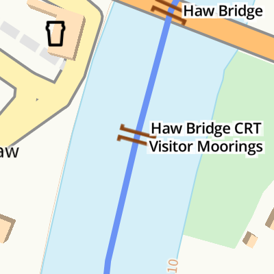
Haw Bridge CRT Visitor Moorings 
Haw Bridge, Tirley, GL19 4HJ, United Kingdom
Haw Bridge CRT Visitor Moorings
is a minor waterways place
on the River Severn (main river - Worcester to Gloucester) between
Chaceley and Deerhurst (1 mile and 7¾ furlongs
to the northeast) and
Severn - Coombe Hill Canal Junction (Junction of the River Severn and the long derelict and abandoned Coombe Hill Canal) (1 mile
to the south).
The nearest place in the direction of Chaceley and Deerhurst is Haw Bridge (Bridge opened in 1961 to replace one demolished by a collision with a barge.);
¼ furlongs
away.
The nearest place in the direction of Severn - Coombe Hill Canal Junction is Unidentifed Sluice (Sluice gates for an unknown stream which takes water from the old Coombe Hill Canal.);
7¼ furlongs
away.
There is access (via steps) to the towpath here.
Mooring here is good (a nice place to moor), mooring rings or bollards are available. Mooring is limited to 24 hours. Short floating pontoon, space for only two full-length narrowboats (be prepared to butty up) with no other safe mooring nearby. Do NOT moor on inside of pontoon. Access via very steep ramp. August 2024 Pub reopened earlier this year. Poor internet signal. .
There is a bridge here.
| Upper Lode Lock Weir Exit | 4 miles, ¾ furlongs | |
| Tewkesbury Lower Lode | 3 miles, 4¾ furlongs | |
| Chaceley and Deerhurst | 1 mile, 7¾ furlongs | |
| Apperley | 6¼ furlongs | |
| Haw Bridge | ¼ furlongs | |
| Haw Bridge CRT Visitor Moorings | ||
| Unidentifed Sluice | 7¼ furlongs | |
| Severn - Coombe Hill Canal Junction | 1 mile | |
| Severn - Chelt Junction | 1 mile, 1 furlong | |
| Wainlodes Hill | 1 mile, 2½ furlongs | |
| The Boat Inn (Ashleworth) | 3 miles, 1¾ furlongs | |
Amenities here


There are no links to external websites from here.
Why not log in and add some (select "External websites" from the menu (sometimes this is under "Edit"))?
Why not log in and add some (select "External websites" from the menu (sometimes this is under "Edit"))?
Mouseover for more information or show routes to facility
Nearest water point
In the direction of Gloucester / Sharpness - Severn Junction
Gloucester Dock Lock — 8 miles, 1¼ furlongs away
Travel to Gloucester / Sharpness - Severn Junction, then on the Gloucester and Sharpness Canal to Gloucester Dock Lock
Gloucester Waterways Museum Arm — 8 miles, 2¼ furlongs and 1 lock away
Travel to Gloucester / Sharpness - Severn Junction, then on the Gloucester and Sharpness Canal to Gloucester Waterways Museum Arm
Llanthony Road Bridge — 8 miles, 2½ furlongs and 1 lock away
Travel to Gloucester / Sharpness - Severn Junction, then on the Gloucester and Sharpness Canal to Llanthony Road Bridge
Llanthony Pontoons — 8 miles, 3½ furlongs and 1 lock away
Travel to Gloucester / Sharpness - Severn Junction, then on the Gloucester and Sharpness Canal to Llanthony Pontoons
Sellars Bridge — 12 miles, 1¼ furlongs and 1 lock away
Travel to Gloucester / Sharpness - Severn Junction, then on the Gloucester and Sharpness Canal to Sellars Bridge
Saul Junction Winding Hole — 15 miles, 7¾ furlongs and 1 lock away
Travel to Gloucester / Sharpness - Severn Junction, then on the Gloucester and Sharpness Canal to Saul Junction Winding Hole
Saul Junction Marina — 16 miles, ½ furlongs and 1 lock away
Travel to Gloucester / Sharpness - Severn Junction, then on the Gloucester and Sharpness Canal to Saul Junction, then on the Cotswold Canals (Stroudwater Navigation - Navigable Section) to Saul Junction Marina
Cotswold Canals Trust Visitor Centre - Saul Junction — 16 miles, ½ furlongs and 1 lock away
Travel to Gloucester / Sharpness - Severn Junction, then on the Gloucester and Sharpness Canal to Cotswold Canals Trust Visitor Centre - Saul Junction
Fretherne Bridge — 16 miles, 5¾ furlongs and 1 lock away
Travel to Gloucester / Sharpness - Severn Junction, then on the Gloucester and Sharpness Canal to Fretherne Bridge
Splatt Bridge — 17 miles, 6½ furlongs and 1 lock away
Travel to Gloucester / Sharpness - Severn Junction, then on the Gloucester and Sharpness Canal to Splatt Bridge
Patch Bridge — 19 miles, 5¼ furlongs and 1 lock away
Travel to Gloucester / Sharpness - Severn Junction, then on the Gloucester and Sharpness Canal to Patch Bridge
In the direction of Diglis Junction
Tewkesbury Lower Lode — 3 miles, 4¾ furlongs away
On this waterway in the direction of Diglis Junction
Upper Lode Lock No 5 — 4 miles, 2¾ furlongs away
On this waterway in the direction of Diglis Junction
Tewkesbury Services — 5 miles, ¾ furlongs and 2 locks away
Travel to Tewkesbury Junction, then on the River Avon - Warwickshire (Lower Avon Navigation) to Tewkesbury Services
Bredon — 8 miles, 4½ furlongs and 2 locks away
Travel to Tewkesbury Junction, then on the River Avon - Warwickshire (Lower Avon Navigation) to Bredon
Strensham Lock — 10 miles, 5 furlongs and 2 locks away
Travel to Tewkesbury Junction, then on the River Avon - Warwickshire (Lower Avon Navigation) to Strensham Lock
Pershore Recreation Ground — 19 miles, ¾ furlongs and 5 locks away
Travel to Tewkesbury Junction, then on the River Avon - Warwickshire (Lower Avon Navigation) to Pershore Recreation GroundNearest rubbish disposal
In the direction of Gloucester / Sharpness - Severn Junction
Llanthony Road Bridge — 8 miles, 2½ furlongs and 1 lock away
Travel to Gloucester / Sharpness - Severn Junction, then on the Gloucester and Sharpness Canal to Llanthony Road Bridge
Sellars Bridge — 12 miles, 1¼ furlongs and 1 lock away
Travel to Gloucester / Sharpness - Severn Junction, then on the Gloucester and Sharpness Canal to Sellars Bridge
Parkend Bridge — 14 miles, 2¾ furlongs and 1 lock away
Travel to Gloucester / Sharpness - Severn Junction, then on the Gloucester and Sharpness Canal to Parkend Bridge
Saul Junction Winding Hole — 15 miles, 7¾ furlongs and 1 lock away
Travel to Gloucester / Sharpness - Severn Junction, then on the Gloucester and Sharpness Canal to Saul Junction Winding Hole
Saul Junction Marina — 16 miles, ½ furlongs and 1 lock away
Travel to Gloucester / Sharpness - Severn Junction, then on the Gloucester and Sharpness Canal to Saul Junction, then on the Cotswold Canals (Stroudwater Navigation - Navigable Section) to Saul Junction Marina
Fretherne Bridge — 16 miles, 5¾ furlongs and 1 lock away
Travel to Gloucester / Sharpness - Severn Junction, then on the Gloucester and Sharpness Canal to Fretherne Bridge
Splatt Bridge — 17 miles, 6½ furlongs and 1 lock away
Travel to Gloucester / Sharpness - Severn Junction, then on the Gloucester and Sharpness Canal to Splatt Bridge
Patch Bridge — 19 miles, 5¼ furlongs and 1 lock away
Travel to Gloucester / Sharpness - Severn Junction, then on the Gloucester and Sharpness Canal to Patch Bridge
In the direction of Diglis Junction
Tewkesbury Services — 5 miles, ¾ furlongs and 2 locks away
Travel to Tewkesbury Junction, then on the River Avon - Warwickshire (Lower Avon Navigation) to Tewkesbury Services
Pershore Bridge Moorings — 18 miles, 3½ furlongs and 4 locks away
Travel to Tewkesbury Junction, then on the River Avon - Warwickshire (Lower Avon Navigation) to Pershore Bridge Moorings
Pershore New Bridge — 18 miles, 4 furlongs and 4 locks away
Travel to Tewkesbury Junction, then on the River Avon - Warwickshire (Lower Avon Navigation) to Pershore New Bridge
Pershore Recreation Ground — 19 miles, ¾ furlongs and 5 locks away
Travel to Tewkesbury Junction, then on the River Avon - Warwickshire (Lower Avon Navigation) to Pershore Recreation GroundNearest chemical toilet disposal
In the direction of Gloucester / Sharpness - Severn Junction
Llanthony Road Bridge — 8 miles, 2½ furlongs and 1 lock away
Travel to Gloucester / Sharpness - Severn Junction, then on the Gloucester and Sharpness Canal to Llanthony Road Bridge
Saul Junction Marina — 16 miles, ½ furlongs and 1 lock away
Travel to Gloucester / Sharpness - Severn Junction, then on the Gloucester and Sharpness Canal to Saul Junction, then on the Cotswold Canals (Stroudwater Navigation - Navigable Section) to Saul Junction Marina
Cotswold Canals Trust Visitor Centre - Saul Junction — 16 miles, ½ furlongs and 1 lock away
Travel to Gloucester / Sharpness - Severn Junction, then on the Gloucester and Sharpness Canal to Cotswold Canals Trust Visitor Centre - Saul Junction
In the direction of Diglis Junction
Pershore Recreation Ground — 19 miles, ¾ furlongs and 5 locks away
Travel to Tewkesbury Junction, then on the River Avon - Warwickshire (Lower Avon Navigation) to Pershore Recreation GroundNearest place to turn
In the direction of Gloucester / Sharpness - Severn Junction
Upper Parting Junction — 5 miles, 4¼ furlongs away
On this waterway in the direction of Gloucester / Sharpness - Severn Junction
Gloucester / Sharpness - Severn Junction — 8 miles, 1 furlong away
On this waterway in the direction of Gloucester / Sharpness - Severn Junction
Waterways Office (South Wales and Severn Waterways) - Canal & River Trust — 8 miles, 1½ furlongs and 1 lock away
Travel to Gloucester / Sharpness - Severn Junction, then on the Gloucester and Sharpness Canal to Waterways Office (South Wales and Severn Waterways) - Canal & River Trust
Over Winding Hole — 7 miles, 2¼ furlongs and 2 locks away
Travel to Upper Parting Junction, then on the River Severn (Maisemore Channel - Northern Section) to Over Junction, then on the Hereford and Gloucester Canal to Over Winding Hole
Gloucester Docks — 8 miles, 1¾ furlongs and 1 lock away
Travel to Gloucester / Sharpness - Severn Junction, then on the Gloucester and Sharpness Canal to Gloucester Docks
Monk Meadow Dock — 8 miles, 5¾ furlongs and 1 lock away
Travel to Gloucester / Sharpness - Severn Junction, then on the Gloucester and Sharpness Canal to Monk Meadow Dock
Quedgeley Oil Depot — 12 miles and 1 lock away
Travel to Gloucester / Sharpness - Severn Junction, then on the Gloucester and Sharpness Canal to Quedgeley Oil Depot
Pegthorne Bridge Winding Hole — 15 miles, 2½ furlongs and 1 lock away
Travel to Gloucester / Sharpness - Severn Junction, then on the Gloucester and Sharpness Canal to Pegthorne Bridge Winding Hole
Saul Junction Winding Hole — 15 miles, 7¾ furlongs and 1 lock away
Travel to Gloucester / Sharpness - Severn Junction, then on the Gloucester and Sharpness Canal to Saul Junction Winding Hole
In the direction of Diglis Junction
Upper Lode Lock Weir Exit — 4 miles, ¾ furlongs away
On this waterway in the direction of Diglis Junction
Upper Lode Lock Weir Entrance — 4 miles, 3¾ furlongs and 1 lock away
On this waterway in the direction of Diglis Junction
Avon Lock Junction — 5 miles, ½ furlongs and 2 locks away
Travel to Tewkesbury Junction, then on the River Avon - Warwickshire (Lower Avon Navigation) to Avon Lock Junction
Abbey Mill Tewkesbury — 5 miles, 1½ furlongs and 2 locks away
Travel to Tewkesbury Junction, then on the River Avon - Warwickshire (Lower Avon Navigation) to Avon Lock Junction, then on the River Avon - Warwickshire (Mill Avon) to Abbey Mill Tewkesbury
Tewkesbury Marina Entrance No 2 — 5 miles, 4½ furlongs and 2 locks away
Travel to Tewkesbury Junction, then on the River Avon - Warwickshire (Lower Avon Navigation) to Tewkesbury Marina Entrance No 2
Nafford Lock Weir Exit No 2 — 13 miles, 7½ furlongs and 3 locks away
Travel to Tewkesbury Junction, then on the River Avon - Warwickshire (Lower Avon Navigation) to Nafford Lock Weir Exit No 2
Nafford Lock Weir Entrance No 1 — 14 miles, ½ furlongs and 4 locks away
Travel to Tewkesbury Junction, then on the River Avon - Warwickshire (Lower Avon Navigation) to Nafford Lock Weir Entrance No 1
Severn - Teme Junction — 19 miles, 6 furlongs and 1 lock away
On this waterway in the direction of Diglis Junction
Pershore Lock Weir Exit No 1 — 18 miles, 6 furlongs and 4 locks away
Travel to Tewkesbury Junction, then on the River Avon - Warwickshire (Lower Avon Navigation) to Pershore Lock Weir Exit No 1
Pershore Lock Weir Entrance No 2 — 18 miles, 6¾ furlongs and 5 locks away
Travel to Tewkesbury Junction, then on the River Avon - Warwickshire (Lower Avon Navigation) to Pershore Lock Weir Entrance No 2
Wyre Lock Weir Entrance — 19 miles, 7¼ furlongs and 6 locks away
Travel to Tewkesbury Junction, then on the River Avon - Warwickshire (Lower Avon Navigation) to Wyre Lock Weir EntranceNearest self-operated pump-out
In the direction of Gloucester / Sharpness - Severn Junction
Llanthony Pontoons — 8 miles, 3½ furlongs and 1 lock away
Travel to Gloucester / Sharpness - Severn Junction, then on the Gloucester and Sharpness Canal to Llanthony Pontoons
Cotswold Canals Trust Visitor Centre - Saul Junction — 16 miles, ½ furlongs and 1 lock away
Travel to Gloucester / Sharpness - Severn Junction, then on the Gloucester and Sharpness Canal to Cotswold Canals Trust Visitor Centre - Saul JunctionNearest boatyard pump-out
In the direction of Gloucester / Sharpness - Severn Junction
Saul Junction Marina — 16 miles, ½ furlongs and 1 lock away
Travel to Gloucester / Sharpness - Severn Junction, then on the Gloucester and Sharpness Canal to Saul Junction, then on the Cotswold Canals (Stroudwater Navigation - Navigable Section) to Saul Junction Marina
Patch Bridge — 19 miles, 5¼ furlongs and 1 lock away
Travel to Gloucester / Sharpness - Severn Junction, then on the Gloucester and Sharpness Canal to Patch Bridge
In the direction of Diglis Junction
Pershore Recreation Ground — 19 miles, ¾ furlongs and 5 locks away
Travel to Tewkesbury Junction, then on the River Avon - Warwickshire (Lower Avon Navigation) to Pershore Recreation GroundDirection of TV transmitter (From Wolfbane Cybernetic)


There is no page on Wikipedia called “Haw Bridge CRT Visitor Moorings”
Wikipedia pages that might relate to Haw Bridge CRT Visitor Moorings
[Brooklyn Bridge]
OCLC 57710987. Haw, Richard (2005). The Brooklyn Bridge : a cultural history. Rutgers University Press. ISBN 978-0-8135-3587-6. OCLC 56526458. Haw, Richard
[Moores Creek National Battlefield]
battlefield and across Moores Creek. The historic bridge site is located along the trail. The park, located in a rural area, offers a visitor center with exhibits
[North Yorkshire]
study of visitors between 2013 and 2015 indicated that the Borough of Scarborough, including Filey, Whitby and parts of the North York Moors National
[Southwark]
London Bridge Station. To the north is the River Thames, London Bridge station and Southwark Cathedral. Borough Market is a well-developed visitor attraction
[Settle–Carlisle line]
England. Garsdale – originally named Hawes Junction then Hawes Junction & Garsdale. At Hawes station, on the Hawes branch to the east of the main line
[Inchcolm]
during both World Wars to defend nearby Edinburgh. Inchcolm now attracts visitors to its former Augustine Abbey. Inchcolm lies in the Firth of Forth off
[Wey and Godalming Navigations]
lock on the Navigation with a rise of 8 feet 6 inches (2.59 m). Between New Haw Lock and Pyrford Lock is one end of the Basingstoke Canal just before the
[Hebden, North Yorkshire]
identified on the banks of Gate Up Gill on the moors to the north-west of the village. Place names such as Scale Haw indicate the Norse left their influence
[Ribblehead railway station]
occasional bus service is operated on summer Sundays and bank holidays, between Hawes and Settle via Ribblehead (in 2019, one journey each way). At other times
[Morpeth, Northumberland]
was built later in the 13th century by Ranulph de Merlay, to the south of Haw Hill, there is no firm evidence that King John destroyed the castle and an