

Upperton Road Bridge
Upperton Road, Leicester LE2 7JD, United Kingdom
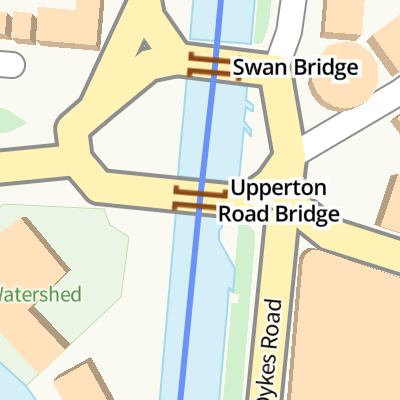
Upperton Road Bridge
is a minor waterways place
on the Grand Union Canal (Leicester Section - River Soar Navigation) between
River Soar Junction (Junction of GU Leicester Section and River Soar Navigation) (2 miles and ½ furlongs
and 3 locks
to the southwest) and
Soar Lane Bridge No 3 (7½ furlongs
to the north).
The nearest place in the direction of River Soar Junction is Upperton Road Bridge Arm (Exit of the Old River Soar);
¾ furlongs
away.
The nearest place in the direction of Soar Lane Bridge No 3 is Swan Bridge (The new Swan Bridge 1998 is paired with Walnut Street Bridge (Upperton Road Bridge) to create a roundabout. );
¼ furlongs
away.
There may be access to the towpath here.
Mooring here is unrated.
There is a bridge here which takes a minor road over the canal.
| Branch of the Soar Junction | 3¾ furlongs | |
| Echo Railway Bridge | 3½ furlongs | |
| Leicester City Football Club | 2¾ furlongs | |
| Freeman's Lock No 41 | 2½ furlongs | |
| Upperton Road Bridge Arm | ¾ furlongs | |
| Upperton Road Bridge | ||
| Swan Bridge | ¼ furlongs | |
| Mill Lane Bridge No 110 | 1¾ furlongs | |
| Newarke Bridge No 111 | 3 furlongs | |
| Leicester Visitor Moorings | 3½ furlongs | |
| Castle Gardens Pedestrian Bridge | 3¾ furlongs | |
Amenities here
Amenities nearby at Upperton Road Bridge Arm
Amenities nearby at Swan Bridge


- Grand Union Canal Walk — associated with Grand Union Canal
- An illustrated walk along the Grand Union Canal from London to Birmingham
Mouseover for more information or show routes to facility
Nearest water point
In the direction of Trent Junction
Friars Mill Visitor Moorings — 6¼ furlongs away
On this waterway in the direction of Trent Junction
Hope and Anchor Bridge No 19 — 6 miles, 6 furlongs and 5 locks away
On this waterway in the direction of Trent Junction
Barrow Boating — 12 miles, 3 furlongs and 9 locks away
On this waterway in the direction of Trent Junction
Loughborough Basin — 16 miles, 4½ furlongs and 11 locks away
Travel to Loughborough Branch Junction, then on the Grand Union Canal (Leicester Section - Loughborough Branch) to Loughborough Basin
Bishop Meadow Lock No 54 — 17 miles, 3¼ furlongs and 12 locks away
On this waterway in the direction of Trent Junction
In the direction of River Soar Junction
Kilby Bridge No 87 — 7 miles, 5½ furlongs and 12 locks away
Travel to River Soar Junction, then on the Grand Union Canal (Leicester Section - Leicestershire and Northamptonshire Union Canal) to Kilby Bridge No 87
Foxton Junction — 17 miles, 3¾ furlongs and 24 locks away
Travel to River Soar Junction, then on the Grand Union Canal (Leicester Section - Leicestershire and Northamptonshire Union Canal) to Foxton Junction
Inclined Plane Upper Access Arm Junction — 17 miles, 7 furlongs and 24 locks away
Travel to River Soar Junction, then on the Grand Union Canal (Leicester Section - Leicestershire and Northamptonshire Union Canal) to Foxton Junction, then on the Grand Union Canal (Leicester Section - Market Harborough Branch) to Inclined Plane Lower Access Arm Junction, then on the Grand Union Canal (Leicester Section - Inclined Plane Branch) to Inclined Plane Upper Access Arm JunctionNearest rubbish disposal
In the direction of Trent Junction
Broome Island — 11 miles, 4¾ furlongs and 9 locks away
On this waterway in the direction of Trent Junction
Barrow Boating — 12 miles, 3 furlongs and 9 locks away
On this waterway in the direction of Trent Junction
Loughborough Basin — 16 miles, 4½ furlongs and 11 locks away
Travel to Loughborough Branch Junction, then on the Grand Union Canal (Leicester Section - Loughborough Branch) to Loughborough Basin
In the direction of River Soar Junction
Kilby Bridge No 87 — 7 miles, 5½ furlongs and 12 locks away
Travel to River Soar Junction, then on the Grand Union Canal (Leicester Section - Leicestershire and Northamptonshire Union Canal) to Kilby Bridge No 87
Foxton Junction Swing Bridge — 17 miles, 4 furlongs and 24 locks away
Travel to River Soar Junction, then on the Grand Union Canal (Leicester Section - Leicestershire and Northamptonshire Union Canal) to Foxton Junction, then on the Grand Union Canal (Leicester Section - Market Harborough Branch) to Foxton Junction Swing BridgeNearest chemical toilet disposal
In the direction of Trent Junction
Sileby Mill Mooring Basin — 9 miles, 6¾ furlongs and 8 locks away
On this waterway in the direction of Trent Junction
Barrow Boating — 12 miles, 3 furlongs and 9 locks away
On this waterway in the direction of Trent Junction
In the direction of River Soar Junction
Kilby Bridge No 87 — 7 miles, 5½ furlongs and 12 locks away
Travel to River Soar Junction, then on the Grand Union Canal (Leicester Section - Leicestershire and Northamptonshire Union Canal) to Kilby Bridge No 87
Foxton Junction Swing Bridge — 17 miles, 4 furlongs and 24 locks away
Travel to River Soar Junction, then on the Grand Union Canal (Leicester Section - Leicestershire and Northamptonshire Union Canal) to Foxton Junction, then on the Grand Union Canal (Leicester Section - Market Harborough Branch) to Foxton Junction Swing BridgeNearest place to turn
In the direction of Trent Junction
Memory Lane Wharf — 1 mile, 6¾ furlongs and 1 lock away
On this waterway in the direction of Trent Junction
Belgrave Circle Arm (disused) — 1 mile, 7½ furlongs and 2 locks away
On this waterway in the direction of Trent Junction
Entrance to Riverside Lakes — 3 miles, 2 furlongs and 3 locks away
On this waterway in the direction of Trent Junction
Birstall Lock Winding Hole — 4 miles, 3½ furlongs and 3 locks away
On this waterway in the direction of Trent Junction
White Horse Lane Junction — 4 miles, 4¾ furlongs and 4 locks away
On this waterway in the direction of Trent Junction
Leicester Marina Entrance — 5 miles, 2¾ furlongs and 4 locks away
On this waterway in the direction of Trent Junction
Thurmaston Lock Arm — 5 miles, 4 furlongs and 4 locks away
On this waterway in the direction of Trent Junction
MGM Boats Winding Hole — 5 miles, 4¾ furlongs and 5 locks away
On this waterway in the direction of Trent Junction
MGM Boats, Thurmaston — 5 miles, 5½ furlongs and 5 locks away
On this waterway in the direction of Trent Junction
Old Junction Boatyard (Syston) — 7 miles, 1¾ furlongs and 5 locks away
On this waterway in the direction of Trent Junction
River Wreake Junction — 7 miles, 2¼ furlongs and 5 locks away
On this waterway in the direction of Trent Junction
Wreake Outlet by Junction Lock No 47 — 7 miles, 7 furlongs and 6 locks away
On this waterway in the direction of Trent Junction
Wreake Mouth — 8 miles, 2¼ furlongs and 6 locks away
On this waterway in the direction of Trent Junction
Cossington Mill Stream Junction — 8 miles, 3¾ furlongs and 7 locks away
On this waterway in the direction of Trent Junction
Loughborough Road Winding Hole — 8 miles, 4½ furlongs and 7 locks away
On this waterway in the direction of Trent Junction
Sileby Mill — 9 miles, 6¼ furlongs and 8 locks away
On this waterway in the direction of Trent Junction
Sileby Mill Mooring Basin — 9 miles, 6¾ furlongs and 8 locks away
On this waterway in the direction of Trent Junction
Mountsorrel Lock Junction — 10 miles, 5¼ furlongs and 8 locks away
On this waterway in the direction of Trent Junction
In the direction of River Soar Junction
Blaby Bridge Winding Hole — 4 miles, 4¼ furlongs and 7 locks away
Travel to River Soar Junction, then on the Grand Union Canal (Leicester Section - Leicestershire and Northamptonshire Union Canal) to Blaby Bridge Winding Hole
Bush Lock Winding Hole — 5 miles, 5¼ furlongs and 8 locks away
Travel to River Soar Junction, then on the Grand Union Canal (Leicester Section - Leicestershire and Northamptonshire Union Canal) to Bush Lock Winding HoleNearest self-operated pump-out
In the direction of River Soar Junction
Kilby Bridge No 87 — 7 miles, 5½ furlongs and 12 locks away
Travel to River Soar Junction, then on the Grand Union Canal (Leicester Section - Leicestershire and Northamptonshire Union Canal) to Kilby Bridge No 87Nearest boatyard pump-out
In the direction of Trent Junction
Sileby Mill Mooring Basin — 9 miles, 6¾ furlongs and 8 locks away
On this waterway in the direction of Trent JunctionDirection of TV transmitter (From Wolfbane Cybernetic)


, and is part of a new student development located along Eastern Boulevard. by Mat Fascione – 01 December 2013")


. by Tammy Winand – 25 November 2005")


There is no page on Wikipedia called “Upperton Road Bridge”
Wikipedia pages that might relate to Upperton Road Bridge
[List of crossings of the River Soar]
length, including Upperton Road, Mill Lane, Newarke, and West Bridge. The current West Bridge built in 1891, replaced an earlier stone bridge with four arches
[Green Bicycle Case]
off the serial numbers from the frame. He took the bicycle to the Upperton Road Bridge in Leicester, where he first detached the rear wheel (because the
[Upperton, North Lanarkshire]
Coordinates: 55°55′08″N 3°54′43″W / 55.919°N 3.912°W / 55.919; -3.912 Upperton is a village in North Lanarkshire, Scotland, near Airdrie and Cumbernauld
[Grand Union Canal]
Its last 160 yards (150 m) were lost in the 1970s saving a disused road bridge that stands isolated in a car park. Warwick's narrowboat moorings are
[River Avon, Falkirk]
Burn close to Upperton, north of the sewage works and west of Easter Glentore Farm. The Avon crosses Fannyside Road at the Bog Bridge near Toddle Knowe
[Statue of Liberty (Leicester)]
Lennards Shoe factory was built on the corner of Eastern Boulevard and Upperton Road in 1919. Stephen Butt (2013). "Secret Leicester". The idea to place
[Westcotes]
the rear of 171 Upperton Road which no longer exists. It seems likely that the block was demolished to make way for 167-169 Upperton Road. The picture also
[Garrion Bridge]
Garrion Bridge is a small hamlet spanning the border between North Lanarkshire and South Lanarkshire, Scotland. It is located on the banks of the Clyde
[Cardowan]
and an extension to Clayhouse Road. Following this in the 1960s, Drimnin Road, and Mossview Road (including Resipol Road and Gaskin Path) were completed
[Kilsyth]
Falkirk. The old drovers' road from Stirling, (the Tak Ma Doon Road), and the route south to Cumbernauld via Auchinstarry Bridge, intersect the A803 at Kilsyth
Results of Google Search
File:Upperton Road bridge crossing the Old River Soar (geograph ....jpg)
File:Upperton Road bridge crossing the Old River Soar (geograph 5249976).jpg. Language; Watch · Edit. File; File history; File usage. File:Upperton Road ...
Upperton Road bridge over ex-Great Central Railway, Leicester. Upperton Road viaduct over the Great Central just south of the goods yard in 2007 just before ...
It has four listed crossings along its length, including Upperton Road, Mill Lane, Newarke, and West Bridge. The current West Bridge built in 1891, replaced an ...
Media in category "Upperton Road Bridge (Grand Union Canal)". The following 4 files are in this category, out of 4 total. Canal Bridge (geograph 2116322).jpg ...
May 13, 2020 ... Roads affected by the incident include Upperton Road, Western Boulevard and Eastern Boulevard. Read More. Related Articles. Sports bar ...
Mar 9, 2018 - Goods yard from Upperton Road Bridge in 1973. Coal sidings were about to become Vic Berry's scrapyard.
May 14, 2020 ... Officers closed a section of Upperton Road and Western Boulevard around Swan Bridge at around 6.35pm yesterday. A suspected explosive ...
Overgrown tracks leading towards Upperton Road Bridge, Leicester. 2001.
.jpg)
Dec 20, 2016 ... File:Upperton Road Bridge (geograph 5230675).jpg. Read in another language; Watch this page · Edit. File; File history; File usage on ...
Download this stock image: Green Man detail, Upperton Road Bridge, Leicester, Leicestershire, England, UK - DW4JAP from Alamy's library of millions of high ...